
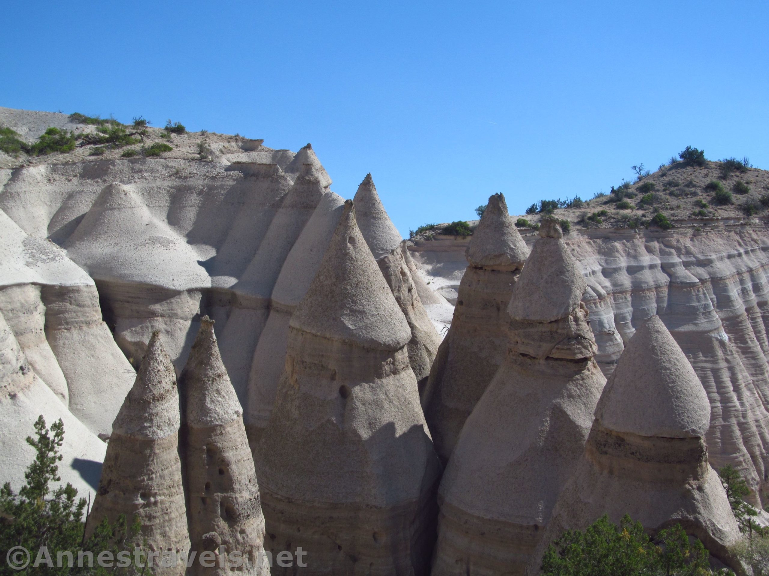

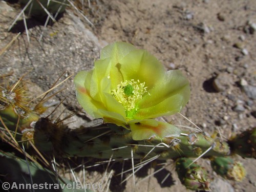
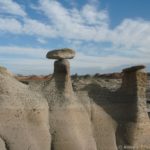
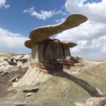
I think one of my favorite trails in northern New Mexico is at Kasha-Katuwe Tent Rocks National Monument. The rocks are really neat, and the trail is definitely not your average path through a national park. It can get crowded on the weekend – the park just isn’t that big – but that’s because it’s so worth seeing. The rock formations are cone-shaped, reminiscent of hats on white hoodoos. It’s hard to believe the pictures are true!
Quick Stats

We visited on a warm Saturday in June – I’d been wanting to visit for years, and time and location finally lined up so we could hike the trail. Fires had closed all the local national forests and part of Bandelier National Monument, but when I called, the park assured me that they were open. In fact, their bigger concern was pets. “Just remember,” they told me a second and third time, “no pets are allowed in the park.” Ok, fine. I don’t even have any pets!
There is only one trailhead, so it’s easy enough to figure out where to go. Most people go straight on the Slot Canyon Trail, but I’d recommend doing what I did, which was to turn left on the Cave Loop (actually, we did it because everyone was going toward the slot canyon and we thought we’d have a little peace and quiet for a bit on the Cave Loop). If you are short on time or energy, don’t take the cave loop at all.

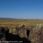
So we turned left on the Cave Loop. The trail meanders across the desert with views to a few of the rock formations, most of them a distance away. You’ll also pass a cave that has historical significance. Overall, scenic and worth your time if you have it.

After 0.8 miles, you’ll arrive back where the Cave Loop meets the trail from the parking lot (parking lot to junction via the straighter path is 0.5 miles; so just to do the Cave Loop and back to the parking area would be a total of 1.3 miles). Turn left up the wash to enter the canyon and continue up the Slot.

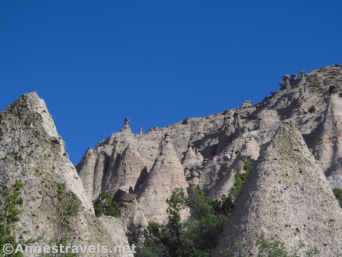
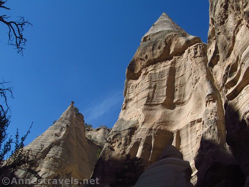
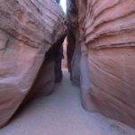
Now is where you get to start enjoying the best part of the hike. The canyon closes in around the trail. The walls are cool in themselves (literally on a hot summer day), but you also get to look up and see the famous Tent Rocks (cone-shaped rock formations that – to me – sometimes look like rockets out of a child’s storybook).

The trail is just the bottom of the wash. So you can’t really get lost. Do be wary of flash floods – if you hear a train or water starts coming, scramble up out of the canyon fast!

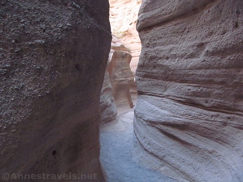
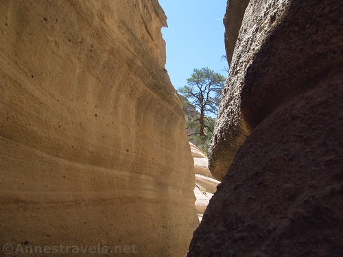
Part way up the canyon, you’ll come to a real slot canyon – so narrow you might have to walk sideways. I love slots like this! On a busy day, people wait their turn at both ends because there’s no place to pass in the slot section.
Keep going up the wash as it rises up through varying scenery. About 1.1 miles from the trail junction, the wash turns to the left to pass beneath some of the best formations. Shortly after this, the trail begins to climb steeply on a crumbly, eroding trail, with occasional scrambling required. It’s a real trail, though it might not look like it. Many people turn around here, and I can’t really blame them. But if you’re going to turn around, walk up far enough to get a view down on the Tent Rocks from above – I can’t decide if they look like rockets or robots, but maybe I have an overactive imagination from getting too many Walter Wick books out of the library when I was young.
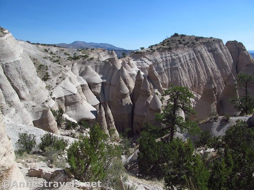
There is a viewpoint just before mile 2. The trail continues to climb higher, out of the canyon, to a second viewpoint at mile 2.1. This is a great view back down the canyon and the formations surrounding it. There’s also cool little balancing rock close by.

The trail continues up and then down, generally following the canyon rim. If you’ve come this far, I highly recommend continuing another 0.3 miles to the third and final viewpoint. From here, you get more great views of the Tent Rocks in the canyon.

Return the way you came, but continue straight (left) at the junction with the Cave Loop to cut 0.3 miles off your return walk.
Overall, Kasha-Katuwe Tent Rocks is definitely not your average hike, but that’s a great thing. And you get to see some really interesting conical rocks on the way!

Round Trip Trail Length: 4.5 miles (1.3 miles to just do the Cave Loop; 2.1 miles to just do the Slot Trail)
Elevation Change: About 610ft. (5,693ft. at the trailhead to 6,303ft. at the highest viewpoint)
Facilities: Primitive restrooms. During busy seasons, there may also be port-a-potties, but lines still tend to be long. A few picnic tables are also available.

Hours: 8am to 4pm – you must be out of the monument and beyond the fee booth by 5pm. People do line up at the booth before 8am (I did!) If the parking areas are filled, vehicles will not be allowed into the park until space is available (may be a 30-90 minute wait). The monument is closed on Jan. 6; the Friday before Easter; Easter Sunday; the Monday after Easter; May 3; July 13-14; July 25; Nov. 1; Thanksgiving Day; Christmas Day; and New Year’s Day to allow for Pueblo de Cochiti cultural observances and routine BLM maintenance.
Fees: $5/vehicle/day – National Park and Federal Recreational Lands Passes also accepted
Trail Notes: Summer thunderstorms can wash out the trail or create changes to the landscape. Very bad storms may close the monument and/or trail. There are areas of the trail that are a tight squeeze and other areas that are somewhat exposed – a couple of places require scrambling. Plenty of children walk the trail, but use care with very young children. No pets or dogs are allowed in the park. Do not climb on the formations.

Trail 
![]()
![]()
![]()
Road ![]()
Signs ![]()
Scenery
Would I go 100 miles out of my way for this?
Overall Rating: ![]()
GPS Coordinates for Kasha-Katuwe Tent Rocks
Trailhead: 35.6576833°, -106.4114333° (N35° 39.461′ W106° 24.686′ / 35°39’27.6600″, -106°24’41.1600″) (5,693ft.) (0.0) (end 4.56)
Trail Junction: 35.6582000°, -106.4111000° (N35° 39.492′ W106° 24.666′ / 35°39’29.5200″, -106°24’39.9600″) (5,706ft.) (250ft.)
Slot Junction: 35.6617000°, -106.4075167° (N35° 39.702′ W106° 24.451′ / 35°39’42.1200″, -106°24’27.0600″) (5,824ft.) (0.85)
Viewpoint #1: 35.6672667°, -106.4101167° (N35° 40.036′ W106° 24.607′ / 35°40’02.1600″, -106°24’36.4200″) (6,235ft.) (1.97)
Viewpoint #2: 35.6663500°, -106.4087000° (N35° 39.981′ W106° 24.522′ / 35°39’58.8600″, -106°24’31.3200″) (6,303ft.) (2.17)
Viewpoint #3: 35.6645667°, -106.4080833° (N35° 39.874′ W106° 24.485′ / 35°39’52.4400″, -106°24’29.1000″) (6,268ft.) (2.45)

The gpx file for Kasha-Katuwe Tent Rocks can be downloaded – please note that this and the GPS Coordinates are for reference only and should not be used as a sole resource when hiking this trail.
File size: 129.6 KB Downloaded 0 times
(Note: I do my best to ensure that all downloads, the webpage, etc. are virus-free and accurate; however, I cannot be held responsible for any damage that might result, including but not limited to loss of data, damages to hardware, harm to users, from use of files, information, etc. from this website. Thanks!)

Getting to Kasha-Katuwe Tent Rocks
From Los Alamos, drive East on NM-502. After 16 miles, use the right lane to take US-285S and US-84S, following the sign for Santa Fe. Drive 13.5 miles, then take Exit 166 toward NM-599S toward Santa Fe. Take NM-599S 12.8 miles to exit onto I-25S toward Albuquerque. After 10.8 miles, take Exit 264, signed for NM-16 and Cochiti/Pueblo. Turn right on NM-16N for 8.2 miles, then turn right on NM-22N for 2.7 miles. Turn left on NM-22N for another 1.7 miles. Turn right onto Indian Service Route 92, following signs for Kasha-Katuwe Tent Rocks National Monument. In the next 4.8 miles, pass through the entrance gate and continue to the dirt parking areas, on right. There is specific parking for RVs.
From Santa Fe: Take I-25 W to Exit 264 and follow the directions above.
From Albuquerque, take I-25E 34 miles to Exit 259 signed for NM-22 and Santo Domingo / Pueblo. Turn left onto NM-22N for 12.2 miles, then turn left onto NM-22N for 1.7 miles. Turn onto Indian Service Route 92, following signs for Kasha-Katuwe Tent Rocks National Monument. In the next 4.8 miles, pass through the entrance gate and continue to the dirt parking areas, on right. There is specific parking for RVs.
Note: Parking can be an issue on popular days (weekends, etc.) Be patient with the gate guards; they won’t let you in until a space is available for you to park.

This Week’s Featured Product!
Looking for more hikes in the area? This little guide has 24 hikes in the Sante Fe area, including Kasha-Katuwe Tent Rocks and other nearby monuments and wilderness areas.

One response to “A Fun Hike at Kasha-Katuwe Tent Rocks!”
[…] 13 or 14 years ago, I ran across Kasha-Katuwe Tent Rocks National Monument. I’ve wanted to visit ever since, but it never quite works out. This time, despite all the […]