

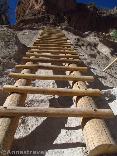
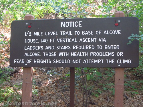
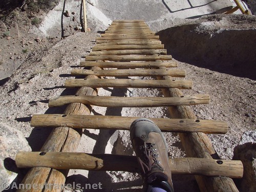
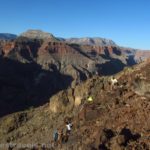
Probably one of my favorite hikes in Bandelier is Alcove House. One of the great things is that it’s not that much longer to take the Main Loop to the Alcove House Trail, so you get to see the cliff dwellings on the way. Another great thing – to me – and the reason I love the trail – is because you have to climb a long series of ladders to get up to the alcove. Maybe it’s the child in me, but it makes a trail very unique and special to climb 140 feet using four wooden ladders and a narrow, twisting trail along the cliff!
Quick Stats
The trail begins behind the visitor center. After 0.1 mile, stay right toward “Main Loop, Long House, Cliff Dwellings”. Pass by a few kivas and the remains of a pueblo. About 0.4 miles from the visitor center, you have a choice: Turn right to take the Main Loop up past the cliff dwellings (my recommendation; about a half mile longer) or take the right trail for a smoother, flatter, shorter walk.
Either way, you’ll want to end up at the trail junction that points toward Alcove House. If you’re coming from the Main Loop, this will be turning right; if you took the lower trail, continue straight.
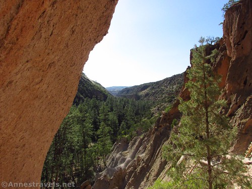
The trail is very flat, passing through stands of pines. At the two trail junctions, continue toward Alcove House on the trail mostly on the northeast side of the river / streambed. Along the way is a primitive restroom.
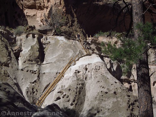
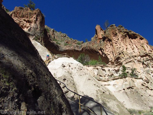
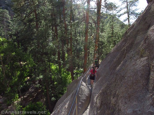
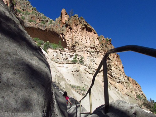
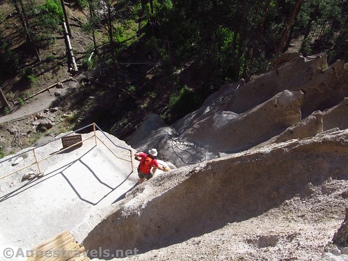
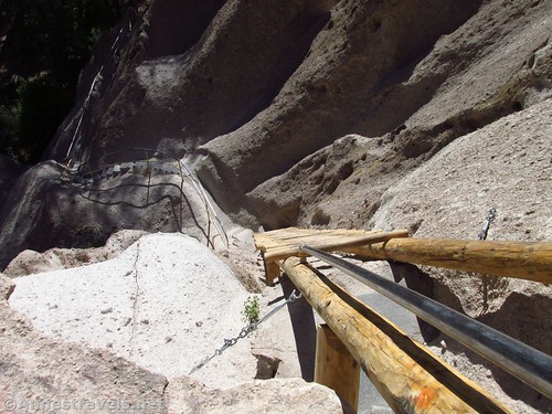
After about a half mile, arrive at the cliff face. A sign will warn of the route ahead; if you’re not fond of heights, you might want to skip the rest of the trail. There are plenty of railings, so it’s quite safe, but it might not feel that way. If you decide to proceed, begin climbing the ladders.
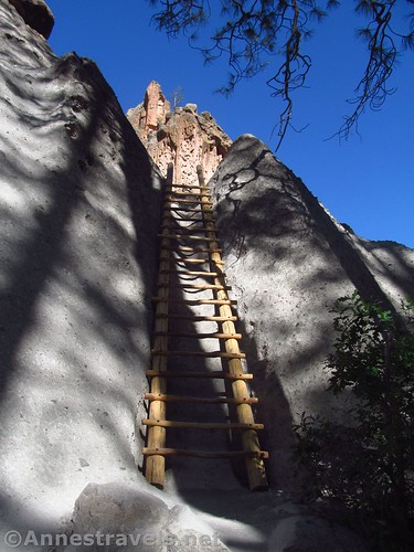
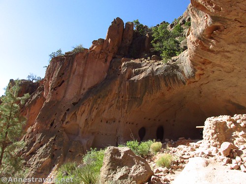
It’s about 0.2 miles up the ladders – and 140 feet vertically – to the alcove. There are ladders and twisting walkways, but if the park service felt a railing was necessary, there is one installed. I was grateful for the railings in a few places, especially while passing other hikers.
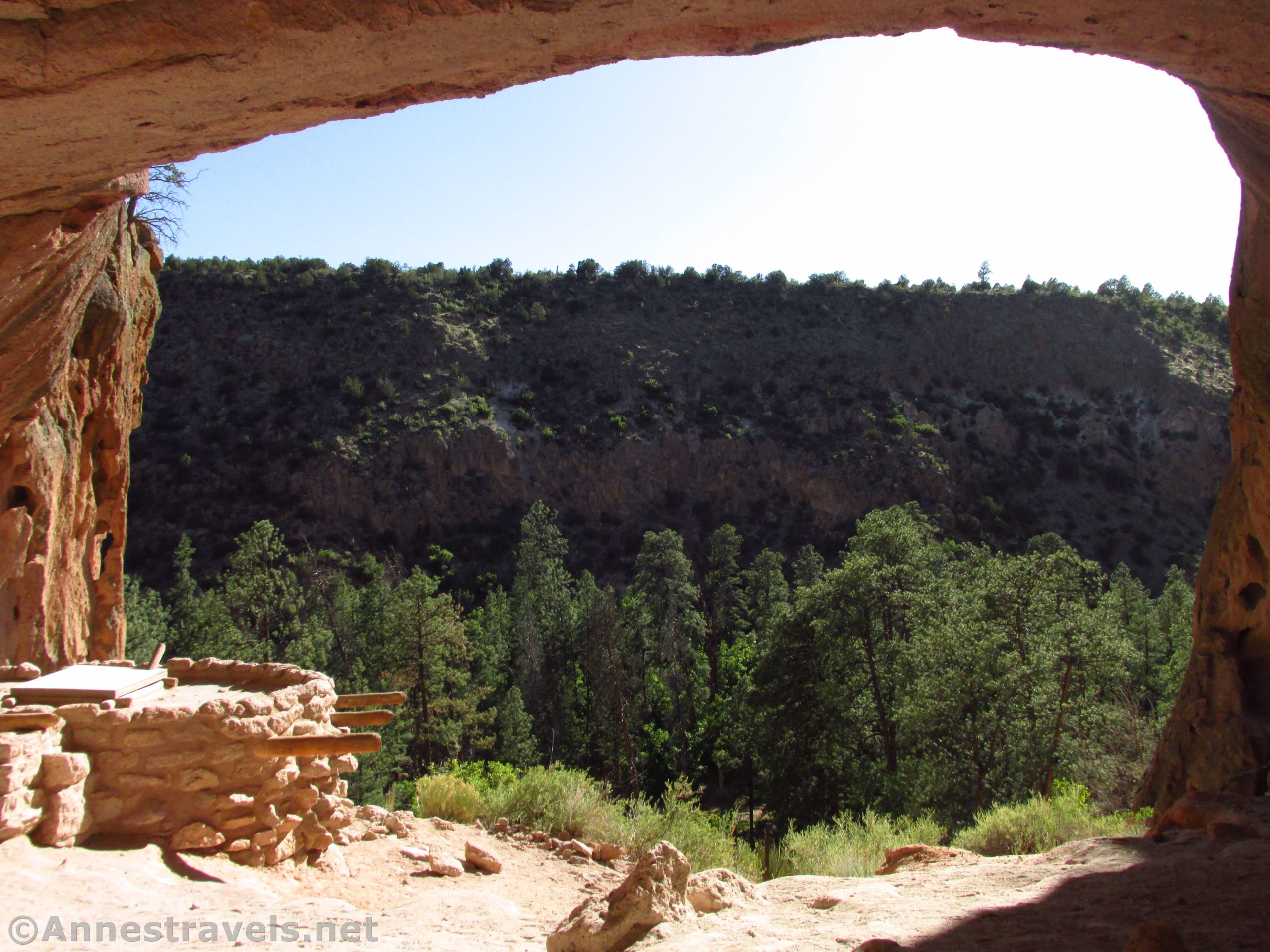
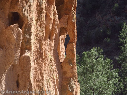
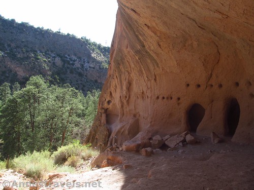
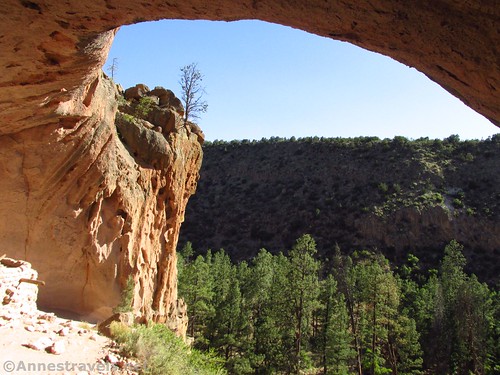
Once in the alcove, stroll over toward the right end to look at the reconstructed kiva and the holes marking where there were once structures. You can’t go inside the kiva, but it’s cool that someone made a structure like this up here. Something tells me the Ancient Puebloans didn’t have railings on their route up to the alcove!
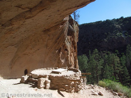
Also keep an eye on the cliffs around the alcove – there’s at least one tiny arch.
After enjoying Alcove House for a bit, come back down. We returned via the trail on the southwestern side of the riverbed – we met up with the park road less than a mile later and then I crossed over via the loop trail back to the visitor center. If you parked near the picnic area, you can just keep walking along the road back to the parking area.
Overall, Alcove House itself may or may not be exciting to you, but the trail to get there is definitely worth the trek!
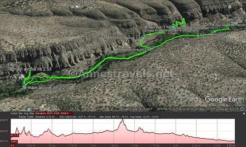
Round Trip Trail Length: My GPS was reading 4.75 by the time we got back, but due to some satellite reception, I’d guess it’s closer to 3.1 miles
Elevation Change: My GPS said 282ft. (6,033 at the trailhead to 6,315ft. in Alcove House)
Facilities: Visitor services, snack bar, restrooms, etc. at the visitor center. Primitive toilet along the trail to Alcove House.
Fees: $25/vehicle, valid 7 days. National Parks & Federal Lands Passes and Bandelier Annual Passes also accepted.
Trail Notes: This is not a trail for those with a fear of heights. That said, one of my group members who hates heights did this without too much issue (the other who dislikes heights decided not to climb, but I think he just didn’t want to hike any further and it had very little to do with ladders or heights).
Trail 
![]()
![]()
Road ![]()
Signs ![]()
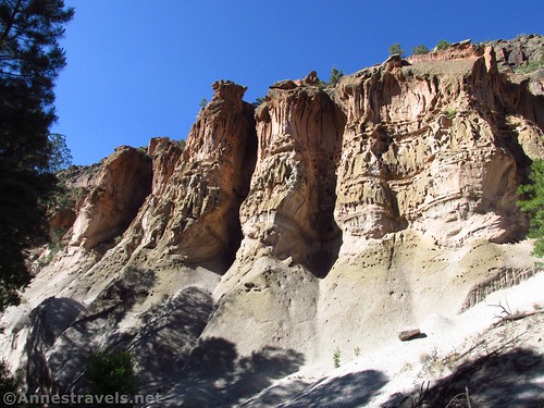
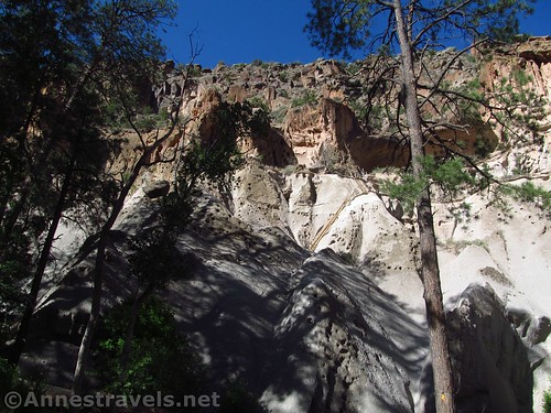
Scenery ![]()
![]()
Would I go 100 miles out of my way for this? ![]()
![]()
Overall Rating: 
![]()
GPS Coordinates for Alcove House
Note: All mileages reflect doing the main loop as well as Alcove House and due to a few satellite reception issues, the actual distances may be slightly less than stated.
Trailhead behind the visitor center: 35.7792333°, -106.2711500° (N35° 46.754′ W106° 16.269′ / 5°46’45.2400″, -106°16’16.1400″) (6,033ft.) (0.0) (end 4.75)
Main Loop Trail Junction #1: 35.7806833°, -106.2725667° (N35° 46.841′ W106° 16.354′ / 35°46’50.4600″, -106°16’21.2400″)(6,045ft.) (0.16)
Main Loop Trail Junction #2: 35.7826000°, -106.2741667° (N35° 46.956′ W106° 16.450′ / 35°46’57.3600″, -106°16’27.0000″) (6,087ft.) (0.39)
Alcove Junction #1: 35.7837500°, -106.2784833° (N35° 47.025′ W106° 16.709′ / 35°47’01.5000″, -106°16’42.5400″) (6,130ft.) (1.68)
Alcove Junction #2: 35.7886000°, -106.2860333° (N35° 47.316′ W106° 17.162′ / 35°47’18.9600″, -106°17’09.7200″) (6,180ft.) (2.34)
Alcove: 35.7887833°, -106.2849833° (N35° 47.327′ W106° 17.099′ / 35°47’19.6200″, -106°17’05.9400″) (6,315ft.) (2.53)
Meet Road: 35.7805000°, -106.2735000° (N35° 46.830′ W106° 16.410′ / 35°46’49.8000″, -106°16’24.6000″) (6,082ft.) (4.52)
The gpx file for the Alcove House (along with the Main Loop) can be downloaded – please note that this and the GPS Coordinates are for reference only and should not be used as a sole resource when hiking this trail. Also note that the GPX begins at the second junction, not at the visitor center.
Download GPX File size: 78.2 KB Downloaded 568 times
(Note: I do my best to ensure that all downloads, the webpage, etc. are virus-free and accurate; however, I cannot be held responsible for any damage that might result, including but not limited to loss of data, damages to hardware, harm to users, from use of files, information, etc. from this website. Thanks!)
Getting to the Main Loop and Long House in Bandelier
From Los Alamos, the shortest route is also perhaps the most exciting: You’ll have to pass through land owned (and used!) by the US military. Most of the time, it just means passing through what looks to be a toll booth but is actually a security checkpoint. If you’re not suspicious, they’ll let you drive through with the warning not to stop and not to get out of your vehicle or trespass on military land. Pretty simple and straightforward. If you don’t want to do this – or it’s closed for security reasons – you can take the east route out of town
West Route from Los Alamos:
Take NM-501 W (aka Diamond Drive) west and south out of the city. Just after a hard turn of the road to the east, use the right two lanes to turn right to pass through the military security checkpoint. After 4.6 miles, turn left at the T onto NM-4 E (a sign shortly after turning will point toward Bandelier). After 5.9 miles, turn right into the entrance road for Bandelier National Monument; follow the entrance road down into the canyon and park across the stream / dry streambed from the visitor center.
East Route:
Take NM-502 E (aka E Road) out of Los Alamos. Take the ramp onto NM-4 heading for White Rock. Continue on NM-4 for about 12 miles; turn left onto the entrance road to Bandelier National Monument and follow the entrance road down into the canyon and park across the stream / dry streambed from the visitor center.
Zoom map out to browse nearby hikes & places of interest
This Week’s Featured Product!
If you’re looking for more hikes and trails near Bandelier, check out this guide. Written by the man who built many of the trails, it offers an insider’s guide to the trails around Los Alamos.


One response to “Climbing the Ladders to Alcove House”
[…] the trail to Alcove House (up all those fun […]