

It’s not every day you get to climb a wooden ladder into the home of ancient American Indians. Maybe in Mesa Verde, on an official tour, or another tour with a guide or park ranger standing close by. But on the Main Loop in Bandelier National Monument in central New Mexico, you can not only climb up into a cliff dwelling, but you can do it on your own self-guided tour, without any rangers telling you how long you can stay or what you can and can’t do (within reason – vandalism isn’t allowed, obviously!) The hike is as short as 1.75 miles RT, though I highly recommend hiking further to Alcove House if you have the time and stamina.
Quick Stats
(Affiliate links are present on this page.)
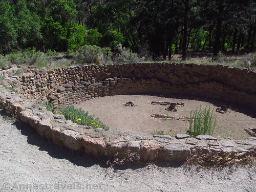
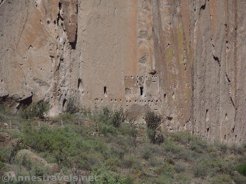
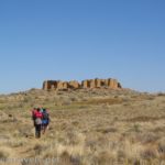
The path begins behind the visitor center near the beehive-shaped oven. Follow the paved pathway over even terrain to a trail junction at mile 0.1. Turn right, following the sign for “Main Loop, Long House, Cliff Dwellings”. Pass several kivas as well as the walls of other buildings that once made up a pueblo. Stay more or less on the path here; you can’t explore these, but you will be seeing them from above later on, which is better for getting a sense of scale.

Just after the pueblo, the trail splits again (mile 0.4). Again, you want to turn right, following the sign for “Main Ruins Loop, Cliff Dwellings”. Actually, this is the beginning of the loop, so you could go left, but you’ll be going against traffic, and the trail along the cliff is narrow enough that while it’s possible to pass people, it’s not optimal.
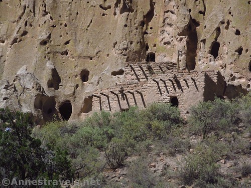
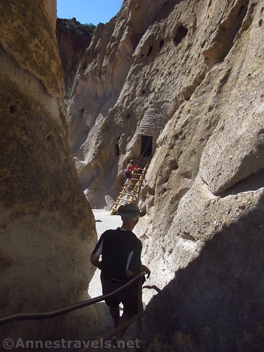
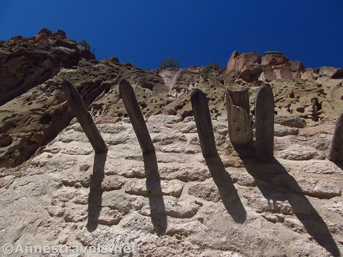
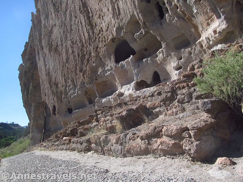
The trail continues to be paved, but the grade increases dramatically, looping back into a canyon in the cliffs, then climbing upward on sets of stairs. It then twists around to the front side of the cliffs, and bam! There’s a ladder leading up into a cliff dwelling!
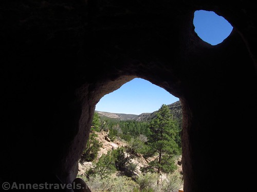
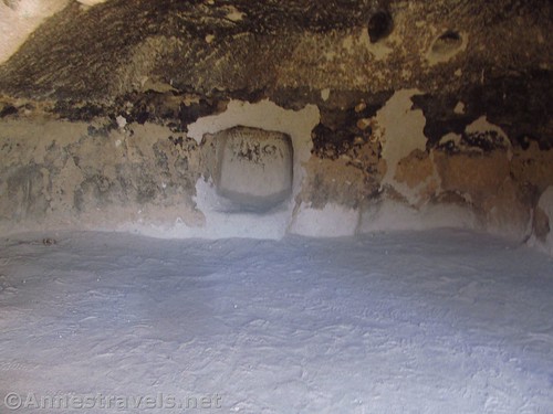
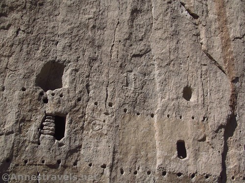
You can climb up into the hole in the cliff face. Whether these holes were used for storage, living quarters, defense, or just what is up for discussion. I just think it’s cool that we can be here, too.
Sometimes (mostly during popular seasons/time of day) a park ranger will be stationed at the bottom of the ladder to direct traffic. A June afternoon at 5pm isn’t exactly popular, so we and the other hikers politely let each other up and down the ladder. There is also a bench and wide area to wait your turn or look down on the pueblo below.
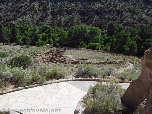
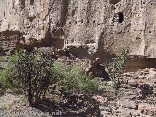
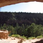
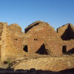
The trail continues along the cliff face (there are some tight spaces, but it’s not too bad for those with a fear of heights – my one group member who hates heights has hiked this trail at least four times without issue). Not too much further down the trail are some (reconstructed) pueblos along the base of the cliff, below more cliff dwellings (unfortunately, you can’t go into these, either, but plenty of people stick their heads through the windows).
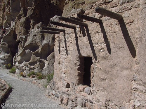
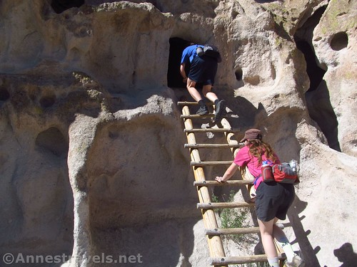
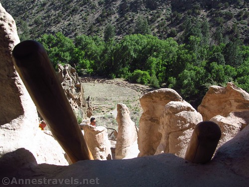
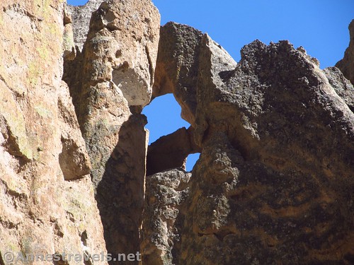
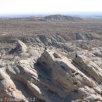
There are some interesting rock formations along the trail. But pretty soon you get to a longer ladder that leads up to another (better, per me) cliff dwelling. (There is a third ladder further down the trail). We have a long tradition of getting the kids (and former kids) in the group to stand on the ladder for photos. We also like to explore the rooms inside the cliff face – there’s room for a dozen or so people if they don’t mind being in close quarters.
Continue on to Long House. You can’t go in these, either, but there are some pictographs and petroglyphs, as well as ruined pueblos and caves in the cliff. I personally liked the cacti growing up through it all.
Turn left at the junction to descend back down into the valley; turn left at the next junction (at mile 1.35) to complete the loop back to the visitor center (about a half mile away). Or turn right to Alcove House – and climb up a series of very long ladders to an alcove high up on the cliffs – about a half a mile in the opposite direction, but definitely worth a post in its own right!
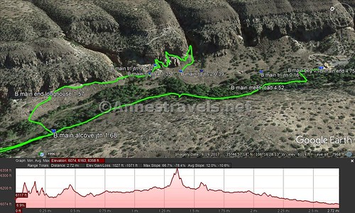
Round Trip Trail Distance: About 1.75 miles to take the loop
Net Elevation Change: 159ft. (6,074ft. at the Visitor Center to 6,224ft. high on the cliffs)
Facilities: Restrooms and visitor services at the visitor center at the trailhead
Fees: $25/vehicle, valid 7 days. National Parks & Federal Lands Passes and Bandelier Annual Passes also accepted.
Trail Notes: The trail is closed in the winter due to icy trails. During the summer season (May-October), a free shuttle bus is mandatory to get to the trailhead between the hours of 9AM and 3PM (we planned our visit to arrive after 3PM). See the National Park Site for more information about shuttle buses. The trail is very unique along the cliff edge, but it’s more or less perfectly safe. Yes, you’re high up, but unless you’re petrified by heights, you shouldn’t have any issue. Some parts are very narrow – one-way traffic, with each side sharing right-of-way. There are some mandatory stairs and a metal ladder or two, so it’s a fairly exciting easy hike.
Trail 
![]()
Road ![]()
Signs ![]()
Scenery ![]()
![]()
Would I go 100 miles out of my way for this? ![]()
Overall Rating: ![]()
GPS Coordinates for the Bandelier Main Loop
Trailhead behind the visitor center: 35.7792333°, -106.2711500° (N35° 46.754′ W106° 16.269′ / 5°46’45.2400″, -106°16’16.1400″) (6,033ft.) (0.0) (end 4.75)
Trail Junction: 35.7806833°, -106.2725667° (N35° 46.841′ W106° 16.354′ / 35°46’50.4600″, -106°16’21.2400″)(6,045ft.) (0.16)
Trail Junction #2: 35.7826000°, -106.2741667° (N35° 46.956′ W106° 16.450′ / 35°46’57.3600″, -106°16’27.0000″) (6,087ft.) (0.39)
Ladder: 35.7821167°, -106.2737333° (N35° 46.927′ W106° 16.424′ / 35°46’55.6200″, -106°16’25.4400″) (6,144ft.) (0.77)
Trail Junction #3: 35.7833000°, -106.2744667° (N35° 46.998′ W106° 16.468′ / 35°46’59.8800″, -106°16’28.0800″) (6,140ft.) (1.32)
Trail Junction #4: 35.7832500°, -106.2748667° (N35° 46.995′ W106° 16.492′ / 35°46’59.7000″, -106°16’29.5200″) (6,121ft.) (1.35)
End Longhouse Trail: 35.7847000°, -106.2775333° (N35° 47.082′ W106° 16.652′ / 35°47’04.9200″, -106°16’39.1200″) (6,172ft.) (1.57)
The gpx file for the Bandelier Main Loop (and Alcove House) can be downloaded – please note that this and the GPS Coordinates are for reference only and should not be used as a sole resource when hiking this trail. Also note that the GPX begins at the second junction, not at the visitor center.
Download GPX File size: 78.2 KB Downloaded 523 times
(Note: I do my best to ensure that all downloads, the webpage, etc. are virus-free and accurate; however, I cannot be held responsible for any damage that might result, including but not limited to loss of data, damages to hardware, harm to users, from use of files, information, etc. from this website. Thanks!)
Getting to the Main Loop and Long House in Bandelier
From Los Alamos, the shortest route is also perhaps the most exciting: You’ll have to pass through land owned (and used!) by the US military. Most of the time, it just means passing through what looks to be a toll booth but is actually a security checkpoint. If you’re not suspicious, they’ll let you drive through with the warning not to stop and not to get out of your vehicle or trespass on military land. Pretty simple and straightforward. If you don’t want to do this – or it’s closed for security reasons – you can take the east route out of town
West Route from Los Alamos:
Take NM-501 W (aka Diamond Drive) west and south out of the city. Just after a hard turn of the road to the east, use the right two lanes to turn right to pass through the military security checkpoint. After 4.6 miles, turn left at the T onto NM-4 E (a sign shortly after turning will point toward Bandelier). After 5.9 miles, turn right into the entrance road for Bandelier National Monument; follow the entrance road down into the canyon and park across the stream / dry streambed from the visitor center.
East Route:
Take NM-502 E (aka E Road) out of Los Alamos. Take the ramp onto NM-4 heading for White Rock. Continue on NM-4 for about 12 miles; turn left onto the entrance road to Bandelier National Monument and follow the entrance road down into the canyon and park across the stream / dry streambed from the visitor center.
Zoom map out to browse nearby hikes & places of interest
This Week’s Featured Product!
Looking for more easy day hikes in Bandelier National Monument and the surrounding area? Check out this guide detailing nearly 25 trails.

2 responses to “Climbing Ladders into Caves on Bandelier’s Main Loop”
[…] In the evening (they wouldn’t let us drive in until 3pm) we hiked a couple old favorite trails in Bandelier National Monument – the Main Loop… […]
[…] the remains of a pueblo. About 0.4 miles from the visitor center, you have a choice: Turn right to take the Main Loop up past the cliff dwellings (my recommendation; about a half mile longer) or take the right trail […]