
If you’re looking for one hike in the Uinta Mountains that will give you bang for buck, I’d highly recommend Bald Mountain. The scenery you drive through to get there is almost worth the visit, but once on the trail, the views are outstanding over valleys, mountain peaks, lakes, and so much more. The 360 view from the top is even more all-encompassing. It’s steep, but it’s only 3.2 miles RT!
Quick Stats
(Affiliate links are present on this page.)
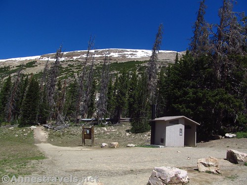
We almost didn’t hike Bald Mountain, because two weeks before (the latest information I could get), the USFS website said it was closed. But with few other options, we drove up to the trailhead, and it didn’t look closed. There weren’t any signs, or ropes, or even “caution” stickers. We could see some snow patches, but you’ll have that at 10,700 feet in early June.
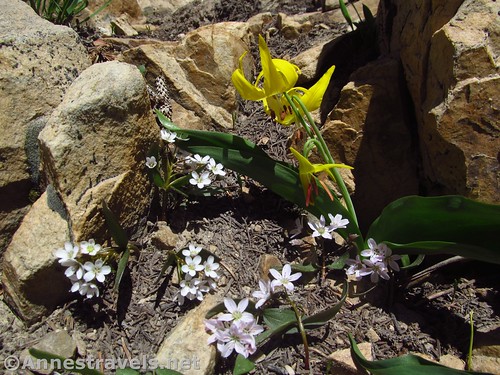
There are a couple advantages to hiking Bald Mountain this early in the season. The first is that you’re more likely to have the trail to yourself – I’d say from the trail that it’s pretty heavily used, but we only met three or four other groups, and we had the peak to ourselves. The second is that the bugs haven’t made it this high, so you’ll probably have a more pleasant hike. Third, there were a fair number of glacier lilies along the trail – it looked like the tundra-style wildflowers would emerge slightly later. Fourth, with snow still on the surrounding peaks, the views are even more epic!
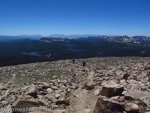
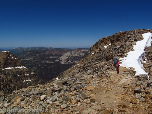
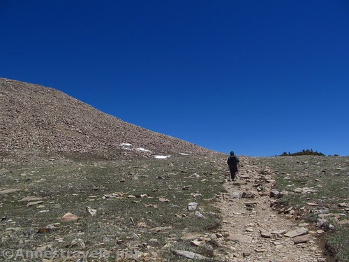
The trail climbs steeply from the first on the fairly wide dirt path (stay on the trail to Bald Mountain shortly after the trailhead rather than the less-used path down into the valley). It passes upward through rocks and stunted firs, then into more open rocky hillside. It’s not hard to follow, though it is very steep.
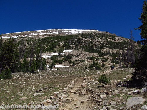
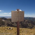
A sign points toward Bald Mountain, stating that the peak is in 2 miles. I found it to be about a half mile less than that, and while I did lose the trail a couple times due to snow, I don’t think following the trail in those sections would have been even close to a half mile longer.
We ran into our first (of three) snowfields in a very rocky section maybe three quarters of a mile from the trailhead. We dropped below the snow onto the scree, then scrambled back up to the trail. Plenty of people had done it before us, both this year and in years prior to our visit.
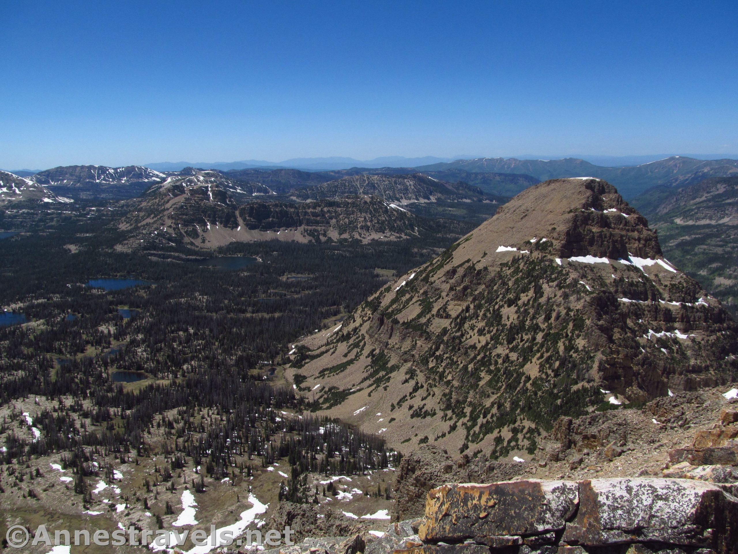
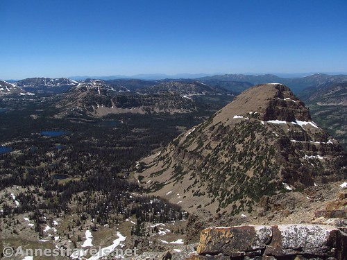
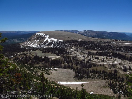
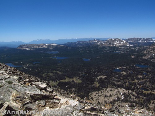
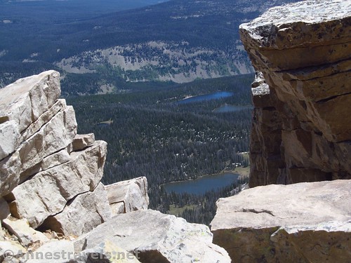
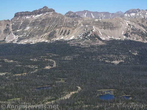
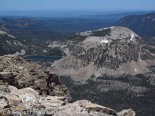
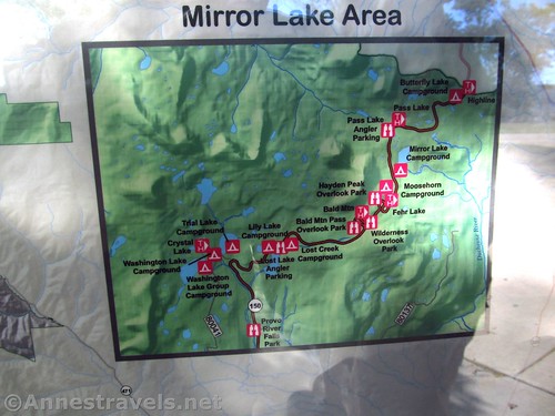
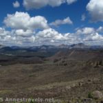
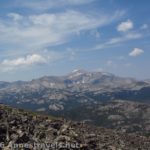
After this, the trail, which has been generally working its way westward, turns north through a band of trees. This was our second snowfield, but it was short enough to not lose the trail. The path turns eastward to traverse beautiful alpine tundra meadows. The views are great toward Mount Watson, as well as the basins containing Wall Lake, Star Lake, Trail Lake, Washington Lake, Lost Lake, and many more.
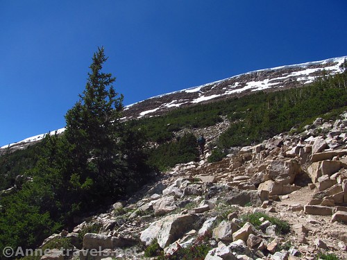
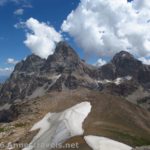
At nearly the far end of Bald Mountain, the trail turns again to the north. Here we encountered our third (and most difficult) snowfield. Those before us had climbed the snow in a generally straight line, so we did that, too, on our way up. From above the snow, we could see that the trail actually ascended up the eastern side of the peak in long switchbacks, so we took that on the way down. There was also some snow on the final push up the peak, and so we took to the scree. It was relatively stable.
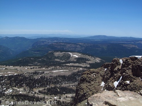
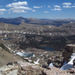
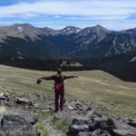
Once on top of the peak, the trail more or less disappears in a pile of rocks and scree. But you don’t need a trail to enjoy the 360 views. It’s so idyllic, so incredibly jaw-dropping. Every way you look, there are mountains and lakes and green forests. No wonder this place is popular with the locals in Salt Lake City!
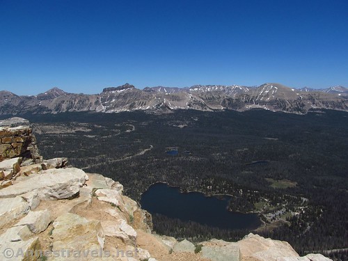
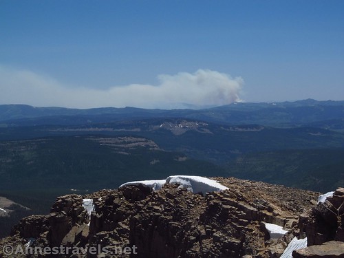
There are especially good views of Moosehorn Lake and Mirror Lake to the east, along with views to the ridge containing Mt. Agassiz across Mirror Lake (to the northeast), Kamas Lake and Mt. Marsell to the north, Reids Peak and Notch, Dean, and Clegg Lakes below Notch Mountain to the west, Mount Watson, Wall Lake, Trail Lake, Washington Lake and Lost Lake to the southwest, and Murdock Mountain, on the other side of Bald Mountain Pass, to the south. Also to the south, we could see smoke from the Strawberry Reservoir fire.
We sat and drank in the view for as long as we thought we could, considering the trek back down and then finding a campsite for the night (we hadn’t exactly gotten an early start, since we had driven in from Provo that morning). But oh, what a view! It was our introduction to the Uinta Mountains, and while we would do two more hikes in the area (Ibantik Lake and Mt. Agassiz), this really is the crowning glory of the three – short, steep, but with views to rival most other peaks (which often don’t have trails up them anyway).

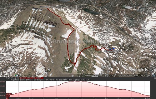
Round Trip Length: 3.2 miles (out & back)
Elevation Change: 1,153ft. (10,750ft. at the parking area to 11,903ft. atop Bald Mountain)
Facilities: Primitive restroom and a few picnic tables at the trailhead
Pets or Horses: Yes and Yes; pets are allowed off-leash
Fees: $6/3 days to park and hike along the Mirror Lake Highway (which this is); National Park & Federal Lands Passes accepted
Trail Notes: The trail is short, but it is steep, especially the first and final sections. Also, be wary of snowfields early in the season. There are no railings on the summit, and the drops are worse than sheer – use cation near the edges!
Trail 
![]()
![]()
Road ![]()
Signs ![]()
![]()
Scenery
Would I go 100 miles out of my way for this?
Overall Rating: ![]()
Key GPS Coordinates for Bald Mountain
Trailhead: 40.6892000°, -110.9041333° (N40° 41.352′, W110° 54.248′ / 40°41’21.1200″, -110°54’14.8800″) (10,750ft.) (0.0) (end 3.22)
Trail Junction: 40.6894833°, -110.9044333° (N40° 41.369′ W110° 54.266′ / 40°41’22.1400″, -110°54’15.9600″) (10,762ft.) (175ft.)
Bald Mountain Peak: 40.6989167°, -110.9031500° (N40° 41.935′ W110° 54.189′ / 40°41’56.1000″, -110°54’11.3400″) (11,903ft.) (1.58)
The gpx file for the trail up Bald Mountain can be downloaded – please note that this and the GPS Coordinates are for reference only and should not be used as a sole resource when hiking this trail.
Download GPX File size: 99.7 KB Downloaded 395 times
(Note: I do my best to ensure that all downloads, the webpage, etc. are virus-free and accurate; however, I cannot be held responsible for any damage that might result, including but not limited to loss of data, damages to hardware, harm to users, from use of files, information, etc. from this website. Thanks!)
Getting to Bald Mountain
From I-80E, east of Salt Lake City, take Exit 146 toward US-40 East toward Heber City and Vernal. After 0.7 miles continue on US-189 / US-40E for another 0.3 miles. Take Exit 4 toward Park City and Kamas; turn left onto UT-248E. After 11.4 miles, turn left onto UT-32 (there’s a 7-Eleven on the corner); only 0.2 miles later, turn right onto UT-150 (next to the Chevron). A ranger station is nearby if you need information – by some fluke, it was closed for staff training the day we tried to visit. Continue on UT-150 for 29 miles to the top of Bald Mountain Pass. Here, turn left into the trailhead parking for Bald Mountain. If you’re looking for a short side-trip, Upper Provo Falls is a great stop (I wanted to do it, but we didn’t have time that day).
From I-80W (west of Evanston, Wyoming), take Exit 5 in Evanston toward UT-150. Turn left onto WY-150, also known as Front Street. After 22.6 miles, the road will change names to UT-150. Continue to drive up into the mountains for another 25.6 miles to the top of Bald Mountain Pass. Turn right into the trailhead parking for Bald Mountain.
Zoom map out to browse nearby hikes & places of interest
This Week’s Featured Product!
Looking for more hikes in the greater Salt Lake City area? Most of these can be done as day trips or weekend treks from Salt Lake City, including a few hikes in the Uinta Mountains.
2 responses to “Early Season Hiking on Bald Mountain”
[…] wildflowers on Bald Mountain in the Uinta Mountains of […]
[…] trail up Bald Mountain certainly had a little snow, but it was easily negotiated. And the views. Oh, […]