

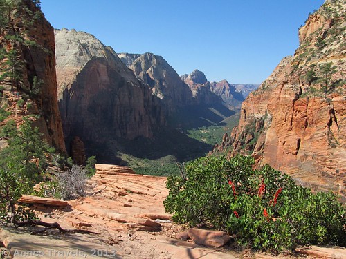
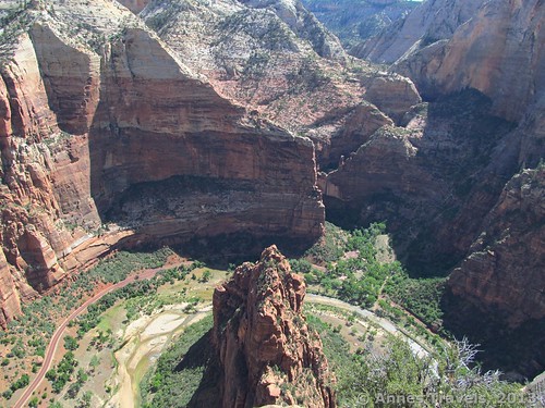
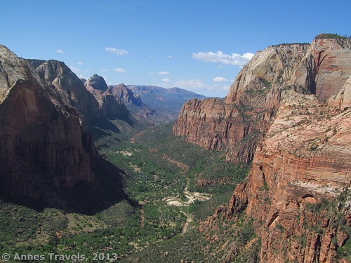
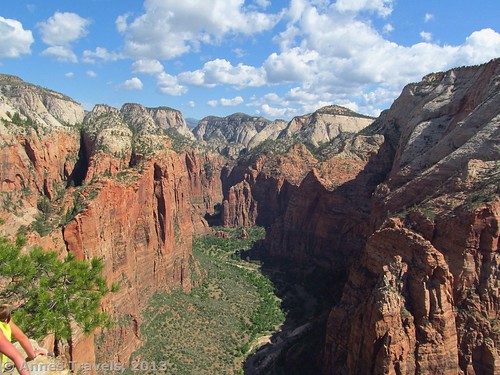
Ok, so I’ll admit it: I’ve never been fond of Zion National Park. Every time I’ve visited since 1997 it seemed there was nothing to do that got you far enough away from Zion Canyon to allow you to appreciate it. I’ve even discouraged others from visiting, saying there are better parks in the area (Bryce Canyon, for example). However, at the suggestion of a friend I decided to give Zion another try by taking the Angel’s Landing Trail. It trail sounded cool: chains, railings, moki steps, and narrow ledges with 1,200 foot drop-offs right next to you. I’m very glad I did the trail, not only because it was very exhilarating (I’d call it the most dangerous trail I’ve ever done (yes, more dangerous than the Causeway)), but because for strong-hearted hikers it offered some of the best views I’ve ever seen of Zion Canyon. Oh, and by the way, you don’t have to go all the way to the top of the Landing to see the views: even going half way up the last 0.5 miles (0.8 km) of the 5 mile (8 km) (RT) trail will give you views of Zion Canyon I’d never even imagined!
(Affiliate links are present on this page.)
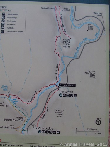
We drove into the park early Saturday morning, ate breakfast at the picnic tables in the parking area “near” the visitor center. (Actually, we parked at the far end of the visitor center’s parking (across from the campground), which was where we found the picnic tables). You’ll want to get a parking place early, as the lots fill up quickly and there really is no other place to park to ride the shuttle. The NPS talks about more parking in Springdale, but these are little more than gravel areas on the edge of the road that might accommodate 10 cars each. So, park early, be happy. Breakfast accomplished and packs in hand, we walked over to the visitor center where the shuttle busses leave for Zion Canyon. Our stop would be The Grotto, the fourth-to-last stop on the shuttle route. This shuttle is mandatory; no cars are allowed in Zion Canyon except those whose occupants are staying at the Zion Lodge.
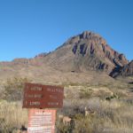
A recorded voice talks nearly the entire way down the canyon. I tired of it quickly and enjoyed the scenery instead. Nearer to the end of the talk, however, the information was more interesting and I enjoyed learning about the history of the canyon (it helped that I likely knew the Bible better than the narrator, so the descriptions of how various formations got their names from early Morman settlers was fun). At last we reached the Grotto shuttle stop, hopped off, and used the restrooms one last time before heading up the trail. A water spicket is also available. The trail begins across the road from the shuttle stop, near the sign about Angel’s Landing. Cross the bridge, then take an almost immediate right turn to follow the West Rim Trail toward Angel’s Landing. A sign marks this junction.
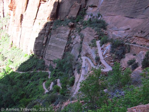
For a bit, the trail was paved, then the pavement began to break up and became dirt/stone. The sun was already on the trial, but it wasn’t too hot yet. From almost the beginning, the trail switchbacks, but before too long we came to the real switchbacks, known as “Walter’s Wiggles”. This steep series of switchbacks was in shade, but they would be grueling only an hour or so later once they came into the sun’s light. We kept pausing as we climbed to take pictures of the wiggles below us. The trail’s surface here is mainly rock cobbles, and walls separate you from the edge of the dropoff.
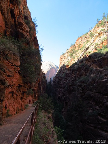
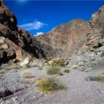
The trail finally turns away from the Wiggles to enter Refrigerator Canyon, high on the side of Zion Canyon. This part of the trail tends to be cool at any time of day and a welcome reprieve from the heat of the rest of the trail. It also tends to be peaceful, with trees and a small stream flowing below the trail. A sign requested visitors to be quiet for the sake of the wildlife in the canyon; however, I have to wonder if far too many people use it as “Echo Canyon” instead of “Refrigerator Canyon”.
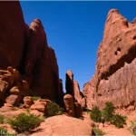
After passing through Refrigerator Canyon, the trail climbs its side via a series of switchbacks. These were fun, simply because there are so many layers of switchbacks on top of one another and it’s enjoyable to look down on the rest of the party below you. The brick reminded me of Wall Street in Bryce Canyon.
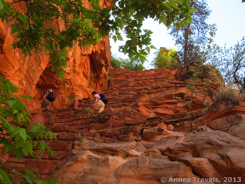
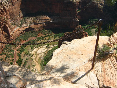
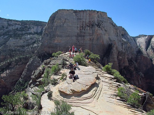
Very quickly after these switchbacks, and about 2 miles (3.2 km) from the shuttle stop, the West Rim Trail, which you’ve been following, intersects the Angel’s Landing Trail. Turn right at this junction. It may not be very easy to figure out which way is right because the junction area is so large and sandy. Apparently many people stop here – or a few yards (meters) down the Angel’s Landing Trail – because they don’t want to traverse the last 0.5 miles (0.8 km) to the top. I can’t blame them. The trail is nerve racking, even terrifying at times. You will be walking along a “trail” that is sometimes less than two feet (60 cm) wide with only iron chains to help you scramble/keep you from the edge. Dropoffs of over 1,000 feet (300 m) are common. Sometimes there are chain “railings” to keep you from going over the edge, but usually it’s just thin air. Occasionally steps have been chipped into the rock (or the rock makes a natural staircase), and sometimes you will be walking or scrambling on slickrock. Add to this that you will likely meet people going in the opposite direction who you will have to pass in “wide” sections (or at least places where you can press yourself against the rock and let them inch past you). I’m not trying to dissuade you, but I am trying to give you a taste of what you will see at times along the way (though not constantly, thankfully!)
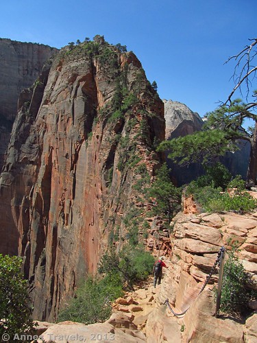
About ¼ of the way up, you will come to what seems to be the end of the trail/top of the landing. This is actually not the end; the trail continues next to the dropoff on the left. However, many people do not go further from this because they see what’s coming. It’s actually not as bad as it looks from here, but also remember that I’ve done quite a bit of bouldering (no rock climbing experience, though). The views from here are quite nice, though they are better at the top. Keep scrambling/climbing. About 2/3 of the way up, there is a nice, wide plateau section under a spreading tree. This is shady, but it also offers nice views and a place to rest while getting out of the main traffic flow. We ate lunch here on the way back down and weren’t in anyone’s way – a good thing, with the number of other climbers!
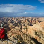
Then, finally, we reached the last stretch, where the grand levels off and the chains disappear. Pass a couple trees, then there will be a monolith of rock on your right. This appears to be the highest point on Angel’s Landing. However, for the best views, keep going a short ways further to where the rock begins to slope downward. This is also where most of the hikers hang out, though some prefer the relative safety of the rock just before the slope.
Retrace your steps back to the Grotto shuttle stop. Although a relatively precarious hike, it’s also exhilarating and, if done carefully, not as dangerous as it looks and sounds. Would I do it again? Maybe. Am I glad I did it? A resounding Yes!!!
Note #1: Young children should not attempt the trail at all, and neither should adults who don’t like heights. Even months earlier I’d have never let the two youngest members of our party do it – but now I thought they could handle it (they did fine with constant, direct supervision). The youngest doesn’t like heights and was terrified the entire time, which helped a lot (though I don’t think the person helping him climb would agree with this!)
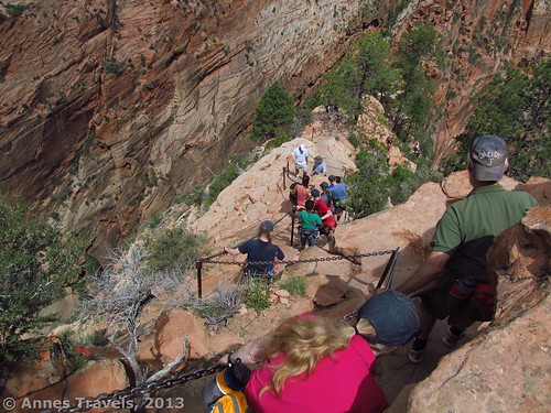
Note #2: Do yourself a favor and don’t try this hike during the busy season at Zion. If you have to do it during the busy season, take the first possible shuttle to the Grotto. We visited on a Saturday in May and were extremely thankful we’d taken the second or third shuttle. The trail up was relatively calm; there were plenty of people, but not an overwhelming number. Coming back down the Angel’s Landing Trail was nearly impossible; hundreds of other visitors were coming up the Landing and we had to let the greater mass pass us. Finally we made a push for it and all got down just so we’d stop being a hazard to ourselves and others. I’d highly recommend doing this in a less-busy season.
Round Trip Trail Length: 5 miles (8 km)
Elevation Gain: About 1,400 feet (425 m)
Facilities: Water at the trailhead, real restrooms at the beginning of the trail, primitive restrooms at the West Rim Trail/Angel’s Land Trail Junction
Fees: $25 fee to enter Zion National Park, valid 7 days. America the Beautiful (Interagency), Senior (Golden Age), Access (Golden Access), Volunteer, Military, and Zion Annual Passes also accepted.
Trail 
![]()
![]()
![]()
Road
Signs ![]()
Scenery
Would I go 100 miles out of my way for this?
Overall Rating: ![]()
Getting to Angel’s Landing
Park at the Zion Visitor Center. There are several large parking areas here; park and then come back to the visitor center. From the visitor center entrance, walk toward the main road and the driveway that brought you off of the main roads and into the visitor center area. There is a shuttle stop here. Get on the shuttle and stay on until you come to The Grotto. Get off the shuttle, cross the road, find the bridge, and you will be on the trail to Angel’s Landing. Note: make sure you’re on the shuttle for Zion Canyon and not the shuttle for Springdale. There are two different shuttle stops, but make sure before you ride 🙂
Key GPS Coordinates for Angel’s Landing
Beginning of the Angel’s Landing Trail: 37.25927N / 112.95135W (37° 15′ 33.372″N / 112° 57′ 4.86″W)
West Rim Trail Junction: 37.26000N / 112.95146W (37° 15′ 35.9994″N / 112° 57′ 5.2554″W)
West Rim Trail/Angel’s Landing Trail Junction: 37.27492N / 112.95082W (37° 16′ 29.712″N / 112° 57′ 2.9514″W)
Great views/lunch break 2/3 way up Angel’s Landing: 37.27049N / 112.94945W (37° 16′ 13.764″N / 112° 56′ 58.0194″W)
Top of Angel’s Landing/Trail End: 37.26936N / 112.94804W (37° 16′ 9.6954″N / 112° 56′ 52.944″W)
The gpx file for the trail to Angel’s Landing can be downloaded (I believe the file is only one-way; from top to bottom).
Download GPS File File size: 66.2 KB Downloaded 515 times
(Note: I do my best to ensure that all downloads, the webpage, etc. are virus-free and accurate; however, I cannot be held responsible for any damage that might result, including but not limited to loss of data, damages to hardware, harm to users, from use of files, information, etc. from this website. Thanks!)
This Week’s Featured Product!
Looking for more hikes in the Zion National Park region? This book offers a look at trails in Zion, Bryce Canyon, and Cedar Breaks National Parks. It is strictly a hiking book, which means you won’t have to peruse over where to eat and stay to find the information about trails.


6 responses to “Angel’s Landing: Best Views in Zion National Park”
It is a nice and helpful piece of information. I’m happy that you just shared this helpful information with us. Please keep us informed like this. Thanks for sharing.
Hi Anne – this sounds like a thrilling hike. If I’m ever down that way I’ll check it out.
Thanks for the read.
Loved this hike and agree with all the writer mentioned.
If you’re looking for something more secluded, get a back country permit and hike the 16 mi. down-river Virgin River hike. This is different from the Virgin River hike that begins in the park. You must take a van to the trailhead that is not in the park early in the morning. Then you hike 16 miles down the river. The first 12 miles are very secluded (we saw three people during the busy season in early June). The last 4 miles you will begin to see more people as this is a popular in-park hike in which people hike from the bottom up. But by that time we were so tired and it was so late (getting close to dark) that we actually appreciated getting back to civilization.
Cristi, sounds like a great hike! I’d love to check it out myself next time I’m in the area. ~Anne
[…] Angel’s Landing, Zion National Park […]
[…] 2-3 hours to Zion National Park. Climb Angel’s Landing (5 miles RT) for terrific views of Zion Canyon. If you don’t like heights, stop at the […]