

I love Bryce Canyon National Park. Somehow, I just can’t resist creamsicle-colored hoodoos sticking straight up toward the deep blue sky, especially when I’m hiking among the spires. However, the park isn’t that large, and the areas with the hoodoos is even smaller, so I guess it isn’t surprising that there aren’t many long hikes among the spires – the only really long trail is the 8 mile (12.8 km) Fairyland Trail. (OK, I’m not being quite fair; the Peek-a-Boo Loop is 5.5 miles (8.8 km) plus the mileage to get to the loop, but you get the point.) I’d read about the Fairyland Trail, but since the clouds rolled in before we could get to it the first time we planned to hike it, we made a special trip to Bryce the last time we visited Utah just to hike that trail. It was well worth the extra miles of driving, too, with beautiful spires, hoodoos, walls, and even arches along the trail that left us breathless.
Quick Stats
(Affiliate links are present on this page.)
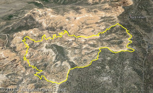
The Fairyland Trail is basically a loop trail, with the ends connected via the Rim Trail. We parked in the North Campground and hiked the Rim Trail first, but you could also start at Fairyland Point and have a flat trail at the end of your hike. We also hiked the loop clockwise, which offered us some very good views in the middle and beginning of the Fairyland Trail; going counter-clockwise also has its advantages (especially on the trek down into the hoodoos), so I can’t really say which is better.
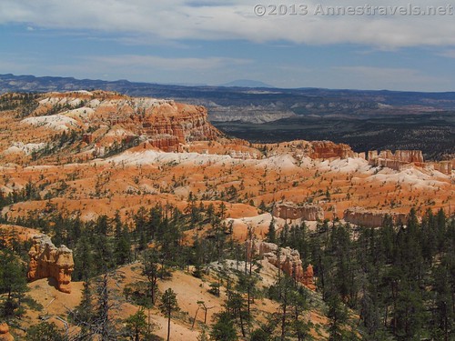
After parking in the day-use parking area in the North Campground early one morning in mid-May (Bryce isn’t too hot in May because of its elevation above the more popular parks such as Zion), we set out left down the Rim Trail. Less than ¼ mile into the hike, we all realized we didn’t want our extra jackets, so some of us walked back, dropped off the coats, picked up something we’d forgotten, and were on the trail again quite quickly. The rest of the hikers, however, weren’t having a bad time of it waiting for us: the Rim Trail has views galore of many spires from above. In the early morning light, the hoodoos seemed to glow orange, gold, and white in an almost surreal way.
The Rim Trail generally follows the edge of the canyon for about a mile (1.6 km) after the campground before reaching Fairyland Point. This section of the trail is quite flat and dirt, so the going is fairly easy. Early in the morning, this section of the trail was quiet and deserted, which was very nice; later it can become busy. At Fairyland Point, turn right to begin the descent into Bryce Canyon. This junction is extremely well-marked, so it would be difficult to miss. Pause for a moment at the trail junction to enjoy the view; it’s quite nice.
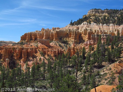
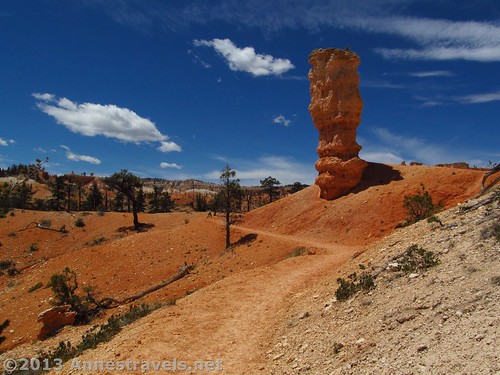
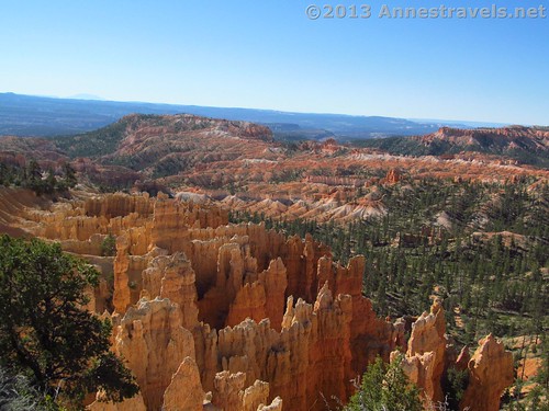
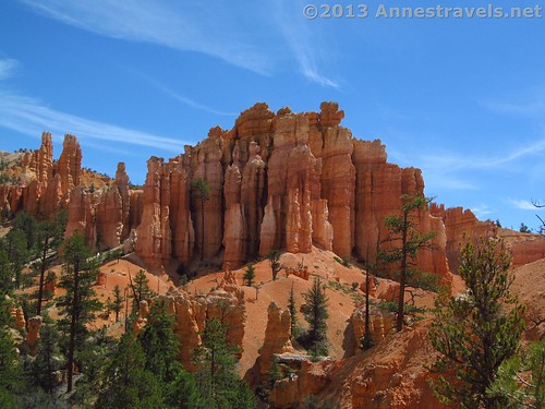
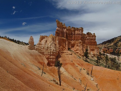
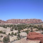
The Fairyland Trail immediately begins a steep descent into Bryce Canyon down a badland-surface-like trail. The views also open up dramatically from the first. All around us were hoodoos, spires, and walls of eroded orange-and-cream-colored rock. Wow! As the trail lost elevation, we found ourselves first level with the tops of the formations, then looking up at them. Before too long, we were walking around the bases of the spires as the trail wound its way among them. In the pictures, there are quite a few trees; however, these did not impact the view very much. If anything, the greenery added a nice contrast to the yellows and oranges of the rock (and that coming from an Easterner who certainly doesn’t travel out west to see trees!)
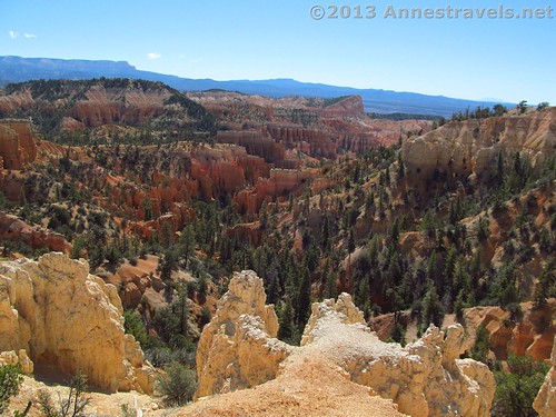
After walking around the spires for a bit, the trail turns to go through the canyon proper. It passes by some incredible views of the spires, then begins a slow ascent over several hills, with more spire views. The further we walked, the more “above the spires” rather than “in the spires” views we discovered. On and on the trail winds, with new views around every corner. It’s a place to just wander, enjoying the uniqueness of it all.
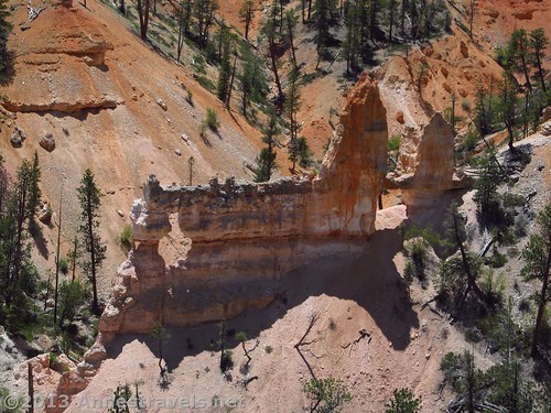
Just before the 4 mile (6.4 km) point (measured from Fairyland Point) the trail hugs the edge of a large badland as it descends into a creek bottom. From this part of the trail, we got a very good view of Tower Bridge, a formation with an arch that does look remarkably like its British counterpart. This is the best view you’ll get of the formation, so you might want to take your pictures now. At the creek bottom (and the 4 mile (6.4 km) point) a side-trail leads left to a viewing area for Tower Bridge. At only 200 yards (180 m), it’s probably worth the side-trek, although the views aren’t as good as from above.
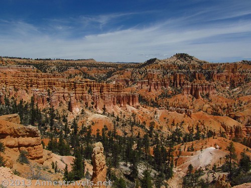
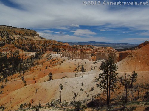
From the creek-bottom, the trail begins a slow but steady climb back up to the rim of Bryce Canyon. The views here are different than the descent area, and even slightly different than what you’ve seen before on the trail. There are more wide-open spaces between the walls of spires, and a more wind-swept look. I loved it, but it was definitely a different flavor than the sheltered forest of the side canyon the Fairyland Trail descends through.
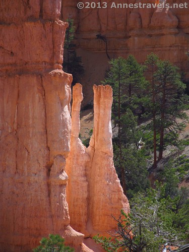
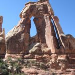
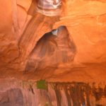
At one point, the trail hugs the side of a wall, then makes a sharp turn to go around the other side of the wall. Here there is a really cool little window, with some fun photo opportunities.
Finally, 5.5 miles (8.8 km) after Fairyland Point, the Fairyland Trail ends at the Rim Trail. Turn right here to walk the last approximately 0.5 miles (0.8 km) back to the North Campground. The Fairyland Trail Loop is a bit of a long trail, but it doesn’t feel that long because of all the nice scenery along the way. I’d highly recommend it to long-distance hikers and would do it again myself in a heartbeat!
Round Trip Trail Length: 8 miles (12.8 km); 8.25 miles (13.2 km) including the side-trip to Tower Bridge Viewpoint.
Starting Elevation: 7,811 ft. (2,380 m)
Highest Elevation: 8,122 ft. (2,475m)
Lowest Elevation: 7,162 ft. (2,183 m)
Facilities: Restrooms in the campground
Fees: $25 per vehicle to enter Bryce Canyon National Park, valid 7 days. America the Beautiful (Interagency), Senior (Golden Age), Access (Golden Access), Volunteer, Military, and Bryce Canyon Annual Passes also accepted.
Trail 
![]()
![]()
Road ![]()
Signs ![]()
Scenery
Would I go 100 miles out of my way for this?
Overall Rating: ![]()
Key GPS Coordinates for the Fairyland Trail Loop
Note: All coordinates without an elevation are approximate
Campground Day Use Parking Area: 37.63493N / -112.16546W (37° 38′ 5.7474″ / -112° 9′ 55.6554″ )(7,811ft.; 2,380 m)
Rim Trail Junction (Trail Beginning / End): 37.63490N / -112.16469W (37° 38′ 5.64″ / -112° 9′ 52.8834″) (7,951ft.; 2,423 m)
Fairyland Point Parking Area: 37.649412N / -112.147550W (37° 38′ 57.8826″ / -112° 8′ 51.1794″)
Rim Trail / Fairyland Trail Junction: 37.649318N / -112.147003W (37° 38′ 57.5448″ / -112° 8′ 49.2102″)
Twisting Trough the Spires (Where we ate lunch): 37.64367N / -112.13640W (37° 38′ 37.212″ / -112° 8′ 11.0394″) (7,252 ft.; 2,210 m)
Nice View (and movie) 1: 37.63886N / -112.13416W (37° 38′ 19.896″ / -112° 8′ 2.9754″) (7,267ft.; 2,215 m)
Nice View (and movie) 2: 37.63528N / -112.13877W (37° 38′ 7.008″ / -112° 8′ 19.5714″) (7,453ft.; 2,271 m)
Tower Bridge Trail Junction: 37.63339N / -112.14600W (37° 38′ 0.2034″ / -112° 8′ 45.6″) (7,229ft.; 2,203 m)
Tower Bridge Viewing Area: 37.632280N / -112.144780W (37° 37′ 56.208″ / -112° 8′ 41.2074″)
Fairyland Trail / Rim Trail Junction 2: 37.631902N / -112.162687W (37° 37′ 54.8466″ / -112° 9′ 45.6732″)
The gpx file for the Fairyland Trail can be downloaded – please note that this and the GPS Coordinates are for reference only and should not be used as a sole resource when hiking this trail.
Download File size: 166.0 KB Downloaded 640 times
(Note: I do my best to ensure that all downloads, the webpage, etc. are virus-free and accurate; however, I cannot be held responsible for any damage that might result, including but not limited to loss of data, damages to hardware, harm to users, from use of files, information, etc. from this website. Thanks!)
Getting to the Fairyland Trail Loop
From Kanab, UT, drive about 60 miles (95 km) north on US-89N. Turn right onto UT-12 E for 13.6 miles (21.8 km), then turn right again onto UT-63 for 3.9 miles (6.2 km). Follow the signs for Bryce Canyon National Park; it is well-marked. After 3.9 miles (6.2 km), turn left to enter the North Campground and locate the day-use parking area. This isn’t exactly well-marked, but keep looking and you’ll find it across from the picnic area.
Alternatively, from I-70, take Exit 23 onto US-89S. Drive about 67 miles (107 km), turning left to stay on US-89S after 60 miles (96 km). Turn left onto UT-12 E for 13.6 miles (21.8 km), then turn right again onto UT-63 for 3.9 miles (6.2 km). Follow the signs for Bryce Canyon National Park; it is well-marked. After 3.9 miles (6.2 km), turn left to enter the North Campground and locate the day-use parking area. This isn’t exactly well-marked, but keep looking and you’ll find it across from the picnic area.
This Week’s Featured Product!
Now with full-color pictures, this new edition of the classic hiking guide offers readers 60 hikes in southwestern Utah, including 13 trails within Bryce National Park.


2 responses to “Fairyland Trail Loop: A Long, Lovely Bryce Hike”
[…] Fairyland Trail, Bryce National Park […]
[…] the Fairyland Trail (8.25 miles) through the fantastically shaped, colorful spires of Bryce […]