

A highlight along the Oregon coast last summer would be exploring the area around Devil’s Punchbowl State Natural Area north of Newport. The area isn’t really that big, but low tide explorations are exciting (especially with the tide coming back in!) Think sea arches, tide pools, sea life, sea caves, a waterfall, and more. Then come back when the tide is in, and you can’t even access it all – it’s underwater – so you’ll just have to enjoy the surf from the headland above!
Quick Stats
(Affiliate links are present on this page.)
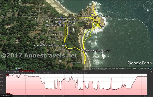
Park in the parking area for Devil’s Punchbowl, then walk down C Avenue (just west of the parking area). After passing 3rd Street, a path on left will descend to the beach, about 0.2 miles from the parking area.
It’s a little convoluted, and there aren’t exactly a lot of signs. We (and a bunch of other tourists – I think there were about 2 dozen of us at one point) got confused and descended the stairs across the street from the parking area. This goes down to a very nice beach (you can walk down to Beverly Beach and beyond, but that’s a subject for another post), and we tried walking around the headland using coordinates on my GPS, but that doesn’t work very well (unless you’ve got a boat!) So don’t get confused, and you’ll save a lot of time and effort.
Note: You can’t hike down to the beach unless the tide is out. Trying to descend when the tide is in is extremely dangerous, even fatal.
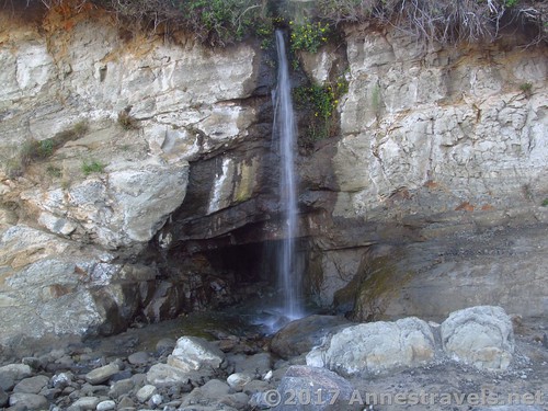
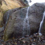
The trail is paved at first, but becomes sand at the bottom. Turn right to see a little waterfall, or turn left to get to the Punchbowl.
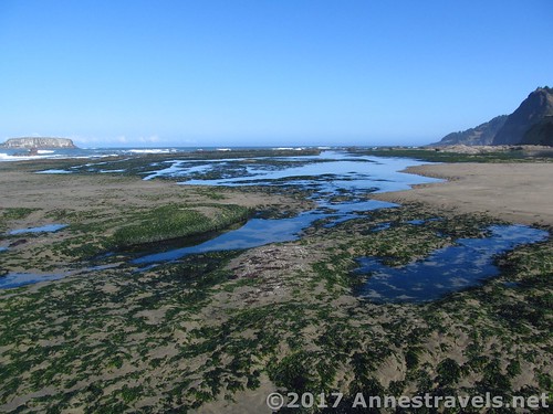
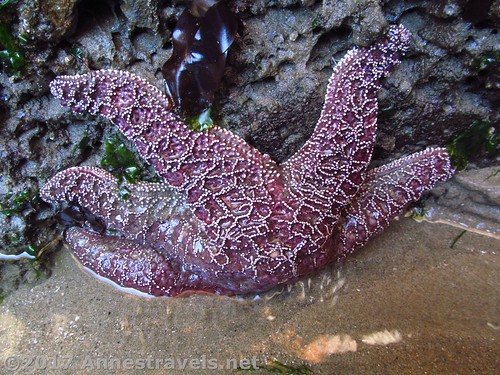
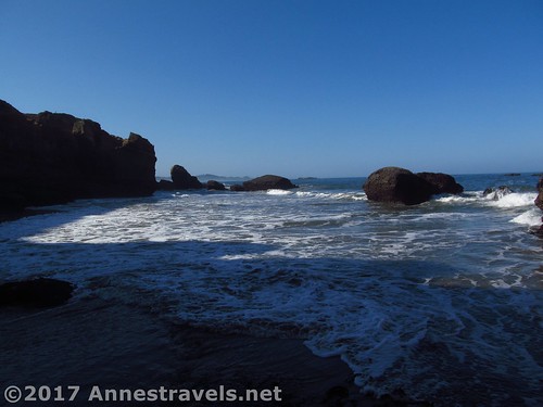
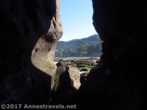
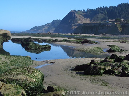
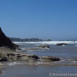
En route to the Punchbowl, enjoy the variety of tide pools and fun little rock formations created by the tides of the sea.
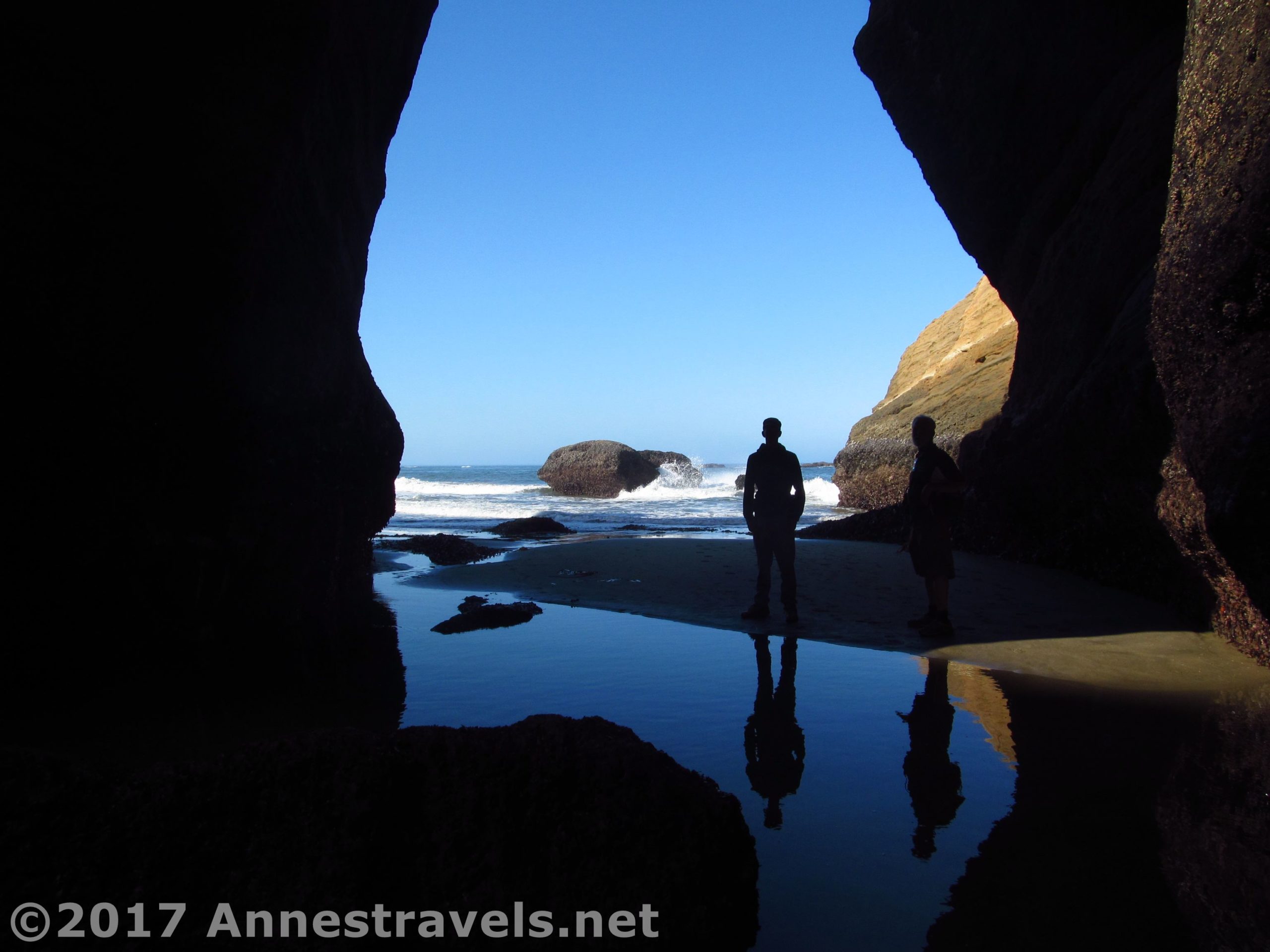
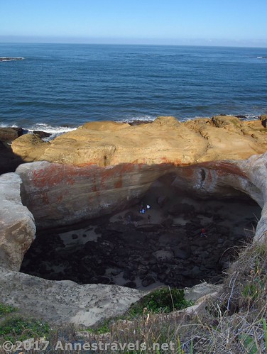
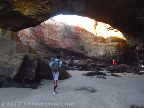
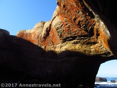
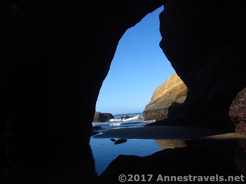
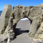
Once at the Punchbowl, you can get inside by passing through a sea arch. That’s pretty cool in itself.
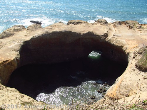
Inside the Punchbowl is like being in another world, cold, wet, with the smell of the sea. There are more tide pools and sea life, and on the sea side another sea arch lets water in and out.
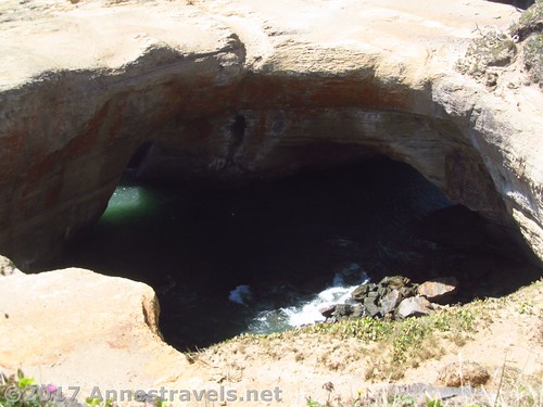
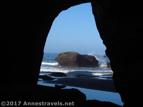
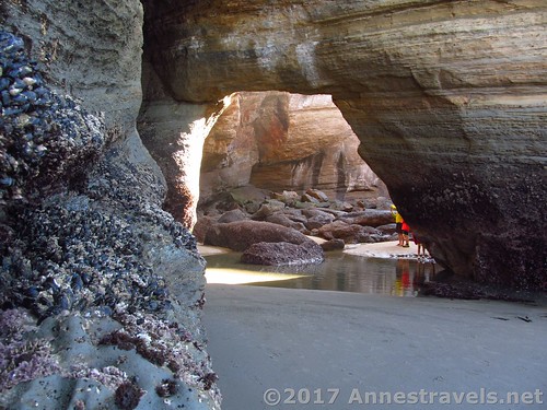
If the tide is really out, you can probably get to the sea arch on the sea side of the Punchbowl. Otherwise (or if you don’t have long legs), go back outside the Punchbowl and walk toward the ocean along the cliff until you come to a narrow opening in the rock. This is actually a kind of sea cave that goes all the way through to the other side of the rock. How cool is that?

Passing through the sea cave, come out near the sea side sea arch. Watch out for the tide, though – it started coming back in, and I had to time my running right to get between the sea arch and the sea cave. The cave itself wasn’t in any danger yet, but don’t try it when the tide is too high.

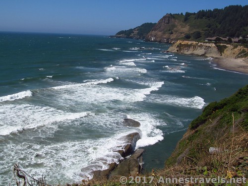
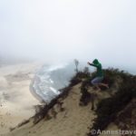
It’s also fun to come back to the Punchbowl at high tide. Instead of walking down C Avenue, keep walking down 1st Street to its end atop the headland (there is a parking area here if you don’t want to walk from the lower parking area).
Walk along the path to the edge of the cliff (there are fences). Look down into the ocean swirling within the Punchbowl, or down on the beach where we walked earlier in the morning – with the waves rolling over the rocks and tide pools!
Round Trip Trail Length: About 2 miles
Net Elevation Change: 107ft. (107ft. at the parking area to 0ft. at sea level)
Facilities: Restrooms and water at the parking area
Fees: None
Trail Notes: The lower part of this trail is impossible at high tide. Even accessing the Punchbowl may not be possible much before or after low tide, or at all during stormy weather (it was a pretty calm day when I visited in August).
Trail 
![]()
![]()
Road ![]()
Signs ![]()
![]()
Scenery
Would I go 100 miles out of my way for this? ![]()
Overall Rating: ![]()
Key GPS Coordinates for the Punchbowl
Beverly Beach / Punchbowl Parking: 44.74765N / -124.06215W (44° 44′ 51.5400″ / -124° 3′ 43.7400″) (53ft.)
Trail Beginning: 44.74756N / -124.06250W (44° 44′ 51.2160″ / -124° 3′ 45.0000″) (107ft.) (0.0; ended at 2.35)
Trailhead: 44.74913N / -124.06274W (44° 44′ 56.8680″ / -124° 3′ 45.8640″) (86ft.) (at 0.89)
Punchbowl Overlook: 44.74709N / -124.06486W (44° 44′ 49.5240″ / -124° 3′ 53.4954″) (100ft.) (at 0.66)
Punchbowl at 1.2: 44.74684N / -124.06502W (44° 44′ 48.6234″ / -124° 3′ 54.0720″) (22ft.) (at 1.2)
Punchbowl Trail Up: 44.74940N / -124.06403W (44° 44′ 57.840″ / -124° 3′ 50.5080″) (42ft.) (at 2.1)
The gpx file for the Punchbowl can be downloaded – please note that this and the GPS Coordinates are for reference only and should not be used as a sole resource when hiking this trail.
Download GPX File size: 51.2 MB” Downloaded 445 times
(Note: I do my best to ensure that all downloads, the webpage, etc. are virus-free and accurate; however, I cannot be held responsible for any damage that might result, including but not limited to loss of data, damages to hardware, harm to users, from use of files, information, etc. from this website. Thanks!)
Getting to the Punchbowl
From Newport, OR, drive north on US-101N about 7 miles. Take a slight left (an odd turn) following signs for Otter Crest and Devil’s Punch Bowl State Park. After 0.4 miles, turn left onto 1st Street for 0.3 miles. Turn right into the parking area marked for Devil’s Punchbowl.
From Tillamook, OR, drive south on US-101S about 60 miles. Turn right, following signs for Otter Rock and Devil’s Punchbowl State Park. Make a quick left onto the Otter Crest Loop. After 0.2 miles, turn right onto 1st Street for 0.3 miles. Turn right into the parking area marked for Devil’s Punchbowl.
Zoom map out to browse nearby hikes & places of interest
This Week’s Featured Product!
With a little bit of everything, this is a comprehensive guide to visiting the Oregon coast, with suggestions on the best sights to take in.

3 responses to “Exploring the Punchbowl: Above and Within”
[…] the beginning of the trail twice – the second time to do the hike, the first to try and find the Devil’s Punchbowl. From the Devil’s Punchbowl sign next to the parking area, walk down the long set of stairs to […]
[…] next day, we wandered around a bit to find the Devil’s Punchbowl. It was well worth visiting at low tide, as we could scramble over the volcanic rock and tide […]
[…] The Punchbowl, Devil’s Punchbowl State Park, Oregon. It has been said that time and tide wait for no man, and The Punchbowl is one place you wouldn’t want to be caught by the tide. At low tide, the rocky bowl with two sea-arch entrances is filled with tide pools and tourists scrambling around for a better look. At high tide, the bowl fills with several feet of water, crashing, churning, and icily cold, and even the nearby beach is under the sea. No, you definitely don’t want to be caught here. About 2 miles RT. […]