
It’s crowded, it’s dangerous, it was cloudy, and it’s about as touristy as the Oregon Coast gets. But somehow I totally enjoyed visiting Cape Kiwanda along the Tree Capes Scenic Loop off of US-101 south of Tillamook, OR. Maybe it’s because you can leave the crowds behind and explore a sandy ledge with enthralling views into the waves of the Pacific and interesting rock formations, there are fences to keep you away from the dangerous ledges and waves, the clouds didn’t diminish from the fun, and the tourists didn’t bother us. Besides, who doesn’t like a 240ft. sand dune?
Quick Stats for Cape Kiwanda
(Affiliate links are present on this page.)
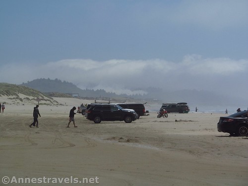
We drove down to Cape Kiwanda after spending the morning at the Tillamook Cheese Factory (totally recommended; post coming soon!) By then (it was just after noon) the parking area was nearly full, the restaurants were in full swing (including music), and the beach was filled with cars, tourists, and even a school bus. Nearby hotels hung out their signs, and more locals and visitors were pouring out onto the beach. It was nearly reminiscent of visiting Florida a few years back – though I’d probably take this over Florida.
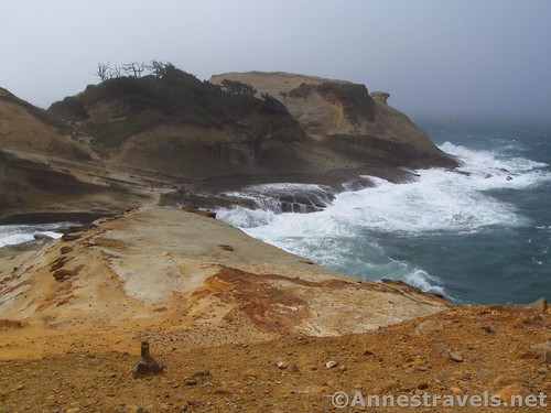
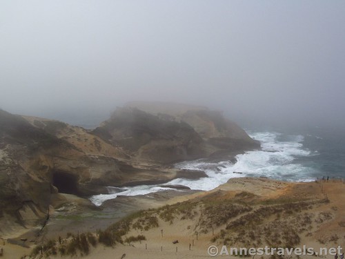
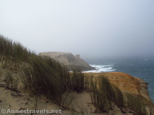
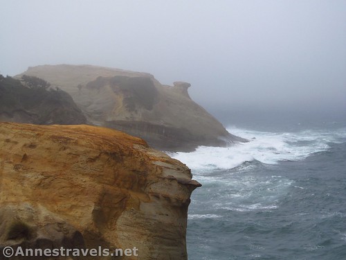
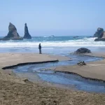
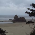
We wandered past the cars and most of the tourists, heading generally in the direction of the 240ft. sand dune to the right as soon as you access the beach. The crowds thinned a bit as we got closer to the ocean, though families were enjoying the tide pools where the headland that has the sand dune meets the ocean. There is (or was – a couple months after we visited, some crazy locals knocked it over) a fun rock formation on top of the headland, but we couldn’t see it because the mist was too thick.
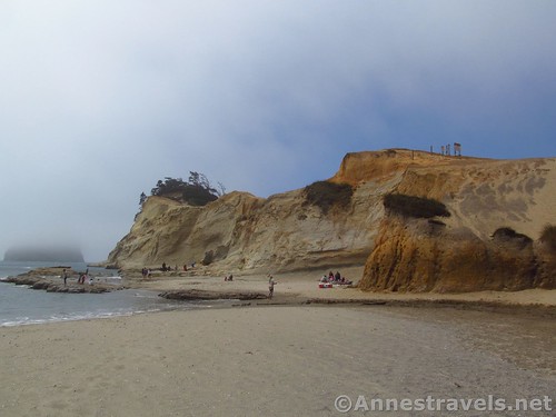
The dune isn’t like Great Sand Dunes or White Sands; it’s more like a headland with the side exposed and it’s total sand. I wondered at first if it would be as fun as a “real” sand dune, but I needn’t have worried.
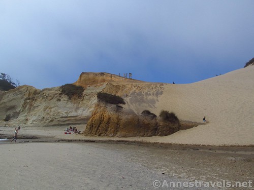
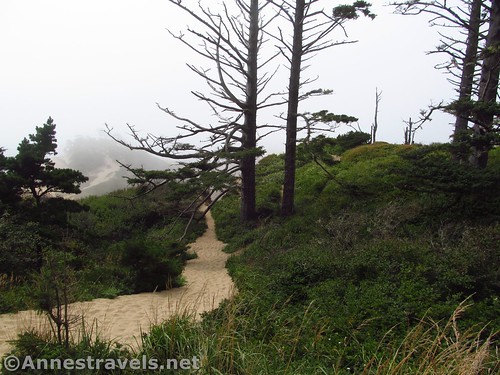
Watching people scramble laboriously up the dune, we decided to try and go up the side. So we scrambled up toward what looks like a pass between the dune and the rock headland that goes out into the water. (There are moqui-step-like depressions in the rock to help you get up to the pass.)
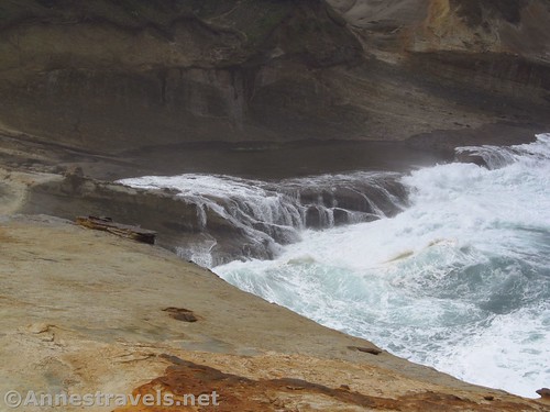
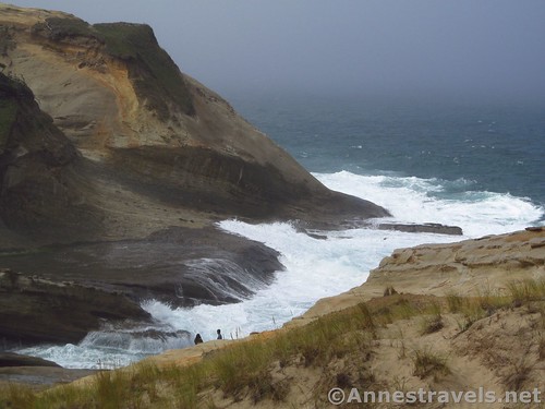
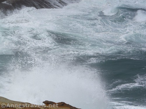
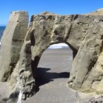
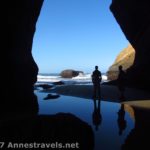
Almost immediately, we left the crowds behind. A semi-social trail leads around the dune, and before we knew it, we could walk along the fence to views of the ocean crashing in a small cove made of rock. Watching the waves was mesmerizing, and the cove was really cool with its carved sandstone.
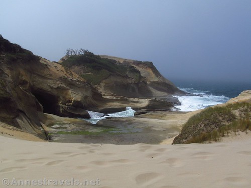
The fence continues along the side of the headland, finally ending at a point where you can look over more rock formations and north along the coastline.
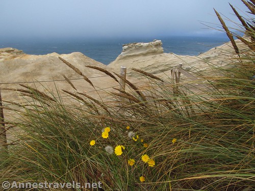
We wandered the fence for a bit. Some people came along, ducked through the fence, and went down to have a closer look at the waves. However, I’m not much on disregarding fences, and considering the fence was plastered with little closepins with the names of all the people who were washed away by getting too close, I doubly wasn’t crossing that fence. You could even see where the fence had been, but erosion had taken away the viewpoint. Triply wasn’t crossing that fence!
We enjoyed the solitude and views for a bit (the views of the headland would have been great, but the mist was so thick, we sometimes could barely see into the cove), then decided to try out the sand dune. I have group members who absolutely love sand dunes, so it seemed like a fun thing to do. Since we were already up in the pass, we followed social trails up the side of the dune. This had to be easier than slogging up the dune, itself, but it also had to be more exciting – sometimes the trail simply wasn’t anymore, having slide down the near-sheer side of the dune!
We finally made it to the top (240ft. is nothing to sneeze at!) and sat down, puffing and panting, for a rest. Most of us were carrying our shoes – it seemed better to hike barefoot than to get our hiking shoes full of sand. However, that sand was cold, and I was thankful for my jeans and jacket!
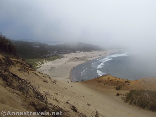
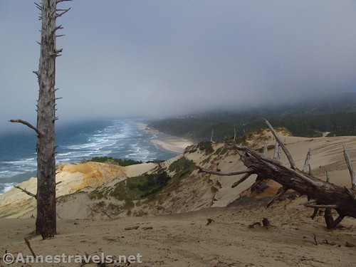
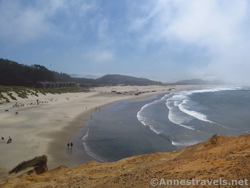
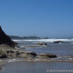
The view from the top is pretty awesome, especially to the north (the headland effectively keeps the tourists and tourist industry from spreading that direction), where the ocean ripples in to the beaches lined with forests. The few stands of dead or dying trees atop the dune make for some interesting front-drops.
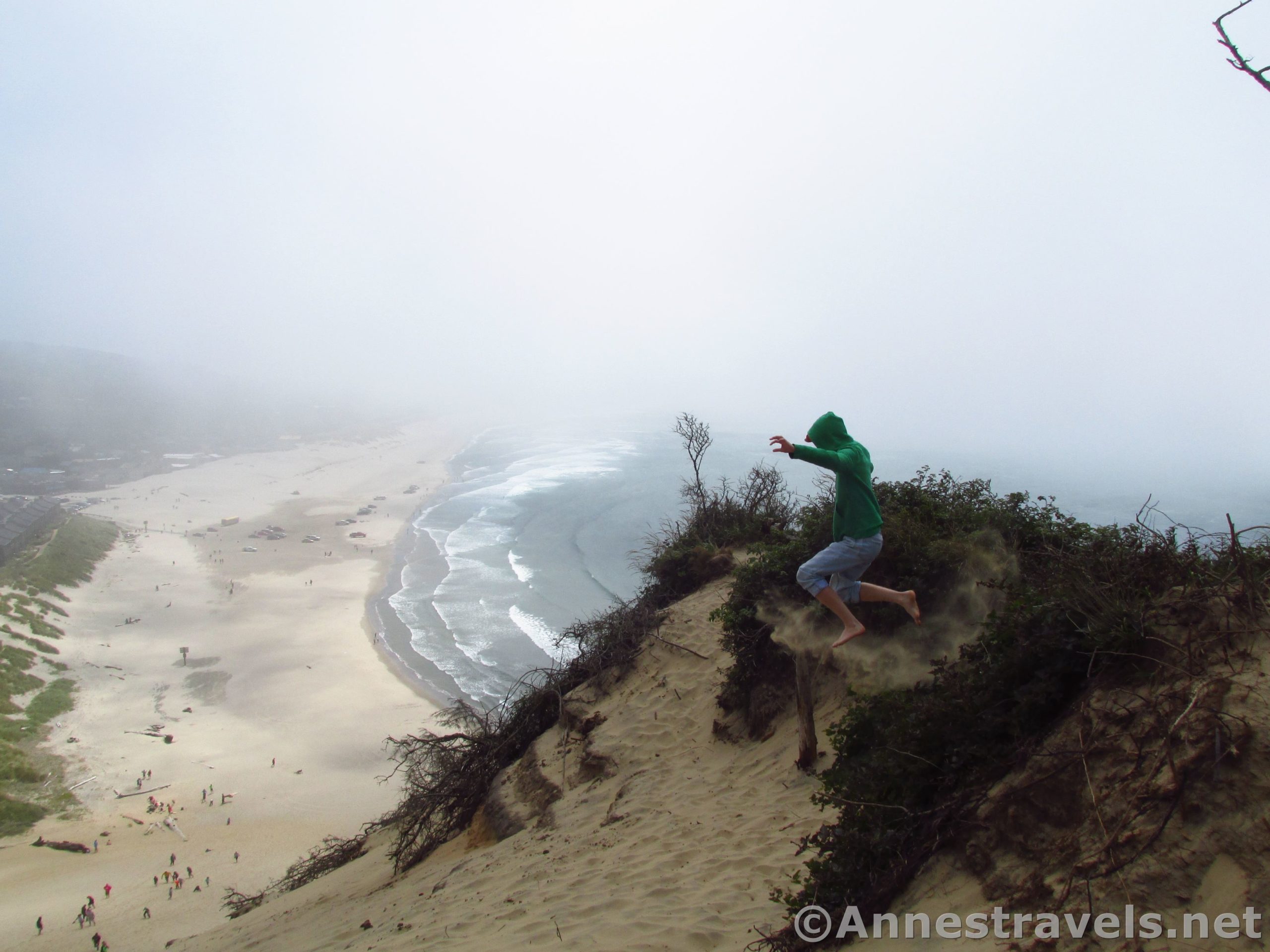
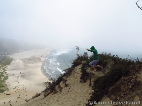
Then we had to try our hand at jumping down the dune – not all the way at first (I certainly didn’t want to have to climb all the way back up!) but just far enough that we could slog our way back up again, rest for a second, and do it all over again!
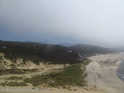
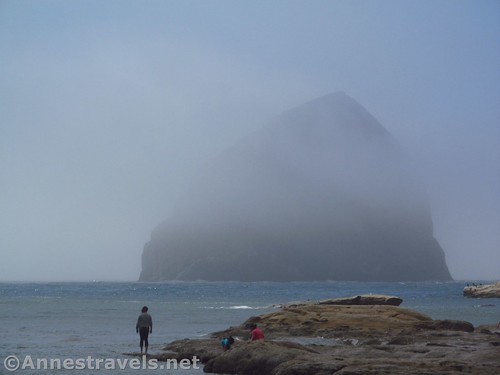
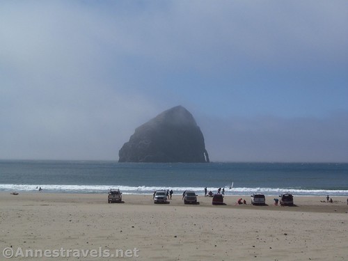
At last we tired and followed the rest of the visitors in jumping all the way down to where some of our group (who aren’t as keen on sand dunes) were waiting for us. As we walked back (skirting the tourists and the school bus that was loading its kids) the mist lifted – and there was the massive sea stack we hadn’t even seen before – Haystack Rock! (This isn’t the Haystack Rock that’s near Cannon Beach; that one is 90ft. shorter than this one. This sea stack was once named Chief Kiawanda Rock, after a local Native American leader. It would be less confusing if it had kept that name, I think.)
Bottom line: Be ready to deal with the overflow of people, but otherwise, it’s a great little couple-hour stop along the Three Capes Scenic Loop (especially if you like rock formations or jumping down sand dunes!)
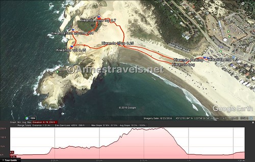
Round Trip Trail Length: I went a total of 1.3 miles. You could probably do it in less (that doesn’t include jumping down the upper part of the sand dune half a dozen times 🙂 )
Net Elevation Change: 240ft. (-5ft. at sea level to 235ft. at the top of the sand dune)
Facilities: Restaurants and lodging near the parking area.
Fees: None
Trail Notes: Be prepared for crowds if you go in the summer. Cars are allowed on the beach, so be careful (we decided we didn’t want to risk that with the van). Stay behind the fences; they’re there for your safety. The sand dune is a whole lot of fun!
Trail 
![]()
![]()
![]()
Road ![]()
Signs ![]()
![]()
![]()
![]()
Scenery ![]()
Would I go 100 miles out of my way for this? ![]()
Overall Rating: ![]()
![]()
Key GPS Coordinates for Cape Kiwanda
Cape Kiwanda Parking: 45.21560N / -123.97110W (45° 12′ 56.1600″ / -123° 58′ 15.9600″) (33ft.)
Trail Beginning: 45.21549N / -123.97094W (45° 12′ 55.7640″ / -123° 58′ 15.3834″) (33ft.) (0.0; ended 1.3)
Trail up: 45.21814N / -123.97506W (45° 13′ 5.3034″ / -123° 58′ 30.2154″) (1ft.) (0.25)
Viewpoint: 45.21884N / -123.97775W (45° 13′ 7.8240″ / -123° 58′ 39.9000″) (67ft.) (0.45)
Turn Around (end of fence): 45.21973N / -123.97718W (45° 13′ 11.0274″ / -123° 58′ 37.8480″) (79ft.) (0.54)
Top of Dune: 45.21951N / -123.97543W (45° 13′ 10.2354″ / -123° 58′ 31.5480″) (235ft.) (0.7)
The gpx file for Cape Kiwanda Sand Dune can be downloaded – please note that this and the GPS Coordinates are for reference only and should not be used as a sole resource when hiking this trail.
Download GPX File size: 51.2 MB” Downloaded 590 times
(Note: I do my best to ensure that all downloads, the webpage, etc. are virus-free and accurate; however, I cannot be held responsible for any damage that might result, including but not limited to loss of data, damages to hardware, harm to users, from use of files, information, etc. from this website. Thanks!)
Getting to Cape Kiwanda
From Tillamook, OR, head south on US-101S 11 miles. Turn right onto Sandlake Road for 4.3 miles, then turn left to stay on Sandlake Road another 6.5 miles. Continue straight onto Ferry Road / McPhillips Drive 1.4 miles. Turn right onto Hungry Harbor Road – there will be a parking area visible on right as well as a restaurant or two. Park here, or continue down to park on the beach.
Or from Newport, OR, head north on US-101N 44 miles. Turn left onto Brooten Road 2.7 miles, then turn left onto Pacific Avenue 0.2 miles. Turn right onto Cape Kiwanda Drive 1.0 miles, then turn left onto Hungry Harbor Road – there will be a parking area visible on right as well as a restaurant or two. Park here, or continue down to park on the beach.
Zoom map out to browse nearby hikes & places of interest
This Week’s Featured Product!
Find even more attractions along the Oregon coast with this mile-by-mile guide to its beaches, parks, forests, campgrounds, boat ramps, picnic areas, and trails.
One response to “Cape Kiwanda: Sand Dunes & Rock Formations”
[…] In the afternoon, we couldn’t resist seeing the churning water and jumping down the 240ft. sand dune at Cape Kiwanda. […]