

There are certain trails in certain parks that you return to, whenever you happen to be in the area. Such for us is the Cinder Cone in Lassen National Park. Most of the trail isn’t all that difficult (except for the last half mile, which might as well be straight up), and it isn’t even all that long (less than 5 miles RT; you can significantly lower the mileage by not hiking all the way around the cone). But the views are quite something, and it’s a bit of bragging rights to say that you hiked into a volcano today!
Quick Stats for the Lassen Cinder Cone Trail
(Affiliate links are present on this page.)
When we first visited in 2003 (fleeing snow in the higher reaches of Lassen Volcanic National Park), the area was owned by the national forest, but often recommend by the park rangers. By the time we visited in 2009 (again fleeing the main part of Lassen Volcanic National Park, this time because the trail to the peak was closed) the area had been traded to the park service. This removed the evidence of logging on the road, as well as instituting a day-use fee and transferring the campground to the park service.

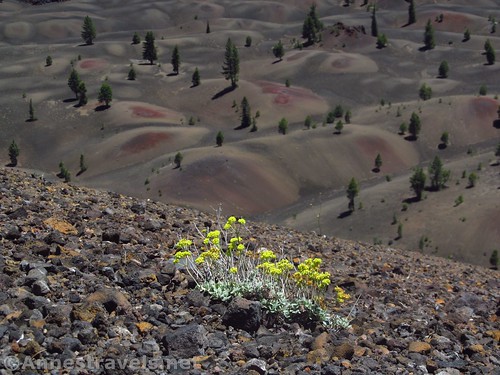
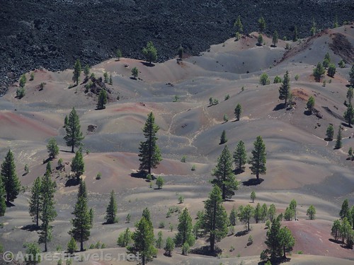
It wasn’t all bad; the cinder cone and surrounding beautifully colored cinder fields are well worth the protection offered by the park service IMHO. I think National Geographic agrees, because I don’t even read the magazine and I’ve seen the cinder fields featured at least once.
The trail to the Cinder Cone begins by the boat launch. There is very limited parking right at the trailhead; you will probably have to park a bit up the road where there is near-ample parking by the restrooms. Signs will point toward the Cinder Cone.
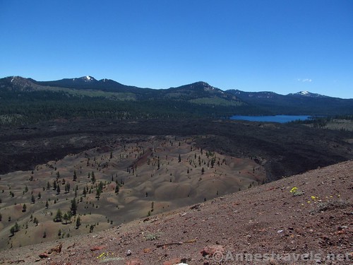
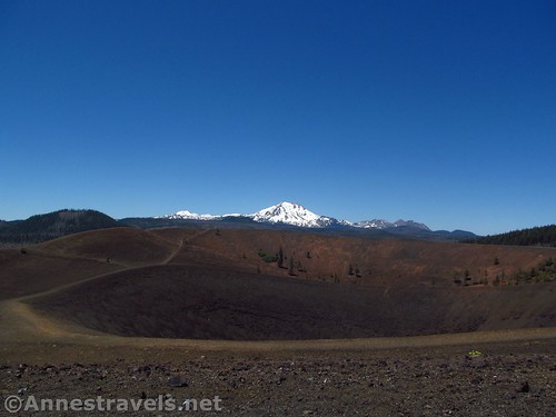
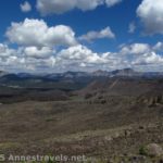
I find it odd that the Cinder Cone doesn’t have a more official name, but even on official topo maps it’s just “Cinder Cone”. The nearby cinder fields are marked as “Painted Dunes”; beyond those are the “Fantastic Lava Beds”.
The trail is mostly a gentle uphill slope, often gravely, and watch out for roots. Pick up a trail guide at the beginning of the trail; numbered signs (mostly near the beginning of the trail) suggest when to read the various sections in the booklet.
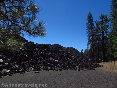
The first section of the trail is next to an old lava flow. It’s fascinating to see the huge piles of lava just to the left of the trail. A trail junction at 0.4 miles leads right toward East Prospect Peak; continue straight (left).
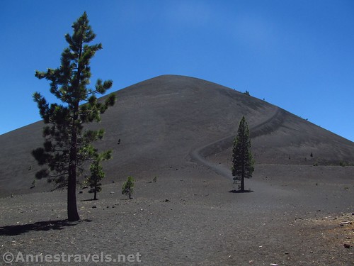
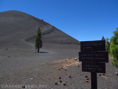
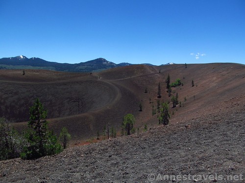
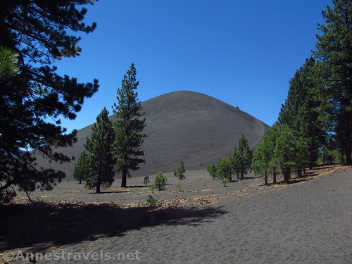
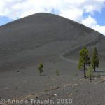
At 1.25 miles from the trailhead, the trail comes to a major junction. Most people who want to visit the cinder cone (including me!) turn left here. The trail is quite obvious up the side of the cone.
You could also go straight for a bit, then turn left and come up the back side. The views of Lassen would be better, and likely you’d get more views of the Painted Dunes. I’ve also heard that the trail is quite a bit less-easy to find. If it tells you anything, I’ve visited three times and could barely see it from the top of the cone.
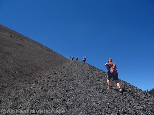
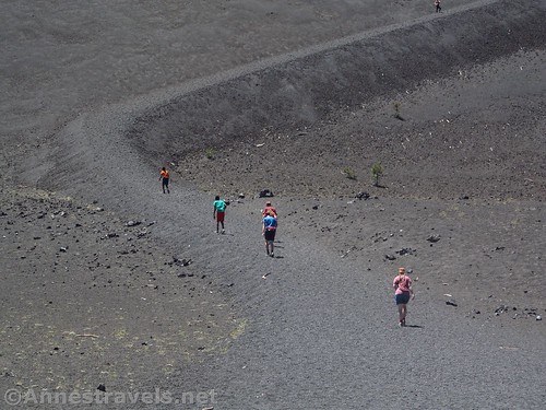
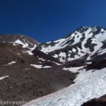
So if you turn left at the junction, it’s not long before you start climbing. The cinders make for an interesting hike – walk up a step, slide down half a step. Get your shoes full of cinders (not so much in hiking boots!) Look out and see Lassen Peak. Lots of fun, all the way around.
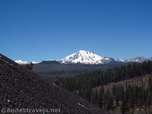
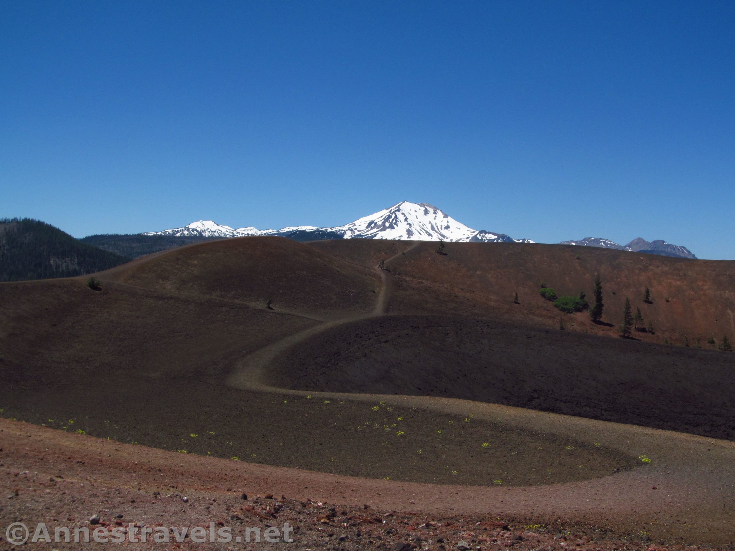
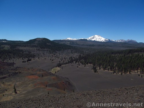
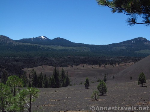
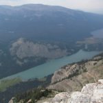
After about a half mile of slogging, come to the top of the cinder cone. The views from here are pretty striking, but I highly recommend turning left and walking along the rim. Views extend across the Cinder Cone to Lassen Peak, as well as over the Painted Dunes to Snag Lake and across the Fantastic Lava Beds to Butte Lake, not to mention a number of other volcanic hills and features. So beautiful!
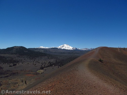
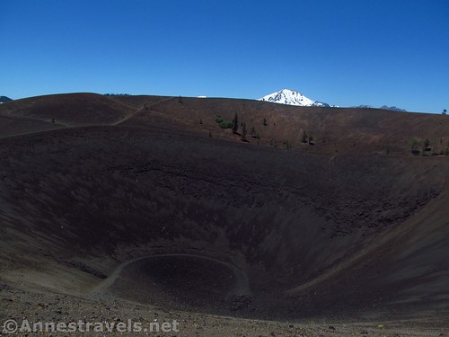
The trail around the outer rim is about 0.6 miles. You can also descend to the inner rim trail, adding almost another half mile to the hike. If you’re really feeling adventurous – and sturdy – climb down the 0.1 mile trail to the very bottom of the Cinder Cone. Just remember you’ll have to climb back up that cindery, sliding-like-ball-bearings trail!
Return the way you came, down the Cinder Cone and back to the parking area. If you’re feeling hot, you might even want to take a quick dip in Butte Lake after the hike!

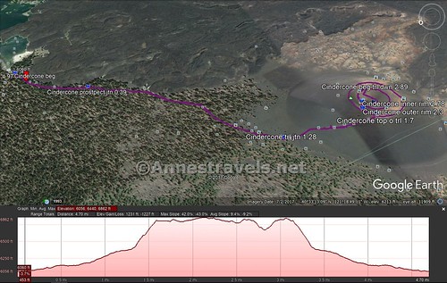
Round Trip Trail Length: 3.5-5.0 miles, depending on how much you hike in and around the Cinder Cone
Net Elevation Gain / Loss: 813ft., (6,045ft. at the trailhead to 6,858ft. on the rim)
Total Elevation Gain / Loss: Up to 1,231ft.
Facilities: Restrooms, picnic tables, small, non-motorized boat launch, campground, water in season. When we visited last July, the primitive restrooms were open, but the water was turned off, so the more traditional restrooms were locked until August, when I guess they hoped to get the water on.
Fees: $20/vehicle, valid 7 days. Lassen / Whiskeytown Annual and Interagency Passes (Annual, Senior, Access, Volunteer, Military, 4th Grader, etc.) also accepted
Trail Notes: Really, this isn’t a difficult hike until you get to the cinder cone (then it’s impossible – just kidding). However, be extremely careful in the summer months of extreme heat, and drink plenty of water on this hike!
Trail 
![]()
![]()
Road ![]()
![]()
Signs
Scenery
Would I go 100 miles out of my way for this? ![]()
Overall Rating: ![]()
Key GPS Coordinates for the Lassen Cinder Cone
Trailhead: 40.5638806°N, -121.3020972°W (40°33’49.97″N, -121°18’7.55″W /40°33.83283’N, -121°18.12583’W) (6,045ft.) (0.0; ended 4.97)
Prospect Trail Junction: 40.5601250°N, -121.3068778°W (40°33’36.45″N, -121°18’24.76″W / 40°33.60750’N, -121°18.41267’W) (6,089ft.) (0.39)
Cinder Cone Trail Junction: 40.5524472°N, -121.3190528°W (40°33’8.81″N, -121°19’8.59″W / 40°33.14683’N, -121°19.14317’W) (6,338ft.) (1.28)
Top of trail: 40.5481917°N, -121.3212972°W (40°32’53.49″N, -121°19’16.67″W / 40°32.89150’N, -121°19.27783’W) (6,804ft.) (1.7)
Outer Rim: 40.5485944°N, -121.3205333°W (40°32’54.94″N, -121°19’13.92″W / 40°32.91567’N, -121°19.23200’W) (6,864ft.) (2.3)
Inner Rim: 40.5483194°N, -121.3200500°W (40°32’53.95″N, -121°19’12.18″W / 40°32.89917’N, -121°19.20300’W) (6,845ft.) (2.78)
Trail into Crater: 40.5473056°N, -121.3190361°W (40°32’50.30″N, -121°19’8.53″W / 40°32.83833’N, -121°19.14217’W) (6,806ft.) (2.89)
Bottom of Crater: 40.5473833°N, -121.3201278°W (40°32’50.58″N, -121°19’12.46″W / 40°32.84300’N, -121°19.20767’W) (6,676ft.)
The gpx file for the Lassen Cinder Cone can be downloaded – please note that this and the GPS Coordinates are for reference only and should not be used as a sole resource when hiking this trail.
Download GPX File size: 51.2 MB Downloaded 432 times
(Note: I do my best to ensure that all downloads, the webpage, etc. are virus-free and accurate; however, I cannot be held responsible for any damage that might result, including but not limited to loss of data, damages to hardware, harm to users, from use of files, information, etc. from this website. Thanks!)
Getting to the Lassen Cinder Cone
From Manzanita Lake (main part of Lassen National Park), drive back down the road to CA-44 and turn right (east). Take CA-44E 13.5 miles, then turn right to continue on CA-44E, following sings for Susanville and Reno. After 11.0 miles, turn right onto Forest Road 32N21. A sign will indicate Butte Lake. After 6.6 miles, the road will end at the parking area; turning right will take you down to the boat launch and the trailhead.
From Susanville, take CA-36W, up into the mountains. After about 5 miles, take the exit-like turn right on CA-44W. A small sign should indicate Redding and Mt. Shasta. Drive almost 35 miles and to the left turn for Forest Road 32N21 and Butte Lake. Turn left. After 6.6 miles, the road will end at the parking area; turning right will take you down to the boat launch and the trailhead.
Zoom map out to browse nearby hikes & places of interest
This Week’s Featured Product!
Looking for even more hikes in northern California? Check out this guide, including the Cascades, Sierras, coastal regions, and more.

One response to “Climbing the Cinder Cone in Lassen”
[…] So on our way up to Redding we stopped at Lassen National Park for an afternoon of hiking the cinder cone (more shapely than I remembered […]