
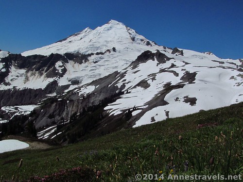
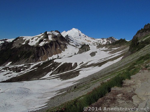
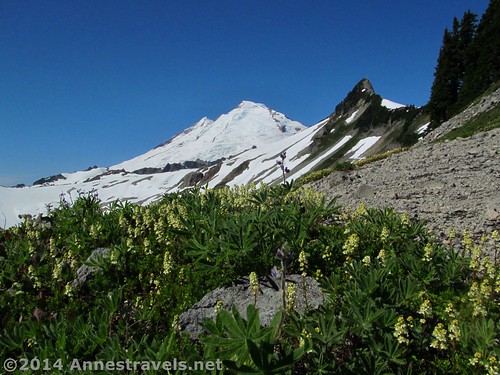
Mount Baker, as seen from the meadows near the end of the Ptarmigan Ridge Trail
“Ptarmigan Ridge or bust.” That’s what he told me one beautiful morning a few days before we planned to leave on a trip. I stared at him in disbelief. Usually a quiet, easy-going guy (particularly when it comes to which trails to hike), I wasn’t expecting anything quite this strong from anyone, let alone him. “Ok,” I said – and set out to make sure that if everything else blew up, we’d be in Washington and do that trail, 10+ miles (16+ km) RT through the snow or not.
Quick Stats
Why I hike the Ptarmigan Ridge Trail: Views of Mt. Shuksan
We’d done the Ptarmigan Ridge Trail about five years ago as a side-jaunt while doing the Chain Lakes Loop. Because of that, we hadn’t been able to go all five miles (8 km) of the trail. This time, though, we set out to do it all – and did! And all I can say is that it was a trail full of exclamation points, so I think you’ll see a lot of exclamations in this post!
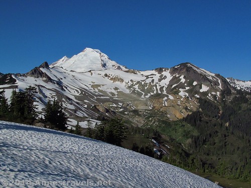
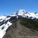
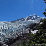
Hiking across snowfields, with Coleman Pinnacle in front of Mount Baker
Because of the strong positive feelings about the trail, I decided we should do it first-thing. This turned out to be a good decision, since we ended up spending an entire week in the Mt. Baker area (can you guess what’s going to be featured on my blog for quite a while?) and the mosquitos hadn’t hatched yet. However, this also meant that there was still a fair amount of snow on the trail. I’d say it was 60% snow covered, which really isn’t that bad considered it was only late July (often the trail is close to 100% snow covered well into August).
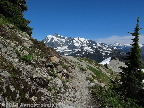
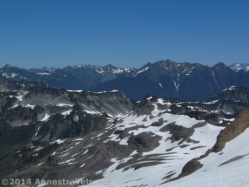
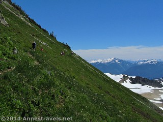
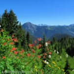
The trail often hugs the edge of the ridge – the better for the views!
We set out very early one Sunday morning, slithering down the snow-covered trailhead to the snow-free trail less than 0.5 miles (0.8 km) from the trailhead. The trail was well-packed through the snowy sections, so it wasn’t hard to find. The first 0.5 miles (0.8 km) took us on a slight uphill through the forest and then, after entering the Mount Baker Wilderness at 0.7 miles (1.1 km), to our first view of Mt. Baker. Wow! And as the trail progressed, the views got even better. Double wow!
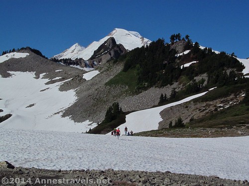
First view of Mount Baker. Wow!
At 1.1 miles (1.7 km), the Ptarmigan Ridge Trail splits left away from the Chain Lakes Trail. Here you’d leave the crowds behind, except that there weren’t any crowds this early in the morning. Washingtonites are early risers, I’d guess, but not as early as New Yorkers still living on Eastern Time (lol!) For a particularly good view of Mt. Baker, before leaving the Chain Lakes Trail continue straight along the social trails up onto a large rock with Baker directly across the valley. Amazing!
Mount Baker View from near the trail junction
Turn down the Ptarmigan Ridge Trail. “Down” is about the size of it – from the beginning, it immediately descends at an alarming rate along the side of a ridge. At last it flattens out a bit, then crosses several small streams (I’ve never had problems crossing these – usually there are stepping stones). Somewhere along this section of trail, depending on the time of year and exact conditions, the snow begins. Even in extremely dry, warm years, there are still permanent snowfields to cross. For us, the trail completely disappeared, and we had no real interest in hiking on snow, so we ended up hiking up a rib of rock, snow-hopped to another rib, and then walked the last section to the ridge on snow. If you’re not sure where to go, just keep heading for the large saddle at the end of the ridge.
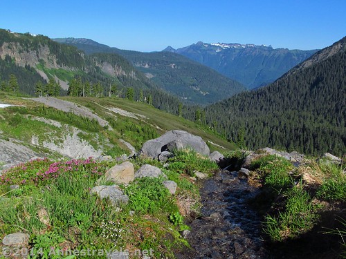
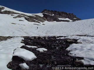
Mountain stream in this section
Not far beyond this, as the trail plunges through heather and huckleberry bushes (the former was brilliantly in bloom) you get your first views over the ridge of Shuksan. This view is better in the afternoon, with Mount Baker better in the morning, but it was still an incredible site, even with the morning haze still circling the peaks. Again we met snow on a steep embankment, but we scrambled up this and continued along the left side of the ridge (through more snow). Mount Baker was now out of view behind the ridge, but the views of Shuksan were pretty good.
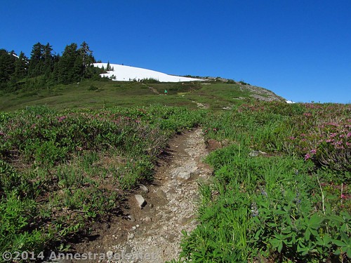
The trail atop the saddle
At mile 3.5 (5.6 km) we came to the place where we’d turned around five years ago. If you can’t do the entire trail, this is a good place to turn around. Baker is now peaking its cone over the ridge ahead and Shuksan is in its full glory across the valley. Wow!
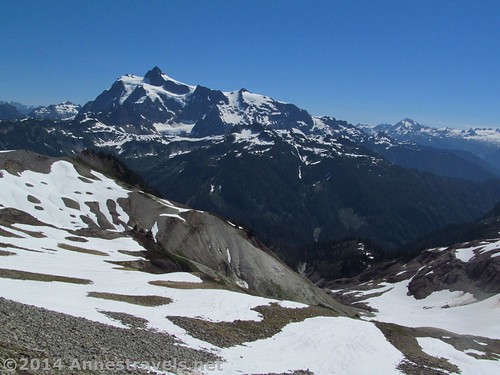
Shuksan from the 3.5 mile mark
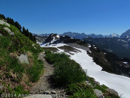
From here, the trail turns its back on Shuksan (temporarily) to wind its way along the side of the ridge. With the snow on this section melted, it was a relief to travel a bit faster over the rocky, but well-maintained, trail.
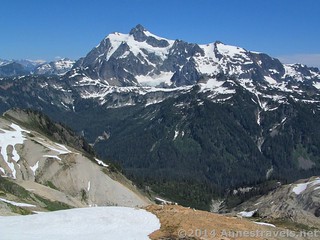
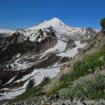
Mount Baker from the 3.5 mile point
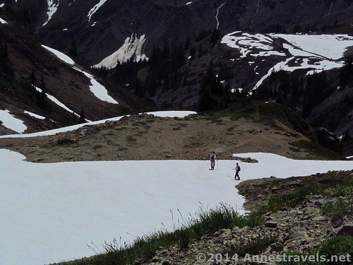
However, the snow began again all too soon. We tromped along for a bit, then completely lost the trail. Most of the way up, a visible line of footprints had headed us toward the next melted patch of trail; here, there were very few footprints and all seemed to be going in different directions. We sent out a scouting party who finally found a melted trail just past (what turned out to be) Coleman Pinnacle. Joyfully we scrambled up the snow toward the end of the ridge and the completely melted trail.
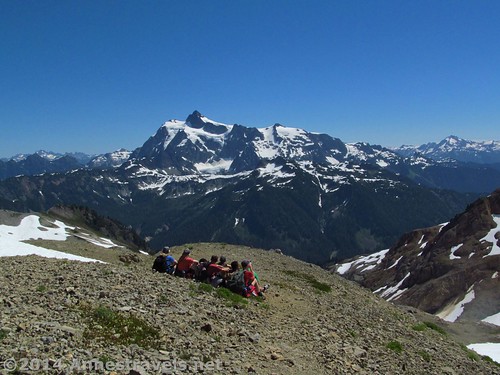
Soaking in the beauty while eating lunch
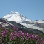
We stopped not far from here for lunch, 4.7 miles (7.5 km) from the trailhead, with Shuksan across the way and Baker looming very tall very nearby – only across one small valley. Food devoured, we followed the trail through a meadow. Although the entire trail has amazing views, this section trumped them all. Shuksan is no longer in view, but Baker is directly across the valley, so close it feels as if you could touch it (my GPS said the peak was 4 miles (6.5 km) away, as the crow flies). The Rainbow Glacier is stunning, too, and we even spotted a huge waterfall flowing into a glaciated lake ‘way up on the side of the mountain. Cool!
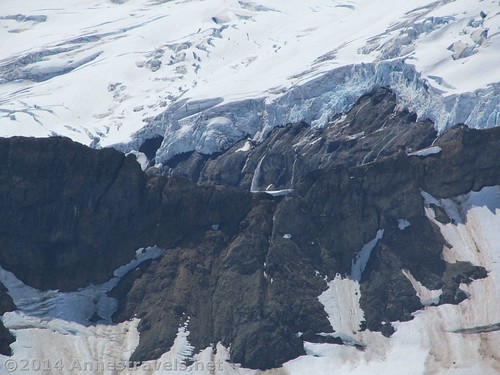
The waterfall coming out the glacier – this was about 3 miles away, so I used the furthest zoom on my camera (no fancy lenses)
We continued for another 0.4 miles (0.6 km) through a small stand of stubby pine trees to a small meadow with a saddle above it. Several of us scrambled up to the saddle to take in the view (very nice, especially of the Chain Lakes Trail). Then we knew we had to turn around, even though the trail continued for another 3 miles (5 km) (at least) to an outcrop of volcanic rock for even more views of Mount Baker. (Another hiker had done it before and was headed there again; time wasn’t going to let us do it on this visit.)
The view from the saddle above the meadow
One question still burned in my mind. Supposedly, the Ptarmigan Ridge Trail ends at Camp Keiser; I hadn’t yet seen any trace of the camp. You’d think there’d be a fire ring, at the very least, right? Then, going back, just below where we’d eaten lunch, I glanced down at a melted patch on the plateau below me – and spotted a very recognizable camp! All those lovely views hadn’t been on the Ptarmigan Ridge Trail at all; we’d been following a social trail for the last mile (2 km) or so. Well, all I can say is that this was one wonderful mistake, and one I highly recommend!
Camp Kaiser!
Going back, there were two niceties: #1, Shuksan was even grander due to the afternoon sun, and #2, a couple of the snowfields were a ton of fun to slide down!
Mount Shuksan in the afternoon – there are mountain goats near the bottom of the photo
Round Trip Trail Length: 9.5-10.5 miles (15.2 – 16.8 km) depending on snow conditions
Lowest Elevation: 5,028ft. (1,532 m)
Highest Elevation: 6,042ft. (1,841 m)
Net Elevation Gain: 1,015ft. (309 m)
Facilities: Vault toilets at the trailhead – nice enough when clean, though please close the lids for the smell factor. Signs in season. (Yes – a sign appeared one day installed in a stone wall while we were out hiking!)
Fees: $5/day (must purchase daily pass at the visitor center in Glacier – the machine is open 24 hours). Alternatively, America the Beautiful (Interagency), Senior (Golden Age), Access (Golden Access), Volunteer, Military, and Northwest Forest Service Annual Passes can be displayed. Per the park ranger, leaving your pass number in your windshield is not acceptable and the area is frequented by park rangers who ticket vehicles without passes in their windows (and I’d say frequented isn’t strong enough – there are park rangers even in the middle of the night!) Apparently pass theft isn’t a problem here (we left ours in the window for about a week and never had an issue). Discovery Passes not accepted!
Trail 
![]()
![]()
![]()
Road ![]()
Signs ![]()
Scenery
Would I go 100 miles out of my way for this?
Overall Rating: ![]()
Key GPS Coordinates
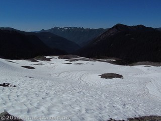
Looking back down one of the permanent snowfields that must be crossed
Ptarmigan Ridge Parking: 48.84643N / 121.69305W (5,028ft.; 1,532 m)
Trail beginning (at least when it’s snow covered): 48.84634N / 121.69344W (5,059ft.; 1,541 m)
Enter Mount Baker Wilderness: 48.84324N / 121.70584W (5,153ft.; 1,570 m)
Chain Lakes Trail / Ptarmigan Ridge Trail Junction: 48.84336N / 121.71391W (5,206ft.; 1,586 m)
Lost Trail – climbed rib of exposed scree: 48.83718N / 121.72003W (5,043ft.; 1,537 m)
After passing Coleman Pinnacle, the trail goes through lovely meadows
Regain Trail in Saddle above Snowfield: 48.83339N / 121.72132W (5,282ft.; 1,537 m)
Shuksan Baker View: 48.82450N / 121.72796W (5,640ft.; 1,719 m)
Lunch Spot – Good Views: 48.81731N / 121.74231W (5,985ft.; 1,824 m)
Meadow: 48.81996N / 121.74753W (6,042ft.; 1,841 m)
The gpx file for my hike on the Ptarmigan Ridge Trail can be downloaded – please note that this and the GPS Coordinates are for reference only and should not be used as a sole resource when hiking this trail.
Download File size: 277.5 KB Downloaded 531 times
(Note: I do my best to ensure that all downloads, the webpage, etc. are virus-free and accurate; however, I cannot be held responsible for any damage that might result, including but not limited to loss of data, damages to hardware, harm to users, from use of files, information, etc. from this website. Thanks!)
Getting to the Ptarmigan Ridge Trailhead (Artist Point)
A stream flows out of the snow – that water was cold!
From the Glacier, WA ranger station (the one place you can buy a pass if you need one, get water, and use a flush-toilet restroom – all 24 hours a day), turn right (east) onto WA-542 E (aka the Mount Baker Highway). Drive nearly 24 miles to Artist Point, a large parking lot with a spectacular view at the end of the road. The trail begins on the far end of the parking area. The road is paved the entire way, but it twists and curves through some amazing scenery – and white knuckle experiences – along the way. Also, note that the road is rarely open until July, more often August or sometimes not at all. This is one of the snowiest places on earth; in 1999 it received the world record snowfall: 95ft. (nearly 29 m)!
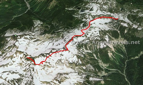
Visual map of my trek on the Ptarmigan Ridge Trail – up is north; trailhead is at upper right.
Zoom map out to browse nearby hikes & places of interest
This Week’s Featured Product!
This book includes Ptarmigan Ridge and quite a few other trails around Mt. Baker. It also details hikes in other parts of the state, including Olympic National Park and Mt. Rainier National Park.
Pingback: Anne's Travels » Canyon Ridge Trail – “Peak” into Canada
Pingback: 12 Places Worth Visiting at least 10 Miles Down a Dirt Road
Pingback: 12 Trails that Require Hands & Knees, River Crossings, and Other Adventures
Pingback: Pictures of the Lake Ann Trail to Swift Creek
Pingback: 6 Best Hikes on the Mt. Baker Highway - Anne's Travels
Pingback: Anne's Travels » The Best of Anne's Travels in 2015
Pingback: The 12 Most Popular Pictures on Anne's Travels
Pingback: 10 of the Best Trails In and Around North Cascades National Park - Anne's Travels
Pingback: 8 Epic Hikes in the Western US, Pt. 1 - Anne's Travels
Pingback: Celebrating 20 Years of Family Vacation - Anne's Travels
Pingback: An Artist Puts Himself into His Art - Anne's Travels
Pingback: Open My Eyes to See - Anne's Travels