
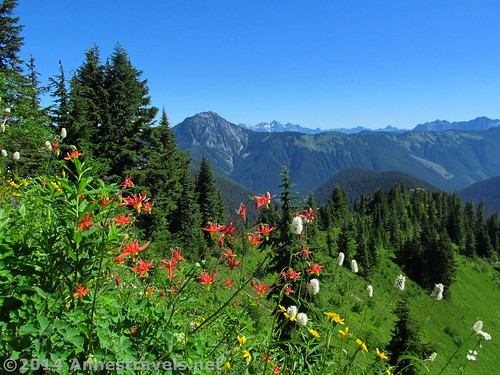
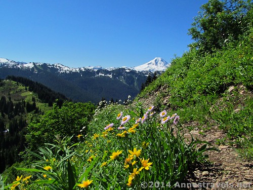
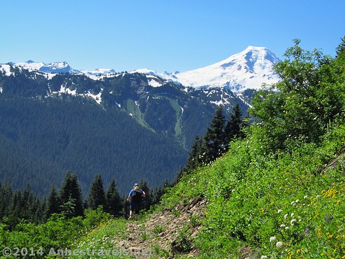
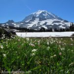
Wildflowers on Canyon Ridge, with the Canadian Cascades beyond…the boundary runs along the nearby hills
There are two really good things I can say about the Canyon Ridge Trail: 1) it wasn’t too terribly difficult, and 2) it gave a very different view than the other hikes around Mt. Baker (into the Canadian Cascades). Add to that the fact that the wildflowers were nearly in full bloom (just past peak, I’d say) and it really was a pretty hike, even if it couldn’t compete with the grandeur of the hikes that include Mt. Baker and / or Mt. Shuksan in their views. (There are actually some views of Mt. Baker, but mostly the view is of the surrounding peaks.) In all, we hiked 6.3 miles, which got us up to a very nice viewpoint just before the trail dipped back down into the trees. (Actually, in all honesty, if we hadn’t just done the Ptarmigan Ridge Trail and then done Skyline Divide (review coming soon!) the next day, we would have called this trail “spectacular”…but as it was it was just “nice” in comparison!)
Quick Stats
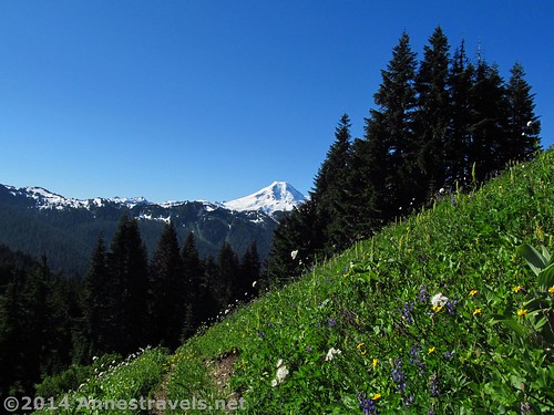
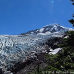
Mt. Baker is also visible from the trail
I had actually planned to hike up to Excelsior Pass via the Damfino Lakes Trail. Looking at the map in the visitor center in Glacier, it looked like a short way to a great (if famous means anything) view. But in the parking area we me a couple who had just done the Canyon Ridge Trail – “The wildflowers are in full bloom,” they told us. “The views are great, too!”
They were right…the wildflowers were out in abundance!
So, change of plans; we got up the next morning and started up the trail, turning left at the Boundary Way / Damfino Lakes trail junction, 0.6 miles from the trailhead (there is also a sign for Canyon Ridge – the junctions are all quite well-marked). Until this (and after) the trail is completely in the trees. Not quite half a mile later, we went straight when Boundary Way headed off to the right.
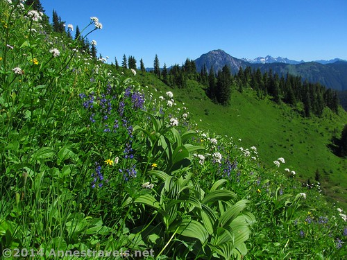
The first meadows
The trail continues through the trees for another mile, then breaks out into a short section of meadows. When the wildflowers here are in bloom, they’re lovely; there are also views of Mt. Baker’s cone in this area. In the early morning, this meadow was in shade; later in the day the sun shone on it, making it far more beautiful. All too soon the trail renters the forest.
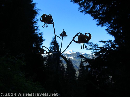
Tiger lilies in the forest
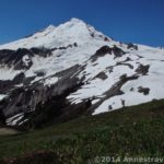
It isn’t in the forest too much longer, though. Before long it began traversing a much larger meadow on the side of the ridge. There are still some trees, but there are also very nice views of the cone of Mt. Baker.
Like this!
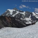
Another short stint through the trees brings you to more views of Mt. Baker, but ahead of you are now the peaks along the US / Canadian boundary – most of the mountains are in Canada, especially the snow-capped peaks.
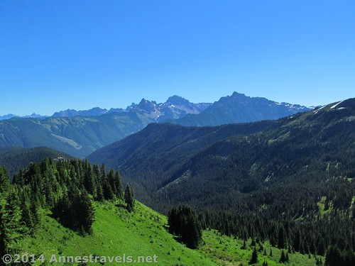
The Canadian Cascades
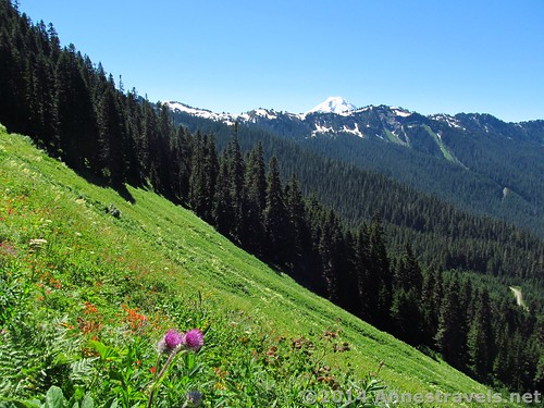
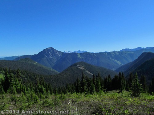
The trail continues for about a mile from the beginning of the meadow, then rounds a hill. Here in reenters the trees, then begins a downhill slope. We had no intentions of a long hike (Skyline Divide was planned for the next day!) and walking through more trees didn’t seem like a lot of fun. So we turned off the trail up toward the top of a little knoll, 3 miles from the trailhead. By moving around on the knoll, you can choose your view: nearby peaks, Mt. Baker’s Cone, or the Canadian Peaks. Since we’d seen a lot of the first two in the days before this hike, we opted for the Canadian view.
The Canadian view
After a slightly early lunch, we headed back down the trail. A total of 6.3 miles wasn’t a very long hike, but the wildflowers were pretty and it was so interesting to look across an international boarder to see the peaks on the other side!
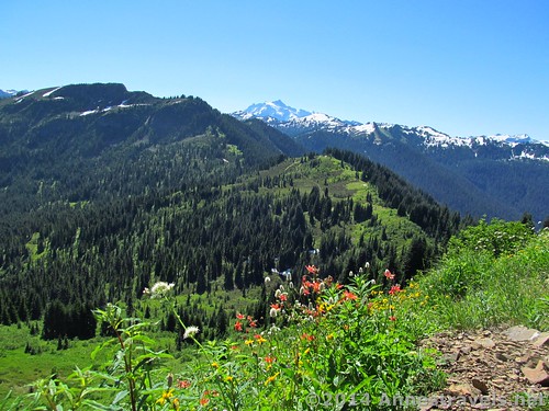
Wildflowers and Mt. Baker
Round Trip Trail Length: 6.3 miles
Starting Elevation: 4,204 ft. (parking area)
Highest Elevation: 5,350 ft. (top of knoll)
Net Elevation Gain / Loss: 1,146 ft.
Facilities: Pit toilets at the parking area. No water is available after the ranger station in Glacier, WA.
Fees: $5/day (must purchase daily pass at the visitor center in Glacier – the machine is open 24 hours). Alternatively, America the Beautiful (Interagency), Senior (Golden Age), Access (Golden Access), Volunteer, Military, and Northwest Forest Service Annual Passes can be displayed. Per the park ranger, leaving your pass number in your windshield is not acceptable and the area is frequented by park rangers who ticket vehicles without passes in their windows Apparently pass theft isn’t a problem here (we left ours in the window for about a week and never had an issue). Discovery Passes not accepted!
More views from where we ate lunch
Trail 
![]()
![]()
Road ![]()
![]()
![]()
Signs
Scenery ![]()
Would I go 100 miles out of my way for this? ![]()
Overall Rating: 
![]()
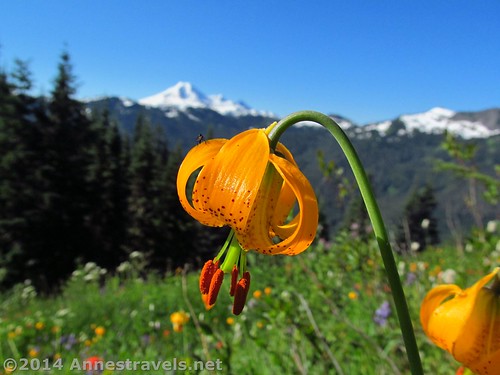
The tiger lillies were abundant on the trail
Key GPS Coordinates
Canyon Ridge Parking: 48.95896N / -121.80707W (48° 57′ 32.2554″ / -121° 48′ 25.4514″) (4,204ft.)
Canyon Ridge Trail Beginning: 48.95915N / -121.80693W (48° 57′ 32.94″ / -121° 48′ 24.9474″) (4,251ft.) (ended 6.3)
Canyon Ridge / Damfino Lakes Trail Junction: 48.95618N / -121.79615W (48° 57′ 22.248″ / -121° 47′ 46.1394″) (4,502ft.) (0.6)
Canyon Ridge / Boundary Trail Junction: 48.96027N / -121.79798W (48° 57′ 36.972″ / -121° 47′ 52.7274″) (4,739ft.) (1.0)
Beginning of meadows: 48.96246N / -121.80299W (48° 57′ 44.856″ / -121° 48′ 10.7634″) (4,865ft.) (2 miles)
Deer Trail up Knoll: 48.97618N / -121.82274W (48° 58′ 34.2474″ / -121° 49′ 21.8634″) (5,333ft.) (3.06)
Top / Edge of Knoll: 48.97573N / -121.82293W (48° 58′ 32.6274″ / -121° 49′ 22.5474″) (5,350ft.) (3.10)
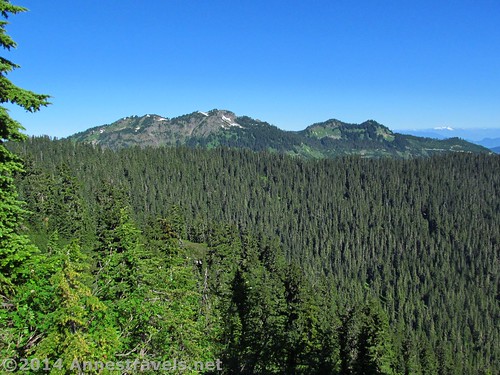
The American Cascades are also visible
The gpx file for the Canyon Ridge Trail can be downloaded – please note that this and the GPS Coordinates are for reference only and should not be used as a sole resource when hiking this trail.
Download GPX File size: 142.5 KB Downloaded 495 times
(Note: I do my best to ensure that all downloads, the webpage, etc. are virus-free and accurate; however, I cannot be held responsible for any damage that might result, including but not limited to loss of data, damages to hardware, harm to users, from use of files, information, etc. from this website. Thanks!)
Hiking back to the trailhead
Getting to the Canyon Ridge Trail
Continue past the Glacier, WA ranger station; drive almost 2 miles. Turn left on Canyon Creek Road (NF-31); stay on NF-31 for about 15 miles to its end at the Damfino Lakes Trailhead. A primitive restroom and picnic table are located in the small parking lot.
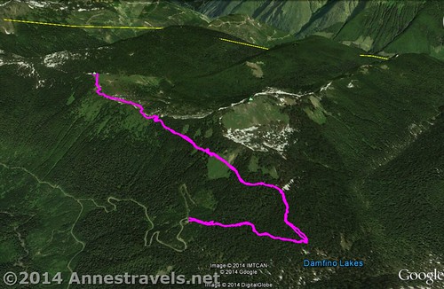
A visual map of the Canyon Ridge Trail – up is north, and the yellow line is the international boundary
Zoom map out to browse nearby hikes & places of interest
This Week’s Featured Product!
There are a ton of great hikes in this book! It focuses on the Cascades, although it covers a few other areas, as well.
More Related Posts:
 Skyline Divide: Best Views around Mt. Baker
 Stunning Views of Washington’s Famed Mt. Baker: The Ptarmigan Ridge Trail
 Ptarmigan Ridge – So Many Exclamation Points!
 Heliotrope Divide and Coleman Glacier – Fantastic Views!
 Artist Ridge Trail – So Short, So Awesome Shuksan!
 Lovely Mt. Rainier Views from Spray Park
Pingback: A Foretaste… - Anne's Travels