

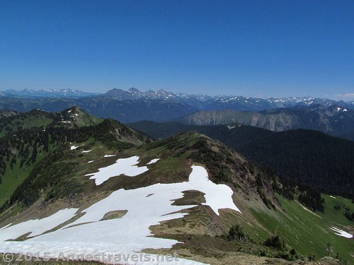
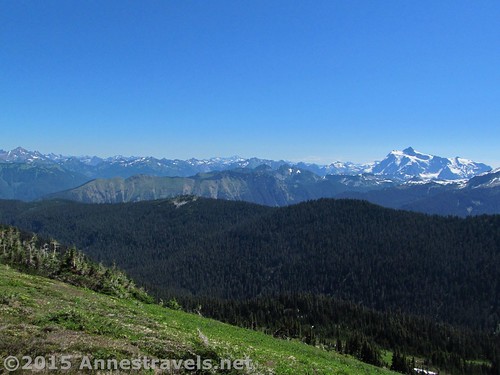
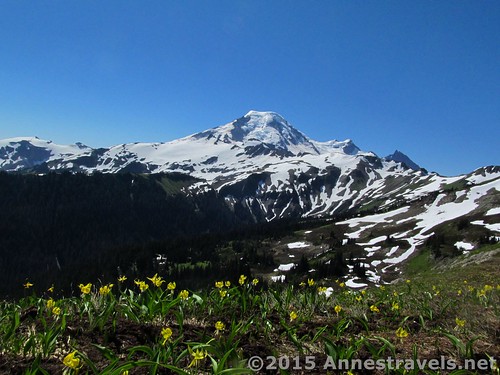
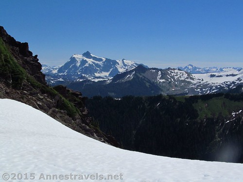
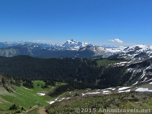
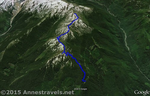
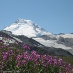
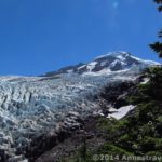
Skyline Divide! What can I say for the jaw-dropping views, the endless vistas, and the snowcapped peaks nearby and far away? Every time I thought we’d gotten to the best of the best views, we crossed another high point on the ridge and were awe-struck again by the grandeur around us. Mt. Baker is at the head of the ridge – becoming closer and grander the closer you get – and Mt. Shucksan is a couple valleys away. Meanwhile, the Canadian Cascades are beyond the end of the ridge. The trail length is variable, but we hit what I’d consider the best of the views just before mile 5. We went another half mile further for a total hike of 10.1 miles (anyone else have the problem that their GPS at the end of the hike isn’t reading double the amount it was reading when you turned around?)
Quick Stats
(Affiliate links are present on this page.)
I have to admit, I like ridge walks to begin with, so Skyline Divide was high on my list of “must do” hikes while in the Mt. Baker area. It was listed as being one of the best hikes by the WTA website, and now that I’ve done several of their “recommended” hikes, I’d have to say they list some of the best of the best. But it still didn’t prepare me for the incredible scenery along the ridge.
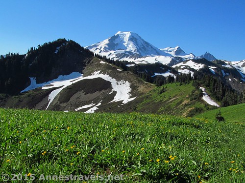
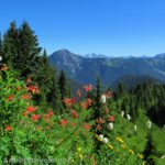
The first 2 miles are quite uninteresting – just a steep trail through a forest. Still, it’s over pretty quickly, so I can’t complain too much. At 2.0 miles, enter the Mt. Baker Wilderness Area; 0.1 miles later, crest the Skyline Ridgeline amid lovely meadows that would be filled with wildflowers in season.
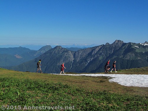
This is where the majority of the hikers turn around. But I can’t fathom that. The views are good, don’t get me wrong. In fact, they’re very good. But even turning right and walking over the next hump in the ridge has so much better views (with even better views the further you go) that it’s worth the extra miles to do, even if you don’t have much time!
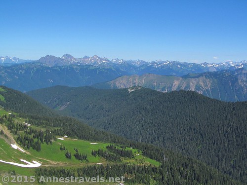
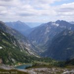
Before truly hiking along the ridge, we turned left along the deeply eroded trail for about 0.1 miles to overlook the Canadian Cascades. If you don’t have time, I wouldn’t bother with it, but I did enjoy the stillness of the meadows this early in the morning (I think it was around 7am PDT) and the views from this area.
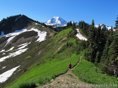
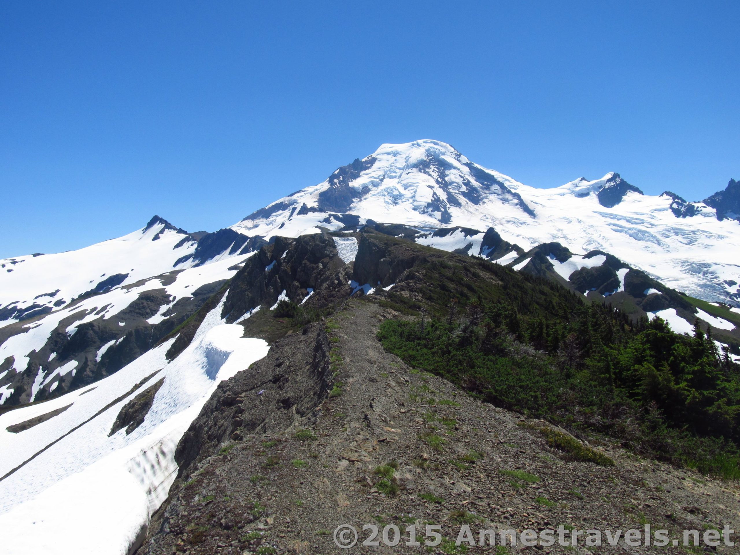
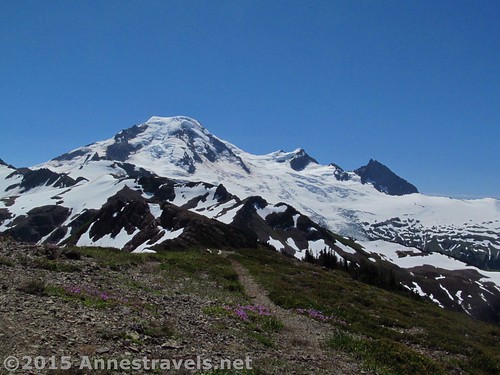
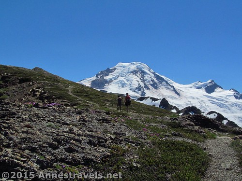
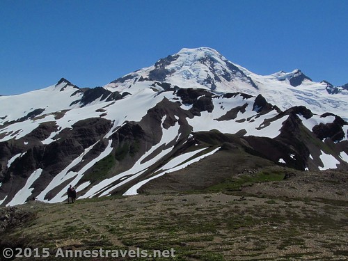
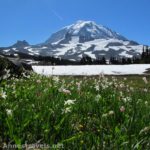
Then we turned back and started walking along the Skyline Divide Ridgeline toward Mt. Baker. I’ll mostly let the pictures speak for themselves, but I will say the further you go, the better the view.
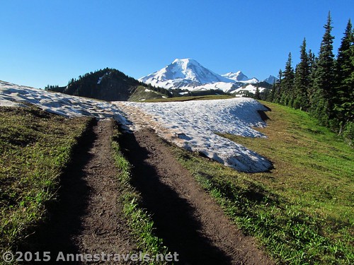
I’d say that the trail isn’t maintained beyond entering the Wilderness. However, it does go along the top of the ridgeline in more or less good shape. Trying to go over some of the humps in the ridge can be exciting, but often there is a trail around the humps if you’d rather. We also ran into some snow patches in late July, but considering what it usually looks like in July, I think we made out pretty well.
The only thing you really have to worry about is a trail split at 3.8 miles. Take the right trail, which continues along the top of the ridgeline, rather than taking the left trail, which descends into the valley.
At 4.9 miles, after an especially steep, rocky climb (not through bushes anymore), reach what looks from here to be the high point on the ridge at 6,520ft. (It actually does get higher, but this looks high as you stand on it.) I would call this the best of the best of the views. From here, the trail diminishes, and only Mt. Baker becomes grander as you climb closer and closer to it.
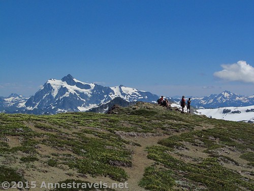
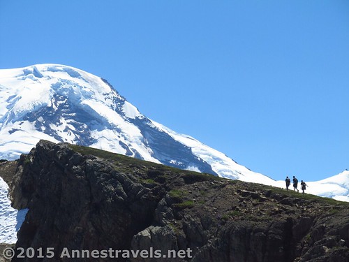
We continued another half mile to another viewpoint (about 4 miles as the crow flies from Mt. Baker’s cone) where we could see snowboarders enjoying a large snow cornice below us. Cool!
Then we knew we had to turn around. As much as some of us would have loved to continue on the trail, it was getting snowier and we’d already hiked 5.5 miles…
Overall, I can’t recommend this hike more. It definitely came out on top of my favorite vacation spots on that trip…even over the other totally spectacular hikes in the Mt. Baker area!
Round Trip Trail Length: About 10 miles
Lowest Elevation: 4,296 ft. (trailhead)
Highest Elevation: 6,525 ft. (about 5 miles from the TH)
Net Elevation Gain/Loss: 2,229 ft.
Facilities: Restroom and a couple picnic tables at the parking area.
Fees: $5/day (must purchase daily pass at the visitor center in Glacier – the machine is open 24 hours). Alternatively, America the Beautiful (Interagency), Senior (Golden Age), Access (Golden Access), Volunteer, Military, and Northwest Forest Service Annual Passes can be displayed. Per the park ranger, leaving your pass number in your windshield is not acceptable and the area is frequented by park rangers who ticket vehicles without passes in their windows. Apparently pass theft isn’t a problem here (we left ours in the window for about a week and never had an issue). Discovery Passes not accepted!
Trail 
![]()
![]()
Road ![]()
![]()
Signs ![]()
![]()
![]()
Scenery
Would I go 100 miles out of my way for this?
Overall Rating: 
![]()
Key GPS Coordinates for the Skyline Divide Trail
Parking: 48.88101N / -121.86445W (48° 52′ 51.636″ / -121° 51′ 52.02″) (4,249ft.)
Trail Beginning: 48.88046N / -121.86501W (48° 52′ 49.6554″ / -121° 51′ 54.0354″) (4,296ft.) (ended 10.1)
Begin the meadows: 48.86747N / -121.85233W (48° 52′ 2.8914″ / -121° 51′ 8.3874″) (5,547ft.) (1.6)
Enter Mount Baker Wilderness: 48.86822N / -121.85059W (48° 52′ 5.592″ / -121° 51′ 2.1234″) (5,783ft.) (2.0)
Skyline Ridgeline: 48.86776N / -121.85001W (48° 52′ 3.9354″ / -121° 51′ 0.0354″) (5,813ft.) (2.1)
Viewpoint off of main trail: 48.86922N / -121.84940W (48° 52′ 9.1914″ / -121° 50′ 57.84″) (5,839ft.) (2.2)
Back to main trail: 48.86770N / -121.85001W 48° 52′ 3.7194″ / -121° 51′ 0.0354″) (5,921ft.) (2.3)
Trail Split: 48.85324N / -121.85036W (48° 51′ 11.6634″ / -121° 51′ 1.2954″) (5,960ft.) (3.8)
High point: 48.84231N / -121.85773W (48° 50′ 32.3154″ / -121° 51′ 27.828″) (6,519ft.) (4.90)
Turn around viewpoint: 48.83769N / -121.85427W (48° 50′ 15.684″ / -121° 51′ 15.3714″) (6,525ft.) (5.5)
The gpx file for Skyline Divide can be downloaded – please note that this and the GPS Coordinates are for reference only and should not be used as a sole resource when hiking this trail.
Skyline Divide GPX Download File size: 249.7 KB Downloaded 712 times
(Note: I do my best to ensure that all downloads, the webpage, etc. are virus-free and accurate; however, I cannot be held responsible for any damage that might result, including but not limited to loss of data, damages to hardware, harm to users, from use of files, information, etc. from this website. Thanks!)
Getting to the Skyline Divide Trailhead
From the Glacier, WA ranger station, drive east on the Mt. Baker Highway (WA-542 E) for 0.7 miles. Turn right onto Glacier Creek Road / NF-39. Shortly after, take the first left onto NF-37 (NF-3) and drive 12.6 miles to the end of the road and the parking area – the parking area is near the restroom; the road continues to the trailhead. After the trailhead, the road has been blocked off (for quite some time, I’d say). The road itself is not exactly well-maintained (watch for potholes and washboard on NF-37), but it seems to be ok for low-clearance vehicles (judging by the number I saw in the parking area).
Zoom map out to browse nearby hikes & places of interest
This Week’s Featured Product!
If you’re looking for a book with more hikes in the Mt. Baker and northern Cascades area, this one is a great option. It also has hikes in Olympic, Mt. Rainier, and beyond.
More Related Posts:
 Canyon Ridge Trail – “Peak” into Canada
 Lovely Mt. Rainier Views from Spray Park
 Stunning Views of Washington’s Famed Mt. Baker: The Ptarmigan Ridge Trail
 Some of the Best Views in the Cascades from Sahale Arm
 Heliotrope Divide and Coleman Glacier – Fantastic Views!
 10 of the Best Trails In and Around North Cascades National Park
11 responses to “Skyline Divide: Best Views around Mt. Baker”
[…] (Actually, in all honesty, if we hadn’t just done the Ptarmigan Ridge Trail and then done Skyline Divide (review coming soon!) the next day, we would have called this trail […]
[…] Skyline Divide (post coming soon!). Then, there’s Skyline Divide. It has to be one of the most impressive […]
[…] WTA website directed me toward Skyline Divide on the Mt. Baker […]
[…] Skyline Divide, Mt. Baker Wilderness, Washington. […]
[…] Skyline Divide. What can I possibly say about Skyline Divide? The majesty of the view from it defies description. Alpine meadows give way to views over the Canadian Cascades in one direction and the snow-capped cone of Mount Baker in the other direction. Every mile hiked along the ridgeline is more epic. 4 to 10+ miles RT. […]
[…] Skyline Divide, Mt. Baker Wilderness, Washington […]
[…] Skyline Divide, Mt. Baker Wilderness, Washington. This is just one of those epic hikes I can’t ever get out of my head, and out-of-this-world pictures just don’t do it justice! Two steep miles through the trees, then mile upon mile of open ridgeline with totally awe-inspiring views… one of my absolute favorites around Mt. Baker! 4.2 miles minimum with up to 2,229 ft. elevation gain. […]
[…] Skyline Divide. A true favorite on my last visit, this trail promised a lot and delivered so much more. Walking for miles along the ridgeline with Mt. Baker ever present, and Mt. Shuksan close by – not to mention the lovely wildflowers and peaceful valleys not so far away – this is a one-in-a-million hike. 4.2 to 10+ miles RT. […]
[…] The 6 Best Hikes on the M.t Baker Highway – picture is from Skyline Divide […]
[…] 1. Skyline Divide, Mt. Baker Wilderness, Washington. How can you get any better than this? Canadian Cascades, Mt. Baker’s cone, wildflowers… and on a ridge hike. It’s just plain epic. […]
[…] further reaches of Skyline Divide, Mt. Baker Wilderness, […]