
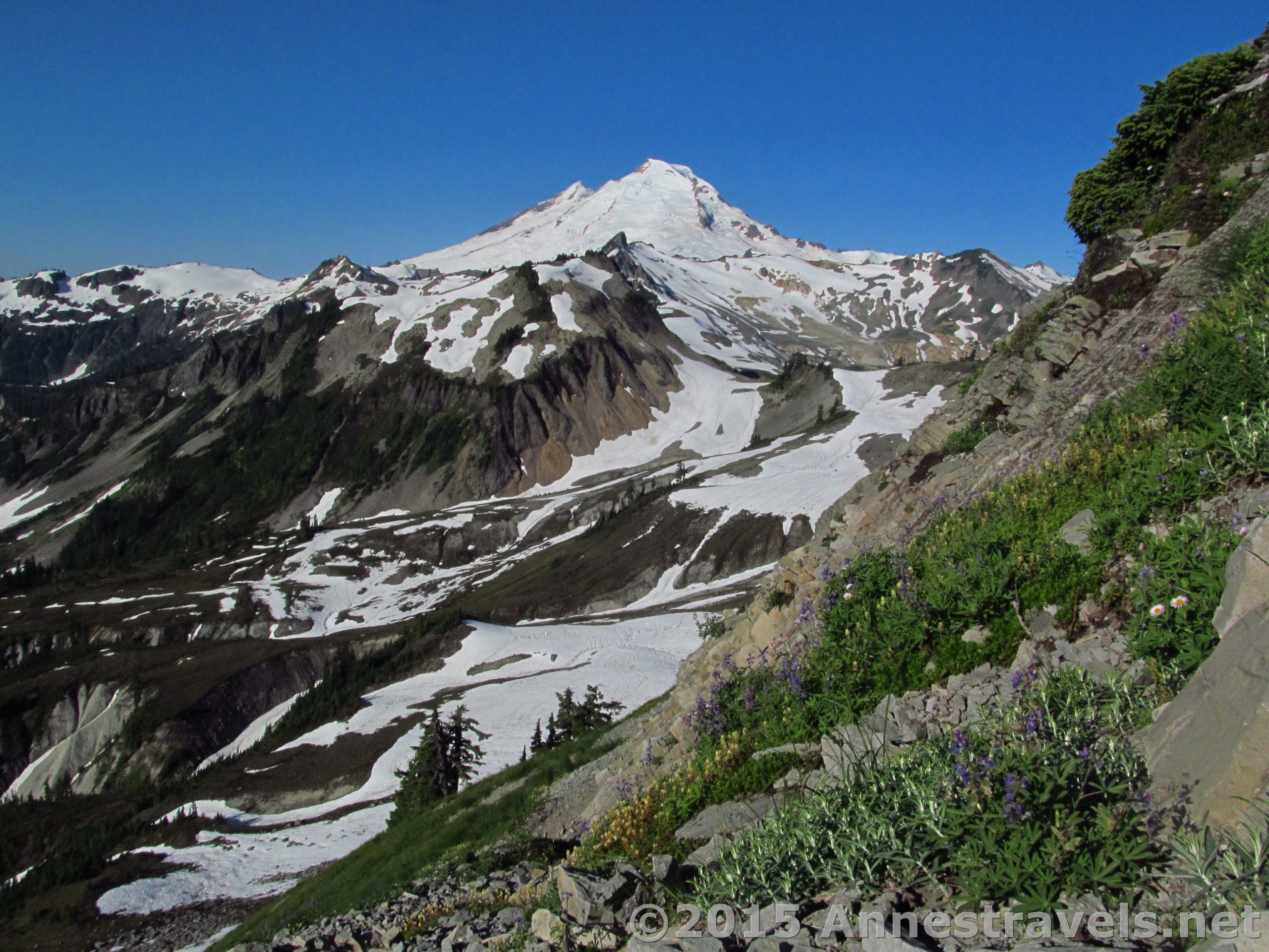
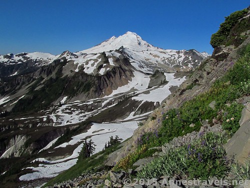
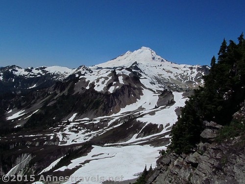
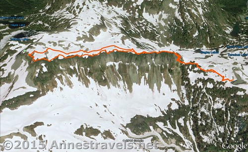
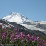
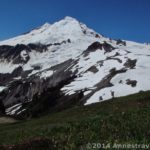
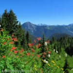
Ok, so maybe you can’t do Ptarmigan Ridge. You’d love to see those views, but you just can’t make such a long hike, especially over permanent snow fields. Well, don’t despair. There are two trails that give you similar (if not quite as intimate) views: the Artist Ridge Trail (1.5 miles RT) and the topic of this post, Table Mountain (3 miles RT). The peak is best visited in the morning, due to the position of the mountain to Mount Baker (Baker is best in the morning, and Shuksan is best in the afternoon, at least from this part of the Mount Baker Highway). When I did the trail, in late July after an unseasonably hot and dry few weeks, Table Mountain was still quite snowy on top, but that wasn’t an issue: simply take to the snow instead of trying to work your way through streams, mud, and encroaching snowfields on the real trail.
Quick Stats
(Affiliate links are present on this page.)
The trail begins near the large sign on the far right end of the parking area (if your back is to the restrooms). In season, a sign is installed here, though at the time I hiked the trail, it hadn’t been installed yet and all that was visible was a stone wall. We came back a few days later and, voila, there was an impressive sign, complete with a trail map!
Note: The map / gpx don’t show it, but when snow doesn’t cover the trail, you’ll have to walk about 0.25 miles down the Chain Lakes Trail, then turn onto the Table Mountain Trail. Since you couldn’t see where the Chain Lakes Trail was anyway, we simply followed the footprints of others and scrambled up the snowbank behind the sign to the well-maintained trail.
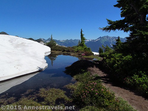
The trail immediately begins switchbacking upward. I can’t tell you much about the early part of the trail, since it was still under snow, but before long it emerged into a nicely built path. What I mean by this is that in places stone steps have been installed; in other places, stone guardrails. This is one trail that is not for those with a fear of heights!

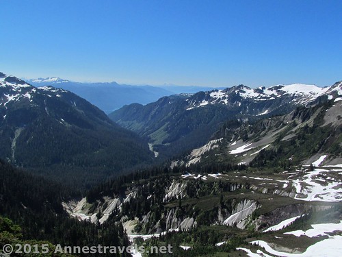
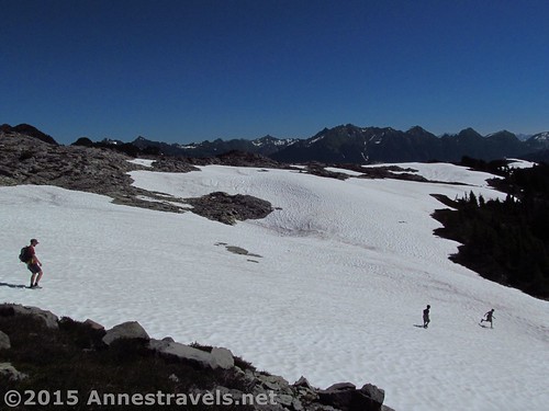
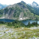
Suddenly, about 0.5 miles, the trail comes to a junction. You have reached the top of the mountain. Not knowing what else to do, we turned left (which was the correct way to go) and started following the trail. Later in the season, the trail could probably be followed, but for now there was enough snow that we took to the snowfields. In some ways this was easier than trying to find the trail, skidding up and down muddy slopes, crossing one small snowfield toe after another, and crossing the numerous small streams that run out of the snow and across the trail. On the other hand, some of the snowy areas were steep and we weren’t entirely sure we were heading the right way by simply walking toward the far end of the mountain with one false summit after another.
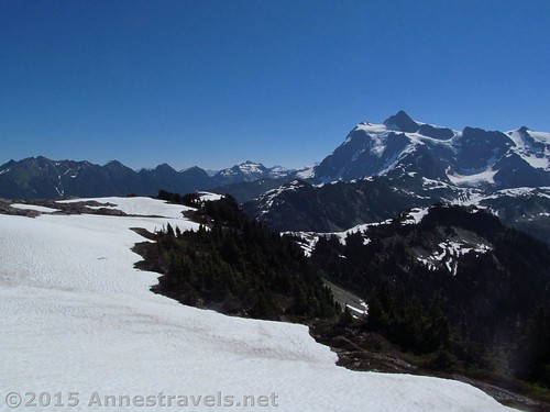
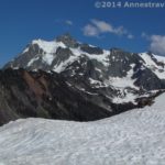
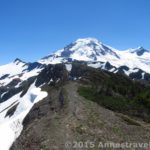
It all turned out ok, though. At the far end of the mountain (1.5 miles) was a little viewpoint of Mount Baker. The trail continued on to connect to the Chain Lakes Trail, but since we had no interest doing that we stopped at the viewpoint and enjoyed the vistas of Mount Baker.
We returned more or less via the trail on the southern side of the mountain (which is how I know the snowfield is easier). Table Mountain isn’t a long trail, but its views can be big – especially if you can’t (or have already done, or don’t want to) do the longer trails in the area!
Round Trip Trail Length: 3.0 miles
Lowest Elevation (parking lot): 5,028 ft.
Highest Elevation: 5,684 ft.
Net Elevation Gain / Loss: 626 ft.
Facilities: Vault toilets at the trailhead. Signs in season.
Fees: $5/day (must purchase daily pass at the visitor center in Glacier – the machine is open 24 hours during the summer). Alternatively, the American the Beautiful Pass, Senior Pass, Access Pass, or Northwest Forest Service Pass can be displayed. Per the park ranger, leaving your pass number in your windshield is not acceptable and the area is frequented by park rangers who ticket vehicles without passes in their windows (and I’d say frequented isn’t strong enough – there are park rangers everywhere, even in the middle of the night!) Apparently pass theft isn’t a problem here (we left ours in the window for about a week and never had an issue).
Trail 
![]()
![]()
Road ![]()
Signs ![]()
![]()
Scenery
Would I go 100 miles out of my way for this? ![]()
Overall Rating: ![]()
Key GPS Coordinates for Table Mountain
Table Mountain Parking: 48.84643N / -121.69305W (48° 50′ 47.1474″ / -121° 41′ 34.9794″) (5,028ft.)
Trail Beginning: 48.84663N / -121.69345W (48° 50′ 47.8674″ / -121° 41′ 36.4194″) (5,058ft.) (ended 2.97)
Table Mountain Top; turn Left: 48.84849N / -121.69852W (48° 50′ 54.5634″ / -121° 41′ 54.672″) (5,489ft.) (2.4 – 0.5 on google earth)
Mount Baker Wilderness Boundary: 48.84735N / -121.70898W (48° 50′ 50.4594″ / -121° 42′ 32.3274″) (5,571ft.) (1.2)
End (Nice View): 48.84738N / -121.71301W (48° 50′ 50.568″ / -121° 42′ 46.8354″) (5,684ft.) (1.47)
The gpx file for Table Mountain can be downloaded – please note that this and the GPS Coordinates are for reference only and should not be used as a sole resource when hiking this trail.
Download GPX File size: 90.1 KB Downloaded 683 times
(Note: I do my best to ensure that all downloads, the webpage, etc. are virus-free and accurate; however, I cannot be held responsible for any damage that might result, including but not limited to loss of data, damages to hardware, harm to users, from use of files, information, etc. from this website. Thanks!)

Getting to the Table Mountain Trailhead (Artist Point)
From the Glacier, WA ranger station (the one place you can buy a pass if you need one, get water, and use a flush-toilet restroom – all 24 hours a day), turn right (east) onto WA-542 E (aka the Mount Baker Highway). Drive nearly 24 miles to Artist Point, a large parking lot with a spectacular view at the end of the road. The trail begins on the far end of the parking area. The road is paved the entire way, but it twists and curves through some amazing scenery – and white knuckle experiences – along the way. Also, note that the road is rarely open until July, more often August or sometimes not at all. This is one of the snowiest places on earth; in 1999 it received the world record snowfall: 95ft. (nearly 29 m)!
Zoom map out to browse nearby hikes & places of interest
This Week’s Featured Product!
If you’re looking for a book that covers some of the best hikes in the Mt. Baker Area – as well as many hikes in the nearby Cascade Mountains – this is a great resource!
More Related Posts:
 Stunning Views of Washington’s Famed Mt. Baker: The Ptarmigan Ridge Trail
 Ptarmigan Ridge – So Many Exclamation Points!
 Artist Ridge Trail – So Short, So Awesome Shuksan!
 Canyon Ridge Trail – “Peak” into Canada
 Skyline Divide: Best Views around Mt. Baker
 Alpine Scenery to Stun You at Mt. Baker’s Twin Lakes
2 responses to “Table Mountain near Mt. Baker”
[…] Table Mountain. A short hike with an awesome view, the Table Mountain Trail switchbacks steeply upward, then rolls along the flat top of the mountain to awe-inspiring views of Mt. Baker, Mt. Shuksan, and lakes far below. 3.0 miles RT. […]
[…] Table Mountain. Ptarmigan Ridge too much for you? Well, Table Mountain isn’t the same, but it gives you a taste – just a taste – of what it would be like to hike that trail. And since the views over Mt. Baker and Mt. Shuksan are incredibly impressive, well, why not hike it? 0 miles RT. […]