

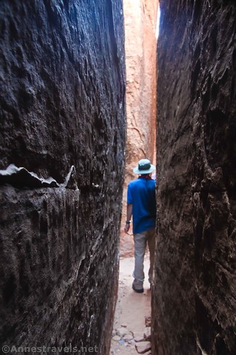
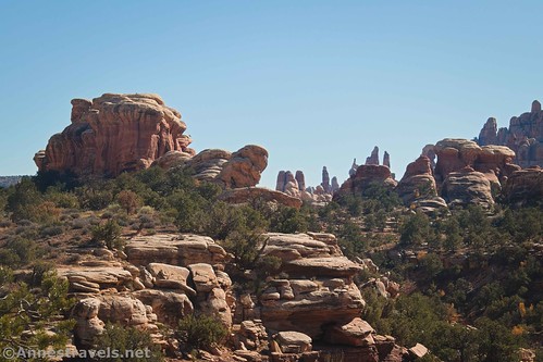
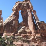
Part of why I like hiking to Chesler Park is to enjoy the spectacular rock formations. But the other reason – and I’ve actually hiked out of my way to do it – is to play around in The Joint. It’s a slot canyon, not too narrow unless you go exploring beyond the main trail. If you do go exploring – well, let’s say I’ve gotten myself into one or two slots where I couldn’t turn my head to see where I was going as I backed out!
Quick Stats
Note: Some of the links in this post are affiliate links. If you click one and purchase something, I may earn a small commission without an extra cost to you.
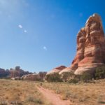
The Joint is also part of the Chesler Park Loop. So it’s fairly well-used. Most of the slot section is wide enough for all of us (including the guys) to walk through, although you might have to take off a backpack and walk sideways if you have broad shoulders.
I’ve already posted about the Elephant Canyon Trail and the Chesler Park Trail, so I’ll pick up this narrative where I left off: At the Chesler Park Viewpoint directly above where the trail drops precipitously (thankfully there are stairs!) down into The Joint.

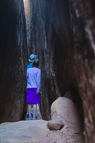
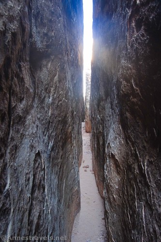
Once you’ve climbed down into the welcome cool of The Joint, the fun begins. I usually leave my pack with some of my group members who don’t like slots very much and go immediately off to explore the side slot canyons. The one directly off of The Joint is narrow (think: walking sideways) but it’s not bad.

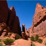
Then there are crisscrossing other slot canyons, and they can be extremely narrow. So narrow, in fact, that I’ve nearly panicked thinking I was stuck sideways and couldn’t turn my head to see where I was going as I inched my way backward into the main side-slot! (Don’t worry – this isn’t part of the trail, and you only have to explore these narrow canyons if you want to!)

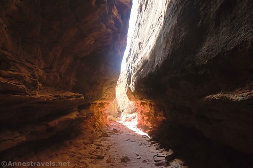
Once you’ve finished exploring to your heart’s content, continue down the main Joint (the wide one). It’s not hard walking, although there is one step down that I found to be a bit awkward.

The canyon finally opens up a bit in a sort of Subway-like formation. There are trees here, which is pretty.
At one point, the trail turns sharply right up a different canyon. While it is marked with a cairn, I almost missed it, in part because I was distracted by an especially interesting tree just beyond where the trail turns.

Turning down the correct canyon, you’ll quickly come upon dozens and dozens of cairns. I call it “Cairn Alley.” Someone had fun here!

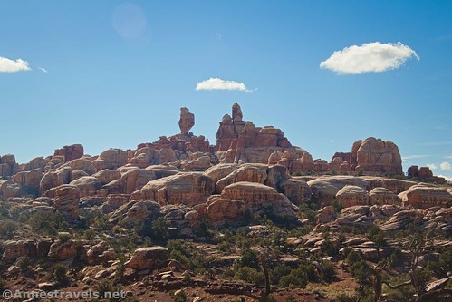
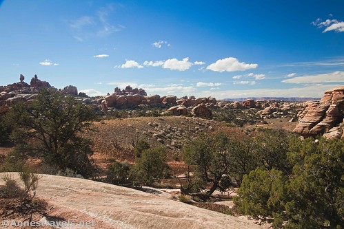
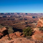
Exit Cairn Alley out into a totally different world. It’s not even the same as Chesler Park. There are more rock formations (but no more slots) and so many views to even more rocks. The trail winds between the rock formations down into a wash and then up the other side to The Joint Trailhead. Plain and simple, but there are a couple of light scramble sections and be sure to watch the cairns – the trail is winding for sure!

Along the way, enjoy views to so many rock formations! Because we were hiking in the fall, the sun was pretty far south. So the rock formations (mostly to the south) had the sun behind them despite the fact that it was close to high noon.
The Joint Trailhead is somewhat popular with jeep tours, who take guests up Elephant Hill and then over to The Joint Trailhead to use the restroom and stretch their legs with the short hike up into The Joint. There’s also a picnic table where you can eat lunch. (There used to be a sunshade over the table, but that’s disappeared sometime in the last 15 years.)
Once at The Joint Trailhead, you can retrace your steps through The Joint (a 12.3 mile out & back hike) or else you can turn right down the road to access the rest of the Chesler Park Loop (11.9 mile lollipop loop)!

Round Trip Trail Length: The Joint part of the trail is 1.3 miles point to point. The entire Chesler Park Loop is 11.9 miles per my GPS.
Elevation Gain: 121ft. up, 372ft. down (5,592ft. to 5,306ft.). I’m going to guess that my GPS got confused in such a narrow space and added a bit of elevation. Still, it did a better job than normal in a canyon, so I can’t really complain.
Facilities: Primitive restroom and picnic table at The Joint Trailhead
Fees: $30/vehicle, valid 7 days. America the Beautiful National Park & Federal Lands Passes and Southeast Utah Parks Pass are also accepted.

Trail Notes: If you’re worried about being claustrophobic, it’s not too bad. Two of my group members hate tight spaces and both made it through ok. It helps to know that there are wider spaces coming. While there could possibly be a flash flood in these slots, it’s pretty unlikely unless it’s raining. Be wary of rocks protruding from the floor of The Joint – you can step over them, but they can trip you up if you’re not watching!

Trail 
![]()
![]()
Road ![]()
Signs ![]()
Scenery
Would I go 100 miles out of my way for this?
Overall Rating: ![]()

GPS Coordinates for The Joint Trail
Viewpoint junction (begin down into The Joint): 38.104551,-109.857597 (38°06.27306′, -109°51.45582′ / 38°06’16.3836″, -109°51’27.3492″) (5,566ft.) (5.03)
Cross wash: 38.103062,-109.864827 (38°06.18372′, -109°51.88962′ / 38°06’11.0232″, -109°51’53.3772″) (5,319ft.) (6.20)
Joints TH: 38.103584,-109.866379 (38°06.21504′, -109°51.98274′ / 38°06’12.9024″, -109°51’58.9644″) (5,316ft.) (6.30)
The gpx file for The Joint Trail can be downloaded – please note that this and the GPS Coordinates are for reference only and should not be used as a sole resource when hiking this trail. Also note that the file is backward from the description here and also longer – it begins at The Joint Trailhead and travels to the junction of the Chesler Park Trail near the Chesler Park-Druid Arch Crossover.
Download GPX File size: 45.3 KB Downloaded 432 times
The gpx file for my entire trek around Chesler Park can also be downloaded.
Download GPX File size: 216.2 KB Downloaded 578 times
Getting to the Elephant Hill Trailhead
From US-191, turn onto Utah Hwy 211. This turn is 40 miles south of Moab and 14 miles north of Monticello; it is very well-marked, but easy to miss after driving a very long way from Moab through some bland if starkly beautiful scenery. From US 191, it’s about 34 miles to the visitor center and entrance station – but you’ll have plenty to look at along the way, including a very pretty canyon, rock formations, and Newspaper Rock. Pay your entrance fee (or flash your park pass) and then continue driving along the main road. After 2.8 miles, turn left towards Squaw Flat Campground. Keep right 0.2 miles later, when the left fork enters the campground. Bear right again a very short time later. (If you come to the end of the road within the next mile, you’ll know you went the wrong way). From here, the road is not exactly paved, although it is still in good condition and should be accessible by lower clearance, 2WD vehicles (I’ve done it in a Toyota Camry). Check at the visitor center for updated road information. About 3 miles from where you didn’t go to the Squaw Flat Campground, you will come to the parking area. The road continues, but it’s only for serious 4×4 vehicles (no ATVs allowed) with a permit. I watched a few jeeps trying to ascend the hill the road climbs right next to the parking area, and it’s nothing I’d want to try!
From the Elephant Hill Trailhead, you’ll need to hike the Elephant Hill Trail and the Chesler Park Trail to The Joint Trail.


This Week’s Featured Product!
This book has detailed descriptions of hiking trails in Canyonlands and Arches National Parks. Users love the detail, the accurate descriptions, and the variety of trails to choose from.

One response to “The Joint Trail”
[…] with great views of the spires. About mile 5, the trail drops into a sort of wash to a sign. The Joint Trail is to the right – over the edge of the cliff and down into The Joint (steps help you down into […]