There are a few hikes in Utah that I return to again and again. The Queen’s Garden Trail in Bryce, a few hikes in Arches (like Devils Garden and Delicate Arch), Neon Canyon, Canyon Rims, and Corona Arch are all well worth repeating for their scenic beauty. Also on this list is Chesler Park – I’ve now done it three times, and I’d happily go hike it again. It’s one of those trails that’s so spectacular that you just need to hike it a few times to take in even half of the rock formations, mountain views, cliffs, canyons, spires, desert meadows, and more!
Quick Stats
Note: Some of the links in this post are affiliate links. If you click one and purchase something, I may earn a small commission without an extra cost to you.

Unlike the last time I wrote about Chesler Park, I won’t be chronicling the entire hike in one epically long post. Instead, I’d like to do it over several posts, since each one is scenic enough to deserve its own trip report – besides, you’ll get more pictures that way! I’ll be detailing the Elephant Canyon Trail in this post, and in the upcoming weeks, I’ll post about the Chesler Park Trail to the Chesler Park Overlook, The Joint Trail, and the loop that takes you back around the west side of Chesler Park. Overall, I clocked 11.9 miles that day – but you don’t have to go the entire distance to get views worth seeing, as you’ll see in this post!
The Elephant Canyon Trail begins at Elephant Hill. The road to get there is dirt and has some tight curves, but it’s doable even for low-clearance vehicles, at least in dry conditions. Parking at the trailhead is limited, so arrive early to assure yourself a parking place. The road beyond the parking area is for serious 4×4 vehicles only, and you need a permit to drive beyond the parking area and up the hill. (You don’t need a permit if you’re hiking it – which is not the topic of today’s post, but I thought I’d throw that out there. You do need a permit to ride a horse or a bicycle up the road. Read more about the permits here.)

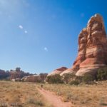
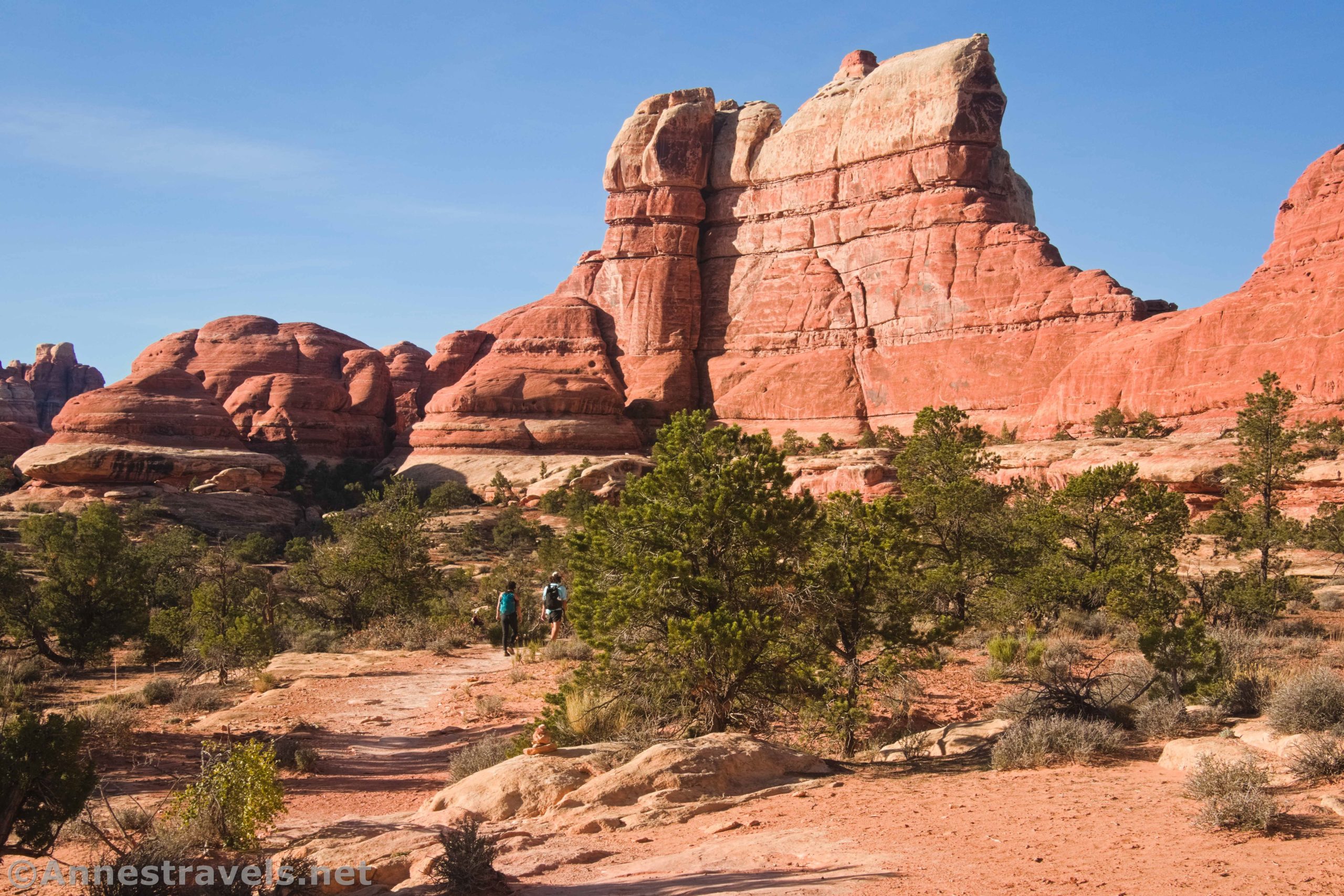
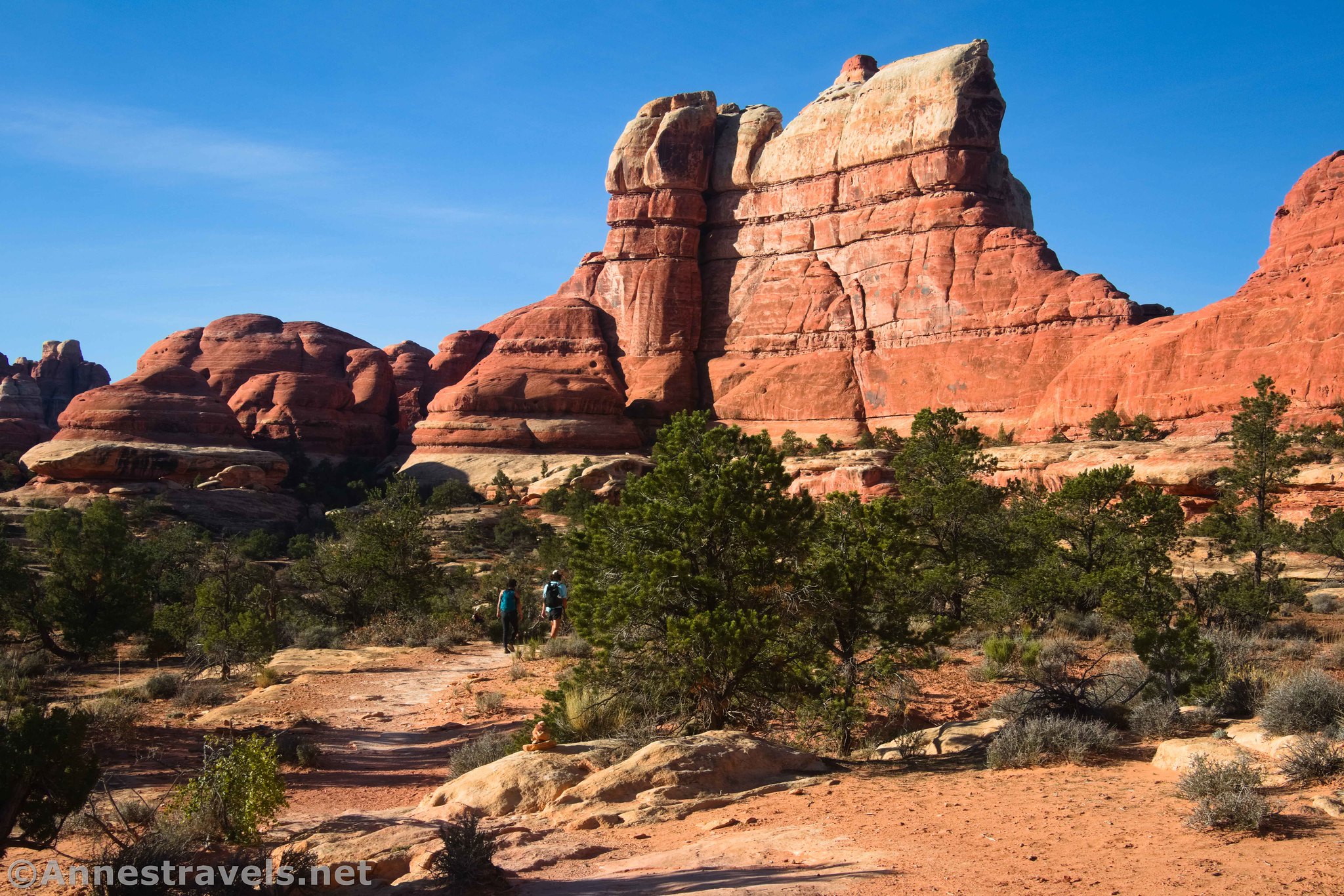
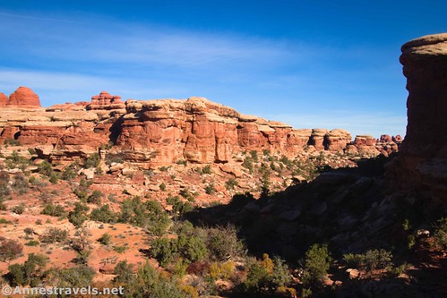
The trail from Elephant Hill begins by climbing a rock slope. It’s challenging, but only enough to turn back those who are just checking out the trail anyway. Once at the top of the rock, the path wiggles its way through some spires and out onto a wide “shelf” of rock.
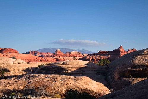
This is a spectacular portion of the trail, with huge rock spires and cliffs on the right (west) and views out to the La Sal Mountains and plenty of scenery in between on the left (north and east).
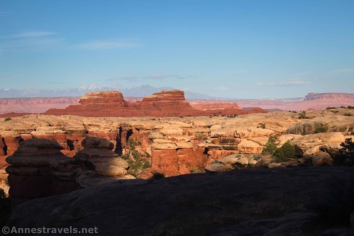
Funnily enough, you’re actually walking along and toward Elephant Hill. It’s the high point in the spires and cliffs on the right.

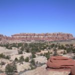
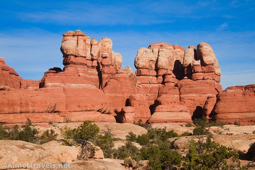
Eventually, the trail passes between the spires to the south and onto another similar rock shelf – only this time, you can see the Needles to the south. Wow!

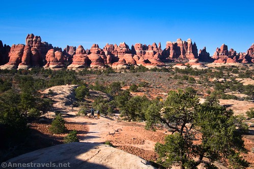
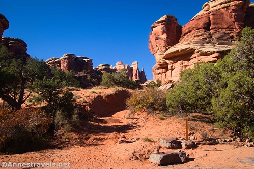
At 1 mile from the trailhead, the trail ducks down a dark, narrow passage between the spires. Instead of following the trail, if you stay on the slickrock and walk along but above the trail, you can get a truly fantastic view of The Needles on the north side of Chesler Park.
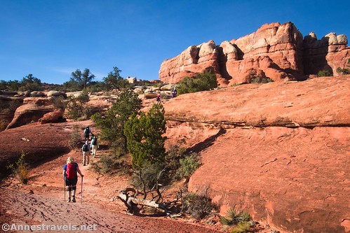
When you’ve enjoyed the view for a minute or thirty, go back to where you can safely follow the trail through the fisher and down onto a lower plain of scrubby brush and slickrock. Be sure to keep your eyes to the right (west) for views of more spires and cliffs.
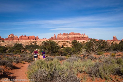
About 0.4 miles beyond the view, you’ll come to your first trail junction. This is the crossover from the Big Spring Canyon Trail and Squaw Campground (the only campground on an accessible road in The Needles District). If you happen to be staying in the campground, I highly recommend walking in from the campground if you can – it is about a mile longer (each way), but you won’t have to worry about parking at Elephant Hill. Continue straight (not left), following the sign for Chesler Park and Druid Arch.

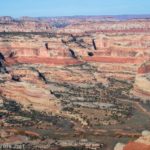
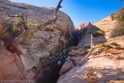
The trail continues to be scenic as it drops into Elephant Canyon. The trail works its way down a narrow fissure (but not a slot canyon, per se) through the rocks to emerge deep in the canyon.
At mile 2.0, the trail drops suddenly through the brush into the wash of Elephant Canyon. This is the official end of the Elephant Canyon Trail – which only takes you to the canyon. By going straight across, you can access Chesler Park (my destination for the day), The Joint (also my intended destination), and Devils Pocket. Turning right will take you down Elephant Canyon to a backcountry campsite (permit required). I’ve heard there is a major dryfall a short distance beyond the campground, but I don’t know if this is true or only hearsay. Going left, the trail works its way up Elephant Canyon to Druid Arch.
As a side note, I’ve done the Druid Arch Trail, and I prefer to do it via Chesler Park, then take the crossover from the Joint Trail down to the Druid Arch Trail. It’s a bit longer than taking the trail here, but you skip a lot of slogging through the sand in Elephant Canyon.
And that’s the Elephant Canyon Trail! Another 0.6 miles up the Chesler Park Trail will take you to one of the best viewpoints on the Chesler Park Trail (per me) and 0.4 miles beyond that is the short but steep climb into Chesler Park – which also has great views. I’ll be talking more about getting to Chesler Park in an upcoming blog post!
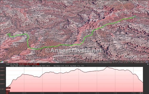
Round Trip Trail Length: 4.1 miles out & back to Elephant Canyon
Elevation Gain: 794ft. (5,138ft. to 5,394ft.)
Facilities: Primitive restroom and possibly a picnic table or two at the trailhead
Fees: $30/vehicle, valid 7 days. America the Beautiful National Park & Federal Lands Passes and Southeast Utah Parks Pass are also accepted

Trail Notes: Parking is limited at the trailhead. I recommend getting there before 9am to secure your parking place. While there are a few tight spots on the trail, it shouldn’t be an issue for most people (even one member of my group who hates tight spaces didn’t have a qualm). Be sure to follow the cairns across the slickrock so you don’t get lost. Also, at the time of this publication, the Druid Arch Trail is closed due to a broken ladder – I expect it will be fixed, but you might want to check before trying the trail.

Trail 
![]()
![]()
Road ![]()
Signs
Scenery
Would I go 100 miles out of my way for this?
Overall Rating: 

GPS Coordinates for the Elephant Canyon Trail
TH: 38.141565,-109.827322 (38°08.49390′, -109°49.63932′ / 38°08’29.6340″, -109°49’38.3592″) (5,118ft.) (0.0)
Viewpoint: 38.129014,-109.829633 (38°07.74084′, -109°49.77798′ / 38°07’44.4504″, -109°49’46.6788″) (5,380ft.) (1.06)
Squaw Canyon Junction: 38.125238,-109.832692 (38°07.51428′, -109°49.96152′ / 38°07’30.8568″, -109°49’57.6912″) (5,383ft.) (1.41)
Durid Arch Trail Junction (Elephant Canyon): 38.123523,-109.839955 (38°07.41138′, -109°50.39730′ / 38°07’24.6828″, -109°50’23.8380″) (5,212ft.) (2.04)

The gpx file for Elephant Canyon can be downloaded – please note that this and the GPS Coordinates are for reference only and should not be used as a sole resource when hiking this trail.
Download GPX File size: 51.4 KB Downloaded 408 times
The gpx file for my entire trek around Chesler Park can also be downloaded.
Download GPX File size: 216.2 KB Downloaded 520 times

Getting to the Elephant Hill Trailhead
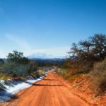
From US-191, turn onto Utah Hwy 211. This turn is 40 miles south of Moab and 14 miles north of Monticello; it is very well-marked, but easy to miss after driving a very long way from Moab through some bland if pretty scenery. From US 191, it’s about 34 miles to the visitor center and entrance station – but you’ll have plenty to look at along the way, including a very pretty canyon, rock formations, and Newspaper Rock. Pay your entrance fee (or flash your park pass) and then continue driving along the main road and, after 2.8 miles, turn left towards Squaw Flat Campground. Keep right 0.2 miles later, when the left fork enters the campground. Bear right again a very short time later. (If you come to the end of the road within the next mile, you’ll know you went the wrong way). From here, the road is not exactly paved, although it is still in good condition and should be accessible by lower clearance, 2WD vehicles (I’ve done it in a Toyota Camry). Check at the visitor center for updated road information. About 3 miles from where you didn’t go to the Squaw Flat Campground, you will come to the parking area. The road continues, but it’s only for serious 4×4 vehicles (no ATVs allowed). I watched a few jeeps trying to ascend the hill the road climbs right next to the parking area, and it’s nothing I’d want to try!
This Week’s Featured Product!
Enjoy a wide variety of hikes in this guidebook to Canyonlands and Arches National Parks! With over 40 trails, maps, trail descriptions, and more, it covers most of the hikes that can be reached with a regular vehicle in the parks.