
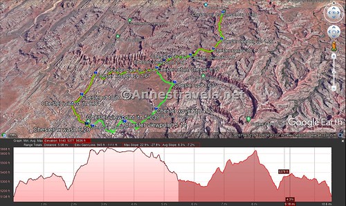
After you’ve enjoyed the spectacular views near Elephant Canyon, wandered among the spires of Chesler Park, and explored the further reaches of The Joint, it seems the Chesler Park Loop wouldn’t have much more to offer. However, at The Joint Trailhead, you still have another 2.6 miles of hiking to get back to the end of the loop (and then another 3 miles back to the trailhead). The good news is that while you’ve seen fantastic scenery already, there’s still more to come. It’s the underdog section of the Chesler Park Loop – so beautiful, and yet usually forgotten.
Quick Stats
Note: Some of the links in this post are affiliate links. If you click one and purchase something, I may earn a small commission without an extra cost to you.

To get to the Joint Trailhead, you’ll need to hike the Elephant Canyon Trail to the wash that is Elephant Canyon, then take the Chesler Park Trail up to Chesler Park. Walk along the east side of Chesler Park to the Joint Trail; take the Joint Trail down through the Joint and then to the Joint Trailhead on the Joint Road. This is the point where this guide begins.
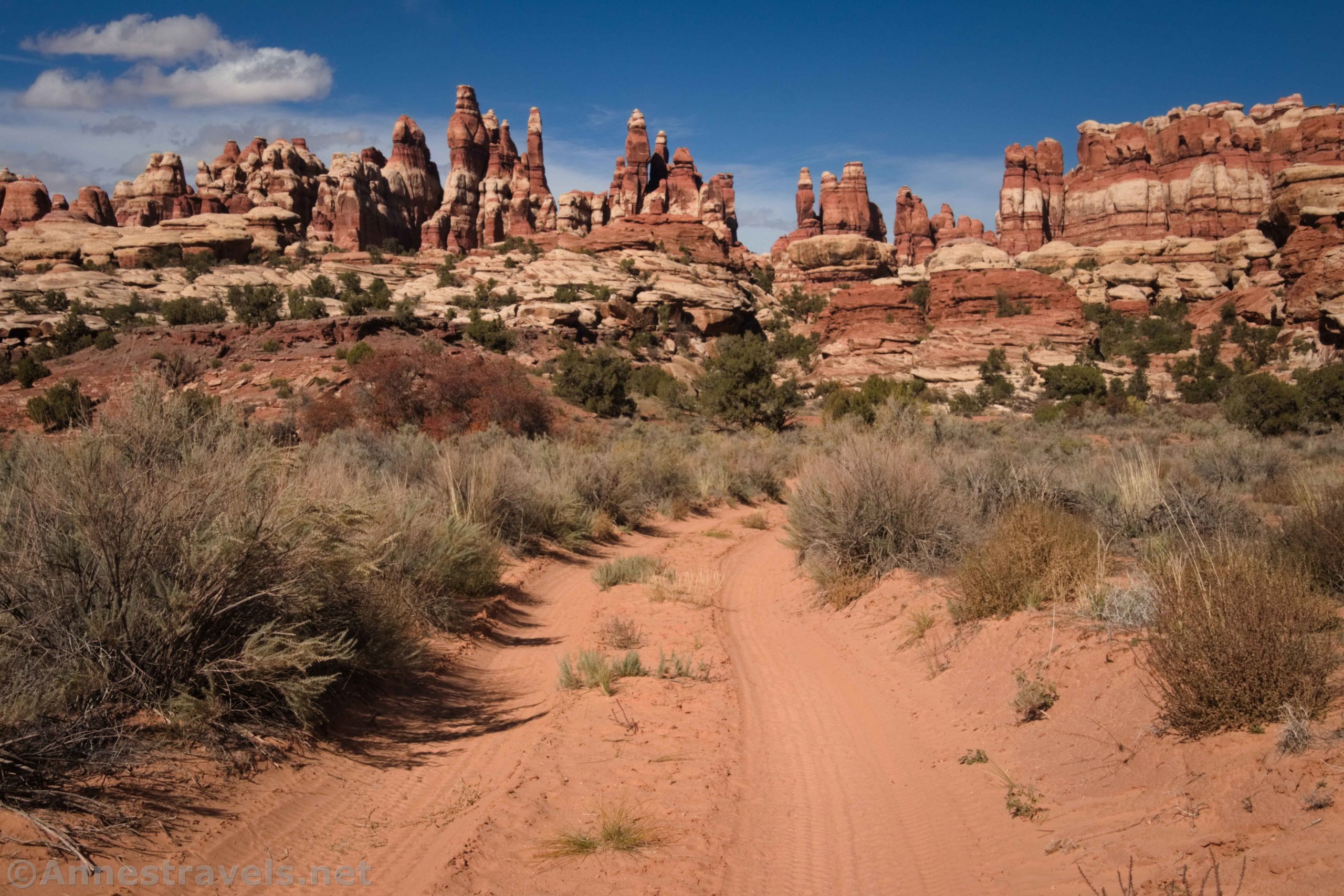
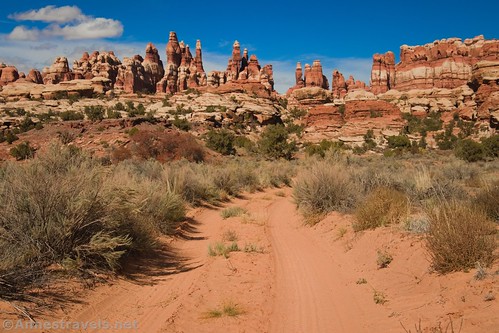
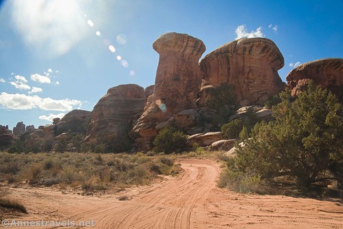
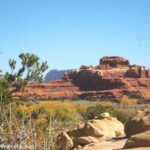
From the Joint Trailhead on the Joint Road, you’ll need to begin walking down the road. (The Joint Trailhead is a dead end, so there’s only one way to walk.) Usually, I’m not fond of walking roads, but this one is at least quite scenic and hasn’t seen much vehicle traffic either time I’ve hiked it.
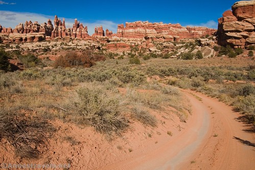
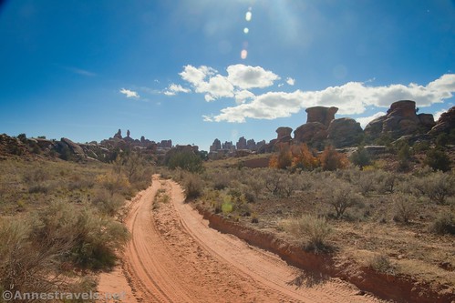
Walking the Joint Road is hot and dry. Usually, you’ll hit this section at the warmest part of the day, so it’s no wonder most people only remember it as a sandy slog (it’s actually not that bad): long, boring, and unremarkable. The reality is that it’s only 0.8 miles and the rock formations and views are impressive. After all, you get those fantastic leading lines of the road with the Needles scenery!
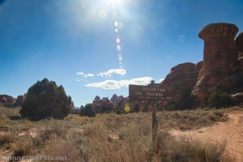
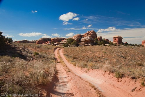
After walking 0.3 miles, you’ll come to a road junction. A sign (looking in the other direction) points left to the Chesler Park Trailhead and right to Beef Basin 10 miles. This is a “back door” so to speak to Canyonlands National Park via the Cottonwood Road (note that you’ll still need permits to enter Canyonlands in a vehicle even if you come in via the Cottonwood Road). The Bobby’s Hole section is nearly as difficult as Elephant Hill, so I hear. You want to turn right (if your back is to the sign) and continue straight on the Joint Road.

About 0.25 miles later, you’ll come to an obvious but unassuming sign on the right (north) side of the road that reads, “Chesler Park Trail.” It also says that Chesler Park is in 1.7 miles, Elephant Hill TH is in 4.6 miles, and a sign below says that no bicycles are allowed. Turn right onto this trail.

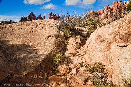
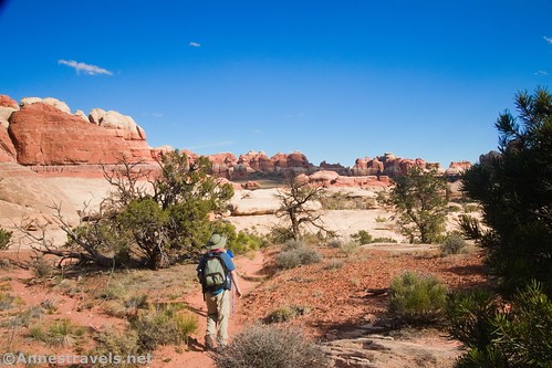
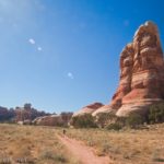
The Chesler Park Trail on the western side of the park is much wilder and more remote than the east side. The route is marked with cairns – keep a lookout for them, because while the trail isn’t that easy to lose, it’s also not always obvious. The path follows trails, washes, canyons, and scrambles up rocks at times (scrambles are little more than Class 2).
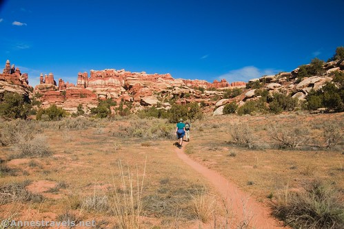
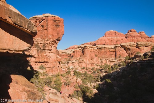
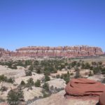
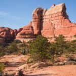
Be sure to look back as you hike – the views to the rock formations in the far southern part of Canyonlands (or possibly outside the park) are excellent.

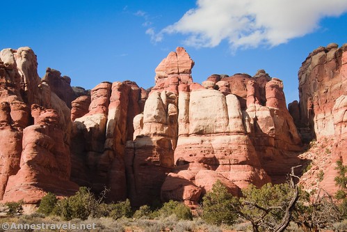
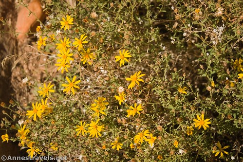
Scenery along this section of trail varies from Needles-style formations to a variety of desert flora to other rock formations. It’s a jumble of a transition area, which adds to the wild feeling of the trail.
Half a mile from the road, the Chesler Park Trail (west) meets the trail from Devils Kitchen (Devils Pocket Trail). Turn right to continue toward Chesler Park and the Joint Trail.

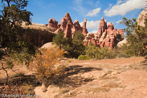
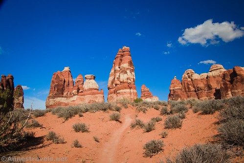
Views almost immediately begin to improve (as though what you were just walking through wasn’t beautiful!) You can see into Chesler Park, especially the spires along the northern side of the Park. The trail is also easier to follow after the junction, though you should still keep an eye out for cairns.
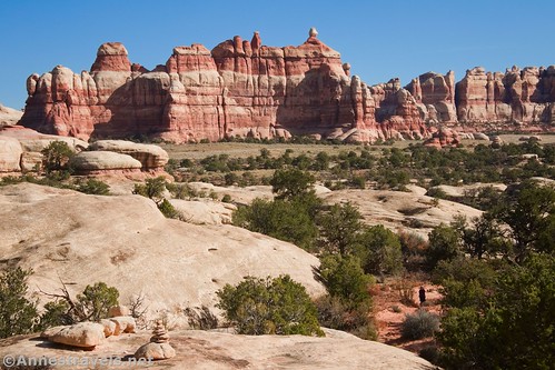
Cross washes, sandy flats, and rocks and finally wander along the base of the rock formations along the north side of Chesler Park. It’s easy to feel dwarfed here!
About 1.8 miles after leaving the Joint Road, you’ll arrive back at the Chesler Park Trail that traverses the eastern side of Chesler Park. From here, you want to turn left toward the Elephant Hill Trailhead. Almost immediately, you’ll descend the Class 3 scramble down out of Chesler Park.

My GPS tracked the route back to the trailhead as 3.1 miles on the way out and almost 3.0 miles on the way back. The great news is that 1) it’s probably a cooler time of day now, and 2) the late afternoon views along the Chesler Park and Elephant Canyon Trails are spectacular!

Round Trip Trail Length: My GPS tracked the entire loop at 11.9 miles. This section of the trail (Joint Trailhead around the west side of Chesler Park and back to the Elephant Canyon Trailhead) is 5.5 miles one way.
Elevation Gain: 2,155ft. total (5,138ft. to 5,668ft.) (this section: 945ft. up, 1,111ft. down)
Facilities: Picnic table and primitive restroom at the Joint Trailhead
Fees: $30/vehicle, valid 7 days. America the Beautiful National Park & Federal Lands Passes and Southeast Utah Parks Pass are also accepted
Trail Notes: Parking is limited at the trailhead. I recommend getting there before 9am to secure your parking place. This is the least-visited part of Chesler Park, so it has a wilder feel. Being least-visited, it’s also a little bit more difficult to follow the trail. Keep your eyes on the cairns (and the scenery!) and you should be fine.

Trail 
![]()
![]()
Road ![]()
Signs
Scenery
Would I go 100 miles out of my way for this?
Overall Rating: 
GPS Coordinates for the Elephant Canyon Trail
TH: 38.141565,-109.827322 (38°08.49390′, -109°49.63932′ / 38°08’29.6340″, -109°49’38.3592″) (5,118ft.) (0.0)
Durid Arch Trail Junction: 38.123523,-109.839955 (38°07.41138′, -109°50.39730′ / 38°07’24.6828″, -109°50’23.8380″) (5,212ft.) (2.04)
Viewpoint: 38.122044,-109.846130 (38°07.32264′, -109°50.76780′ / 38°07’19.3584″, -109°50’46.0680″) (5,461ft.) (2.61)
Devils Kitchen Campground Junction: 38.120792,-109.847872 (38°07.24752′, -109°50.87232′ / 38°07’14.8512″, -109°50’52.3392″) (5,506ft.) (2.78)
Viewpoint: 38.119759,-109.848945 (38°07.18554′, -109°50.93670′ / 38°07’11.1324″, -109°50’56.2020″) (5,637ft.) (2.94)
Chesler Park Circuit Junction: 38.118081,-109.849806 (38°07.08486′, -109°50.98836′ / 38°07’05.0916″, -109°50’59.3016″) (5,598ft.) (3.14)
Viewpoint: 38.113570,-109.844868 (38°06.81420′, -109°50.69208′ / 38°06’48.8520″, -109°50’41.5248″) (5,668ft.) (3.63)
Shortcut to Druid Arch: 38.106455,-109.849491 (38°06.38730′, -109°50.96946′ / 38°06’23.2380″, -109°50’58.1676″) (5,635ft.) (4.23)
Viewpoint junction: 38.104551,-109.857597 (38°06.27306′, -109°51.45582′ / 38°06’16.3836″, -109°51’27.3492″) (5,566ft.) (5.03)
Cross wash: 38.103062,-109.864827 (38°06.18372′, -109°51.88962′ / 38°06’11.0232″, -109°51’53.3772″) (5,319ft.) (6.20)
Joints TH: 38.103584,-109.866379 (38°06.21504′, -109°51.98274′ / 38°06’12.9024″, -109°51’58.9644″) (5,316ft.) (6.30)
Joints Road/Beef Basin Road Junction: 38.108556,-109.871453 (38°06.51336′, -109°52.28718′ / 38°06’30.8016″, -109°52’17.2308″) (5,282ft.) (6.84)
Chesler Park TH on Joints Road: 38.111104,-109.869665 (38°06.66624′, -109°52.17990′ / 38°06’39.9744″, -109°52’10.7940″) (5,252ft.) (7.09)
Devils Kitchen Campground Junction: 38.116866,-109.867173 (38°07.01196′, -109°52.03038′ / 38°07’00.7176″, -109°52’01.8228″) (5,441ft.) (7.61)
Return to Chesler Park Trail: 38.118067,-109.849828 (38°07.08402′, -109°50.98968′ / 38°07’05.0412″, -109°50’59.3808″) (5,598ft.) (8.92)
End: 38.141532,-109.827340 (38°08.49192′, -109°49.64040′ / 38°08’29.5152″, -109°49’38.4240″) (5,119ft.) (11.88)
The gpx file for my entire trek around Chesler Park can also be downloaded.
Download GPX File size: 216.2 KB Downloaded 548 times
(Note: I do my best to ensure that all downloads, the webpage, etc. are virus-free and accurate; however, I cannot be held responsible for any damage that might result, including but not limited to loss of data, damages to hardware, harm to users, from use of files, information, etc. from this website. Thanks!)
Getting to the Elephant Hill Trailhead
From US-191, turn onto Utah Hwy 211. This turn is 40 miles south of Moab and 14 miles north of Monticello; it is very well-marked, but easy to miss after driving a very long way from Moab through some bland if starkly beautiful scenery. From US 191, it’s about 34 miles to the visitor center and entrance station – but you’ll have plenty to look at along the way, including a very pretty canyon, rock formations, and Newspaper Rock. Pay your entrance fee (or flash your park pass) and then continue driving along the main road. After 2.8 miles, turn left towards Squaw Flat Campground.

Keep right 0.2 miles later, when the left fork enters the campground. Bear right again a very short time later. (If you come to the end of the road within the next mile, you’ll know you went the wrong way). From here, the road is not exactly paved, although it is still in good condition and should be accessible by lower clearance, 2WD vehicles (I’ve done it in a Toyota Camry). Check at the visitor center for updated road information. About 3 miles from where you didn’t go to the Squaw Flat Campground, you will come to the parking area. The road continues, but it’s only for serious 4×4 vehicles (no ATVs allowed) with a permit. I watched a few jeeps trying to ascend the hill the road climbs right next to the parking area, and it’s nothing I’d want to try!

This Week’s Featured Product!
David Day knows his stuff when it comes to hiking in Canyonlands! I’ve loved using his resources over the years; always so detailed with great maps and plenty of history and other interesting tidbits thrown in.

One response to “Joint Road Chesler Park West: Finish the Chesler Park Loop!”
[…] the Sky and the Needles) to hike Chesler Park (via Elephant Canyon and around by the Joint Trail to loop back around Chesler Park). We’ve hiked it twice before, but it’s a true favorite in my group. Still, it’s been […]