
A few days ago, I wrote about hiking down the Golden Stairs Trail and (almost) into the Maze District of Canyonlands National Park. After we had descended to the Dollhouse Road, we decided that we 1) hadn’t had enough adventure yet, 2) still had daylight, and 3) really, really wanted to set foot in the Maze (up to this point, we had only driven and hiked in the Orange Cliffs District of Glen Canyon NRA). It would be terrible to go home and tell everyone that we visited the Maze District except that we never actually arrived! So we turned left (east) on the Dollhouse Road at the point where the wash that holds the Golden Stairs Trail crosses the road, heading for the Mother and Child Formation.
Quick Stats
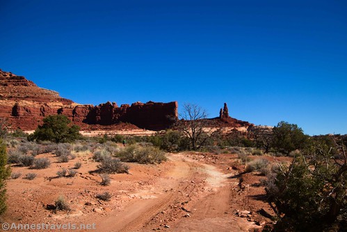
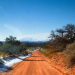
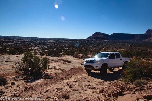
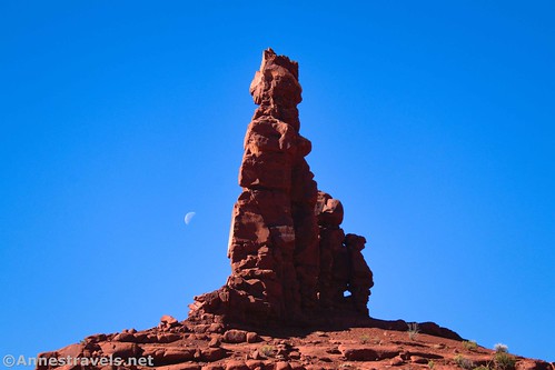
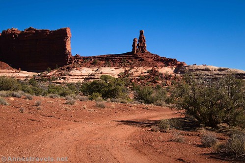
The road at this point isn’t too bad – definitely 4×4, but beyond the bone-jarring, wash-folding-a-jeep-in-two area around Teapot Canyon. You’re heading for the Mother and Child Formation, which has been very visible for most of your descent off of the Golden Stairs.
From this side, my hiking companions decided that it looked more like “the robot and child formation.” It looks more like a mother from the eastern side!
The road rounds the Mother and Child Formation and arrives at the unmarked-by-a-sign Fins Trailhead on the right 0.8 miles from the end of the Golden Stairs Trail. The parking area (which is outlined by small rocks) can hold 2-3 vehicles but was empty on a Wednesday in early November.
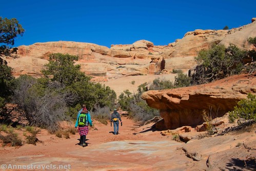
Turn right here to begin down the Fins Trail. I was so excited at this point; I’d wanted to hike the Fins Trail for a long time, and against all odds, we were going to do it! We wouldn’t go all of the way to Ernie’s Country or the Dollhouse (some 8+ miles away), but we would see even a small portion of what I’d read about online.
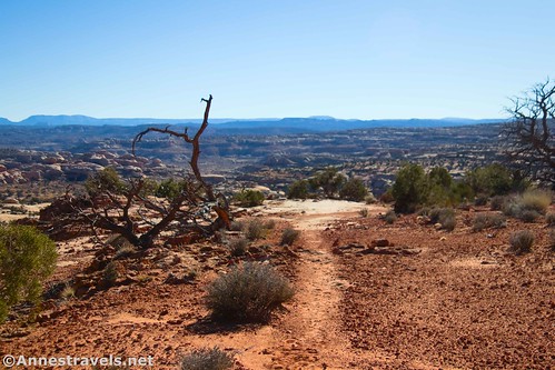
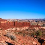
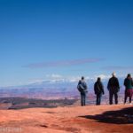
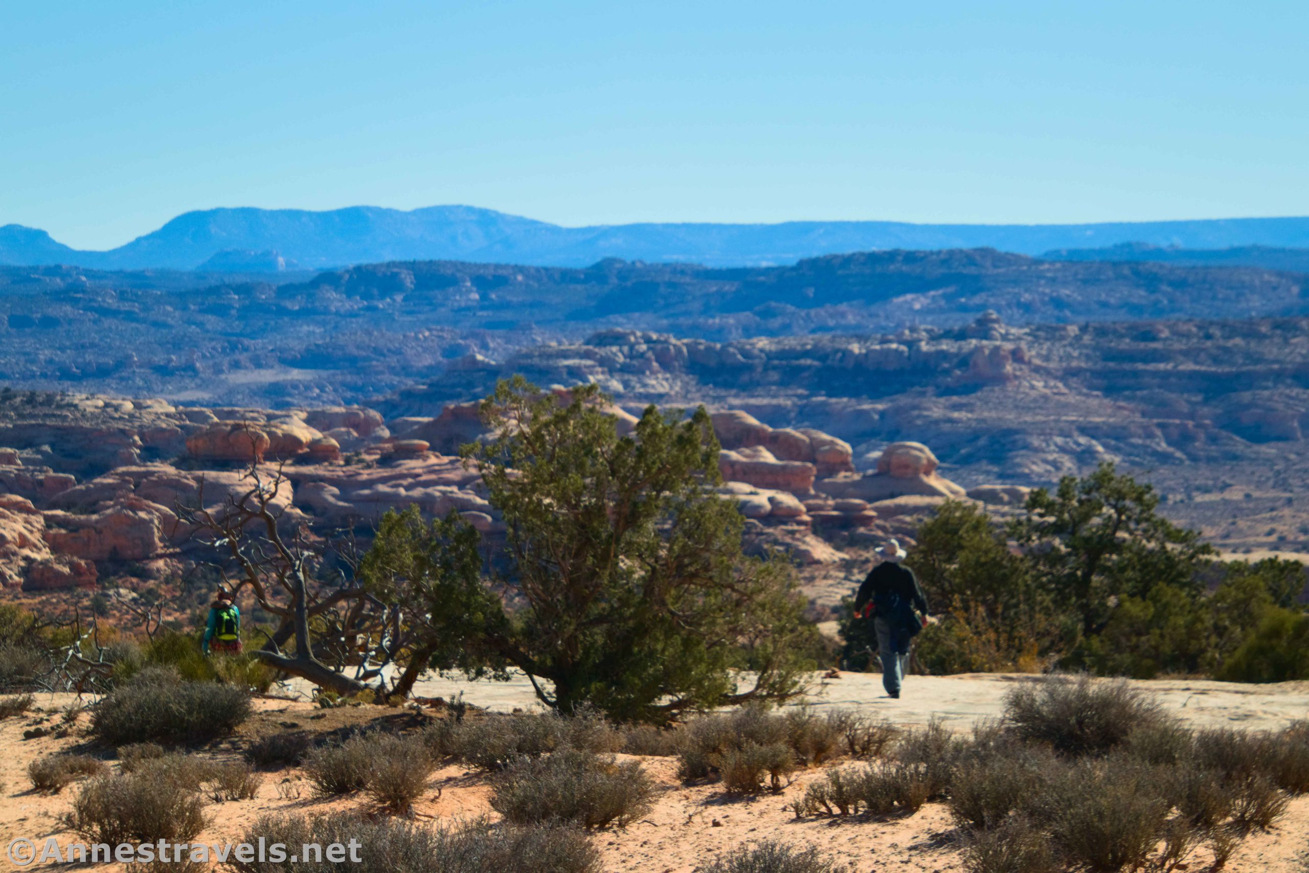
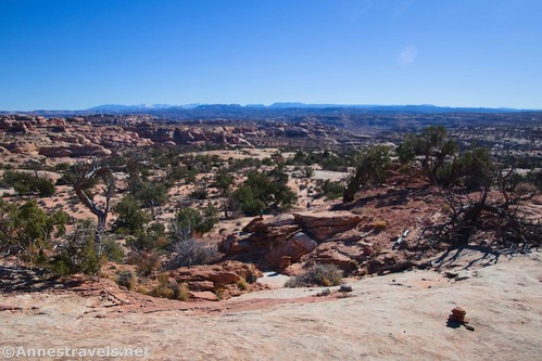
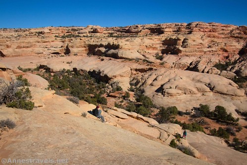
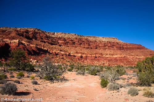
The Fins Trail begins as incredibly scenic. Views stretch south and east to Ernie’s Country, the Land of Standing Rocks (The Wall is especially visible), and the canyons and formations between the two. It was beautiful!

No sign welcomes you to the Maze District proper, but the trail finally crosses the border around mile 0.4. Yay! We’d finally set foot in Canyonlands National Park!
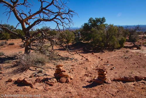
The dirt trail eventually turns to slickrock; follow the cairns (it’s not that hard to follow if you pay attention; without vigilance, you could get lost). At long last, the trail zigzags a little to scramble down a set of watercourses and a natural stone slide down into the canyon.
The stone slide was the most difficult part of the trail – definitely a mild Class 3 scramble. From there, the cairns lead you down into the wash. If you don’t know what you’re doing, the cairns will then lead you across the wash and to Lou’s Spring, tucked away from the main canyon in an alcove. (If you wanted to continue on the Fins Trail, you should have turned right down the wash instead of crossing it to Lou’s Spring.)

I so enjoyed visiting Lou’s Spring – and I’m typically not very interested in desert springs. But this was so peaceful. The drip, drip of the spring. The winter sunlight filtering through the nearby brush. The quiet shadows. The almost absolute stillness. I found it to be a special place.
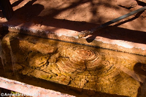
There are three almost-connected watering troughs, with the water dripping out of a pipe. Most people who adventure down in here aren’t doing it on a day hike, so they take advantage of the spring, which often flows year-round (check with the Hans Flat Ranger Station before you rely on this water source). It’s usually more reliable than Clell’s Spring further down the Fins Trail.

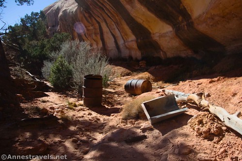
We also found a variety of cowboy litter, but most of it was historic enough that it didn’t trash the place.
I begged to do just one more thing while we in the canyon. After all, we’d come so far, what was another half mile? The resident timekeeper in the group grudgingly gave her consent if we hurried. So we headed back to the main canyon and turned right (upstream).
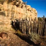
After a tenth of a mile or so, the canyon turned sharply left (west). We went a short distance in this direction until we could scramble up the right (north) wall of the canyon. A shelf about halfway up the cliff allowed us to turn right (east – back downcanyon) to near where the canyon bends to the south. Up in an alcove is a unique granary – it seems to have had a thatched juniper-bark roof.

This is Cedar Bark Ruin. It’s not mentioned very often, and I can see why. It doesn’t need hordes of visitors. Be respectful and keep your distance. Not only is this respect, but it’s also illegal to touch or enter an ancient ruin (my photos were taken with a telephoto lens – the camera had warmed up a little since we’d started hiking).

By now, we were all in a hurry to get back. We had about 5 miles and 1,000ft. of elevation gain to cover – not to mention that we had to turn around and drive back out to BLM land before dark! (We almost made it, and we did make it off the Black Rim in the daylight, which was the really important thing!)

But hey, we set foot in the Maze District before heading home!

Round Trip Trail Length: I went about 10.9 miles from the Overlook on the Golden Stairs Camp Road, down the Golden Stairs, along the Dollhouse Road to the Fins Trail, down the Fins Trail to Lou’s Spring, over to Cedar Bark Ruin, and then back to the Overlook. Just the Fins Trail to Lou’s Spring and Cedar Bark Ruin and back is 2.3 miles.
Elevation Gain: Just the portion of the hike that follows the Dollhouse Road (mostly flat) and the Fins Trail to Lou’s Spring and Cedar Bark Ruin is 885ft. (5,324ft. to 5,045ft.). The entire trail (including the Golden Staircase from the overlook) is 2,529ft. (6,074ft. to 5,045ft.)
Facilities: None
Fees: None

Trail Notes: This hike is much more often done as a backpacking trip. In fact, the I’m not sure I’ve heard of anyone who did the Fins Trail as a day hike – I hear there are some cool canyons to explore along the way (East Fork of Range Canyon and Sand Tank Canyon are the most popular, though Sweet Alice Canyon also looks nice). National park rules apply in terms of overnight camping, etc. The water from Lou’s Spring must be treated before consumption. The bark of the thatched roof is juniper bark, not cedar, despite the name. Lou’s Spring is named after a local rancher; Clell (of Clell’s Spring) was Lou’s Son and Alice (of Sweet Alice Canyon) was Lou’s wife.
Trail 
![]()
![]()
![]()
Road ![]()
![]()
![]()
![]()
Signs ![]()
![]()
![]()
Scenery ![]()
Would I go 100 miles out of my way for this? ![]()
Overall Rating: 
![]()
![]()

GPS Coordinates for the Fins Trail to Lou’s Spring & Cedar Bark Ruin
Overlook (High Clearance Trailhead): 38.1397960°, -110.0889230° (38°08.38776′, -110°05.33538′ / 38°08’23.2656″, -110°05’20.1228″) (6,078ft.) (0.0)
4×4 Parking Area Junction: 38.1442900°, -110.0832740° (38°08.65740′, -110°04.99644′ / 38°08’39.4440″, -110°04’59.7864″) (6,061ft.) (0.48)
Golden Stairs Campsite: 38.1440630°, -110.0831540° (38°08.64378′, -110°04.98924′ / 38°08’38.6268″, -110°04’59.3544″) (6,063ft.) (0.55)
Golden Stairs Trailhead: 38.1439000°, -110.0830410° (38°08.63400′, -110°04.98246′ / 38°08’38.0400″, -110°04’58.9476″) (6,062ft.) (0.56)
China Neck: 38.1434130°, -110.0808100° (38°08.60478′, -110°04.84860′ / 38°08’36.2868″, -110°04’50.9160″) (6,018ft.) (0.72)

Rock with small arch: approximately 38.144378, -110.073950
Begin descent: 38.1444730°, -110.0731520° (38°08.66838′, -110°04.38912′ / 38°08’40.1028″, -110°04’23.3472″) (5,907ft.) (1.25)
Meet wash: 38.1384060°, -110.0828020° (38°08.30436′, -110°04.96812′ / 38°08’18.2616″, -110°04’58.0872″) (5,319ft.) (2.65)
Golden Stairs Trail/Dollhouse Road Junction: 38.1357210°, -110.0788850° (38°08.14326′, -110°04.73310′ / 38°08’08.5956″, -110°04’43.9860″) (5,259ft.) (2.99)
Fins Trailhead on the Dollhouse Road: 38.1395560°, -110.0706450° (38°08.37336′, -110°04.23870′ / 38°08’22.4016″, -110°04’14.3220″) (5,326ft.) (3.81)

Meet Wash/Lou’s Spring Junction: 38.1344570°, -110.0626170° (38°08.06742′, -110°03.75702′ / 38°08’04.0452″, -110°03’45.4212″) (5,049ft.) (4.57)
Lou’s Spring: 38.1358270°, -110.0612880° (38°08.14962′, -110°03.67728′ / 38°08’08.9772″, -110°03’40.6368″) (5,097ft.) (4.75)
Cedar Bark Ruin Viewpoint: 38.1366070°, -110.0627360° (38°08.19642′, -110°03.76416′ / 38°08’11.7852″, -110°03’45.8496″) (5,067ft.) (5.24)
Cedar Bark Ruin: 38.1371470°, -110.0617660° (38°08.22882′, -110°03.70596′ / 38°08’13.7292″, -110°03’42.3576″) (5,142ft.) (5.40)
End: 38.1397920°, -110.0889080° (38°08.38752′, -110°05.33448′ / 38°08’23.2512″, -110°05’20.0688″) (6,077ft.) (10.87)
The gpx file for the Golden Stairs Trail, along the Dollhouse Road, and down the Fins Trail to Lou’s Spring can be downloaded – please note that this and the GPS Coordinates are for reference only and should not be used as a sole resource when hiking this trail. Also note that the map/track shows a short off-trail jaunt I did up to the top of the mesa near the China Neck. There wasn’t much gain for this, though I expect I could have found some nice views down on the Maze if I’d had the time to walk over to the northeast side of the mesa top.
Download GPX File size: 209.0 KB Downloaded 512 times
(Note: I do my best to ensure that all downloads, the webpage, etc. are virus-free and accurate; however, I cannot be held responsible for any damage that might result, including but not limited to loss of data, damages to hardware, harm to users, from use of files, information, etc. from this website. Thanks!)

Getting to the Fins Trailhead
If you want to do this like I did – from the Golden Stairs Trailhead – see my directions on the Golden Stairs Trail Write-up.

If you want to drive to the Fins Trailhead, take the Waterhole Flat Road 30.6 miles from US-95 to the junction with the Dollhouse Road. Turn right toward the Dollhouse. The next 9.75 miles are very, very rough and will require 4×4. Just after rounding the Mother and Child Formation, the Fins Trail will be on the right.

My Favorite Guide to Canyonlands!
This guide to Canyonlands National Park has earned high honors on my list – because it showcases so many hikes that are never mentioned in other guides! It also talks about dirt roads, history, trivia, and so much more. Buy your copy here!