
There are three official overlooks along NP-633, the road between Hans Flat and the Flint Trail in the Maze District of Canyonlands National Park. (If you want to know more about NP-633, be sure to check out this post.) If you happen to be driving the road, all three are well worth stopping to see – especially since none of them take much hiking to get to!
Quick Stats
Note: Some of the links in this post are affiliate links. If you click one and purchase something, I may earn a small commission without an extra cost to you.
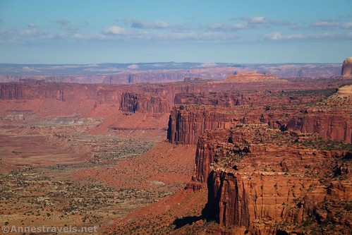
The first viewpoint is the Millard Canyon Overlook. It’s less than a mile from the Hans Flat Ranger Station – so it’s walkable even if you can’t take your vehicle down NP-633 (though why you’d drive all of the way to Hans Flat if you aren’t either driving or backpacking the road…)

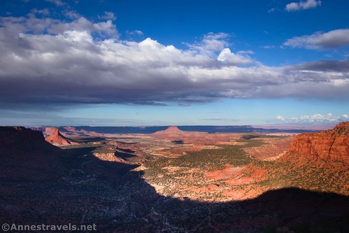
I’d also consider Millard Canyon to be one of the most scenic overlooks in this part of the park. The views are simply stunning down the canyon!

From the sign, walk about 250ft. up the sandy path to the overlook. It’s that simple. Be careful near the edge, though, since there are no railings.

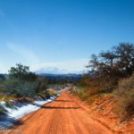
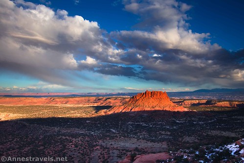
Moving on down NP-633, you’ll pass French Cabin, French Spring, and the North Point Road. From here, it’s a long 6.4 mile drive over mostly easy roads to Bagpipe Butte Overlook, 8.9 miles from Hans Flat.
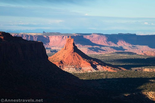
From the sign, walk 250ft. or so on the sandy trail to the viewpoint. Again, it’s just a rock on the edge of the cliff with no railings, so watch yourself.
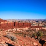
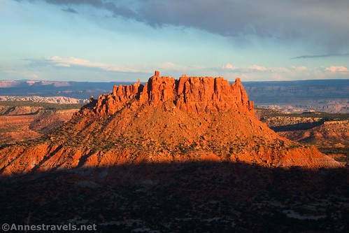
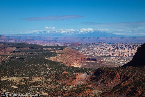
The great thing about this view is that you’re looking at a large butte sticking up out of the plain below. The spires on top of the butte reminded early visitors of the pipes on a church organ or the drones of a bagpipe. I visited late on a November afternoon, so the shadow of the Orange Cliffs was creeping up the side of the butte. I’m glad we didn’t visit any later in the day – or in the morning when the sun would have been behind the butte.
The third viewpoint is the Flint Trail Overlook. It’s 11.8 miles from Hans Flat (and 0.7 miles beyond Flint Seep Camp). The overlook is only 0.5 miles before the end of NP-633 (beginning of the Flint Trail).

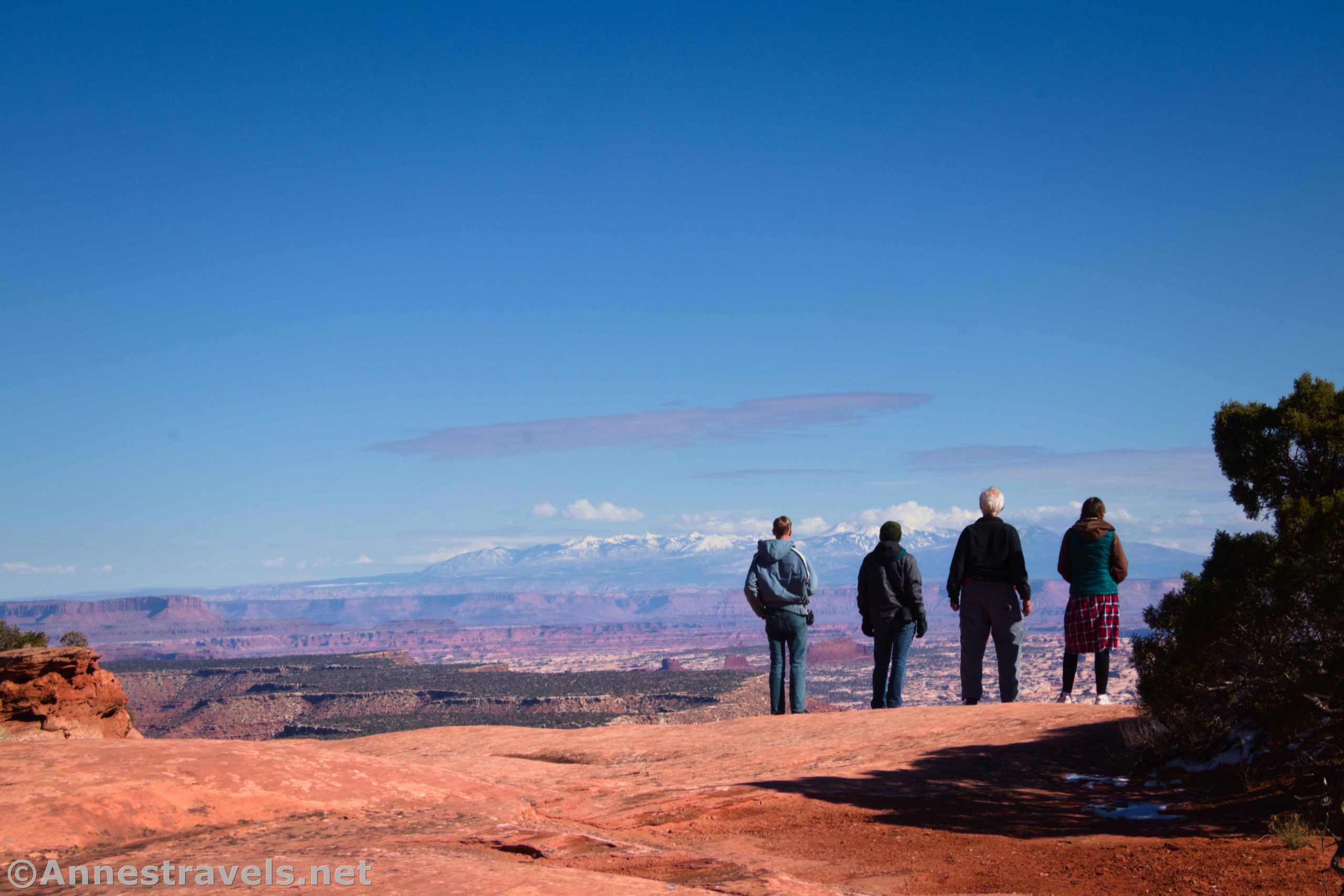
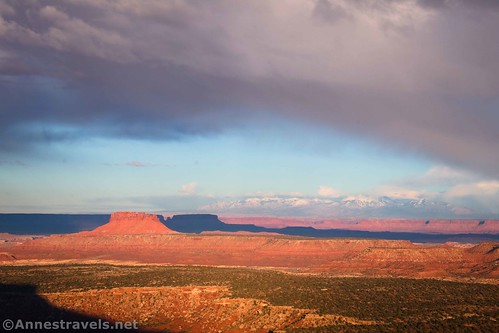
From the pullout, walk maybe 250ft. across the slickrock to the edge of the cliff. From here, you have a clear view down on the switchbacks of the Flint Trail as well as out to the Maze and the formation known as the Mother and Child (along the Dollhouse Road). You can even see into Island in the Sky, the Needles District, and across the way to the La Sal Mountains. Wow!
If you’re planning on driving down the Flint Trail switchbacks, I highly recommend that you stop here first to take a look at them – and possibly decide you’re out of your mind to try such a thing! We watched a Toyota Tacoma go down the switchbacks, and while they were taking it slow (which they should have been; it was pretty snowy), they didn’t seem to be having a lot of trouble on the tight corners – some longer vehicles find themselves having to back up on the sharpest turns.

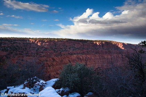
You can wander for quite a distance along the top of the cliffs to the left. The views are slightly different as you go along the edge of the canyon.

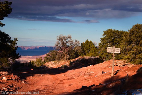
If you want more views, drive another half mile to the top of the Flint Trail (marked by a sign that says, “4×4 Required Beyond This Point” – note that you’ll need to bear left at the Big Ridge Road). A parking space is nearby. If you walk beyond the sign, a rock jutting out just beyond the first curve in the road makes a great place to look out at the Maze!
I got carried away and walked down the Flint Trail switchbacks for a short distance. It was snowy (uncommon but not unheard of for early November), so I didn’t walk far.

Another option for more almost-drive-to-viewpoints is to go to the Neck on the Big Ridge Road – but that’s another topic for another post!
Round Trip Hiking Distance: About 0.3 miles if you do the minimum for all three overlooks. You can go further at the Flint Trail Overlook if desired.
Elevation Gain: Negligible. Millard Canyon Overlook is at 6,542ft., Bagpipe Butte is at 6,624ft., and the Flint Trail Overlook is at 6,841ft.

Facilities: None. The closest restrooms and picnic table are at the Hans Flat Ranger Station.
Fees: None

Trail Notes: While most national parks allow pets in your vehicle and often on roads, the Maze District does not. So even if you plan on just driving through, you’ll need to leave Fido at home. The roads in this part of the Maze really do require 4×4, though I made it ok with my 2WD Ford E150 van and a good spotter (high clearance is helpful!) to the Flint Trail Overlook. While all of the viewpoints are worth seeing, my favorite was Millard Canyon. There are no guardrails at any of the overlooks, so use care next to the sheer drop-offs.
Trail 
![]()
Road ![]()
![]()
![]()
Signs ![]()
![]()
![]()
![]()
Scenery
Would I go 100 miles out of my way for this?
Overall Rating: 
![]()
GPS Coordinates for Millard Canyon Overlook, Bagpipe Butte Overlook & Flint Trail Overlook
Millard Canyon Overlook: 38.2486780°, -110.1687890° (38°14.92068′, -110°10.12734′ / 38°14’55.2408″, -110°10’07.6404″) (6,542ft.)
Bagpipe Butte Overlook: 38.1602510°, -110.1366760° (38°09.61506′, -110°08.20056′ / 38°09’36.9036″, -110°08’12.0336″) (6,624ft.)

Flint Trail Overlook: 38.1216750°, -110.1286370° (38°07.30050′, -110°07.71822′ / 38°07’18.0300″, -110°07’43.0932″) (6,841ft.)
Top of the Flint Trail: 38.1178670°, -110.1245900° (38°07.07202′, -110°07.47540′ / 38°07’04.3212″, -110°07’28.5240″) (6,894ft.)

Getting to NP-633 and Its Overlooks
The easiest way I can describe getting you to NP-633 is to tell you to go read my post on driving the Hans Flat Road. Basically, you want to take Exit 149 off of I-70, turn south, and drive UT-24 for 24.2 miles (or 0.6 miles south of the turnoff for Goblin Valley State Park). Turn left onto the road (it does have a sign for Horseshoe Canyon, Ranger Station, and Doll House 4WD, among other destinations) and drive 45 miles on the dirt road to the Hans Flat Ranger Station.

Drive straight past the Hans Flat Ranger Station, following the small sign for the Flint Trail. Millard Canyon Overlook will be on your left after 0.9 miles. Continue straight on NP-633 (toward the Flint Trail) another 8.0 miles to Bagpipe Butte Overlook on the left. If you drive straight another 2.9 miles, the Flint Trail Overlook will be on your left (if you reach the Big Ridge Road, you’ve gone too far). The end of NP-633 and views at the Flint Trail is 0.5 miles further down the road (take a left at the fork with the Big Ridge Road). For a better description of this route, see my post about NP-633.

All of the viewpoints are just pulloffs by the side of the dirt road – you can often see the signs right about the time you’ve passed them by. So paying attention to your mileage is probably a good idea.

This Week’s Featured Product!
If you’re going to be exploring Canyonlands – an especially the Maze District – I highly recommend this book! It covers 4×4 roads and trails with good maps, history, and more. Buy a copy here!