
It’s not easy to access the true Maze District of Canyonlands National Park. In fact, most of what is known as the “Maze District” is actually the Orange Cliffs District of Glen Canyon National Recreation Area. This includes Hans Flat, the Flint Trail, and most (all?) of the 2WD-accessible roads in the area. So I knew that if we wanted to access the Maze District proper, we’d have to hike. The Golden Stairs Trail seemed to be the shortest 2WD-to-Maze-District route, so that’s what we did.
Quick Stats
As I detailed in my trip report of the Waterhole Flat Road, I don’t actually recommend that 2WD vehicles go beyond Waterhole Flat (in other words, up the Black Rim to the Flint Trail and from there to the Golden Stairs Camp Road). But much of the Maze District is also inaccessible to only rugged jeeps (some say that Teapot Canyon on the Dollhouse Road is one of the roughest drives they’ve ever done), so this route is also a fairly benign 4×4-accessible way into the Maze (though technically, if you kept on driving the Millard Canyon Road toward the Maze Overlook, you would also eventually enter the Maze District without ever leaving your jeep).
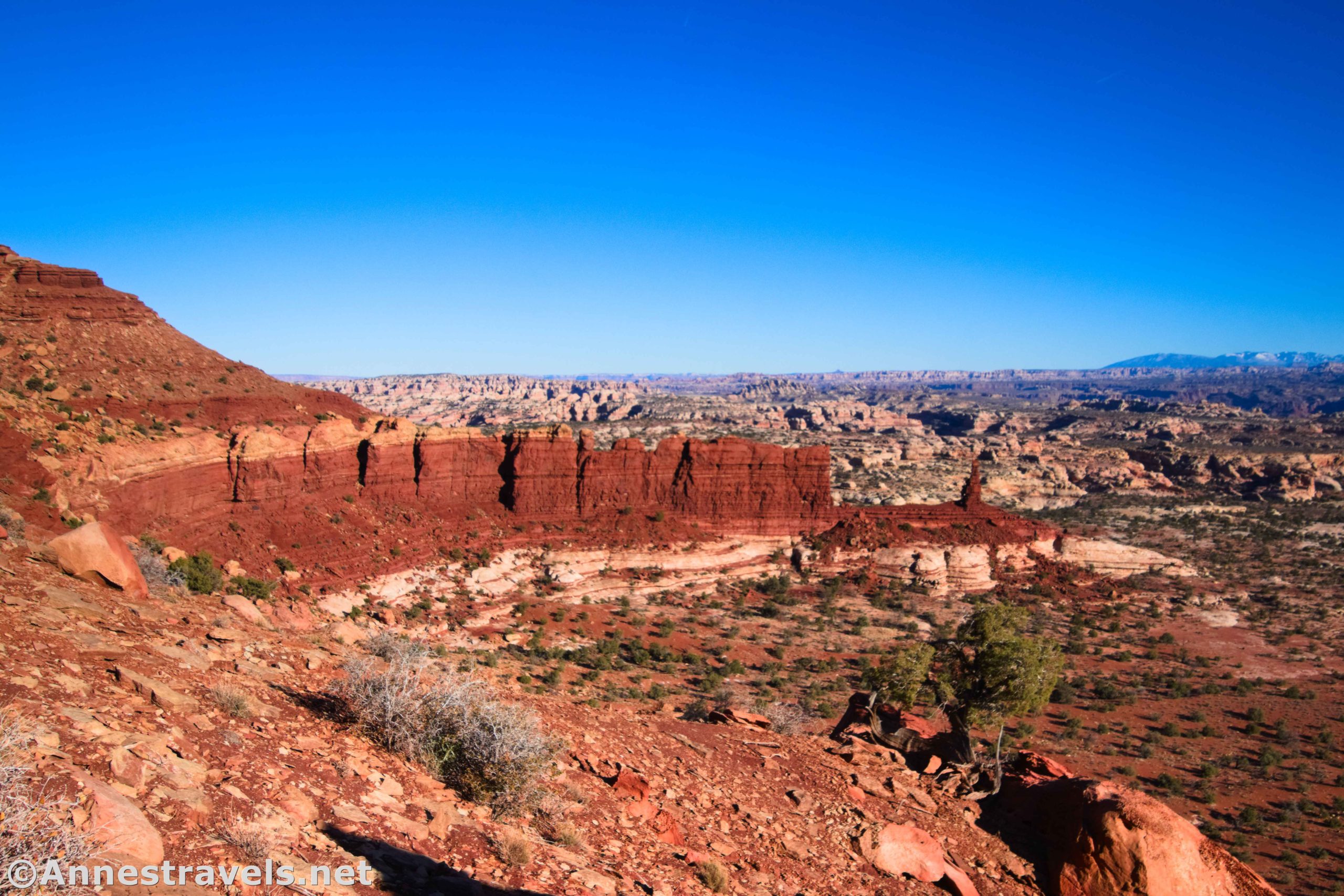
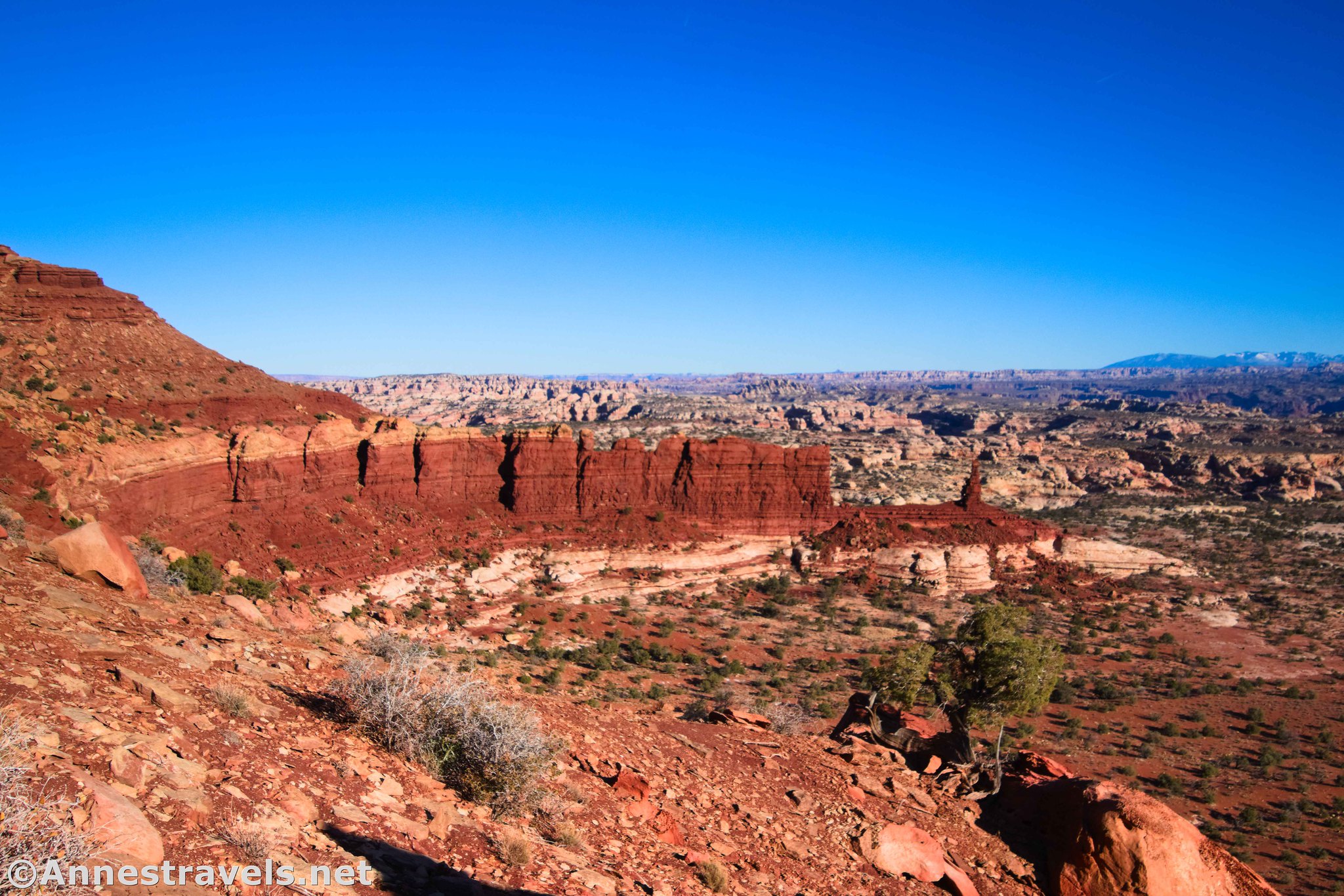
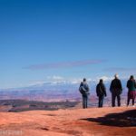
We didn’t quite make it to the Golden Stairs Camp in my 2WD van. The road to the Overlook (a fantastic view down on the Maze, and especially down on the Fins, Ernie’s Country, and the Mother and Child Formation), about half a mile from the Golden Stairs Camp, only had to be rebuilt once or twice with well-placed flat rocks.

The road beyond the overlook declines rapidly (both in repair and literally), so we parked near the overlook and headed out on foot the last half mile or so to the Golden Stairs Camp. At the rough circular parking area, turn right with the road to get to the camp.
The Golden Stairs Trailhead is at the campsite (actually just to the left of the site when facing the site and standing on the access road). It is not marked with a trail sign, but there are a pile of rocks and a sign prohibiting bicycles.

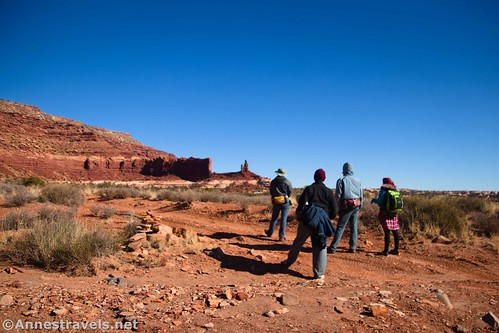
The trail is a little tricky to follow at first, but after a quarter mile, it crosses a narrow causeway of rock between two parts of the mesa. This is known as the China Neck, after the white “porcelain” appearance of the rock.
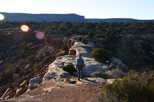
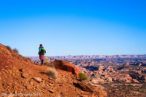
It’s such a cool formation with fabulous views off of both sides. It’s also not for the faint of heart – it’s only about 6ft. wide with steep, significant drops on both sides. Yikes!

Unfortunately, my camera wasn’t liking the sub-32F weather and took a lot of blurry pictures (for all you techy people out there, the aperture wasn’t changing, so I was taking most of my landscape photos at about f/6.3). But hopefully you can get an idea of how cool this is from the pictures I took on our way back that evening!

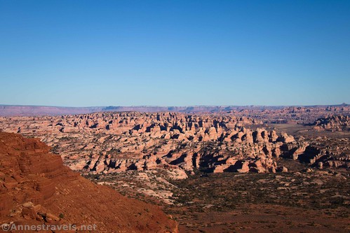
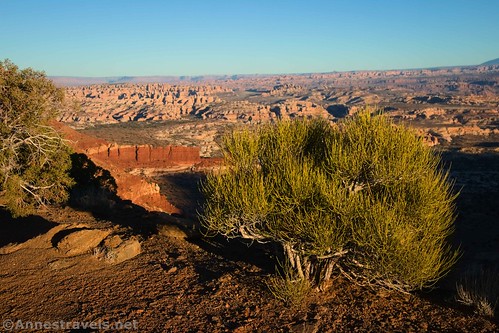
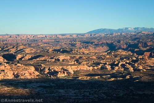
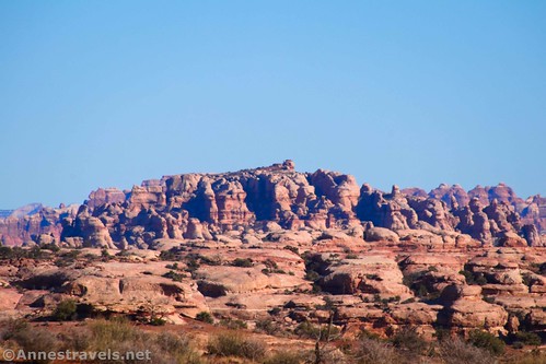
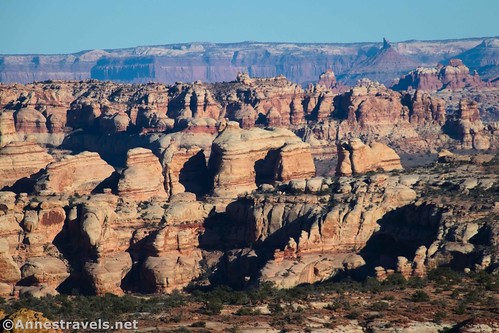
From here, the trail strikes off across a shelf of the mesa for about half a mile (follow the cairns; it’s not hard to find). The views are good down on Ernie’s Country from here. I should note that no one knows who Ernie was or what he did to have the area south of the Fins named after him. It became a joke among my fellow hikers; if a formation didn’t have a name, of course it adopts the name of the evasive Ernie!

We also found a rock with pretty cool holes in it.
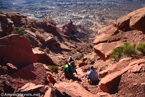
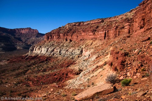
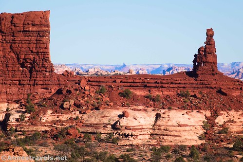
About 1.25 miles from the overlook (0.7 miles from the Golden Stairs Trailhead), the trail turns right to drop over the edge of the cliff. It’s quite the trail, descending about 600 vertical feet in about 1.3 miles – with great views the entire time to the Mother and Child Formation, not to mention the Dollhouse, the Needles, the La Sal Mountains, the fins, Ernie’s Country, and much, much more.
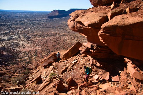
The trail looks like it doesn’t exist until you’re right on top of it. It’s literally hewn out of the rock at times, and in other places, it’s nearly a rock scramble. So much for the stroll in the park that’s comprised the trail before this!

The Golden Stairs Trail was built by early ranchers around 1900 to move sheep or cattle between Ernie’s Country and Elaterite Basin. At times, I could see where the old trail had gone, but the NPS has moved the trail to make it easier/less likely to erode.
Again, the route is marked by cairns. If you lose your way, backtrack to find the last cairn or stand still until you can locate the next cairn.

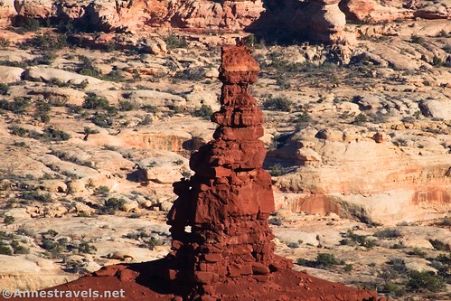
The Golden Stairs, itself, is the gold-colored cliff that you’re descending. In the afternoon light, it can look a little like a cracked gold staircase.

About mile 2.6 (from the overlook; 2.1 from the TH), the trail drops into a wash. It’s a simple matter of turning left and following the wash downstream.

Only 0.4 miles after dropping into the wash (3.0 miles from the overlook and 2.5 miles from the TH), the wash crosses the Dollhouse Road. This is the end of the Golden Stairs Trail.
But we still had to get to the Maze District (this portion of the Dollhouse Road is still in Glen Canyon NRA). So we turned left… but that’s a topic for another post, because it’s just that exciting to see!

Round Trip Trail Length: 5-6 miles RT to hike only the Golden Stairs Trail; I went a total of 10.9 miles that day with all of my exploring.
Elevation Gain: Just the Golden Stairs Trail from the overlook is 1,641ft. (6,074ft. to 5,257ft.). The entire hike (including along the Dollhouse Road and down the Fins Trail to Lou’s Spring) is 2,529ft. (6,074ft. to 5,045ft.)
Facilities: None
Fees: None

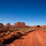
Trail Notes: This isn’t exactly a stroll in the park, nor is it suited for those with a fear of heights. I didn’t find the scramble too difficult (other than being steep), but it is definitely a Class 2+ scramble. Bring plenty of water with you (there’s none out here) as well as more than enough gas to get you to the trailhead and back out to Hanksville. The Golden Stairs Trail is very exposed, a southern-facing slope, and would be very hot on a summer day. I highly recommend taking the Dollhouse Road over to the Mother and Child formation… or even down the Fins Trail to Lou’s Spring if you have the time and energy.

Trail 
![]()
![]()
![]()
Road ![]()
![]()
![]()
![]()
Signs ![]()
![]()
![]()
![]()
Scenery
Would I go 100 miles out of my way for this?
Overall Rating: ![]()
![]()
GPS Coordinates for the Golden Stairs Trail
Overlook (High Clearance Trailhead): 38.1397960°, -110.0889230° (38°08.38776′, -110°05.33538′ / 38°08’23.2656″, -110°05’20.1228″) (6,078ft.) (0.0)
4×4 Parking Area Junction: 38.1442900°, -110.0832740° (38°08.65740′, -110°04.99644′ / 38°08’39.4440″, -110°04’59.7864″) (6,061ft.) (0.48)
Golden Stairs Campsite: 38.1440630°, -110.0831540° (38°08.64378′, -110°04.98924′ / 38°08’38.6268″, -110°04’59.3544″) (6,063ft.) (0.55)
Golden Stairs Trailhead: 38.1439000°, -110.0830410° (38°08.63400′, -110°04.98246′ / 38°08’38.0400″, -110°04’58.9476″) (6,062ft.) (0.56)
China Neck: 38.1434130°, -110.0808100° (38°08.60478′, -110°04.84860′ / 38°08’36.2868″, -110°04’50.9160″) (6,018ft.) (0.72)
Rock with small arch: approximately 38.144378, -110.073950
Begin descent: 38.1444730°, -110.0731520° (38°08.66838′, -110°04.38912′ / 38°08’40.1028″, -110°04’23.3472″) (5,907ft.) (1.25)
Meet wash: 38.1384060°, -110.0828020° (38°08.30436′, -110°04.96812′ / 38°08’18.2616″, -110°04’58.0872″) (5,319ft.) (2.65)
Golden Stairs Trail/Dollhouse Road Junction: 38.1357210°, -110.0788850° (38°08.14326′, -110°04.73310′ / 38°08’08.5956″, -110°04’43.9860″) (5,259ft.) (2.99)
End: 38.1397920°, -110.0889080° (38°08.38752′, -110°05.33448′ / 38°08’23.2512″, -110°05’20.0688″) (6,077ft.) (10.87)
The gpx file for the Golden Stairs (plus the Fins Trail to Lou’s Spring) can be downloaded – please note that this and the GPS Coordinates are for reference only and should not be used as a sole resource when hiking this trail. Also note that the GPX shows a little scramble I did just beyond the China Neck up onto the nearby mesa. This was a sketchy Class 3 climb without a lot of rewards… though if I’d had more time, I expect I could have gotten some good views down into the Maze from the northeastern side of the mesa top.
Download GPX File size: 209.0 KB Downloaded 479 times
(Note: I do my best to ensure that all downloads, the webpage, etc. are virus-free and accurate; however, I cannot be held responsible for any damage that might result, including but not limited to loss of data, damages to hardware, harm to users, from use of files, information, etc. from this website. Thanks!)
Getting to the Golden Stairs Trailhead
You want to get to the junction of the Flint Trail, the Waterhole Flat Road, and the Millard Canyon Road. You can do this by 1) taking the Waterhole Flat Road 37.4 miles from US-95 near Hite, or 2) driving NP-633 from Hans Flat Ranger Station and then descending the Flint Trail. From this junction, turn onto the Millard Canyon Road (toward the Maze Overlook).

Exactly 1 mile from the junction, turn right onto the dirt road marked for the Golden Stairs Camp. After 0.5 miles, an overlook will open up on the right – if you’ve managed to make it this far with only 2WD and high clearance (I did it, but I can’t say I recommend it), park here. If you have 4×4, enjoy the view and then continue another half mile to a sharp right turn in the road. Near here is the “parking area” (it didn’t look fun to me!) for the trail. Turning right with the road will bring you to the trailhead and the campsite a tenth of a mile later.

Hike the Maze!
Explore the most famous hikes in the Maze, as well as in the rest of Canyonlands National Park, in this book. More than 60 trails in Canyonlands and Arches showcase some of the best scenery in both parks. Buy your copy here!


One response to “Golden Stairs Trail into the Maze District”
[…] few days ago, I wrote about hiking down the Golden Stairs Trail and (almost) into the Maze District of Canyonlands National Park. After we had descended to the Dollhouse Road, we decided that we 1) hadn’t had enough […]