
Arizona
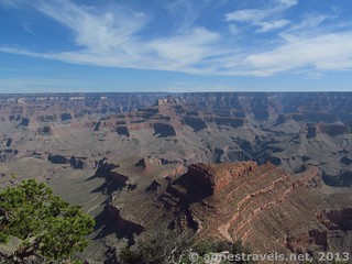
Shoshone Point
2 miles RT; 313ft. vertical change; Easy to Moderate
To get to Shoshone Point, walk down a dirt road to an area most often used for Grand Canyon weddings, then beyond to the point for some truly spectacular views of the canyon. The area is very uncrowded except when an event is in progress (at which point, you probably don’t want to do the hike – more information here).
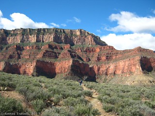
South Kaibab/Tonto/Bright Angel Loop
About 13.1 miles RT; 3,395ft. vertical change; Very Difficult
Take the free park shuttle bus to Yaki Point, then descend via the spectacular South Kaibab Trail (a worthy destination unto itself!) At the “Tipoff Point” (4.4 miles from the rim), turn left (west) on the Tonto Trail. The trail is fairly flat, traversing the plateau between the inner and outer canyon, for about 4 miles to the Bright Angel Trail. Turn left on the Bright Angel Trail a quarter mile or so up to Indian Gardens (including water spigots in late April through early October) and then continue up to the rim and take the free park shuttle bus back to your vehicle. Views are spectacular of the Grand Canyon, the Colorado River is visible in places, and you get the experience the canyon from within. Full description here.
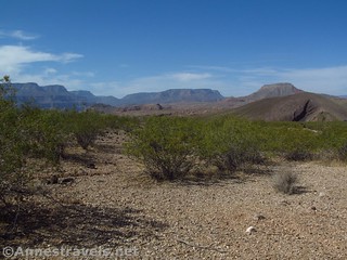
Whitmore Trail
Driving adventure; hike is 2.2 miles RT; 872ft. vertical change; Moderate
Looking for a real adventure? Take the Whitmore Trail (high clearance required, 4×4 likely required) to the Whitemore Trail Trailhead and then hike down to the Colorado River on what is likely the easiest rim-to-river trail in the canyon. From the Mt. Trumble Schoolhouse, you can also drive over the mountains to the Toroweap area (high clearance likely required)
New Mexico
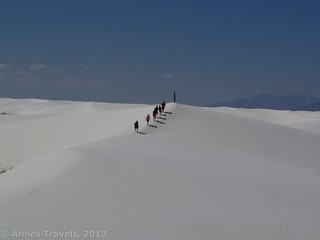
White Sands National Monument
Varies – exploration is encouraged!
White Sands is a great place to explore, whether you’re 4 or 84. Jump or slide down the pure white dunes (it really feels like you’re playing in warm snow), have a picnic, or take a ramble through the ever-changing scenery (compass and a good sense of direction highly recommended). Looking for more excitement? Check out the nearby White Sands Missile Range (ID required for admission for adults; more info here).
Texas
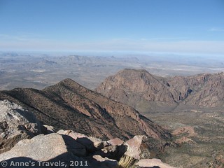
Emory Peak
9 miles out & back; 2,448ft. vertical change; Very Difficult
The trail up Emory Peak passes up through forests with occasional views up to the peaks of the Chisos Mountains, then turns up to the peak up a near-rock scramble to views down on Chisos Basin and across the Texas plains.
Idaho
Bald Mountain
7.6 mile out & back; 2183ft. vertical change; Moderately Difficult
The Station Creek Trail rises to the ridge, then continues up to Bald Mountain. The offers ample views over the surrounding mountains and valleys, as well as wildflowers in season (maybe a little later than April, but still a great hike this time of year).
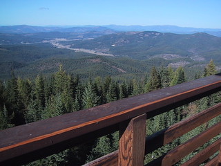
Mineral Ridge National Recreation Trail

2.8 mile loop; 501ft. vertical change; Moderate
The Mineral Ridge National Recreation Trail has some truly spectacular scenery. Located near Coeur d’Alene, the trail accesses three viewpoints and several picnic spots as well as views over the lake.
Montana
Lava Lake

6 miles out & back; 1,591ft. vertical change; Moderately Difficult
Get in some stunning mountain views and an alpine lake – early in the season – at Lava Lake not far from Bozeman. The trail generally follows Cascade Creek, making it an even more pleasant adventure.
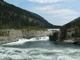
Kootenai Falls & Swinging Bridge
About 1.5 miles RT; 158ft. vertical change; Moderate
Take the trail from Kootenai Falls County Park to the concrete bridge over the train tracks, then follow the two spurs – one to the waterfall viewing area and the other to the swinging bridge high above the Kootenai River. Which is more fun? You’ll have to decide for yourself!
Wyoming
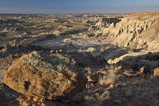
Adobetown Wilderness Study Area
Varies widely
If you want somewhere to explore, down the line of Bisti or maybe Badlands National Park, check out the Adobetown Wilderness Study Area not far north of the Colorado boarder in the western portion of the state. Lose yourself in the badlands, washes, and rock formations – but make sure you can find your way back to your vehicle.
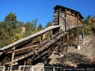
Aladdin Tipple
Less than 0.5 miles; short climb (optional); Easy
A “tipple” is used in coal mining, and the Aliddan Tipple was built in the late 1800s and then used until it was abandoned in 1942. It has been restored and is a great history lesson (more fun, of course, because it’s not in a dusty textbook).
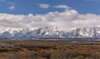
Grand Teton National Park by Bike
Both Yellowstone and Grand Teton offer vehicle-free, snow-free roads between snow-season and car-season. It’s a great time to get out your bike and go for spin in some truly beautiful scenery!
Colorado
Gem Lake
3.5 mile out & back; 990ft. vertical change; Moderate
The Rockies are much prettier with snow on them, and the Gem Lake Trail in Rocky Mountain National Park does the views justice. Hike through a boulder-strewn canyon, then ascend to views over the Rockies and Estes Park before arriving at the lake. Extend the hike via the Lumpy Ridge Trail for an 11 mile loop.
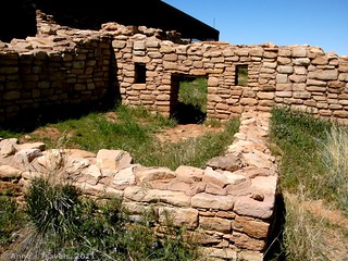
Lowery Pueblo
0.25 miles; negligible vertical change; Easy
You’ll have to get off the beaten path a bit to get to Lowery Pueblo in Canyon of the Ancients National Monument, but that’s not all bad. A short path leads around the remains of the pueblo, as well as inside a covered portion. It’s quite the place!
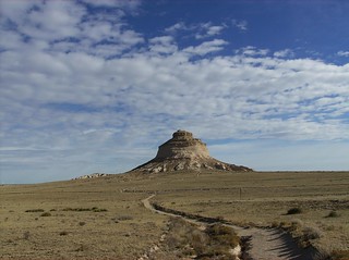
Pawnee Buttes
4.1 miles; 215ft. vertical change; Easy
Pawnee Buttes is an excellent place to enjoy spring on the plains. The path leads to the buttes, then dips down to the prairie floor before arriving at the second butte.