
Washington
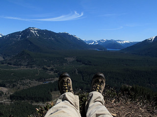
Rattlesnake Ledge
4.0 miles RT; 1,160ft. vertical change; Moderate
Enjoy an early-season hike up Rattlesnake Ledge just south if I-90 and east of Snoqualmie Pass. Views extend across the Cascades, Mt. Si, Snoqualmie Pass, and more. If energy and conditions allow, continue on to East Peak (8.8 miles RT).
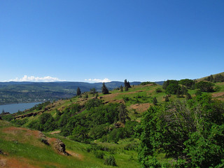
Coyote Wall – Labyrinth Loop
7.7 mile loop; 1,200ft. vertical change; Difficult
For views over the Columbia Gorge and spring wildflowers, check out the Coyote Wall-Labyrinth Loop. The trail can be difficult to follow in places, so only attempt if you plan on a bit of adventure.
Mount Muller
10.3 mile out & back or 12.0 mile loop; 2,732ft. vertical change; Difficult
Mount Muller in Olympic National Park is an early trail to thaw out, but it also offers spectacular views of the Olympics early in the season. The trail switchbacks upward into meadows, offering ever-increasing views, up to the heavily forested summit of the peak. For a loop option, continue on the descent to Mosley Gap and back to the trailhead.
Oregon
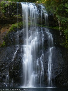
Trail of Ten Falls
7.1 mile loop; 1,095ft. vertical change; Moderately Difficult
The Trail of Ten Falls in Silver Falls State Park delivers exactly what it says – ten waterfalls of varying heights and shapes. You can also drive to several of the falls if you want a shorter hike. Use care as the trails may be muddy after a heavy rain. My favorite falls are Lower South Falls, North Falls, and Upper North Falls.
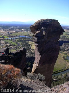
Misery Ridge Loop
3.8 mile loop; 1,115ft. vertical change; Moderate
Smith Rock State Park is a not-so-overlooked gem when it comes to rock formations. Take the Misery Ridge Loop up to the top of the rocky rim, with great views down on the surrounding area, then across the top to views of the Monkey Face (a favorite with rock climbers). The trail descends steeply back down to the river’s edge to follow the river back to the parking area.
California
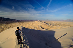
Kelso Dunes
About 3 miles (out & back); 470ft. vertical change; Moderate to Difficult
At the Kelso Dunes in Mojave National Preserve, you can hike to the tallest point in the dune field – which is bigger than Death Valley’s famed dune areas. And on top of that, you get views of the surrounding area.
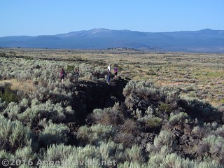
Big Crack
Varies – at least 1 mile; about 77ft. vertical change; Difficult
There’s nothing simple about hiking the Big Crack – there isn’t even a trail – but in the cooler temperatures of April in NorCal, you get to experience the volcanic past of Lava Beds National Monument by walking along a fault line. The shifting faults have created a slot canyon, which can be explored, along with plenty of piles of hardened lava. And the views to Mt. Shasta are exceptional!
Nevada
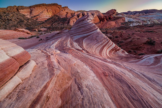
Fire Wave Trail
1.5 miles out & back; 175ft. vertical change; Easy to Moderate
Enjoy stripes and swirls in the slickrock along the Fire Wave Trail in Valley of Fire State Park. It’s somewhat reminiscent of the famous “Wave” in Kodachrome Basin, but without the permit lottery.
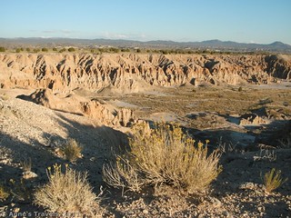
Miller Point to Cathedral Gorge State Park
1+ miles out & back; 130ft. vertical change; Easy to Moderate
The caves of Cathedral Gorge State Park are crazy-cool, and one of the benefits of parking at Miller Point is that 1) you get a view over the caves as well as inside of them, and 2) you get to hike through the washes and formations en route to the state park. Once at the park, you can explore the various caves and formations, some of which are more accessible than others.
Utah
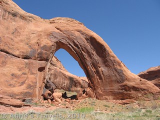
Broken Bow Arch
4+ miles out & back; 450ft. vertical change; Moderate
Hike the winding desert canyons of Glen Canyon National Recreation Area to Broken Bow Arch off of the Hole-in-the-Rock Road. The arch is huge, soaring out from the wall of the canyon, while a stream placidly flows around its base. Extend the hike by walking downstream to several waterfalls and other rock formations.
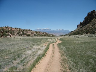
Hidden Valley
4.8-6.6 miles out & back; 673ft. vertical change; Moderately Difficult
For idyllic views of the La Sal Mountains, one of my favorite viewpoints is from Hidden Valley south of Moab. The trail steeply ascends the side of the cliff, then levels in the grassy desert meadow. Petroglyphs can be located at the far end of the valley.
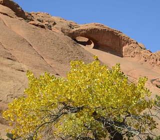
Upper Muley Twist
9 mile loop (14 miles without high clearance); 850ft. elevation change; Difficult to Very Difficult
Getting to the trailhead for Upper Muley Twist is an adventure unto its own, but you’ll pass multiple arches along the way, even before you park your jeep. Then pack up and head out for canyons, fins, arches, and sweeping vistas – all in relative solitude.