
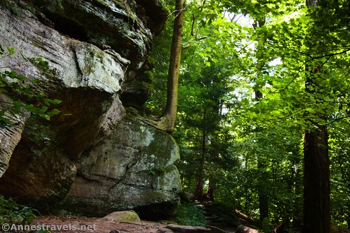
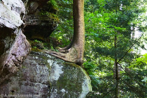
If there’s one trail in Cuyahoga Valley National Park that you shouldn’t miss, it’s the Ledges Trail. Besides being a nice hike in its own merit, it showcases what some would call “bluffage” – huge rocks and cliff faces, often with fun cracks, caves, and even balancing rocks and arches. The Ledges Trail takes you to quite a few interesting features along its cliffs, so it’s well worth the time to drive from the main part of the park to the trailhead.
Quick Stats
Note: Some of the links in this post are affiliate links. If you click one and purchase something, I may earn a small commission without an extra cost to you.
The trail begins as a paved old road. Pass by the lodge. The road becomes dirt and arrives at a four-way junction about a quarter mile from the trailhead. Despite the sign saying to turn right for the Ledges Trail, we continued straight. If you’re looking for the fastest, see-the-best-stuff hike, you’d want to turn right here and then left on the Ledges Trail. However, we decided to drop down into the middle of the best section of cliffs via the Stone Steps and catch the rest of the best features of the trail on our way back.

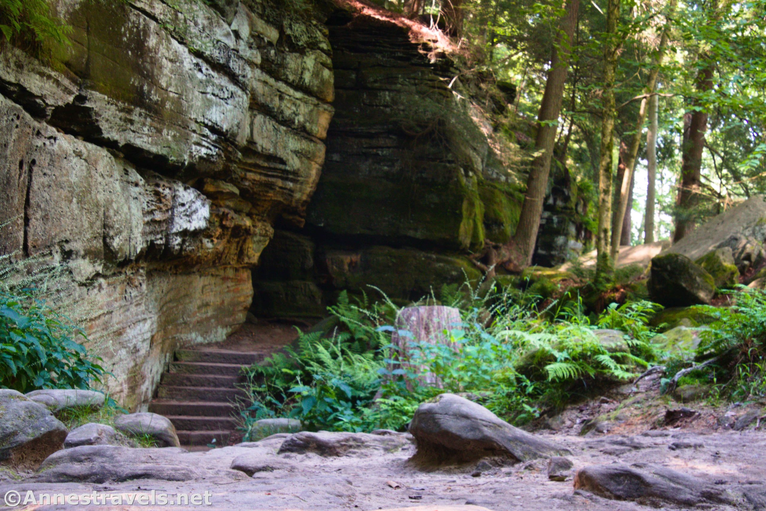
Continue straight and downhill on the old road; the next trail junction is a T about a tenth of a mile later. Turn right here to descend the “stone steps.” I’m guessing these were constructed either by the CCCs (who did extensive work in the area) or else by German POWs during WWII – nearby stone walls seem to have a similar origin. Either way, it’s a fun and beautiful addition to the hike.

At the bottom of the Stone Steps, we turned left. There are some nice cliffs and “bluffage” in this area, though nothing spectacular.

A short distance later, a trail goes off on the right. We misinterpreted the sign and turned right toward Happy Days (as in Happy Days Lodge). We walked a tenth of a mile to the Haskell Run Junction and then left another tenth of a mile down to Haskell Run before hearing traffic and realizing our mistake. So then it was a quick uphill trek back to the Ledges Trail. (All that to say: go straight/left at this junction and you won’t walk an extra half mile!)

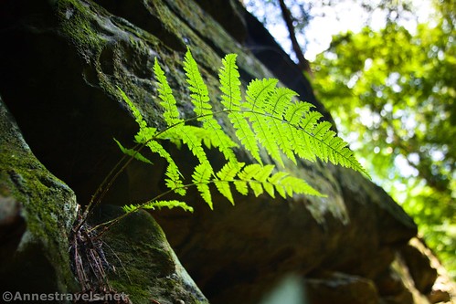
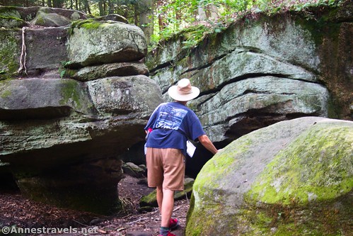
About a tenth of a mile after the junction for Happy Days Lodge, pass a trail on the left (this would take you back up to the top of the Stone Steps). But this is a great tenth of a mile! The bluffage is spectacular, and there’s even a cleft in the rock that will allow you to explore more fully. Take your time – it’s a great area!

Two more trails go off over the next 0.3 miles before the next major junction on the right pointing toward the Octagon Shelter and the viewpoint 2/3 of a mile straight ahead (the side trails would take you either right down toward the Octagon Road or else left up to the top of the cliffs). At this major junction, walk up the stairs and straight ahead toward the Viewpoint.

This next section was not my favorite; while there are still cliffs, they’re not as spectacular as what you’ve seen up to this point. About half a mile beyond the last of the Octagon signs, the Pine Grove Trail strikes off to the right. Take the Ledges Trail left toward the viewpoint.

Less than a tenth of a mile later, turn left up the steep trail to the Overlook. Actually, you could take a slightly gentler slope by going straight on the Ledges Trail and turning left a short distance later. But we trusted the signs and struck left up to the overlook. It’s not too hard to find the overlook, even if there are several trails converging on each other from multiple directions in the area.
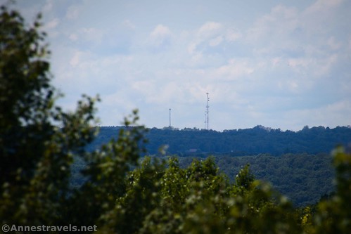
Views from the overlook aren’t what I’d call epic, but they’re not bad, either. Various rows of hills are visible as well as a few communication towers and a few buildings. To be honest, it’s a little grown in; walk around to find the best places to see over and around the trees. The park must trim back the trees from time to time or else the view would be completely obscured.

The next tricky part was getting back on the Ledges Trail. We could have retraced our steps down the steep hill; instead, we went up to the picnic table and turned right, following the sign for Ice Box Cave. Whatever you do, don’t be tempted to walk out into the field that’s visible through the trees and via a trail – walking across the field would take you straight back to the parking lot. We hadn’t yet seen the best of the bluffage/cliffs yet, so we took the trail down to cross the road and into the forest beyond.

The forest section definitely is not the most interesting part of the loop. We did see a few deer; unfortunately, my camera had been acting up most of the afternoon, so I didn’t get the best shots. (The lens would fall apart completely the next day on the Towpath, but a trip to Walmart for a tiny screwdriver fixed the issue – yay!) At long last, the cliffs begin to appear in profusion.
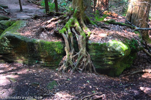
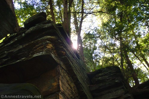
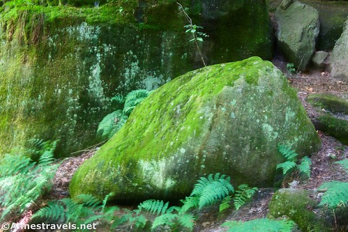
Arrive at a trail junction about half a mile from the road crossing. This marks the beginning of the best part of the Ledges Trail. The cliffs are impressive, several areas allow for exploration, the trees overhang the mossy boulders – wow!
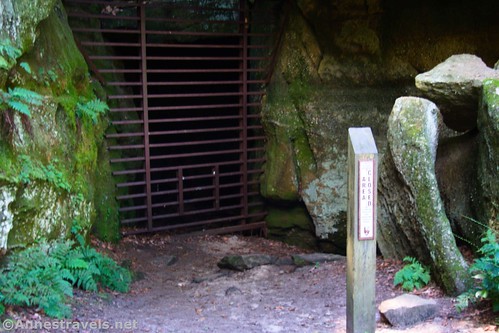
A tenth of a mile after the trail junction, a side trail on the left leads to Ice Box Cave. You can’t go inside (to protect the bats), but the area outside of the cave is pretty.
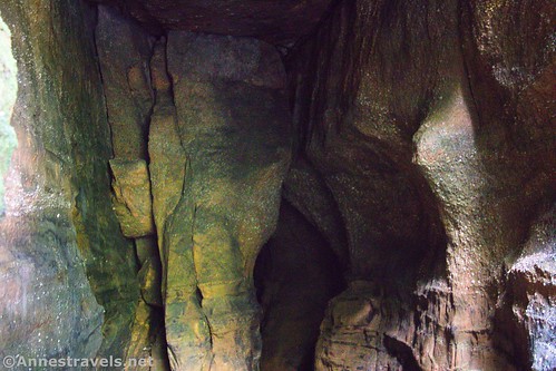
Another exploration area after the cave combines mossy boulders with trees, ferns, and bluffage. It’s incredible to me just how sheer some of these cliffs can be!

A short 0.3 miles after Ice Box Cave, return to the bottom of the Stone Steps. This is the end of the loop portion of the trail, so turn left up the stairs, left at the top to ascend the old road, and finally pass the Ledges Shelter and back to the parking lot.
Overall, I hiked 3.6 miles (which means it’s probably about 3.0 miles without the detour down Haskell Run). We did a little bit of exploring among the boulders and cliffs and sat for a few minutes up near the Overlook to have a snack. It’s a hike I’d totally do again if I happened to be in the area!
Round Trip Trail Length: About 3 miles
Elevation Gain: 663ft. (1,055ft. to 941ft.)
Facilities: Restrooms at the trailhead; picnic tables and (possible) restrooms near the overlook
Fees: None
Trail Notes: I’d say the Ledges Trail is one of the gems of Cuyahoga Valley National Park. (The Tow Path would also get this stamp of approval if you like to bicycle.) Wear good shoes, as the trail surface can be rough around the cliffs. Be sure to poke into the cliff areas – but keep an eye on your hands and feet (you don’t want to meet a snake or spider by accident!) The term “bluffage” was, as far as I can tell, coined by Hiking with Shawn, a great site about hiking in Shawnee National Forest and state parks in southern Illinois. If you want a short-but-all-the-best hike, go to the first trail junction and turn right. Once on the Ledges Trail, turn left, walk around past the Stone Steps, and then ascend via the trail that takes you up to the top of the Stone Steps. Turn right back up the old road to return to the parking lot. RT milage would be about 1.2 miles.

Trail 
![]()
![]()
Road ![]()
Signs ![]()
Scenery ![]()
Would I go 100 miles out of my way for this? ![]()
Overall Rating: ![]()

GPS Coordinates for the Ledges Trail
Trailhead: 41.2236310°, -081.5101690° (41°13.41786′, -081°30.61014′ / 41°13’25.0716″, -081°30’36.6084″) (1,053ft.) (0.0)
Four-way Trail junction: 41.2266540°, -081.5101810° (41°13.59924′, -081°30.61086′ / 41°13’35.9544″, -081°30’36.6516″) (1,031ft.) (0.22)
Happy Junction: 41.2283780°, -081.5107520° (41°13.70268′, -081°30.64512′ / 41°13’42.1608″, -081°30’38.7072″) (999ft.) (0.35)
Bottom of stairs: 41.2284660°, -081.5098850° (41°13.70796′, -081°30.59310′ / 41°13’42.4776″, -081°30’35.5860″) (951ft.) (0.45)
Happy Junction: 41.2287980°, -081.5106710° (41°13.72788′, -081°30.64026′ / 41°13’43.6728″, -081°30’38.4156″) (946ft.) (0.51)
Haskill Run Junction: 41.2295240°, -081.5098550° (41°13.77144′, -081°30.59130′ / 41°13’46.2864″, -081°30’35.4780″) (876ft.) (0.60)

Trail Junction: 41.2282160°, -081.5119140° (41°13.69296′, -081°30.71484′ / 41°13’41.5776″, -081°30’42.8904″) (965ft.) (1.16)
Trail Junction: 41.2267550°, -081.5127760° (41°13.60530′, -081°30.76656′ / 41°13’36.3180″, -081°30’45.9936″) (990ft.) (1.30)
Trail Junction: 41.2263170°, -081.5127880° (41°13.57902′, -081°30.76728′ / 41°13’34.7412″, -081°30’46.0368″) (1,004ft.) (1.33)
Oct. Parking Trail Junction: 41.2257960°, -081.5133510° (41°13.54776′, -081°30.80106′ / 41°13’32.8656″, -081°30’48.0636″) (978ft.) (1.39)
Pine G. Junction: 41.2194810°, -081.5117750° (41°13.16886′, -081°30.70650′ / 41°13’10.1316″, -081°30’42.3900″) (985ft.) (1.89)
Overlook Junction: 41.2196260°, -081.5113940° (41°13.17756′, -081°30.68364′ / 41°13’10.6536″, -081°30’41.0184″) (1,007ft.) (1.92)
Overlook: 41.2203780°, -081.5120950° (41°13.22268′, -081°30.72570′ / 41°13’13.3608″, -081°30’43.5420″) (1,040ft.) (1.99)

Trail Junction: 41.2208050°, -081.5119550° (41°13.24830′, -081°30.71730′ / 41°13’14.8980″, -081°30’43.0380″) (1,047ft.) (2.20)
Cross road: 41.2209440°, -081.5102820° (41°13.25664′, -081°30.61692′ / 41°13’15.3984″, -081°30’37.0152″) (1,020ft.) (2.31)
Trail Junction: 41.2255800°, -081.5081170° (41°13.53480′, -081°30.48702′ / 41°13’32.0880″, -081°30’29.2212″) (980ft.) (2.80)
Ice Box Cave: 41.2262540°, -081.5083790° (41°13.57524′, -081°30.50274′ / 41°13’34.5144″, -081°30’30.1644″) (968ft.) (2.93)
Return to stairs: 41.2283560°, -081.5100140° (41°13.70136′, -081°30.60084′ / 41°13’42.0816″, -081°30’36.0504″) (963ft.) (3.22)
End: 41.2236410°, -081.5101510° (41°13.41846′, -081°30.60906′ / 41°13’25.1076″, -081°30’36.5436″) (1,053ft.) (3.61)
The gpx file for the Ledges Trail can be downloaded – please note that this and the GPS Coordinates are for reference only and should not be used as a sole resource when hiking this trail.
Download GPX File size: 58.8 KB Downloaded 445 times
(Note: I do my best to ensure that all downloads, the webpage, etc. are virus-free and accurate; however, I cannot be held responsible for any damage that might result, including but not limited to loss of data, damages to hardware, harm to users, from use of files, information, etc. from this website. Thanks!)
Getting to the Ledges Trailhead
From I-80, take Exit 180 toward OH-8 and Akron. Merge onto OH-8S (Akron, Boston Mills Road, and Hines Mill Road). After 2.5 miles, take Exit 12 toward Akron-Cleveland Road. Cross OH-303 to continue straight on Akron-Cleveland Road; 0.9 miles later, turn right onto Kendall Park Road. After a mile (just after passing a national park sign; another sign points right toward Ledges), turn right for 0.3 miles up to the large parking area that is the Ledges Trailhead.

From I-271, take Exit 12 toward OH-303, Richfield, and Peninsula. Turn right onto OH-303E. After 2.1 miles, turn right onto Akron-Peninsula Road (S Locust Street) and stay on Akron-Peninsula Road for another mile. Turn left onto Truxell Road for 2.1 miles and then continue a short distance straight on Kendall Park Road. (You likely won’t notice this change of road names.) At the sign for Ledges, turn left for 0.3 miles up to the large parking area that is the Ledges Trailhead.

For a better map, visit the NPS’s Maps page. Scroll to the map for the Ledges Trail.
This Week’s Featured Product!
Explore the trails of Cuyahoga Valley National Park with this book. It includes history, less-traveled trails, famous features, and much more. Buy your copy here!