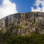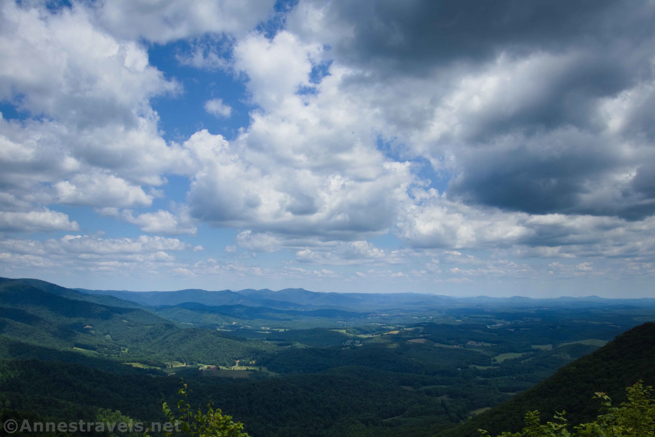

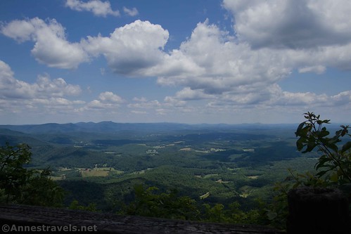
Last summer, I had the opportunity to drive up to the Blue Ridge Parkway with some dear relatives. On the way up, we stopped by a viewpoint called “Lover’s Leap.” Per me, the views here were better than what we saw from the Parkway, so I was very happy we stopped! The day was clear, which helped quite a bit… driving out a couple of days later, the haze had rolled in. But that day, the sun shone without too much haze for which the Blue Ridge is known.
Quick Stats

If you happen to be driving the Blue Ridge Parkway, you can take a side-trip down to Lover’s Leap. It’s only about 6 miles out of your way in each direction. Plus, you get to drive through the charming town of the Meadows of Dan (and if you hit it right, you can get a sandwich from the Poor Farmer’s Market – yum!)

There are two parts to the Lover’s Leap area. The first is just pulloffs along the side of the road. But I found this area to have the best views. The clouds were also gorgeous.

There was some graffiti on the stone walls, which was a shame. But it didn’t interfere with the views.

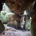
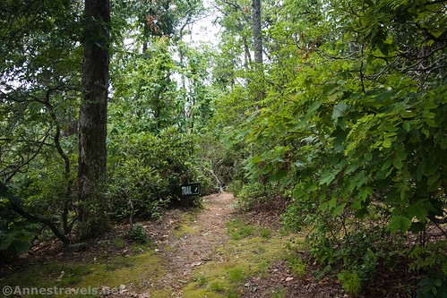
The second area is up a steep road with a sign for “Fred Clifton Park.” At the top of the road, there is a small parking area and some picnic tables. A trail leads up the hill a short distance to the first viewpoint.

There is also a second viewpoint. From here, the trail continues down to the main road (so I hear). You can see the main road from the second viewpoint.

As I said above, I felt that the views were better from the pullouts down below, but the viewpoints are still nice, and the ambiance is much better than along the road.
There were also some late-blooming rhododendrons in the woods near the viewpoints. They were quite pretty.

So overall, Lover’s Leap isn’t a very lengthy stop – but it’s well worth visiting if you happen to be in the area! The views rival those on the Blue Ridge Parkway and it’s not even a difficult hike!

Round Trip Length: Varies, but to both overlooks and back is 0.2 miles
Elevation Gain: 140ft. (2,846ft. to 2,944ft.) to both overlooks
Facilities: Picnic tables
Fees: None
Trail Notes: The area is open all year from what I can tell. Summer has classic clouds and green on the hills but can be hazy. Autumn colors are spectacular. In the winter, the trees are bare of leaves which makes the view less impressive. Spring often has fresh greenery, with blooming rhododendrons in the early summer.

Trail 
![]()
![]()
Road ![]()
Signs ![]()
Scenery ![]()
Would I go 100 miles out of my way for this? ![]()
Overall Rating: ![]()
GPS Coordinates for Lover’s Leap Viewpoint
First Pulloff: 36.71750568314118, -80.3220510135979 (36°43.05034′, -080°19.32306′ / 36°43’03.0205″, -080°19’19.3836″) (2,858ft.)
Second Pulloff: 36.717654726265174, -80.32321619901104 (36°43.05928′, -080°19.39297′ / 36°43’03.5570″, -080°19’23.5783″) (2,839ft.)
Trailhead: 36.719819000, -80.325418000 (36°43’11.4″, -080°19’31.5″ / 36°43’11.3484″, -080°19’31.5048″) (2,977ft.)
Overlook: 36.719752000, -80.325018000 (36°43.18512′, -080°19.50108′ / 36°43’11.1072″, -080°19’30.0648″) (2,995ft.) (150ft.)
Overlook 2: 36.719403000, -80.324817000 (36°43.16418′, -080°19.48902′ / 36°43’09.8508″, -080°19’29.3412″) (2,988ft.) (500ft.)

The gpx file for the Lover’s Leap Overlooks can be downloaded – please note that this and the GPS Coordinates are for reference only and should not be used as a sole resource when hiking this trail.
Download GPX File size: 2.0 KB Downloaded 467 times
(Note: I do my best to ensure that all downloads, the webpage, etc. are virus-free and accurate; however, I cannot be held responsible for any damage that might result, including but not limited to loss of data, damages to hardware, harm to users, from use of files, information, etc. from this website. Thanks!)
Getting to Lover’s Leap
From I-81, take I-77S toward Charlotte, NC. After about 17 miles, take Exit 14 toward US-58/US-221 and Hillsville/Galax. Keep left at the fork, following signs for Hillsville, and then turn left onto US-221N/US-58E/Carrollton Pike for 1.2 miles. Stay right to take the ramp onto US-52 (and US-58) toward Martinsville and Danville. Drive on US-58 for 27.9 miles. A sign for Fred Clifton Park is on the left – to access the overlooks, turn left up the steep road for 0.2 miles. To access the pulloffs, continue a short distance up US-58 to the pulloffs, on the left.

From Danville, take US-58 BUS W to where it merges with US-58W. Continue on US-58W for 14.5 miles; use the right lane to merge onto US-58/US-220 toward Stuart/Roanoke/Ridgeway/Greensboro. Drive on US-58W for another 9.3 miles, then take the exit toward US-58W toward Stuart. Merge onto US-58 BUS, and continue on US-58W 31 miles. On your right will be a couple of pulloffs – these are the ones with the good views. To access the overlooks, turn right by the sign for Fred Clifton Park and take the steep road up the hill 0.2 miles to the trailhead.

From the Blue Ridge Parkway, take the exit for the Meadows of Dan (approximately Milepost 177.7). Turn left onto US-58 BUS for 0.9 miles, then turn right on US-58E. The road up to the trailhead will be on the left after 5.5 miles – continue a short distance further to access the pulloffs, or turn left up the steep, 0.2 mile road up to the trailhead for the overlooks.

This Week’s Featured Product!
For trails along the Blue Ridge Parkway, there may be no better book in print. Beyond trail guides, the book also covers the history of the area and other attractions along the Parkway.