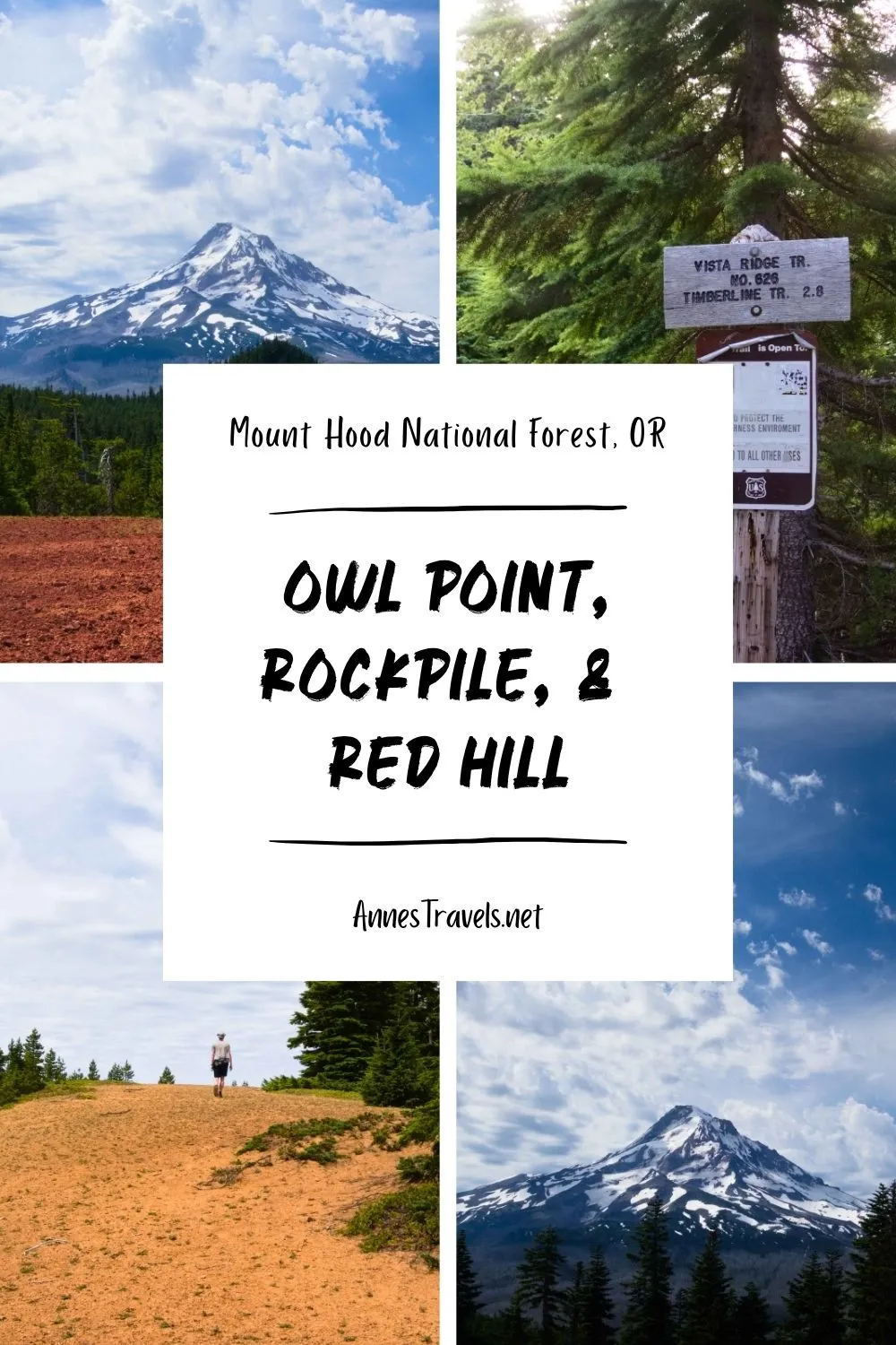

I’ve tried to hike Owl Point three times. And it was only on this last attempt that I succeeded! The first time, I turned the wrong direction and ended up on the Timberline Trail (oops!). The second time, I did make it to Owl Point, but the views of Mt. Hood were almost completely obscured by clouds. This time, though, was the charm! Not only did I get fantastic views from Owl Point, but I also went to the Rockpile and up Red Hill (which arguably has the best views of the three!) And the best part? While navigation can be a small challenge, the hike itself is short enough to do in half a day or less.
Quick Stats
The trailhead is a wooded area at the top of a dirt road. I didn’t have any trouble in my stock full-size van (high clearance but no 4×4), though you’d probably want to go slowly with low clearance and turn off the air conditioning (the road is steep!) It’s also many miles from civilization, so enjoy the peacefulness of the drive on a one-lane, two-way road – and be sure to download maps before you go, because cell service is less than limited up here!
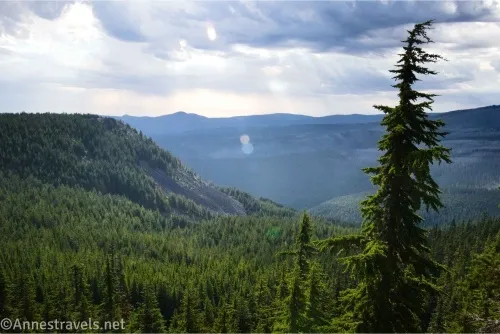
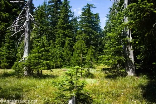
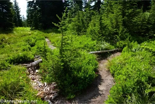
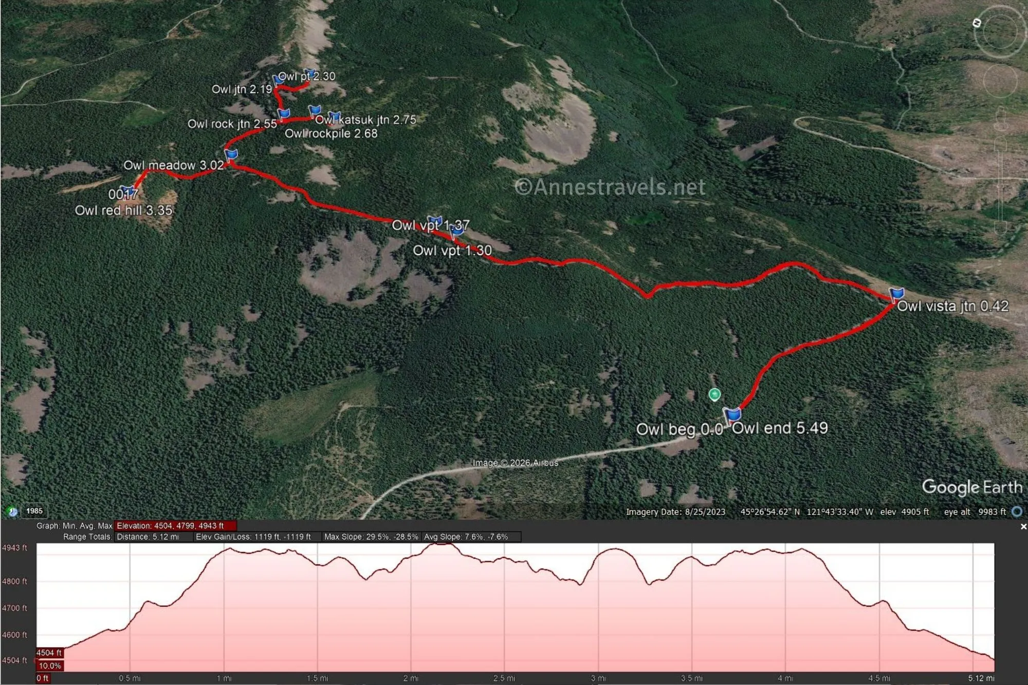
0.0 Vista Ridge TH (4,497ft.). The path is quite findable but also a little grown in (or at least narrow between the trees). It soon becomes a little wider as the hillside on the left moves away from the trail. Most of the trail along the way to all three viewpoints is forested, but there are occasional places to see down into the valleys around the ridgeline (which I’ll call out). (45.4428470°, -121.7291040°)
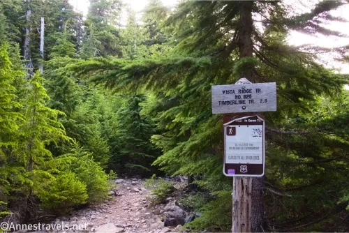
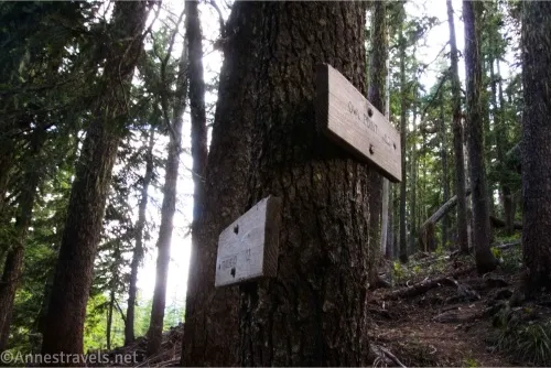
0.4 Vista Ridge Junction (4,624ft.). This is the tricky junction where I turned the wrong direction on my first visit. Thankfully, it’s better signed these days, with a fairly new sign that says, “Old Vista Ridge Trail No. 626A”. You want to turn left near the kiosk toward Owl Point (which is signed at 1.7 miles away). (45.4398450°, -121.7224290°)
1.3 Viewpoint 1 on the right (4,881ft.). This is not an official viewpoint; just a place you can get a view down into the valley. (45.4500890°, -121.7257090°)
1.4 Viewpoint 2 on the right (4,860ft.). Again, not an official viewpoint, though the view is better from here than from the first viewpoint. The next unmarked junction is for the Rockpile (45.4568470°, -121.7210760°), but I’ll save that for our trek back since that’s what I did. But if you’re looking for the Rockpile first, it’s an unmarked and possibly blocked-off path near signs on a tree (the tree is across the main path from the trail to the Rockpile) with signs for Owl Point and the Trailhead. (45.4507180°, -121.7255100°)
2.2 Owl Point Junction (4,908ft.). This junction is now marked (yay!) A trail leads down to the viewing area (which isn’t marked, but it’s not too hard to tell where to stop once you come out of the trees/meadows and onto some rocks). (45.4578690°, -121.7190390°)
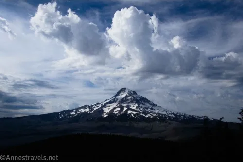
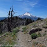
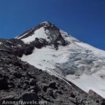
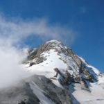
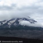
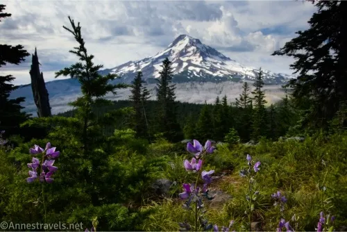
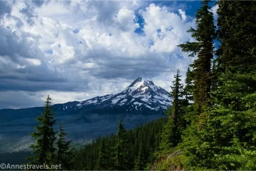
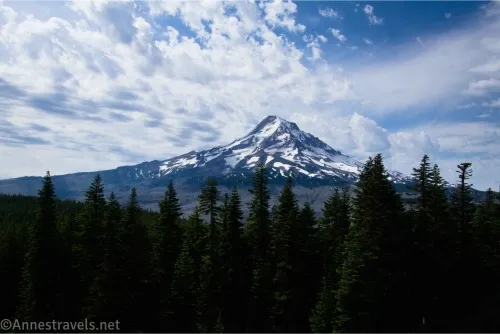
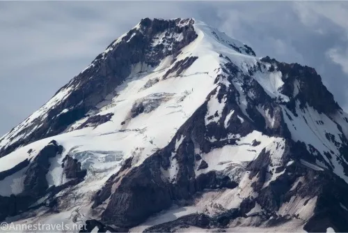
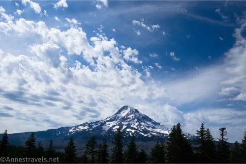
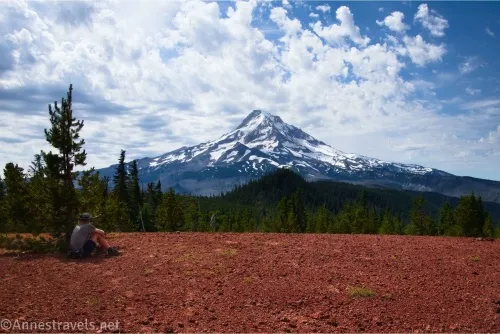
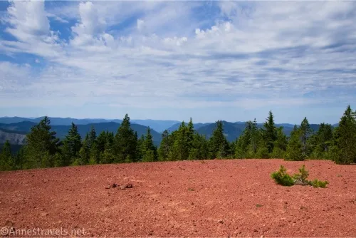
2.3 Owl Point (4,935ft.). Views are spectacular from here across the valley to Mount Hood. A wildfire took out a lot of trees in the area, which is a bit of a scar on the landscape, but it’s not too bad. As you can see in the pictures, I almost had a second cloudy day – but thankfully, the clouds weren’t hiding the mountain! You’re free to continue downhill down the rockslide, but I found the view was best from near the top. After we finished enjoying the view, we headed back to catch the Rockpile. (45.4571210°, -121.7182190°)
3.5 Rockpile Junction (4.859ft.). The junction is unmarked except for two signs on a tree opposite the lefthand turn (when coming back from Owl Point) – the signs point toward Owl Point and the Trailhead. The path may have sticks across it, but it’s a definite, worn trail that quickly exits the thick woods to travel through thinning woods/meadows. Along the way, you’ll pass the unmarked junction is for Katsuk Point, with the junction at 45.4560960°, -121.7204190° (which is also probably blocked off with a log or two). While you’re welcome to go to Katsuk Point, I found the views to be even less inspiring than from the Rockpile – but it does give you more privacy than either the Rockpile or Owl Point. (45.4568470°, -121.7210760°)
2.7 The Rockpile (4,887ft.). While I didn’t find the views from the Rockpile to be quite as good as the ones from Owl Point, it’s still a very nice overlook. After admiring the view, return to the main path, turn left (toward the traihead), and keep your eyes open for a place where the trail passes through a small meadow. (45.4553700°, -121.7206270°)
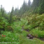
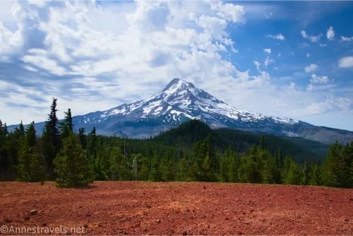
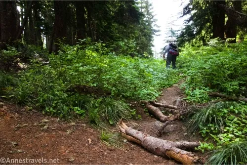
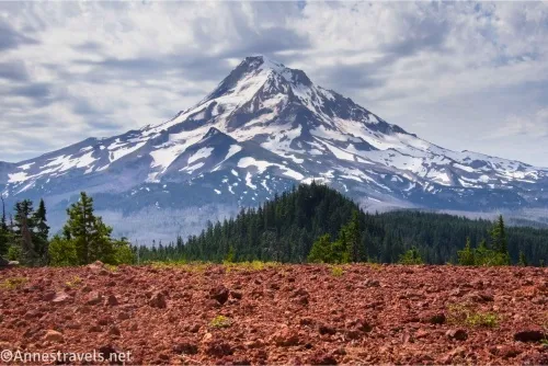
3.0 Meadow/Turnoff for Red Hill (4,802ft.). There isn’t much of a trail leaving the main trail here, though you may find a light path through the meadow, which ends as soon as you come to the woods. Beyond this, there is only the vaguest of trails. Someone had tied ribbons to trees most of the way when I visited in the summer of 2024, but the best idea is to keep heading generally uphill in a direction that seems right (not that helpful, I know, but that’s exactly what I did, and it worked out!) The route heads a bit to the right through the forest, then begins up a hillside, shying left. As you climb higher, you’ll find the trees thinning and that you’re walking on tan, then brownish-yellow dirt. Just before reaching the summit, the dirt/gravel under your feet turns red. (45.4572790°, -121.7240290°)
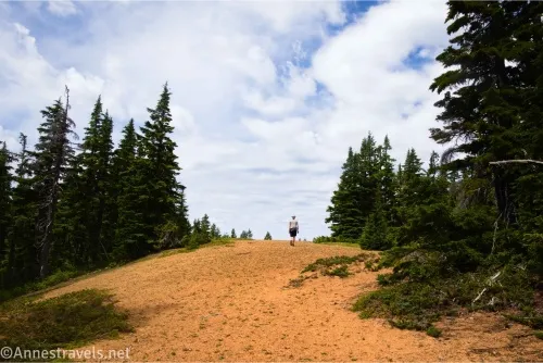
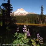
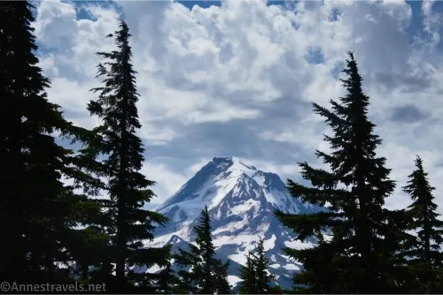
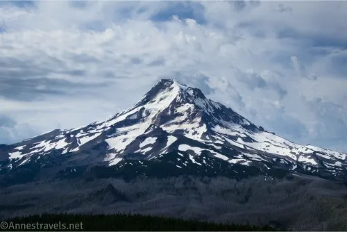
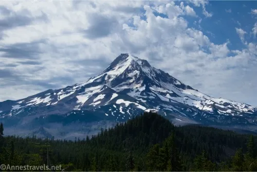
3.4 Red Hill (4,921ft.). Owl Point gives a better overall view of Mt. Hood, but I love the views from Red Hill, probably because of all the colors: The mountain is gray and white, the sky is blue, the trees are freshly green, and the hill is red. It’s unique, for sure! My biggest complaint was that there was nowhere to sit down to enjoy said view – but we did our best, anyway, before retracing our steps to the main path and from there to the parking area. (45.4585140°, -121.7278140°)
5.5 Vista Ridge TH (4.503ft.). (45.4428750°, -121.7290790°)
Round Trip Trail Length: Doing all three viewpoints, I went a total of 5.5 miles. Out & back to Owl Point would be 4.6 miles, out & back to the Rockpile would be about 4.2 miles, and out & back to Red Hill would be 4.3 miles.
Elevation Gain: 1,119ft. (4,505ft. to 4,943ft.)
Facilities: None (not even a restroom)
Fees: $5/day Northwest Forest Pass required for each vehicle. America the Beautiful National Parks & Federal Public Lands Passes and Northwest Forest Annual Passes are accepted.
Trail Notes: The Old Vista Trail is not an official route – it’s an old trail kept up by volunteers. Make their lives easy by keeping it clean, and be grateful for all of the work someone has done to clear downed trees off the path! Both Owl Point and the Rockpile are made up of piles of rocks, so use care when scrambling around. The views to Mt. Hood are a little more distant than, say, Paradise Park, Gnarl Ridge, McNeil Point, or Cooper Spur, but not as far away as Lookout Mountain. Funny story: On our way up to Owl Point trailhead the second time, we suddenly found cell signal along of the dirt roads. So we stopped the van, turned off the engine, and took care of all the phone calls that were on our list (including trying to work out a double charge on the credit card and renewing library books… were they surprised to hear we were calling from the other side of the continent!) before continuing up to the trailhead!
Trail 
![]()
![]()
![]()
Road ![]()
![]()
Signs ![]()
![]()
Scenery
Would I go 100 miles out of my way for this?
Overall Rating: 
![]()
Owl Point, The Rockpile, and Red Hill GPS Coordinates
Vista Ridge TH: 45.4428470°, -121.7291040° (45°26.57082′, -121°43.74624′ / 45°26’34.2492″, -121°43’44.7744″) (4,497ft.) (0.0)
Vista Ridge Junction: 45.4398450°, -121.7224290° (45°26.39070′, -121°43.34574′ / 45°26’23.4420″, -121°43’20.7444″) (4,624ft.) (0.42)
Viewpoint 1: 45.4500890°, -121.7257090° (45°27.00534′, -121°43.54254′ / 45°27’00.3204″, -121°43’32.5524″) (4,881ft.) (1.30)
Viewpoint 2: 45.4507180°, -121.7255100° (45°27.04308′, -121°43.53060′ / 45°27’02.5848″, -121°43’31.8360″) (4,860ft.) (1.37)
Owl Point Junction: 45.4578690°, -121.7190390° (45°27.47214′, -121°43.14234′ / 45°27’28.3284″, -121°43’08.5404″) (4,908ft.) (2.19)
Owl Point: 45.4571210°, -121.7182190° (45°27.42726′, -121°43.09314′ / 45°27’25.6356″, -121°43’05.5884″) (4,935ft.) (2.30)
Rockpile Junction: 45.4568470°, -121.7210760° (45°27.41082′, -121°43.26456′ / 45°27’24.6492″, -121°43’15.8736″) (4,859ft.) (2.55)
The Rockpile: 45.4553700°, -121.7206270° (45°27.32220′, -121°43.23762′ / 45°27’19.3320″, -121°43’14.2572″) (4,887ft.) (2.68)
Katsuk Point Junction: 45.4560960°, -121.7204190° (45°27.36576′, -121°43.22514′ / 45°27’21.9456″, -121°43’13.5084″) (4,882ft.) (2.75)
Meadow (turnoff for Red Hill): 45.4572790°, -121.7240290° (45°27.43674′, -121°43.44174′ / 45°27’26.2044″, -121°43’26.5044″) (4,802ft.) (3.02)
Red Hill: 45.4585140°, -121.7278140° (45°27.51084′, -121°43.66884′ / 45°27’30.6504″, -121°43’40.1304″) (4,921ft.) (3.35)
End: 45.4428750°, -121.7290790° (45°26.57250′, -121°43.74474′ / 45°26’34.3500″, -121°43’44.6844″) (4,503ft.) (5.49)
The gpx file for Owl Point, the Rockpile, and Red Hill can be downloaded – please note that this and the GPS Coordinates are for reference only and should not be used as a sole resource when hiking this trail.
Download GPX File size: 63.7 KB Downloaded 188 times
(Note: I do my best to ensure that all downloads, the webpage, etc. are virus-free and accurate; however, I cannot be held responsible for any damage that might result, including but not limited to loss of data, damages to hardware, harm to users, from use of files, information, etc. from this website. Thanks!)
Getting to the Owl Point, Rockpile, and Red Hill Trailhead
The easiest way to get to the trailhead is to follow a reliable GPS with pre-downloaded maps – as I recall, we used GoogleMaps, but I might have pulled out my old Garmin car GPS (the one that likes to crash at the most inopportune moments… and at this point, it crashes every 30 seconds or so). I was half-asleep after hiking close to a dozen miles in the heat, but trying to navigate, so maybe that’s why I don’t remember.
From I-84, take Exit 62 to Hood River. Turn right onto Westcliff Drive, then make an immediate right onto Country Club Road. The road will parallel I-84 for a short distance, then turn south. At the T, turn left onto Barret Drive for about 1 mile; turn right onto Tucker Road (there will be a gas station and grocery store at this junction). Tucker Road crosses a bridge and passes a fruit market; soon afterward, turn right onto Dee Highway for 7 miles to an abandoned mill site in Dee. Take the right fork onto Lost Lake Highway and follow the signs for Lost Lake. At crossroads, be sure to stay on Lost Lake Highway; you may have to turn a few times to stay on the right road. The road will change names to Forest Road 13 when it enters the national forest. When Lolo Pass Road turns left about 11 miles from Dee, follow it, turning left off of Lost Lake Highway. After 3.2 miles, turn left at the fork to ascend, following the signs for the Vista Ridge Trailhead. Follow the switchbacks upward; 0.8 miles later, stay left on NF-16 for 4.6 miles, then take a sharp right up NF-1650 3.2 miles to the trailhead. It’s a little over 30 miles from Hood River to the trailhead, but you won’t be able to go fast on a number of those miles – the road is paved until NF-16, but it’s nearly one lane in many places and the crazy curves will keep your speed down. Plan an hour or more travel time.
Alternatively, if you’re coming from the south, from OR-35 in the town of Mt. Hood, turn onto Cooper Spur Road (OR-281) next to the Mt. Hood Country Store. Drive 1.8 miles; turn right to stay on OR-281N for another 5.8 miles. Take a sharp left onto Lost Lake Road near the old sawmill in Dee. Follow the directions (above) to the trailhead.
More Hikes around Mount Hood
With 85 hikes, this is one of the best trail guides to hiking around Mount Hood. Buy your copy here.