

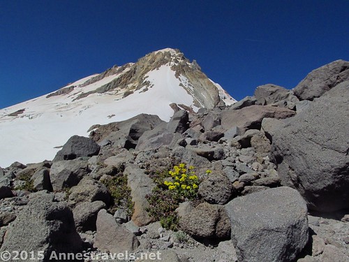
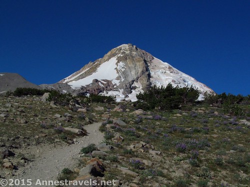
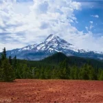
Sometimes we just have to do a hike twice. It’s just that epic; that worth redoing that we’ll drive 100 miles out of our way just to do a single hike again. Such is Cooper Spur, high on the side of Mt. Hood, spectacularly showcasing the Elliot Glacier, Mt. St. Helens, Mt. Adams, Mt. Rainier, Mt. Jefferson, and the lowlands surrounding the Columbia River. The trail itself has views most of the way up, leading to one of the highest dayhiker-accessible points on Mt. Hood. And at not quite 8 miles round trip, well, wouldn’t you want to hike it?
Quick Stats
(Affiliate links are present on this page.)
As I said above, we’d hiked the Cooper Spur Trail once before, on our way from Great Basin and Yosemite up to the Olympic Area where we planned to meet up with friends for a few days. That time, much of the view below us and to the north had been obscured by clouds, creating a kind of surreal, walking-on-air experience. This time, though, the clouds held off, and we had great weather the whole way!
Unbeknown to us, the road up to the parking area had been closed until the day before our arrival. So we chugged right up the gravel road, through the burned out trees that had made the road unsafe only days before, and were met by an overflowing parking area! I think all of Portland was enjoying the fact that the Cloud Cap Inn and area trails were again open to the public…even the missing door on the outhouse didn’t stop the people from hiking, picnicking, exploring, camping, etc., etc., etc.
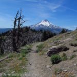
We started out early the next morning after some of my group members had scrambled up above the campground to take in the sunrise on Mt. Hood (I did it the next morning). The trail (which begins in the picnic / camping area) splits almost immediately; follow the Timberline Trail straight ahead. After this, the trail climbed steadily through the trees for another 0.1 miles to the Gnarl Ridge / Elk Park Junction; continue left toward Gnarl Ridge.
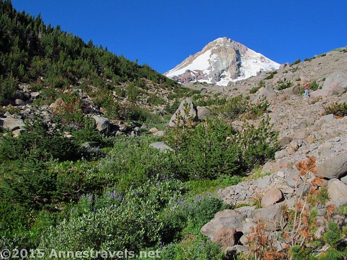
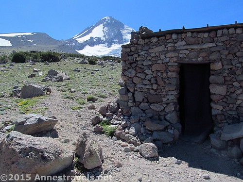
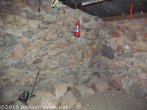
After this, the trail began to break out of the trees and pass through rockfields as it works its way upward for another 1.1 miles to the Cooper Spur Trail / Tilly Jane Trail Junction, nearly above the treeline. Turn right here through rocks and almost tundra landscape. A quarter mile later, either continue upward or take a short side trail to visit the CCC Warming Hut.
We figured the campers nearby wouldn’t appreciate a hoard of dayhikers stomping through before 8am (11am Eastern Time!), so we visited on the way back down several hours later.
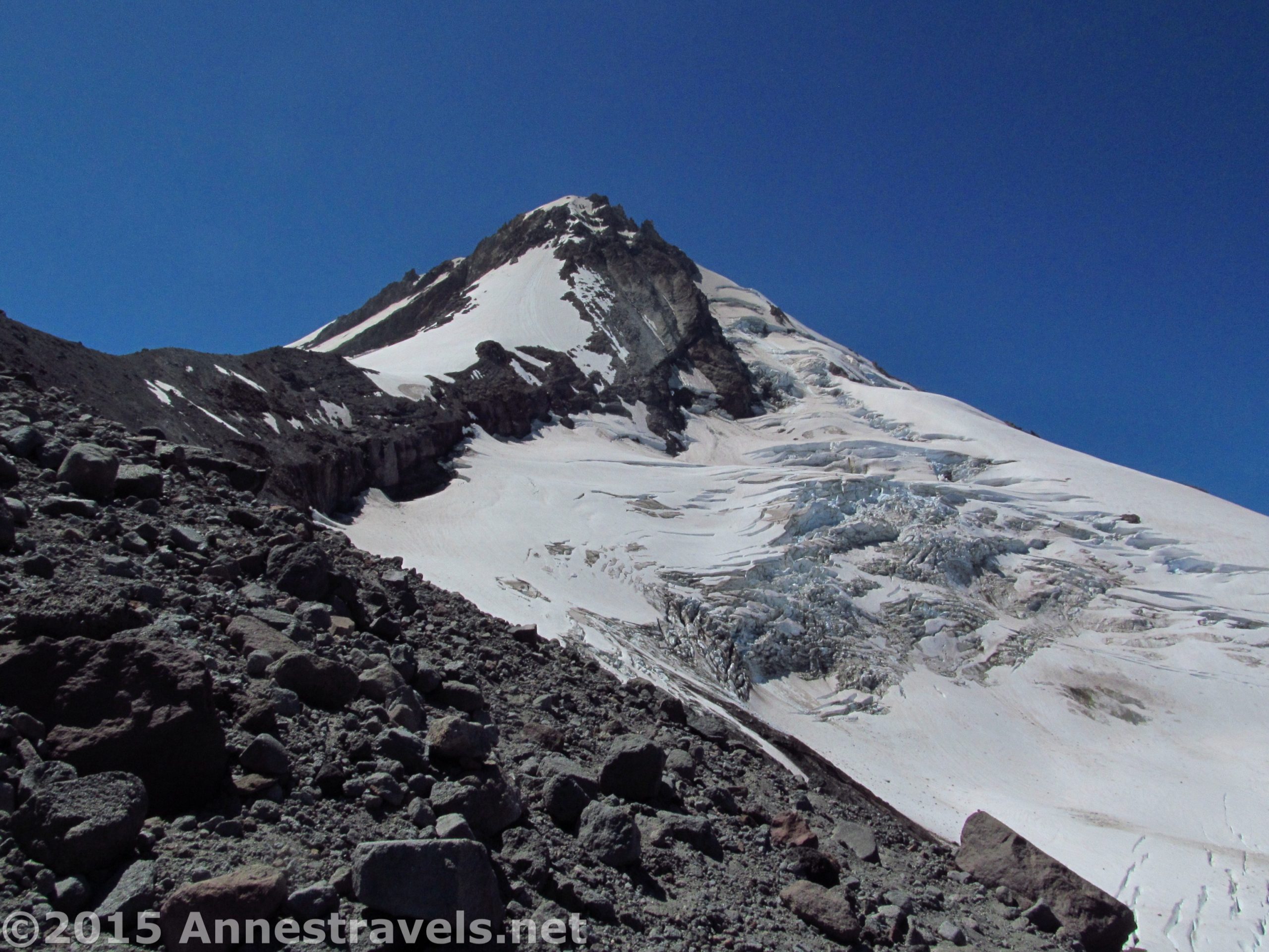
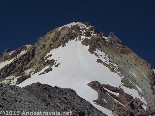
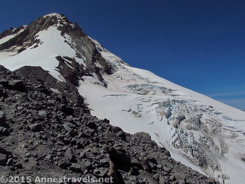
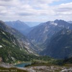
The trail keeps winding upward in switchbacks. At the ends of the switchbacks, it’s quite common to come across social trails that take off across the rocks along the edge of the ridge that separates Cooper Spur from the Elliot Glacier. We took one of these trails, and if you really like views of glaciers (and don’t mind a bit of scree travel), I highly recommend you do the same. For a little over half a mile, the social trail is fairly easy to follow and not too difficult to traverse, so it makes for a nice alternative to the views from the trail.
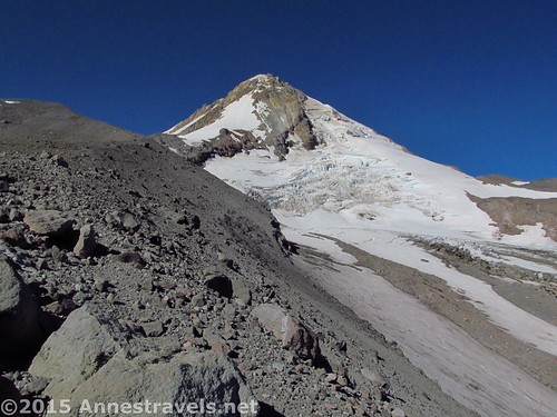
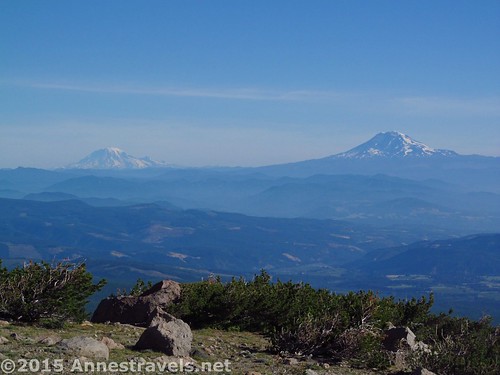
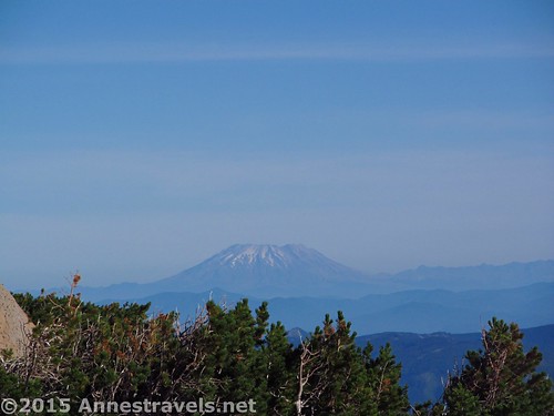
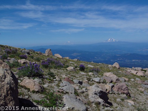
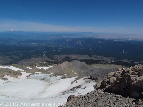
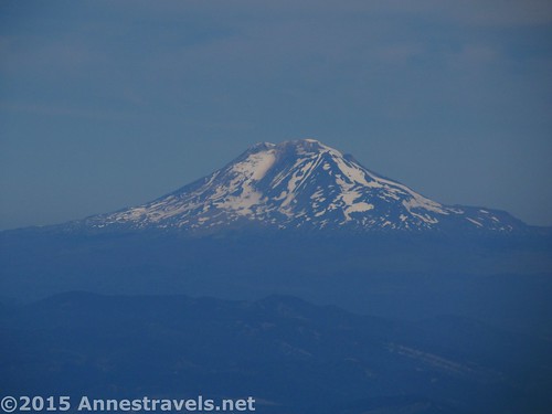
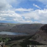
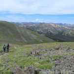
The views from the trail are mostly overlooking the farmlands around the Columbia River and the major volcanic peaks to the north: Mt. Adams, Mt. St. Helens (notice the flat top?), and Mt. Rainier. Of course, these are also visible from the social trail, along with glacier views. Wow!
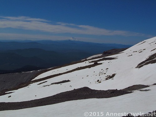
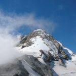
After we regained the trail at 2.1 miles, the trail relentlessly continues to switchback up the ridge. It finally comes around the other side of the ridge, with views south toward Mt. Jefferson. Here in early August we came to several snowfields. They weren’t terribly dangerous, since a trail had been packed across them, but they took some care to cross. I guess that’s what we get for August over October!
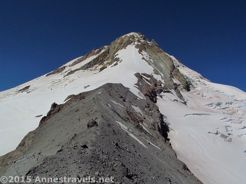
Finally, 3.5 miles from the parking area, we gained the top of the trail at a monument and a small rock creation (meant as a wind block). Some of my group stayed here, while the rest of us scrambled up the ridge another half mile to the snowline…about the same place as in October. Cool!
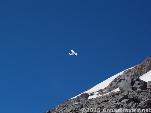
But more cool was to come. As we stood there at the very top, taking pictures, a little yellow airplane started dive-bombing us. Really, I think it was going after the glacier, but it got a lot closer to us than I was really happy about! Then it dipped down along the glacier – I don’t think I’ve ever watched a plane fly below me before – at least not with my feet on solid ground – and swooped upward again to pass through a narrow rock formation above the glacier! Talk about entertainment!
Return by the way you came, or (like we did) stick to the trail instead of the social trails along the crest of the glacial valley.
We got back to the parking area to find the concessionaire who runs the campground busily resetting up the fee station, signs, even promising us that the door on the outhouse would soon be repaired. But for that night, he assured us, we could stay for free!
Round Trip Trail Length: 7.9 miles
Lowest Elevation (Trailhead): 5,839 ft.
Highest Elevation (End at top of trail): 8,929 ft.
Net Elevation Change: 3,090 ft.
Facilities: Primitive restroom, picnic tables, historic (though not open) inn, campground
Special considerations: The campground is $10/night; tents only. Sunrise is beautiful over Mt. Hood.
Fees: $5/day to park. Alternatively, America the Beautiful (Interagency), Senior (Golden Age), Access (Golden Access), Volunteer, Military, and Northwest Forest Service Annual Passes can be displayed in the windshield of your vehicle.
Trail 
![]()
![]()
Road ![]()
![]()
Signs ![]()
Scenery
Would I go 100 miles out of my way for this?
Overall Rating: ![]()
Key GPS Coordiantes
Cloud Cap Parking: 45.40240N / -121.65494W (45° 24′ 8.64″ / -121° 39′ 17.7834″) (5,743ft.)
Trail Beginning: 45.40236N / -121.65482W (45° 24′ 8.496″ / -121° 39′ 17.352″) (5,839ft.) (ended 7.93)
Tilly Jane / Timberline Trail Junction: 45.40193N / -121.65522W (45° 24′ 6.948″ / -121° 39′ 18.7914″) (5,855ft.) (150 ft.)
Gnarl Ridge / Elk Park Junction: 45.40083N / -121.65565W (45° 24′ 2.9874″ / -121° 39′ 20.3394″) (5,934ft.) (0.14)
Cooper Spur Trail / Tilly Jane Trail Junction: 45.38977N / -121.65907W (45° 23′ 23.1714″ / -121° 39′ 32.6514″) (6,633ft.) (1.25)
CCC Warming Hut: 45.38869N / -121.66078W (45° 23′ 19.2834″ / -121° 39′ 38.808″) (6,810ft.) (6.60 on the way back)
Left main trail for the edge: 45.38645N / -121.66441W (45° 23′ 11.22″ / -121° 39′ 51.876″ (7,030ft.) (1.66)
Returned to the main trail: 45.38309N / -121.66846W (45° 22′ 59.124″ / -121° 40′ 6.4554″) (7,426ft.) (2.09)
“Top” of trail: 45.37680N / -121.67513W (45° 22′ 36.48″ / -121° 40′ 30.4674″) (8,461ft.) (3.50)
End (Top) of the Trail: 45.37510N / -121.68258W (45° 22′ 30.36″ / -121° 40′ 57.288″) (8,929ft.) (4.0)
The gpx file for Cooper Spur can be downloaded – please note that this and the GPS Coordinates are for reference only and should not be used as a sole resource when hiking this trail.
Download GPX File size: 228.5 KB Downloaded 496 times
(Note: I do my best to ensure that all downloads, the webpage, etc. are virus-free and accurate; however, I cannot be held responsible for any damage that might result, including but not limited to loss of data, damages to hardware, harm to users, from use of files, information, etc. from this website. Thanks!)
Getting to the Cooper Spur (Cloud Cap) Trailhead
From Hood River, OR (Exit 64 from I-84), take US-30W south for almost 0.5 miles; continue straight onto OR-35S for 22.2 miles. Turn right onto Cooper Spur Road. (Alternatively, from Government Camp, take US-26E 2.6 miles; turn left onto OR-35N for 16.6 miles and turn left onto Cooper Spur Road.) After 2.4 miles, turn left onto the Cloud Cap Road for 1 mile; stay right to continue on Cloud Cap Road. After 1.7 miles, turn left to stay on Cloud Cap Road for an additional 7 miles. Turn right again to stay on Cloud Cap Road for 0.6 miles to the trailhead at (nearly) the end of the road. (Beware of washboard and 20-some extremely rough water troughs – don’t take this road too fast!)
Zoom map out to browse nearby hikes & places of interest

This Week’s Featured Product!
Looking for more hikes in the northern Oregon / southern Washington area? This book covers 60 trails, all within 60 miles of Portland, OR, including hikes on the coast, in the Columbia River Gorge and Willamette Valley, around Mt. Hood and Mt. St. Helens, and near the Santiam and Clackamus Rivers.
More Related Posts:
 Some of the Best Views in the Cascades from Sahale Arm
 Cooper Spur: Highest Trail on Mt. Hood
 Flat Tops to Himes Peak: Adventurous, but Beautiful
 The Chapin / Chiquita / Ypsilon Loop: 3 Summits, 8 Miles!
 Lookout Mountain – Fabulous Views of Mt. Hood!
 Owl Point, the Rockpile, and Red Hill – third time’s the charm!
2 responses to “Cooper Spur: Snow, Ice, and Rocks”
[…] clouds lift from Mt. Hood and Cooper Reach along the Cooper Spur Trail, […]
[…] 3. Cooper Spur, Mt. Hood National Forest, Oregon. This hike has long been an outstanding favorite. Mt. Hood, glaciers, and the Columbia River Valley make this one stand out as memorable. […]