
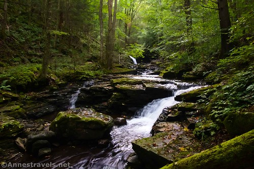
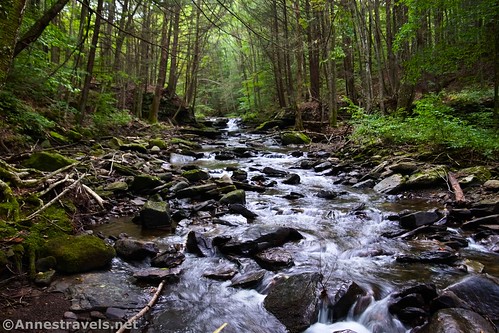
Double Run came to me as a totally delightful and unexpected surprise. I was looking for a short hike in World End State Park after hiking the Canyon Vista & Cold Run Loop, so I took off on the “nature trail” – not because I really wanted to, but because the map said there might be a waterfall along the way. What they didn’t bother mentioning was that the path has more than 8 waterfalls, each about a tenth of a mile apart – in only 1.25 mostly flat miles! Talk about a gem of a hike!
Quick Stats
Double Run is actually a loop hike, but the second half of the loop just isn’t worth hiking in my opinion (more on that later). Of course, the waterfalls are best after a rain, but I gather the creek flows all year.
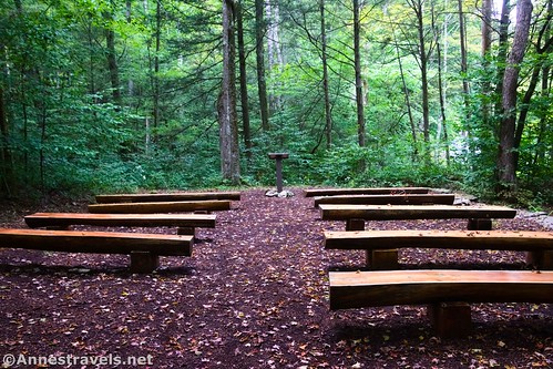
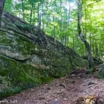
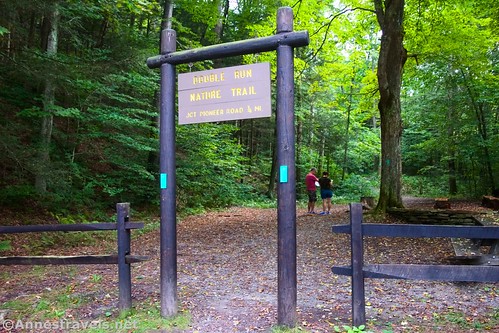
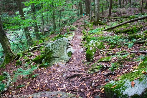
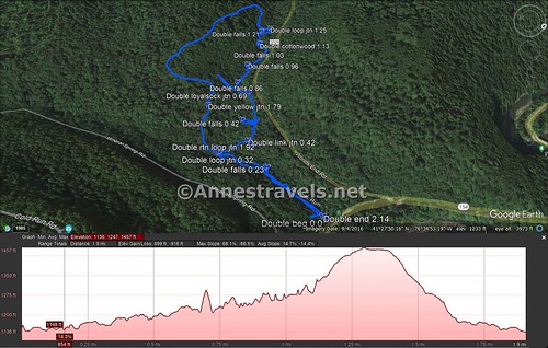
The Double Run Trailhead is well-marked. The path heads into the trees, (usually) marked by green plastic blazes, passing by the rustic amphitheater. It follows the creek and arrives at the first small waterfall (maybe we’ll call it First Falls) at mile 0.25.
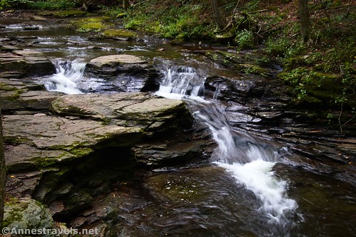
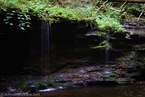
The path continues to cross a fork of Double Run just before the loop option goes off on the left at mile 0.3. Turn right to cross over Double Run (the paths may get a little hard to follow in this section; keep looking for the green plastic blazes). Even here, there are multiple small waterfalls.
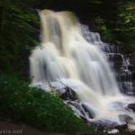
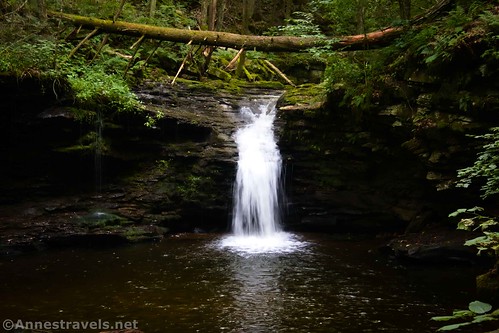
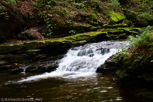
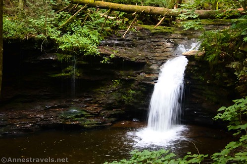
About a tenth of a mile after the loop junction, the Link Trail goes off on the right. Be careful to turn left here – it’s not necessarily a logical turn! A short distance (less than a tenth of a mile) beyond this is another great waterfall, which I’ll christen Darth Vader Falls (if you see it, you’ll understand).
Darth Vader Falls is also pretty from the side.

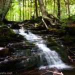
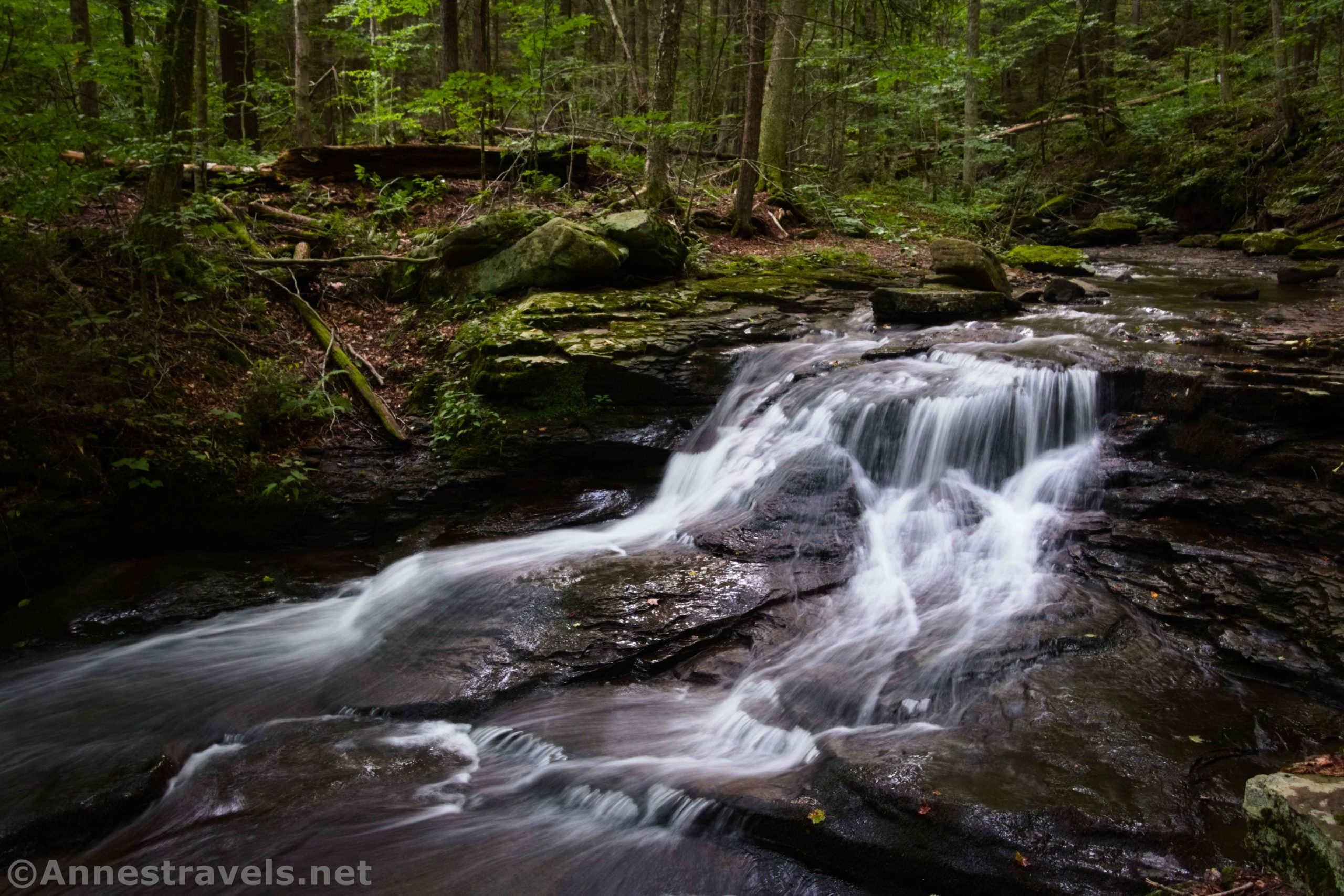
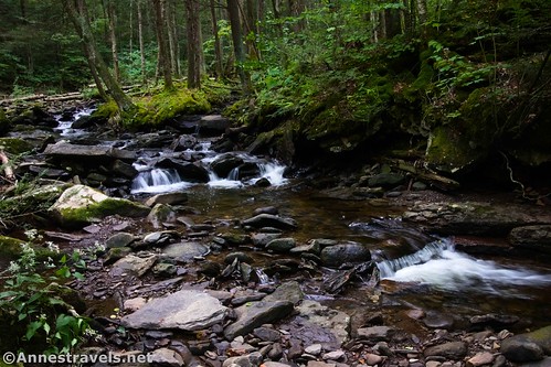
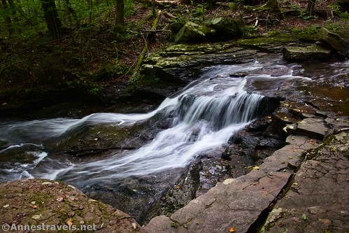
Keep hiking upstream. The Loyalsock Trail takes a sharp right turn at mile 0.7; stay left along Double Run. Another unnamed falls (shall we call it Small Drop Falls?) is found at mile 0.8…

And another unnamed falls a tenth of a mile later (we’ll call this one Lacy Cascade)…
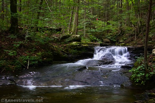
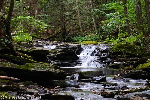
And yet another unnamed falls (we’ll call it Double Falls) a tenth of a mile beyond this one.
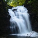
At mile 1.1, you’ll come to the first and only named waterfall on the entire Double Run Trail. Cottonwood Falls is 10ft. high and is located just above a bowl-like area of the creek.
If you look over to the left after a heavy rain, you may see small trickles of water falling into the bowl.
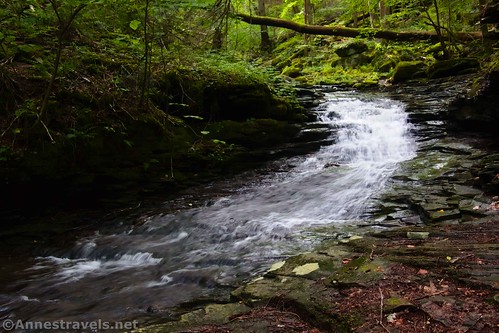
One final unnamed falls (Spillway Falls, because it reminds me of waterfalls created by dam spillways) is a tenth of a mile upstream of Cottonwood Falls.

Just upstream of this final waterfall, the trail splits. The Double Run Trail continues straight upstream, while the loop portion of the hike turns left to cross a bridge. What I should have done was to continue up Double Run to where it meets Worlds End Road. However, I didn’t know any better, so I happily crossed the bridge and headed up the path.

Up is about right! The trail steeply climbs up and over the hill, then steeply descends down the other side. And what do you get for all of this hard work? Little more than a workout. No views, no more waterfalls, just a lot of muscle work!
But if you decide to complete it as a loop, the trail junctions with the East Branch Trail (yellow blazes) at mile 1.8; continue left to return to the loop junction near the two branches of Double Run at mile 1.9.
From here, cross over the alternate branch of the creek and follow the trail back to the parking area.
Round Trip Trail Length: 2.1 miles (or thereabouts)
Elevation Gain: 916ft. elevation gain (1,136ft. to 1,457ft.)
Facilities: None
Fees: None
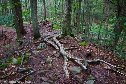
Trail Notes: I’ve heard that people do swim in the creek. When I came back, a family was trying to slide down the first waterfall, and it wasn’t working at all (besides being extremely cold, the rocks weren’t slippery). The waterfalls will be best after a rain, though I hear the creek (and the falls) are fairly full year-round. While most of the trail along the creek doesn’t have a ton of elevation gain, the path is rugged; you’ll want to wear sturdy shoes.

Trail 
![]()
![]()
Road ![]()
Signs ![]()
![]()
Scenery ![]()
![]()
Would I go 100 miles out of my way for this? ![]()
Overall Rating: 
![]()

GPS Coordinates for Double Run
Trailhead: 41.4658000°, -076.5786130° (41°27.94800′, -076°34.71678′ / 41°27’56.8800″, -076°34’43.0068″) (1,136ft.) (0.0)
Falls: 41.4642830°, -076.5796500° (41°27.85698′, -076°34.77900′ / 41°27’51.4188″, -076°34’46.7400″) (1,155ft.) (0.23)
Loop Junction: 41.4631770°, -076.5796190° (41°27.79062′, -076°34.77714′ / 41°27’47.4372″, -076°34’46.6284″) (1,175ft.) (0.32)
Link Trail Junction: 41.4636380°, -076.5803000° (41°27.81828′, -076°34.81800′ / 41°27’49.0968″, -076°34’49.0800″) (0.42)
Falls: 41.4632540°, -076.5810490° (41°27.79524′, -076°34.86294′ / 41°27’47.7144″, -076°34’51.7764″) (1,192ft.) (0.52?)
Loyalsock Trail Junction: 41.4631040°, -076.5821210° (41°27.78624′, -076°34.92726′ / 41°27’47.1744″, -076°34’55.6356″) (1,242ft.) (0.69)
Falls: 41.4626710°, -076.5824870° (41°27.76026′, -076°34.94922′ / 41°27’45.6156″, -076°34’56.9532″) (1,238ft.) (0.86)
Falls: 41.4626340°, -076.5834630° (41°27.75804′, -076°35.00778′ / 41°27’45.4824″, -076°35’00.4668″) (1,259ft.) (0.96)
Falls: 41.4628130°, -076.5840080° (41°27.76878′, -076°35.04048′ / 41°27’46.1268″, -076°35’02.4288″) (1,284ft.) (1.03)
Cottonwood Falls: 41.4626020°, -076.5846690° (41°27.75612′, -076°35.08014′ / 41°27’45.3672″, -076°35’04.8084″) (1,282ft.) (1.13)
Falls: 41.4624700°, -076.5853100° (41°27.74820′, -076°35.11860′ / 41°27’44.8920″, -076°35’07.1160″) (1,302ft.) (1.21)
Loop Junction: 41.4626870°, -076.5854360° (41°27.76122′, -076°35.12616′ / 41°27’45.6732″, -076°35’07.5696″) (1,325ft.) (1.25)
Yellow Trail Junction: 41.4624150°, -076.5810200° (41°27.74490′, -076°34.86120′ / 41°27’44.6940″, -076°34’51.6720″) (1,243ft.) (1.79)
Return to the loop junction: 41.4630350°, -076.5797370° (41°27.78210′, -076°34.78422′ / 41°27’46.9260″, -076°34’47.0532″) (1,172ft.) (1.92)
End: 41.4657400°, -076.5786590° (41°27.94440′, -076°34.71954′ / 41°27’56.6640″, -076°34’43.1724″) (1,138ft.) (2.14)
The gpx file for Double Run Loop can be downloaded – please note that this and the GPS Coordinates are for reference only and should not be used as a sole resource when hiking this trail.
Download GPX File size: 35.9 KB Downloaded 368 times
(Note: I do my best to ensure that all downloads, the webpage, etc. are virus-free and accurate; however, I cannot be held responsible for any damage that might result, including but not limited to loss of data, damages to hardware, harm to users, from use of files, information, etc. from this website. Thanks!)

Getting to the Double Run Trailhead
If traveling from the east on I-80 (so traveling I-80W), take Exit 232 onto PA-42N. Drive 10.4 miles; turn right to stay on PA-42N. After 7.9 miles, turn left onto PA-118W for 0.3 miles. Turn right onto PA-42N. After 7.4 miles, turn right onto US-220N. Drive 1.1 miles and then turn left onto PA-42N for 4.4 miles. Turn left onto Worlds End Road for 5.7 miles; turn right onto PA-154E. The Canyon Vista Trailhead will be on your left 2.3 miles later.
If traveling from the west on I-80 (so traveling I-80E), take Exit 212B onto I-180W. After 12.4 miles, take Exit 13 for PA-405 toward Muncy/Hughesville; turn right onto PA-405N for 0.3 miles. Stay on PA-405N (Water Street) by turning slightly right and then slightly right again. Use the left lanes to turn left to stay on PA-405N for another 3.2 miles. Continue straight onto US-220N for 13.1 miles. Turn left onto PA-42N for 4.4 miles, then turn left onto Worlds End Road for 5.7 miles. The Canyon Vista Trailhead will be on your left 2.3 miles later.
Today’s Featured Product!
Search out (or stroll to) over 180 waterfalls in Pennsylvania with this guide. With so many beautiful falls to choose from, you will discover delightful places on every hike! Buy your copy here.