
If you’re looking for a nice, long hike in northern Pennsylvania, I highly recommend the Canyon Run Trail in World’s End State Park (with the added loop of the Cold Run Trail). It’s mostly a forested hike with a few nice viewpoints, a peaceful stroll along the river, a climb up along a seasonal stream, a few seasonal (but very pretty) waterfalls, and some giant rocks. The park even has free entry!
Quick Stats
(This post contains affiliate links – there is no extra cost to you, but I may receive a small commission if you click and link and buy something.)

There are several places where you could begin your hike. If you’re staying at the campground, you might as well park there, since the loop goes right by the campground entrance. We opted to start up at Loyalsock Canyon Vista, parking right across the road from the Rock Garden (another fun little diversion). This was the most beautiful place to begin; however, I’d recommend starting next to the Canyon Vista Trail sign down by the river. Not only is there ample parking down there, but you’ll also get the climbing part of the hike out of the way first, leaving the easy stroll along the river for last.
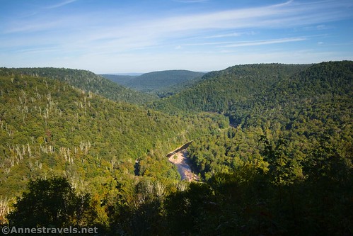
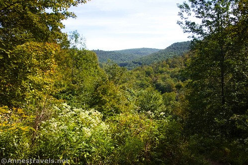
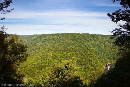
But since we didn’t do that, we started our hike up at Loyalsock Canyon Vista. The views from here are well worth driving to even if you’re not planning to hike the trail.

A set of stairs led us down to the viewpoint. From there, you can move along the railing in both directions for slightly different views.
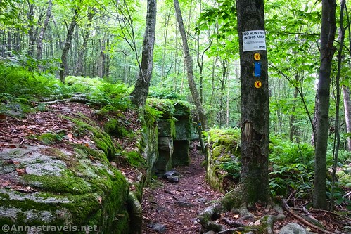
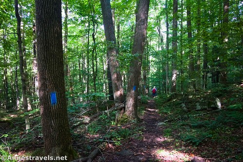
We then turned left (west and south) to follow the trail into the forest (follow the blue blazes – the Canyon Vista Trail is blazed with blue). The trail begins traveling downhill and arrives at the junction for Ticklish Rock after almost 0.4 miles. This is a worthy, short sidetrack to a balancing rock.

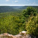
Continuing down the main trail, turn right at the junction with the Link Trail about mile 0.6. The trail continues downhill another 0.2 miles to a vista. While it’s slightly grown in, there’s more of a view than on much of the rest of the trail.

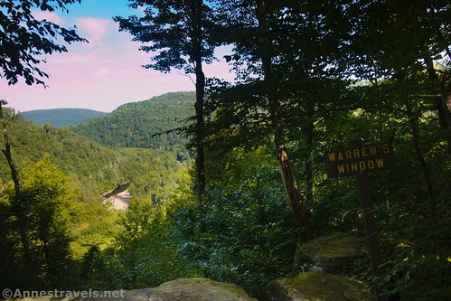
About 0.3 miles beyond the vista, you’ll come to a second viewpoint known as Warren’s Window (so sayeth the sign). It’s named after Warren Renninger, a park volunteer to built and maintained many trails in World’s End State Park, including the Cold Run Trail (which you’ll be seeing later). He has backpacked more than 15,000 miles through the wilderness, including walking from Florida to Newfoundland in 2011/2012.
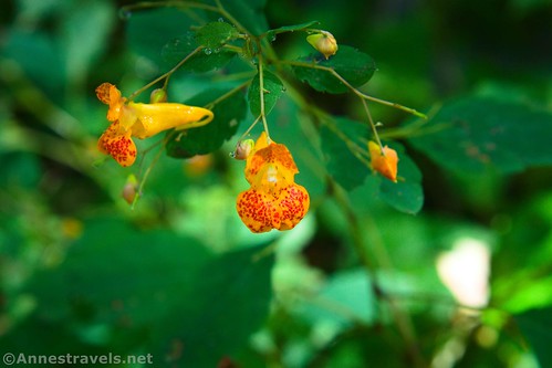
Continuing down the trail, I enjoyed many fall wildflowers (I visited in mid-September, before the colors turned). Go left (straight) when the Loyalsock Trail turns right a quarter of a mile beyond Warren’s Window.

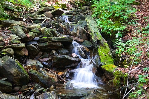
Just before reaching the road at mile 1.6, I passed a small waterfall on the right. It had rained for three days before I arrived, so this stream is probably seasonal.
At the road, turn right, then cross the campground road a tenth of a mile later. Cross over the main road (look both ways!) and pick up a faint trail that takes you down to the Loyalsock Creek.
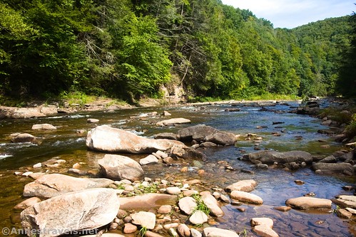
Turn right (upstream) on a decent path. This is the easiest trail you’ll see all day, so enjoy it (thus why I suggest you start at the end of this section – save the easy part for last!) It’s also a very enjoyable walk, with the gurgling river on the left. You can hear the road on the right sometimes, but otherwise you could be in the middle of nowhere except for the families enjoying the cool water of the creek.

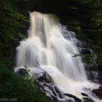
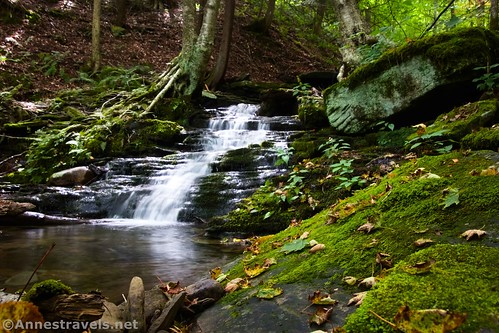
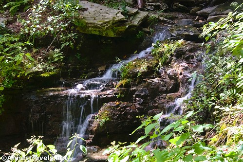
There is one “major” waterfall in Loyalsock Creek along this section. It’s a pretty little diversion.

Arrive at a large wooden arch at mile 2.6. This marks the official Canyon Vista Trailhead, and it’s where I’d start, where I to hike the trail again. (Just before the arch, you’ll pass a right turn that you’ll want to ignore.) Walk across the parking area, cross the road (look both ways!), and head up into the woods.
To me, this next section was one of the most difficult parts of the trail. The path steeply switchbacks through the trees without much in the way of views or wildflowers or anything else of interest. I was very glad to reach the Cold Run Junction (well-marked and yellow-blazed) at mile 3.4.

Turn left onto the Cold Run Trail. Note that if it’s been dry, Cold Run may not be worth hiking, and you can stay on the Canyon Vista Trail for a slightly shorter (if no less steep) hike. However, even if there is no water in the creek, the other end of the Cold Run Trail has some nice rocks and rock formations, so it’s still a nice addition to the Canyon Vista Trail.
Two-tenths of a mile after the junction, you’ll come upon a metal bench overlooking a view of the nearby hills (private property). I forget the story of this bench, but as I recall, it was installed in memory of someone who loved this view.

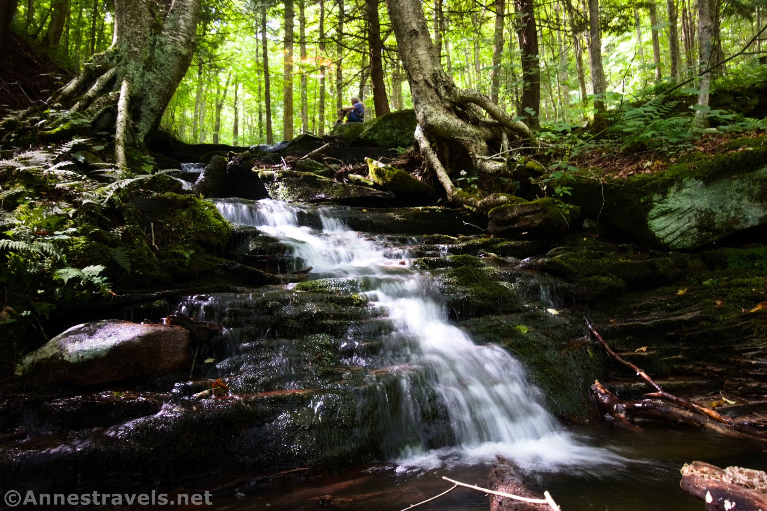
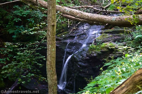
The trail switchbacks down into the gully after this, and 0.3 miles later, you’ll come to a social trail down to the creek. I took this down and was happily surprised to find a series of lovely waterfalls (by far the nicest on the Cold Run Trail). We ate lunch here, but not before I’d taken some photos I’m still proud of.
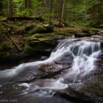
The trail travels up above the creek about 0.2 miles to Tecumseh Falls (difficult to see through the trees but still visible). Cross over a creek (not Cold Run, which is still below you on the left) and weave your way on the trail through the boulders to Aliquippa Falls a quarter mile later. The path does cross Cold Run here and works its way pretty much up to the top of this part of the hill in a forest.

Cross the creek again 0.3 miles beyond Aliquippa Falls; a tenth of a mile later, keep your eyes open for Cold Run Falls. It’s not the easiest to see or photograph, but I did my best.

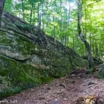
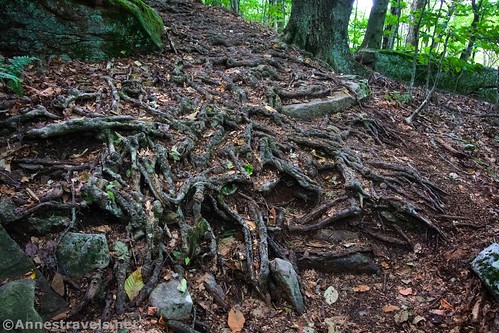
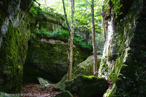
The trail leaves the stream at this point but continues through the forest. It picks up an old road about mile 4.9, but leaves it a short distance later (you’ll see more evidence of old roads on the Canyon Vista Trail later). The good news is that the trail fairly quickly enters a section of huge rocks and boulders.
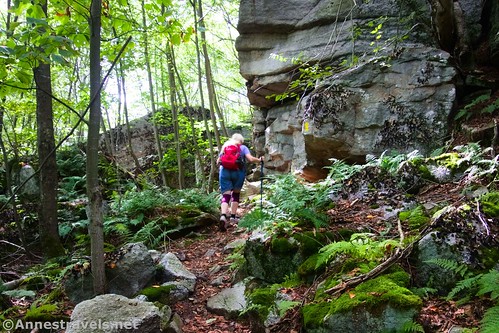
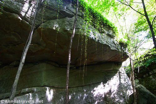
This area was my favorite part of the Cold Run Trail. The boulder arch was very neat to see at mile 5.1…

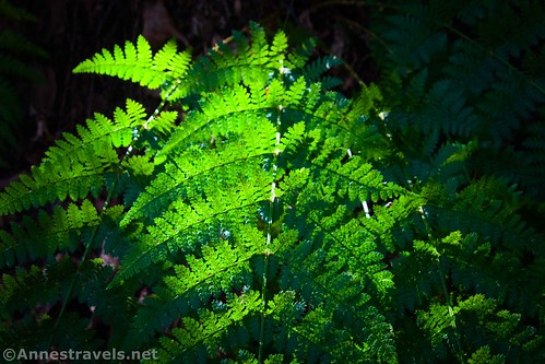
…then the trail enters a really fun area between giant rocks. The ferns, mosses, and tendrils of green were amazing!
Then, very suddenly, the Cold Run Trail ends at the Canyon Vista Trail at mile 5.4. But the boulder section isn’t finished yet! There are more boulders here and there for most of the rest of the trek back to Loyalsock Canyon Vista.

Pass by the viewpoint known as Prospect Rock at mile 5.8 (0.5 miles beyond the top end of the Cold Run Trail). Again, this view isn’t as good as either Loyalsock Canyon Vista or Warren’s Window, but it’s reasonable.
You’ll meet up with the Loyalsock Trail again 0.4 miles later. Take the Loyalsock Trail (yellow blazes with a red X) up to cross the gravel road after a quarter mile.
The trail continues on the other side of the road; be sure to turn right at the Link Trail shortly after the road crossing. From here, it’s a quick hike between large boulders back down to the Loyalsock Canyon Vista – the trail comes out on the road near the parking area.
Round Trip Trail Length: My GPS read 6.75 miles. It felt like more, but I was getting pretty tired by the middle of the Cold Run Trail!
Elevation Gain: 2,064ft. (1,143ft. to 1,805ft.)
Facilities: Restrooms at the Loyalsock Canyon Vista. You could probably find a restroom at the campground, but it would be a trek out of your way.
Fees: None
Trail Notes: Don’t underestimate the elevation gain on this trail – there is a lot of steep uphill and downhill. The trail is best after a good rain, when Cold Run is at its prime (it may even dry up altogether in the summer). As I’ve said elsewhere, I recommend beginning at the official Canyon Vista Trailhead (41.4691300°, -076.5632020°) (like I didn’t) and then hiking the loop clockwise (like I did). This means you get to see the waterfalls on Cold Run and Loyalsock Creek while hiking uphill, which will make the them more impressive.

Trail 
![]()
![]()
Road ![]()
Signs ![]()
![]()
Scenery ![]()
![]()
Would I go 100 miles out of my way for this? ![]()
Overall Rating: 
![]()

Canyon Vista Trail & Cold Run Trail GPS Coordinates
Loyalsock Canyon Vista Trailhead: 41.4624930°, -076.5749610° (41°27.74958′, -076°34.49766′ / 41°27’44.9748″, -076°34’29.8596″) (1,744ft.) (0.0)
Loyalsock Canyon Vista: 41.4628170°, -076.5752550° (41°27.76902′, -076°34.51530′ / 41°27’46.1412″, -076°34’30.9180″) (1,687ft.) (199ft.)
Ticklish Rock: 41.4604460°, -076.5759250° (41°27.62676′, -076°34.55550′ / 41°27’37.6056″, -076°34’33.3300″) (1,642ft.) (0.38)
Link Trail Junction: 41.4584150°, -076.5767100° (41°27.50490′, -076°34.60260′ / 41°27’30.2940″, -076°34’36.1560″) (1,535ft.) (0.56)
Vista: 41.4606230°, -076.5781550° (41°27.63738′, -076°34.68930′ / 41°27’38.2428″, -076°34’41.3580″) (1,428ft.) (0.76)
Warren’s Window: 41.4642620°, -076.5771290° (41°27.85572′, -076°34.62774′ / 41°27’51.3432″, -076°34’37.6644″) (1,381ft.) (1.04)
Loyalsock Trail Junction: 41.4641350°, -076.5748770° (41°27.84810′, -076°34.49262′ / 41°27’50.8860″, -076°34’29.5572″) (1,421ft.) (1.22)
Cross Road: 41.4677790°, -076.5712700° (41°28.06674′, -076°34.27620′ / 41°28’04.0044″, -076°34’16.5720″) (1,165ft.) (1.63)
Cross Campground Road: 41.4683180°, -076.5717200° (41°28.09908′, -076°34.30320′ / 41°28’05.9448″, -076°34’18.1920″) (1,157ft.) (1.71)
Vista Trail Trailhead: 41.4691300°, -076.5632020° (41°28.14780′, -076°33.79212′ / 41°28’08.8680″, -076°33’47.5272″) (1,181ft.) (2.60)
Trail Junction: 41.4693860°, -076.5630230° (41°28.16316′, -076°33.78138′ / 41°28’09.7896″, -076°33’46.8828″) (1,177ft.) (2.62)
Cross Road: 41.4698480°, -076.5642160° (41°28.19088′, -076°33.85296′ / 41°28’11.4528″, -076°33’51.1776″) (1,174ft.) (2.70)
Cold Run Junction: 41.4645140°, -076.5583230° (41°27.87084′, -076°33.49938′ / 41°27’52.2504″, -076°33’29.9628″) (1,507ft.) (3.4)
Bench View: 41.4628600°, -076.5553250° (41°27.77160′, -076°33.31950′ / 41°27’46.2960″, -076°33’19.1700″) (1,546ft.) (3.65)

Trail to falls: 41.4612910°, -076.5555560° (41°27.67746′, -076°33.33336′ / 41°27’40.6476″, -076°33’20.0016″) (1,450ft.) (3.93)
Falls: 41.4611590°, -076.5553340° (41°27.66954′, -076°33.32004′ / 41°27’40.1724″, -076°33’19.2024″) (1,433ft.) (3.96)
Tecumseh Falls: 41.4605470°, -076.5579330° (41°27.63282′, -076°33.47598′ / 41°27’37.9692″, -076°33’28.5588″) (1,609ft.) (4.18)
Aliquippa Falls: 41.4598100°, -076.5587070° (41°27.58860′, -076°33.52242′ / 41°27’35.3160″, -076°33’31.3452″) (1,633ft.) (4.33)
Cross Creek: 41.4595330°, -076.5602770° (41°27.57198′, -076°33.61662′ / 41°27’34.3188″, -076°33’36.9972″) (1,763ft.) (4.63)

Cold Run Falls: 41.4596670°, -076.5592580° (41°27.58002′, -076°33.55548′ / 41°27’34.8012″, -076°33’33.3288″) (1,697ft.) (4.71)
Meet old road: 41.4610990°, -076.5588150° (41°27.66594′, -076°33.52890′ / 41°27’39.9564″, -076°33’31.7340″) (1,731ft.) (4.91)
Leave old road: 41.4613580°, -076.5577290° (41°27.68148′, -076°33.46374′ / 41°27’40.8888″, -076°33’27.8244″) (1,704ft.) (4.97)
Boulder Arch: 41.4616910°, -076.5581080° (41°27.70146′, -076°33.48648′ / 41°27’42.0876″, -076°33’29.1888″) (1,756ft.) (5.09)
Cold Run/Canyon Vista Trail Junction: 41.4632810°, -076.5591620° (41°27.79686′, -076°33.54972′ / 41°27’47.8116″, -076°33’32.9832″) (1,746ft.) (5.38)

Prospect Rock: 41.4632810°, -076.5591620° (41°27.79686′, -076°33.54972′ / 41°27’47.8116″, -076°33’32.9832″) (1,629ft.) (5.80)
Loyalsock Trail Junction: 41.4647200°, -076.5686070° (41°27.88320′, -076°34.11642′ / 41°27’52.9920″, -076°34’06.9852″) (1,630ft.) (6.22)
Cross road: 41.4636010°, -076.5703610° (41°27.81606′, -076°34.22166′ / 41°27’48.9636″, -076°34’13.2996″) (1,720ft.) (6.41)
Link Trail Junction: 41.4628730°, -076.5703700° (41°27.77238′, -076°34.22220′ / 41°27’46.3428″, -076°34’13.3320″) (1,781ft.) (6.47)
End: 41.4625220°, -076.5748200° (41°27.75132′, -076°34.48920′ / 41°27’45.0792″, -076°34’29.3520″) (1,745ft.) (6.76)
The gpx file for Canyon Vista Trail and Cold Run Trail can be downloaded – please note that this and the GPS Coordinates are for reference only and should not be used as a sole resource when hiking this trail.
Download GPX File size: 126.7 KB Downloaded 333 times
(Note: I do my best to ensure that all downloads, the webpage, etc. are virus-free and accurate; however, I cannot be held responsible for any damage that might result, including but not limited to loss of data, damages to hardware, harm to users, from use of files, information, etc. from this website. Thanks!)

Getting to Loyalsock Canyon Vista & the Canyon Vista Trailhead
If traveling from the east on I-80 (so traveling I-80W), take Exit 232 onto PA-42N. Drive 10.4 miles; turn right to stay on PA-42N. After 7.9 miles, turn left onto PA-118W for 0.3 miles. Turn right onto PA-42N. After 7.4 miles, turn right onto US-220N. Drive 1.1 miles and then turn left onto PA-42N for 4.4 miles. Turn left onto Worlds End Road for 5.7 miles; turn right onto PA-154E. The Canyon Vista Trailhead will be on your right 1.2 miles later. To continue up to Loyalsock Canyon Vista, keep driving another 0.6 miles to the Worlds End State Park Campground. Turn left by the campground, but don’t take another left into the campground, itself. Instead, take the gravel road 1.4 miles uphill; take another left for 0.7 miles to the Loyalsock Canyon Vista (sign on the right, parking on the left). The road is safe for low-clearance vehicles (I was driving a Honda Fit – and if you know what type of clearance that doesn’t have, you’ll understand why I say it’s low-clearance friendly!)
If traveling from the west on I-80 (so traveling I-80E), take Exit 212B onto I-180W. After 12.4 miles, take Exit 13 for PA-405 toward Muncy/Hughesville; turn right onto PA-405N for 0.3 miles. Stay on PA-405N (Water Street) by turning slightly right and then slightly right again. Use the left lanes to turn left to stay on PA-405N for another 3.2 miles. Continue straight onto US-220N for 13.1 miles. Turn left onto PA-42N for 4.4 miles, then turn left onto Worlds End Road for 5.7 miles. The Canyon Vista Trailhead will be on you right 1.2 miles later. To continue up to Loyalsock Canyon Vista, keep driving another 0.6 miles to the Worlds End State Park Campground. Turn left by the campground, but don’t take another left into the campground, itself. Instead, take the gravel road 1.4 miles uphill; take another left for 0.7 miles to the Loyalsock Canyon Vista (sign on the right, parking on the left). The road is safe for low-clearance vehicles (I was driving a Honda Fit – and if you know what type of clearance that doesn’t have, you’ll understand why I say it’s low-clearance friendly!)

This Week’s Featured Product!
Discover more that the Keystone State has to offer with this book to 50 of its best trails. From waterfalls and history to mountains and valleys, this book is a great guide. Learn more here.