

What do you do when you’re suddenly stuck in a strange town because your vehicle has broken down? Whenever possible, I try to make lemonade out of our lemon – or as I said when we were stranded for three days in Lincoln, NE, “make Lincolnade”. This can mean burning time by strolling around residential districts, but often towns have something better to offer, if only a small park with a playground. St. George, UT, however, offered us something much better than a playground at its Pioneer Park. This parcel of land on the outskirts of the city is simply chock-full of Utah bouldering opportunities, rock formations, slot canyons, arches, and even moqui steps! We spent at least half a day exploring, even eating lunch at the picnic shelter in the park. Better yet, besides parking areas, there is a paved walking / biking path that goes right by the park – so the opportunities for getting to it are as endless as the opportunities exploring it!
Quick Stats
(Affiliate links are present on this page.)
Maybe I should give a little background before I describe the park itself. While visiting Zion National Park last spring, as we were driving out of the visitor center parking lot, our van suddenly stopped cold – not a hint of anything; it just stopped and wouldn’t start again. Thankfully, there was a phone at the visitor center, which we could use to call AAA. The tow truck came and hauled all of us and our van over to St. George, because that was the nearest city with an AAA approved repair shop. (And now you know why we have AAA – beyond the annual membership, the 40-mile tow didn’t cost us anything!) Since the next day was Sunday, and therefore the shop wouldn’t be open, we knew we had an entire day to spend doing something within walking distance. Following a local’s vague directions, we stumbled onto Pioneer Park, which turned out to be a lovely way to spend an otherwise wasted vacation day.
Because we were walking, we approached Pioneer Park via the walking / biking path that goes along the Red Hills Parkway. The local had told us to go to the big rock with “Dixie” painted on it. (This rock is apparently also called the “Dixie Sugarloaf”.) A tunnel underneath the highway leads from the walking / biking path almost to the base of the Sugarloaf, and a parking area is close by. Going around to the back side of the rock, there is a way to walk up to a metal bridge that spans the gap between some smaller boulders and the Sugarloaf. However, if you’re more adventurous (like us) there are some moqui steps just to the left of the bridge that also give access to the top of the Dixie Sugarloaf. (However, if you’ve also had experience with moqui steps (like us), you’ll come up the moqui steps and down via the bridge – the steps are very easy to climb, and very difficult to come back down!) The rock itself is pretty cool, but if you walk to the front side of the boulder there are views down over St. George.
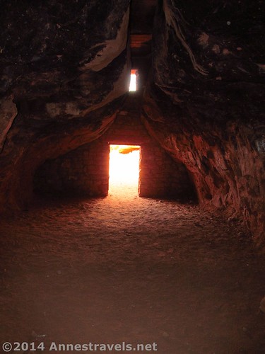
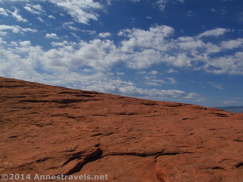
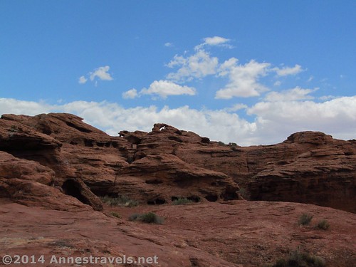
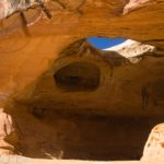
From here, we wandered vaguely southeast, generally following (what I found out later was) the Dixie Overlook Trail. This led past some cool boulders, but the most interesting thing was a house-like cave that someone had built between two huge boulders that nearly come together making a roof. There is a chimney, and someone bricked up the entrance leaving only a doorway. Very cool! Also, if you’re into scrambling, the boulders here would be a great place to do it. Armature rock climbers also practice on the side of the Dixie Sugarloaf.
Eventually, we made our way down to a large, round picnic shelter. Apparently, this is reversible, but since no one was there, we at lunch in its shelter. There was a drinking fountain near the shelter, and second parking area nearby.
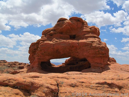
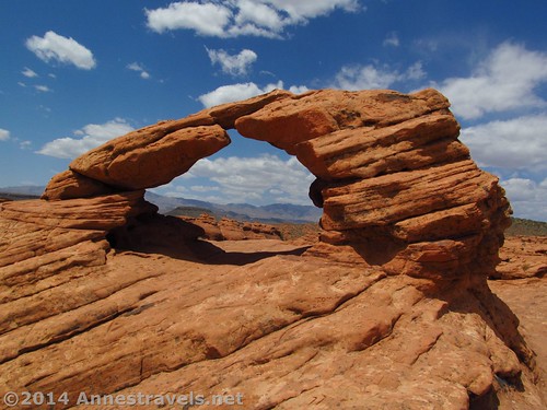
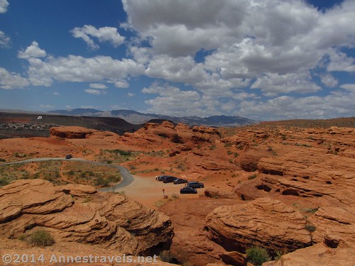
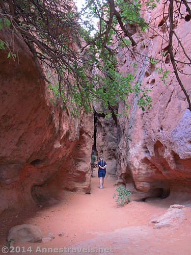
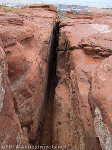
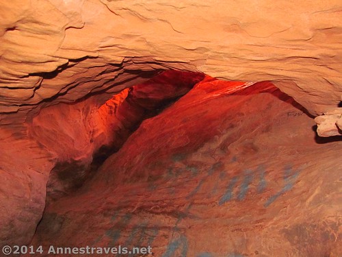
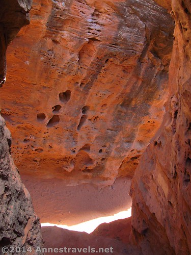
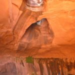
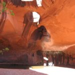
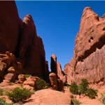
From here, some of the group took the road that winds through a boulder-strewn area, while others of us scrambled over the rocks, to get to the far side of the loop road that goes through the park. (Several more single-serve picnic shelters are located along the road.) Rounding a bend in the road (past yet another parking area) we could see some slot canyons – that looked interesting! However, they were in use by another party, so we scrambled up the nearby cliff (to the right as you drive into the parking area). Here we found two small arches in the rocks. These are covered in graffiti, but they’re still interesting to look at and explore. We wandered around on top of the cliffs for a while, enjoying the rustic views (ok, and hiding out of the heat-of-the-day sun in the shade of a boulder) before heading over to the slot canyons. The one we explored had several off-shoots; I chimneyed up one of these, met the others at the far end of the canyon, and then came back down with them. The canyon is narrow (several of us had to go sideways), but it’s very doable (and not dangerous) if you like tight spaces.
Overall, I think we spent at least three hours exploring, and we definitely could have stayed longer. There are more slot canyons, and probably more arches and cool formations. However, we were tired and ready for the longish walk back to the repair shop.
So here’s the bottom line on Pioneer Park: If you’re in the area and need something to do…and you like exploring, bouldering, or slot canyoning…it’s a great place to stop in for a few hours!
You can also explore the Red Hills Desert Garden, adjacent to Pioneer Park!
Round Trip Trail Length: Varies; probably 1-2 miles (2-3 km) of exploring
Starting Elevation: Around 3,000 ft. (915 m)
Highest Elevation: Around 3,125 ft. (950 m)
Net Elevation Change: Approximately 125 ft. (35 m)
Facilities: Drinking fountain, picnic tables, port-a-potties in the parking area near the large picnic shelter
Fees: None
Trail 
![]()
![]()
![]()
Road ![]()
![]()
![]()
Signs ![]()
![]()
![]()
![]()
Scenery
Would I go 100 miles out of my way for this?
Overall Rating: ![]()
![]()
Key GPS Coordinates for Pioneer Park
Moqui Steps: 37.11573N / -113.57974W (37° 6′ 56.6274″ / -113° 34′ 47.064″) (3,071ft.; 936 m)
Cave (house): 37.11557N / -113.57745W (37° 6′ 56.0514″ / -113° 34′ 38.8194″) (3,039ft.; 926 m)
Big picnic shelter: 37.11537N / -113.57867W (37° 6′ 55.3314″ / -113° 34′ 43.212″) (3,019ft.; 920 m)
Arch 1: 37.11668N / -113.57528W (37° 7′ 0.048″ / -113° 34′ 31.008″) (3,111ft.; 948 m)
Arch 2: 37.11665N / -113.57507W (37° 6′ 59.9394″ / -113° 34′ 30.2514″) (3,129ft.; 953 m)
Slot 1: 37.11687N / -113.57581W (37° 7′ 0.7314″ / -113° 34′ 32.916″) (3,063ft.; 933 m)
Slot 1 Top: 37.11751N / -113.57558W (37° 7′ 3.036″ / -113° 34′ 32.088″) (3,124ft.; 952 m)
Getting to Pioneer Park
If you’re coming from the south, on I-15 in St. George, take Exit 8 toward St. George Blvd E; turn left onto St. George Blvd W and drive 0.3 miles (0.4 km). Alternatively, if you’re coming from the north, on I-15 in St. George, take Exit 8 toward St. George Blvd; turn right onto St. George Blvd W for 0.1 mile (0.1 km). If coming from either direction, turn right onto 1000E for 0.2 miles (0.3 km). At the light, turn left onto Red Hills Parkway and drive 0.8 miles (1.2 km). The entrance to Pioneer Park will be on your right. If you’d rather park next to the Dixie Sugarloaf, pass the Pioneer Park entrance and drive past the big rock with “Dixie” painted on it. A parking area can be accessed not long after the rock.
Zoom map out to browse nearby hikes & places of interest
This Week’s Featured Product!
Looking for more in Utah’s Canyon Country? This book details 90 hikes in southern Utah, from St. George to Moab, giving hikers a chance to “Wow!” over canyons, rock formations, and more!


2 responses to “Pioneer Park: A Place to Explore Utah”
[…] Pioneer Park, St. George, Utah. I only found this place because a guy who owned a garage (very drunk) was telling us about all the great things we could do in his city while we waited for our van to be fixed. Still, Pioneer Park is a gem, with so many sandstone rocks, caves, slot caves, arches, and more just waiting for anyone who wishes to wander around and find it. […]
[…] in Pioneer Park, […]