

Hidden Lake Lookout! What a trail that promised much and delivered more! The name evokes pictures in my mind of a half-frozen lake, rocky crags still studded with snow, and wildflowers galore along the trail. Its 9.3 mile length also makes me think of partying girls and bear hunting, but more on that later. The North Cascades certainly offer stunning scenery to the hiker who doesn’t mind a little show and a little scrambling to reach an old fire-lookout perched precariously atop a high, craggy peak. Need I say more?
Quick Stats
(Affiliate links are present on this page.)
We spent the night at the Hidden Lake trailhead, figuring we could make an early start the next morning. However, someone else made an even earlier start: as we were eating breakfast, a big old jeep drove in and a 30-something guy, built like a tank, hopped out, grabbed his gun and rucksack, and was hiking up the trail in less than 30 seconds flat. We were a bit startled – we knew bear season had begun the day before, but if it hadn’t been for the man’s sureness and obviously knowing what he was doing, we’d have been scared to death to even begin the hike.
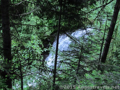
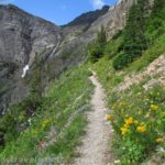
But begin it we did, making lots of noise and keeping close together as the trail hurried upward through the trees and along a stream. (Sometimes the trail became the stream, but this section of the trail is quite well-maintained, so we didn’t get our feet wet…here at least.) Just before we hit 1 mile, there was a small waterfall over the left. It was hard to see, but it was nice to know we were getting someplace.
After about a mile, the trail suddenly broke out of the trees to enter a meadow. There was no sign of the bear hunter, so we switchbacked upward on the very steep trail, singing, talking loudly, anything to make lots of noise.
Then we heard it: One loud report, up the ridge on our left. We jumped, but grinned at each other. If he only used one shot, he’d gotten his bear, and we were good from now on. Still, we didn’t drop the noise level for a while.
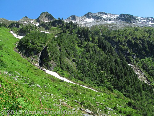
It was in this meadow-and-switchback section that we began to get wet feet. The snowmelt up higher was swelling the streams, making the few crossings into swamps instead of rock-hops.

At last, we crested the last of this set of switchbacks and crossed the stream. From here, the trail works its way along the side of the ridge, rising upward, but not at the alarming rate it did through the meadow. It also becomes rockier, but it’s still a fairly good trail, and even the (multiple) stream crossings aren’t too bad.

While crossing a rock field, a young woman came up behind us and asked us if we were planning to spend the night in the fire tower (it’s open on a first-come, first-serve basis during the summer). No, we were just day hiking. To this she looked rather relieved – she and a couple friends were having a bachelorette party there and were racing to the top to claim it before anyone else. They got it, too – we met them at the top, a couple hours later, placidly sunbathing on the rocks outside the lookout.
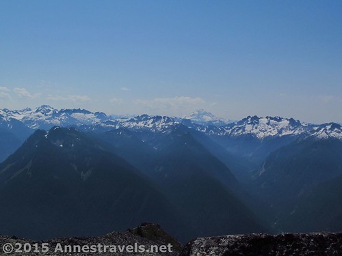
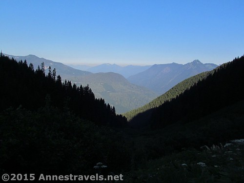
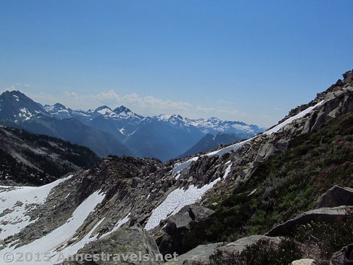
In this section, the views were all behind us on the way out. Mt. Baker and Mt. Shucksan were both visible, along with other jagged Cascade peaks. Wow!
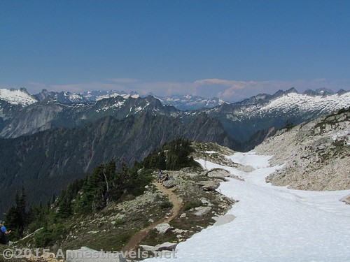
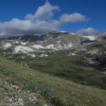
As we neared the saddle between two huge, towering peaks, we began to run into snow. Mind you, it was only the beginning of August, so we were more surprised that there was so little snow than that there was snow covering our path. At first it was easy to either skirt the snow on rocks or to follow the well-trampled path of hikers before us. Before the saddle, however, the trail disappeared completely and we had to follow other hikers’ boot-tracks. It was a little scary following the crowd, but since we more or less knew where we were headed, we figured that even if someone got off the trail, we’d all meet up in the saddle. BTW, in this section, you can see the lookout, high on the right-hand peak, looking something like an alpine monastery high in the Alps. Or do I have a vivid imagination?
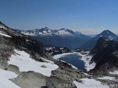
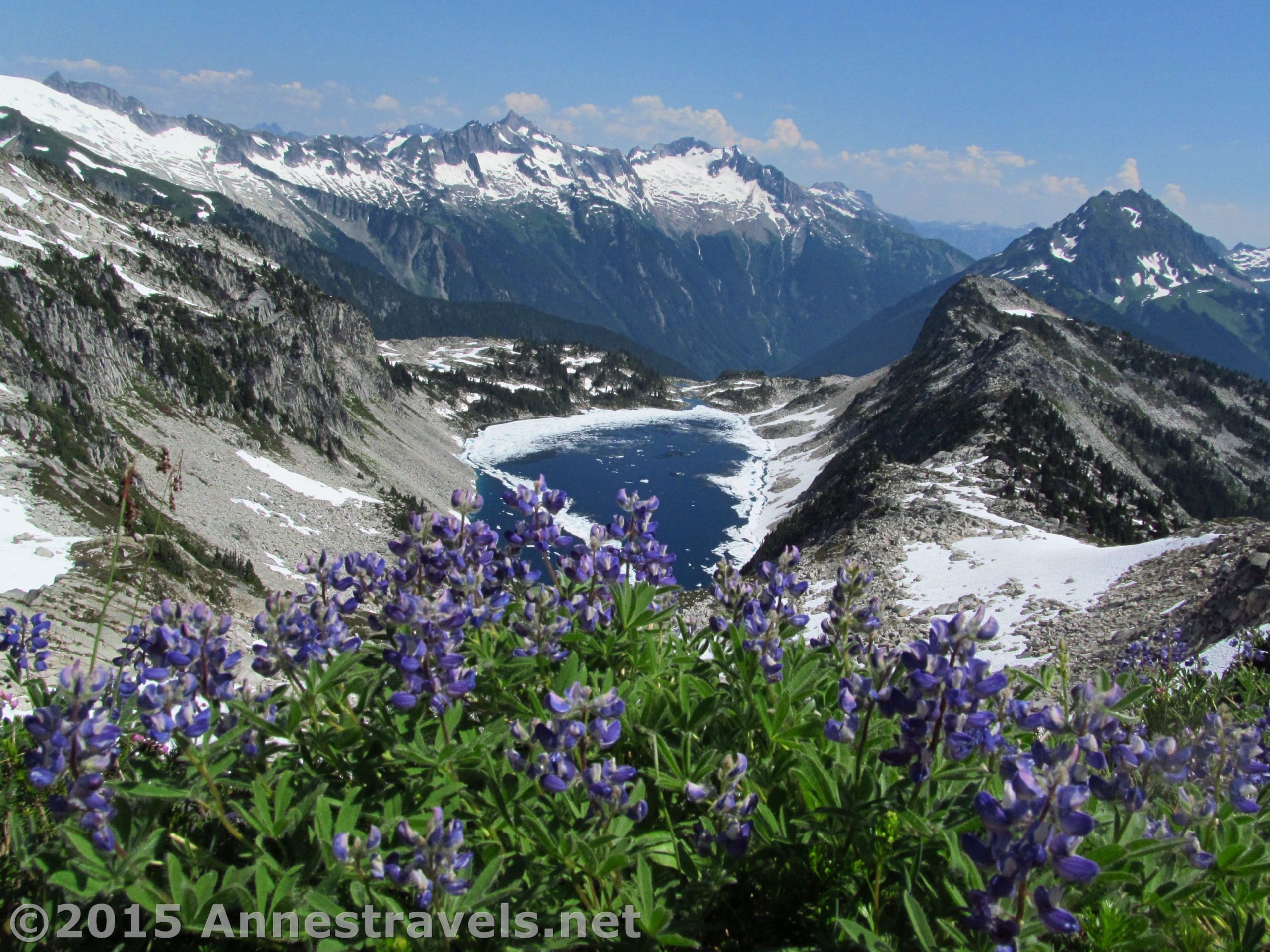
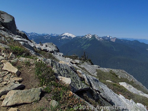
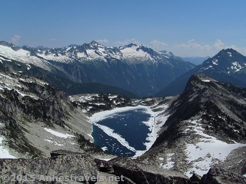
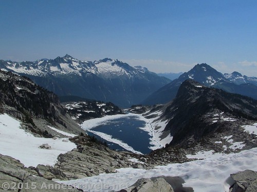
Coming over the snow-filled saddle at 4.3 miles took my breath away. On the horizon were a row of jagged peaks; below was Hidden Lake, still half-frozen, in a hidden valley. Wow! Amazing! It would have been worth the hike just to see this view!
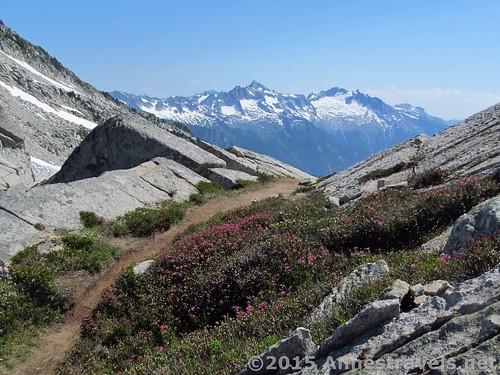
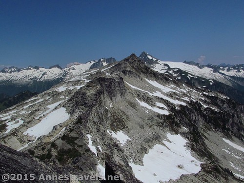
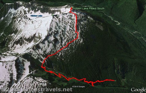
But some of us like adventure, and that means finishing trails whenever possible. So, following the numerous social trails that appeared out from under the snow, we began to ascend the peak to the Hidden Lake Lookout. At first, this was very difficult, as the real trail was under snow, so we had to make our own way along the precarious scree field on the side of the peak. Once we picked up the trail, however, things got easier (except for the rock scrambles, but even those weren’t too bad). Almost a half a mile beyond the saddle, we at last crested the peak!
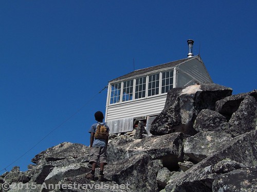
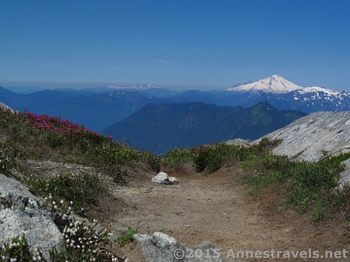
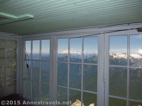
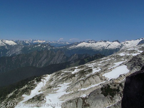
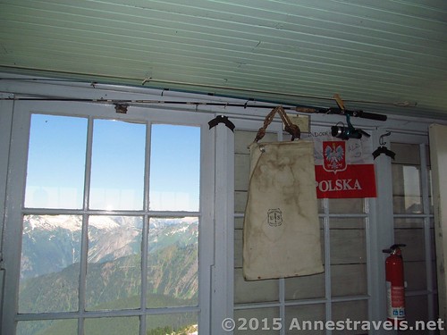
The fire lookout sits on the rocks. We went inside and looked around – there is a fair amount of old equipment, and the view is good, too, toward Mt. Baker, Mt. Shuksan, Glacier Peak, and beyond!
Some of us scrambled up to the very highest point of the peak – I don’t recommend this as the mammoth rocks aren’t very stable and it seemed to be quite dangerous. Only one person (thanks to his long legs) made it to the very top, and he kindly took pictures for the rest of us.
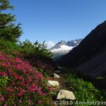
After a snack, it was time to descend. All the way down, we had fabulous views over Hidden Lake, with some really nice lupines, too.
The best part descending from the saddle, though, was cautiously sliding down all those snowfields – what fun!
And that bear hunter? Other hikers told us they’d seen the hunter carrying his prize back to the parking area. Glad he got his bear…and hopefully I won’t be so close next time 🙂
Round Trip Trail Length: 9.3 miles
Lowest Elevation: 3,636ft. (Trailhead)
Highest Elevation: 6,862ft. (Hidden Lake Lookout)
Net Elevation Change: 3,226ft.
Facilities: None.
Fees: $5/day for a Northwest Forest Service Pass. You won’t be in North Cascades National Park until the saddle, so you have to pay for the pass, not for the national park. Alternatively, America the Beautiful (Interagency), Senior (Golden Age), Access (Golden Access), Volunteer, Military, and Northwest Forest Service Annual Passes can be displayed. Discovery Passes not accepted!
Trail 
![]()
![]()
Road ![]()
![]()
![]()
Signs ![]()
![]()
![]()
![]()
Scenery
Would I go 100 miles out of my way for this?
Overall Rating: ![]()
![]()
Key GPS Coordinates
Hidden Lake Parking: 48.51423N / -121.22162W (48° 30′ 51.2274″ / -121° 13′ 17.832″) (3,418ft.)
Trail beginning: 48.51423N / -121.22141W (48° 30′ 51.2274″ / -121° 13′ 17.076″) (3,634ft.) (ended 9.3)
Waterfall: 48.451574N / -121.21120W (48° 27′ 5.6664″ / -121° 12′ 40.32″) (4,094ft.) (0.8) – meadows begin about 1 mile from TH
Saddle / Overlook: 48.49670N / -121.20376W (48° 29′ 48.1194″ / -121° 12′ 13.536″) (6,552ft.) (4.3)
Hidden Lake Lookout: 48.49545N / -121.20523W (48° 29′ 43.6194″ / -121° 12′ 18.828″) (6,862ft.) (4.7)
The gpx file for the Hidden Lake Lookout Trail can be downloaded – please note that this and the GPS Coordinates are for reference only and should not be used as a sole resource when hiking this trail.
Download GPX File size: 254.9 KB Downloaded 791 times
(Note: I do my best to ensure that all downloads, the webpage, etc. are virus-free and accurate; however, I cannot be held responsible for any damage that might result, including but not limited to loss of data, damages to hardware, harm to users, from use of files, information, etc. from this website. Thanks!)
Getting to the Hidden Lake Lookout Trailhead
From Marblemount, WA turn onto Cascade River Road and drive 9.7 miles. Take a left onto an unmarked dirt road (NF-1540) that works its way very steeply uphill. The road ends, 4.5 miles later, at the Hidden Lake Lookout Trailhead. (Road notes: First, high clearance is highly advised. You can do it in a low-clearance car – I saw enough of them at the trailhead – but you’ll have to take it very slowly and carefully. Second, be extremely careful around the many blind corners in the road. It’s really only one lane wide, so passing is optional, or so it seems!)
Zoom map out to browse nearby hikes & places of interest
This Week’s Featured Product!
If you want to get the best of the best out of hiking in Washington, try this book. I’ve compiled some of my favorite hikes in the state, including a large variety near North Cascades National Park.

6 responses to “Hidden Lake Lookout: A Most Fabulous View!”
[…] Hidden Lake Lookout, North Cascades National Park, Washington. One of my favorite (in terms of spectacular) hikes in Washington state (well, outside of the Mt. Baker area, anyway)! The views are never-ending after the first couple miles, and the gem of a lake, hidden in a craggy cirque, is just too beautiful to pass up! 9.3 miles with 3,226 ft. of elevation gain. […]
[…] the Olympic Peninsula) meets all this criteria. We were trying to get between the North Cascades (Hidden Lake, to be exact) and Olympic National Park (specifically, Third Beach), so this ferry was very much on […]
[…] Hidden Lake, North Cascades National Park, Washington […]
[…] Hidden Lake. The views from Hidden Lake Pass or and Hidden Lake Lookout are just plain epic. That’s all I can say. Peak upon peak (including Mount Baker and Glacier Peak) stretch away in every direction, the trail traverses lovely meadows, and the views of Hidden Lake so far below left me in total awe. 6 (pass) to 9.3 (lookout) miles RT […]
[…] boots or sneakers? Some manufacturers are blurring the line between the two, if only in style. Atop Hidden Lake Lookout Peak, […]
[…] 10 of the Best Hikes in and around North Cascades National Park – picture from the saddle below Hidden Lake Lookout […]