

Last summer, after we climbed Wheeler Peak (the highest point in New Mexico), we also wanted to climb Gold Hill. However, everyone was pretty worn out after hiking above 13,000ft., so we decided to take a rest day in between. In the afternoon, I said, more or less, we can’t just sit around because we’ll all stiffen up, and then Gold Hill won’t be any fun at all! Let’s take the Gavilan Falls Trail and see where we end up!
Quick Stats
(Affiliate links are present on this page.)

Well, no one was in the mood to just “see where we end up”, so they convinced me to make Gavilan Falls the destination, and we wouldn’t go any further up the trail! Negotiations settled, and feeling better because it’s much cooler up in the Taos Ski Valley than down in Taos, we parked at the Forest Trail No. 60 Gavilan Trailhead.
The map at the trailhead kiosk didn’t show the falls, but that didn’t dissuade us (the internet said it existed, so it must be there, right?) We set out up the trail marked as the Gavilan Tr. 60 (Gold Hill 7, Lobo Peak 6).

The trail works its way up behind some of the ski lodges, then strikes left up into the forest. It’s an old road, so it’s nice and wide (and very rocky). But it also goes uphill – just about the entire hike is uphill, though some parts are steeper than others.
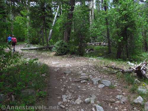
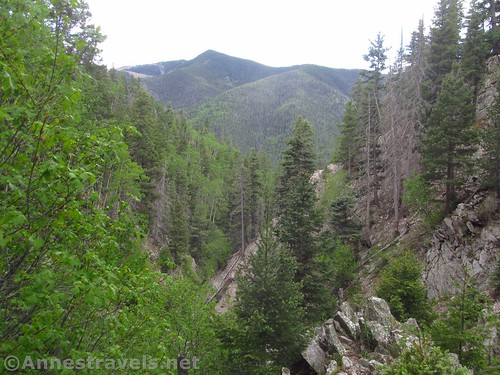
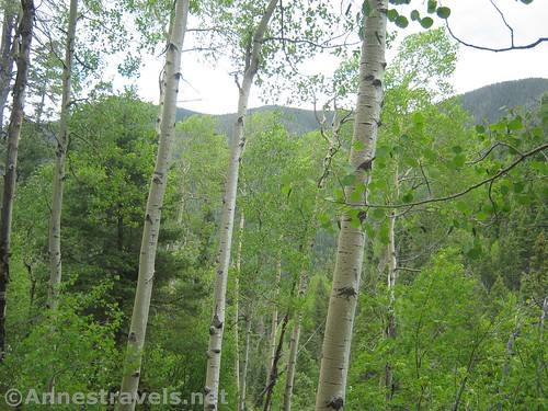
After almost 0.4 miles, the trail enters the Columbine-Hondo Wilderness (most of the hike up to this point was in Carson National Forest). The views are very limited by the pines and aspens, but since the sun was under clouds, it was a pretty lush walk through the forest. The Columbine were out, along with a few other wildflowers, so that made for color among the greenery.
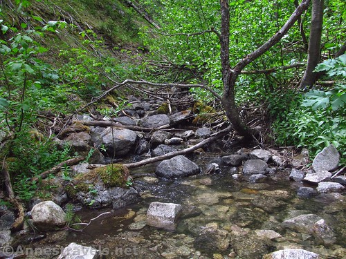
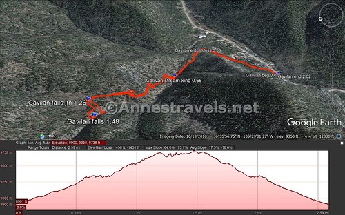
The trail takes a slight dip at 0.66 miles to cross Gavilan Creek (rock hop). Here half my group stayed behind to play in the water while the rest of us continued up the trail. In some ways, they couldn’t have chosen a better spot because the trail began to climb in earnest at this point. It’s now a trail, for sure, switchbacking upward at an alarming rate. We hoofed it up because we had limited time and I, for one, wanted to get to Gavilan Falls before our time ran out!
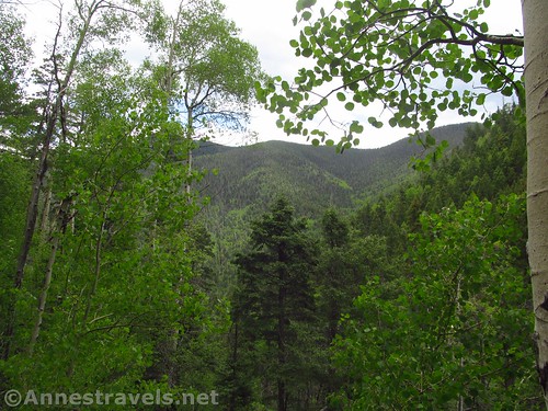
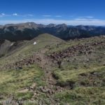
After finishing its initial climb from the stream, the trail turns to continue upcanyon. Everyone we passed coming down told us how beautiful the meadows were. “You’ll love them!” one young lady told me. “They’re so beautiful! One of the most beautiful places I’ve ever seen!” I vaguely wished we were going up there, but that would have to wait for another day – we were going to Gavilan Falls, not beyond. Looking at the photos on Hiking Project, the views remind me of some of what we saw on the lower meadows/ridgeline of the Gold Hill Trail, and if that’s correct, they really are extremely beautiful!

Just about the time we were about to turn around (with limited time, you can’t go too far – especially if your hiking companions are waiting for you), we finally came across the little wooden sign on a tree pointing toward Gavilan Falls, ¼ mile. The junction is about mile 1.25. We turned left to follow the trail through the forest.

The only problem was that while the trail started out as a trail, it fairly quickly disappeared in deer trails, social trails, and no trails. We followed the best ones we could (thankfully one of my group members is pretty good at finding trails). At last we ended up at a slope where the trail had slid down the hillside in a tangle of red dirt. Several social trails attempted to negotiate the slide, but we finally picked our way across the side of the slope, the people on stable(ish) ground holding up those on less-stable ground. In about a half dozen strides, we were over the slide and into the forest.
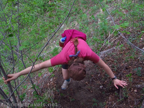
I’d say most people turn around at the slide because the vague trail became vaguer. We mostly followed our instincts and the sound of water toward the creek, then took the plunge (hang on to all those aspen saplings!) when we thought we were close.
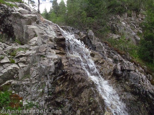
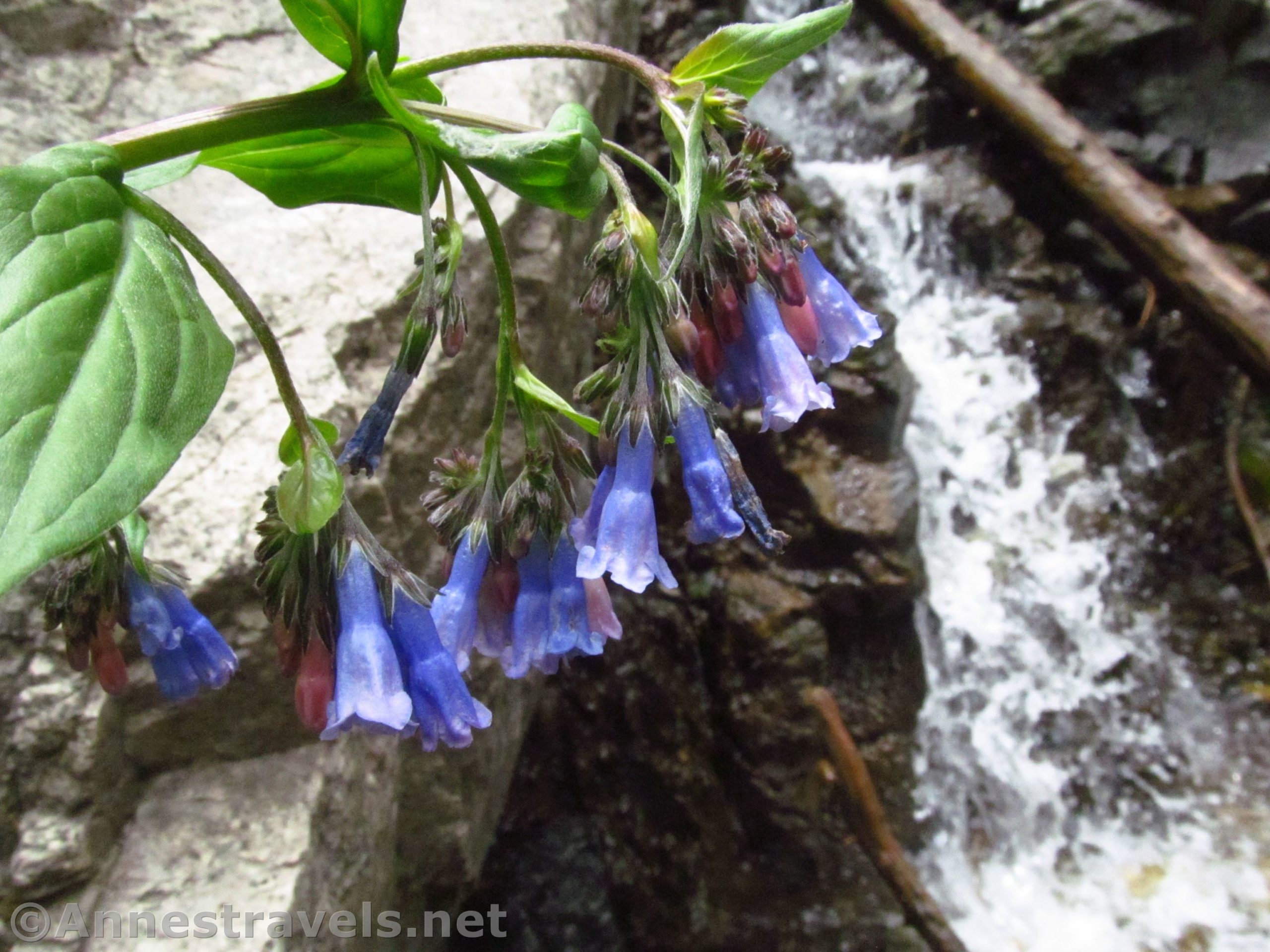
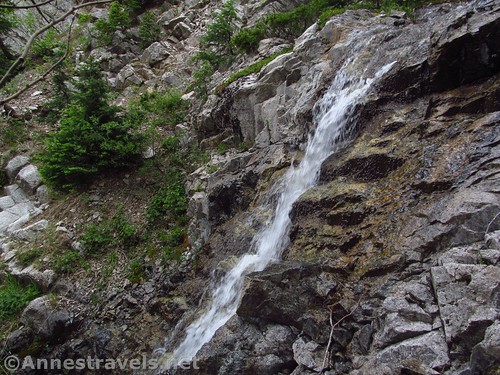
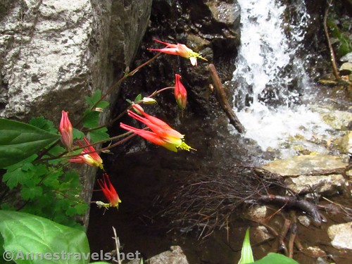
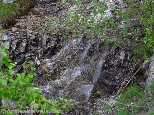
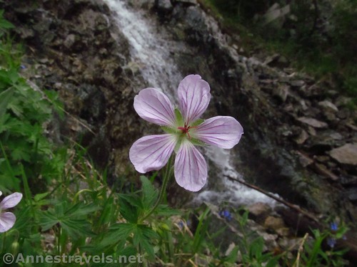
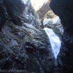
We came down right to the side / base of Gavilan Falls just before mile 1.5. It has at least two main tiers; from here we could see the bottom one, but there is another set of falls not far above the lower cascade. We rock-hopped across the river, took too many pictures, and admired the wildflowers growing nearby.
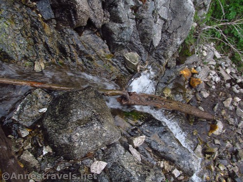
Several of us scrambled up the left side of the falls for a better view. It was tempting to move the log that was across the falls – it wouldn’t have been hard – but I decided to keep it natural. From what I can tell, the water flow in late May after a very low snow year was about the same as another photographer found in September.

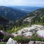
Looking downcanyon, there were some pretty good views, too, though they would have been nicer on a sunnier day.
Eventually we scrambled up the right side of the falls (there might have been a trail – maybe) to take a slightly different route back to the main Gavilan Trail. We followed the best-path-finder group member over hill and dale, but there’s no question that he got us back to the main path, probably with less pain than trying to retrace our steps. Either way, be prepared for a steep woods scramble if you want to see the falls.
We got back to the creek crossing where we had left the rest of the group just in time before they went back to the van, so we were able to finish the hike together. Overall, moving pretty quickly despite the steepness of the trail, I think it took us 2-3 hours total (including scrambles, finding the trail, and enjoying the falls for 15 minutes or so). It’s not a long hike, but if you need a destination, Gavilan Falls is a nice little adventure!

Round Trip Trail Length: I ended at 2.8 miles
Vertical Elevation Change: 785ft. (8,926ft. at the trailhead to 9,711ft. at the Gavilan Falls Trail Junction)
Facilities: None at the trailhead. Restrooms, picnic area, and visitor services available in the Taos Ski Valley, just up the road from the trailhead.
Fees: None
Trail Notes: You really do have to scramble for this one. Be familiar with wayfinding / bushwacking in the woods before you go. The falls aren’t the biggest or most spectacular, but it’s pretty nice all the same. I’d highly recommend making time to go up to the meadows, too.
Trail 
![]()
![]()
Road ![]()
Signs ![]()
Scenery ![]()
![]()
![]()
Would I go 100 miles out of my way for this? ![]()
![]()
Overall Rating: ![]()
![]()
GPS Coordinates for Gavilan Falls
Trailhead: 36.5934833°, -105.4843333° (N36° 35.609′ W105° 29.060′ / 36°35’36.5400″, -105°29’03.6000″) (8,926ft.) (0.0) (2.82)
Enter Columbine-Hondo Wilderness: 36.5970000°, -105.4813667° (N36° 35.820′ W105° 28.882′ / 36°35’49.2000″, -105°28’52.9200″) (9,146ft.) (0.38)
Stream Crossing: 36.5991667°, -105.4843833° (N36° 35.950′ W105° 29.063′ / 36°35’57.0000″, -105°29’03.7800″) (9,314ft.) (0.66)
Gavilan Falls Junction: 36.6029500°, -105.4863833° (N36° 36.177′ W105° 29.183′ / 36°36’10.6200″, -105°29’10.9800″) (9,711ft.) (1.26)
Gavilan Falls: 36.6028333°, -105.4874167° (N36° 36.170′ W105° 29.245′ / 36°36’10.2000″, -105°29’14.7000″) (9,673ft.) (1.48)

The gpx file for Gavilan Falls can be downloaded – please note that this and the GPS Coordinates are for reference only and should not be used as a sole resource when hiking this trail. For the gpx file back down to the trailhead via Long Canyon, click here (post coming soon!)
Download GPX File size: 63.6 KB Downloaded 410 times
(Note: I do my best to ensure that all downloads, the webpage, etc. are virus-free and accurate; however, I cannot be held responsible for any damage that might result, including but not limited to loss of data, damages to hardware, harm to users, from use of files, information, etc. from this website. Thanks!)
Getting to the Gold Hill Trailhead
From Taos, New Mexico, drive north on US-64W. Outside of town, turn right on NM-150N, turning away from the The Rio Grande Gorge Bridge (which is a worthy destination unto itself.) (If you’re coming in from the north, take this turn where NM-522S meets US-64 – turn left toward the Taos Ski Valley).
Follow the NM-150N for almost 13 miles (a GPS is useful, but not required). You’ll pass through typical northern New Mexico plains, then enter an alpine canyon more fit for Colorado – it’s a beautiful (if steep) drive. Just before the Austing Haus Lodge (the first of the main lodges in the Taos Ski Valley – you can’t miss it because it looks like something out of Austria, including brightly painted edelweiss on the buildings), a brown sign will point to the trailhead aka a wide gravel spot on the edge of the road.
Zoom map out to browse nearby hikes & places of interest
This Week’s Featured Product!
For even more hikes in the area surrounding Taos, try this book with excellent maps of each hike.

One response to “Exploring to Gavilan Falls”
[…] Everyone was tired the next day, so in the afternoon we took a little stroll/bushwack up to Gavilan Falls. […]