
Webster Park, in the northeastern corner of Monroe County, is one of the area’s premier hiking areas. Trails wind through 550 acres of swamps, hardwood forests, peaceful pinewoods, and meadows, offering solitude (though you will see people, especially on a nice weekend) and a quiet place to recharge your wilderness batteries. I’ve hiked the trails (and deer trails) of the park for my entire life, so here I’ll share my favorite moderate-difficulty loop in Webster Park – mostly in the depths of a pinewood with a peaceful stream near the trail (in other words, peaceful and shaded).
This is the Moderate Loop Hike – it is a peaceful hike through a pine forest along a creek. For the Easy loop hike showcasing the fishing pier, Mill Creek, and nearby grassy meadows, click here. For the “Webster Park Grand Tour”, click here.

The Best Moderate Loop Hike in Webster Park
Quick Stats
Start at the parking area near the road to the campground. It’s a peaceful parking area with space for about 20 cars. You do not need to drive down the campground road to get to it – which is a good thing since the road to the campground is gated when the campground and Boy Scout cabins aren’t in use.

The trailhead is located just to the left of the field (and the sign saying pets must be on a leash) and just to the right of the sign asking you not to leave valuables in your car (I’ve never heard of anyone having an issue, but I’m going to guess someone did sometime). The path travels just inside the trees for a couple of minutes, then it comes to a four-way junction. Right leads out into the field. You want turn left to descend down to the bridge over East Creek.
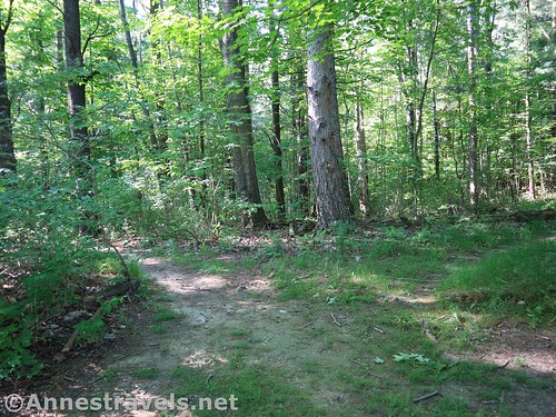
The trail climbs up the other side of the creek bottom and passes through the forest to a side trail well-marked as “Private Campsite Trail” with a right-pointing arrow. This means you want to turn left. My description makes it sound like there’s a campsite to the right (which is true), but in real life it looks like there’s a private campsite so you’d better turn right. Wrong! You want to turn left!

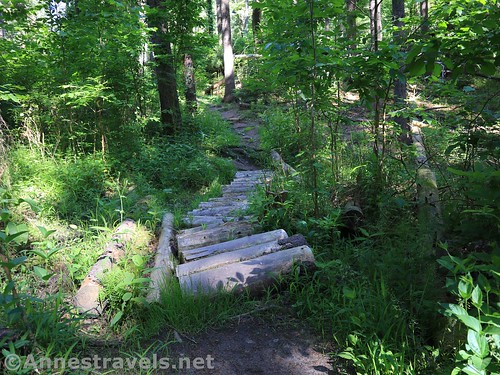
Stay on the trail as it gently descends to wind south along East Creek. The path has roots across it, so watch your footing. In very wet weather, the path is sometimes a little bit muddy, and on holiday weekends you can sometimes hear noise from the campground overhead – don’t worry, you’ll be past this soon. When you come to the trail up to Wolf Cabin (on the right), you want to turn left to cross over East Creek via the bridge. (Note: A slightly bedraggled sign on the tree says (among other things) Ridge Trail 0.15 mi..)
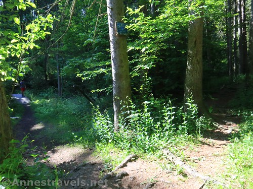
As soon as you cross the bridge, turn right. Orange blazes seem to go in all three directions.

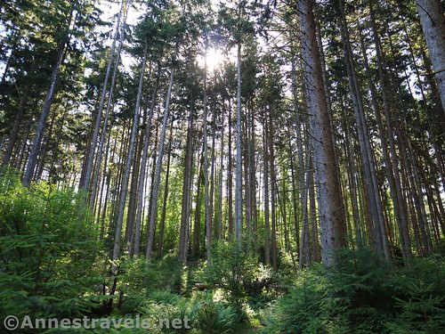
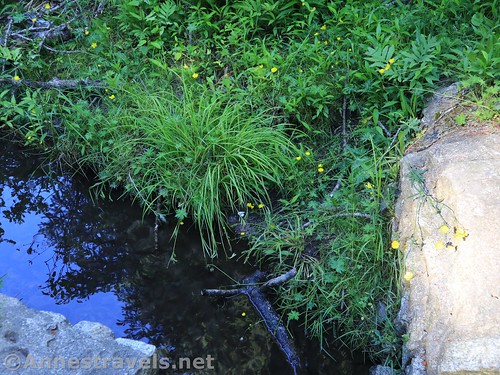
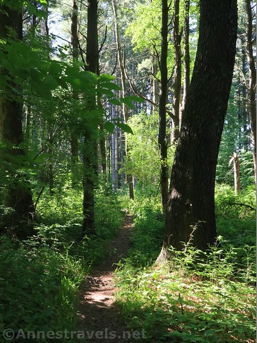
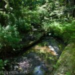
The path goes south along East Creek. This is one of my favorite places in Webster Park; the trail winds its way through cool glens of moss and ferns among the pine trees.

At 0.7 miles from the parking area, the trail splits right and left. The right trail crosses over East Creek; the left trail goes uphill. Turn left.

At the top of the hill, you’ll walk past a very, umm, old privy and then come in sight of a cabin (it’s called Cattaraugus). Before you get to the cabin (really about as soon as you walk out of the woods into the clearing) turn left down a trail through the forest.

Fairly quickly, you’ll come to a much more major trail going right and left (the sign is to the right). You want to turn left. This is the “Orange Trail”.

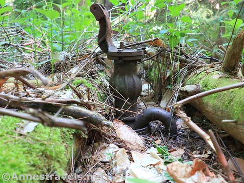
The Orange Trail goes north past a bench (which looks straight into the trees – very interesting I must say) and an old pump. You’ll also pass a four way trail junction that is signed for all kinds of things – including Wolf Cabin (left) and Holt Road (right). Continue straight on the Orange Trail.

At 1.1 miles from the trailhead, you’ll come to a place where the Orange Trail (which somewhere along the way lost a lot of its blazes) turns slightly toward the right. At the same time, a social trail descends to the left. You want to turn left down this trail.

At the bottom of the hill, turn right on the path that travels north (downstream) down East Creek. The path will eventually turn left to cross the creek via logs (or you can jump). Immediately after crossing the creek, turn right. You’re now back on the main path that you were on before – and before too long you’ll find the Private Campsite Trail again. Turn right to hike down to the bridge, up the other side, turn right on the trail beside the field, and so back to your vehicle.
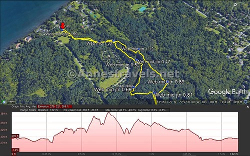
Round Trip Trail Length: 1.6 miles
Elevation gain: 161ft. (279ft. to 389ft.)
Facilities: None. The nearest restrooms are in the campground (if they’re open).
Fees: None
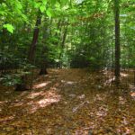
Trail Notes: One of the things that makes this a great summer hike is that it’s mostly shaded by the pine trees. It’s also beautiful in the winter (watch for ice on the trail) because the pines don’t lose their needles like most trees lose their leaves. The hike itself is only a little over a mile and a half, but it’s moderate due to the ups, downs, and roots along the trail. If you get lost, head generally west – you’ll run into a gravel road (or paved road) before too long. Take the gravel (or paved) road north and you’ll come to a paved road that will take you to Lake Road at the entrance to the campground road. Turn right and you’ll be back at the parking area before you know it.

Trail 
![]()
![]()
Road
Signs ![]()
![]()
![]()
Scenery ![]()
![]()
Would I go 100 miles out of my way for this? ![]()
![]()
![]()
![]()
Overall Rating: ![]()
![]()
GPS Coordinates for the Best Moderate Loop in Webster Park
Trailhead: 43.2579000°, -077.4586167° (N43° 15.474′ W77° 27.517′ / 43°15’28.4400″, -077°27’31.0200″) 242ft. (0.0)
Private Campsite Trail Junction: 43.2554833°, -077.4567500° (N43° 15.329′ W77° 27.405′ / 43°15’19.7400″, -077°27’24.3000″) 324ft. (0.23)
Trail Junction: 43.2529167°, -077.4555333° (N43° 15.175′ W77° 27.332′ / 43°15’10.5000″, -077°27’19.9200″) 341ft. (0.47)
Trail Junction: 43.2526333°, -077.4553667° (N43° 15.158′ W77° 27.322′ / 43°15’09.4800″, -077°27’19.3200″) 340ft. (0.52)
Trail Junction: 43.2515833°, -077.4572167° (N43° 15.095′ W77° 27.433′ / 43°15’05.7000″, -077°27’25.9800″) 363ft. (0.69)
Trail Junction: 43.2507000°, -077.4563667° (N43° 15.042′ W77° 27.382′ / 43°15’02.5200″, -077°27’22.9200″) 341ft. (0.81)
Trail Junction: 43.2508333°, -077.4550500° (N43° 15.050′ W77° 27.303′ / 43°15’03.0000″, -077°27’18.1800″) 361ft. (0.89)
Trail Junction: 43.2535167°, -077.4546833° (N43° 15.211′ W77° 27.281′ / 43°15’12.6600″, -077°27’16.8600″) 364ft. (1.12)
Return to main trail: 43.2549667°, -077.4557500° (N43° 15.298′ W77° 27.345′ / 43°15’17.8800″, -077°27’20.7000″) 348ft. (1.30)
End: 43.2576833°, -077.4586667° (N43° 15.461′ W77° 27.520′ / 43°15’27.6600″, -077°27’31.2000″) 367ft. (1.59)
The gpx file for The Best Moderate Loop in Webster Park can be downloaded – please note that this and the GPS Coordinates are for reference only and should not be used as a sole resource when hiking this trail.
Download GPX File size: 27.0 KB Downloaded 383 times
(Note: I do my best to ensure that all downloads, the webpage, etc. are virus-free and accurate; however, I cannot be held responsible for any damage that might result, including but not limited to loss of data, damages to hardware, harm to users, from use of files, information, etc. from this website. Thanks!)
Getting to Webster Park
If you’re familiar with Webster Park, you want to park in the small gravel parking area near the entrance to the Campground Road, across from the Kanatota Lodge.

From Rochester, take I-490 to NY-590N. Use the middle lane to get onto NY-590N. After 4.5 miles, take Exit 10B onto NY-104E toward Webster. You’ll fairly quickly cross the Irondequoit Bay Bridge. After 5 miles, immediately after crossing under the bridge for 5 Mile Line Road, take the exit for Holt Road onto the exit ramp. At the end of the ramp, turn left onto Holt Road. Continue about 3 miles to the (nearly) end of the road; turn left onto Lake Road. After 0.6 miles, turn left into the parking area – the parking area is across the road from the Kanatota Lodge.

From Wayne County, either take NY-104W to Holt Road or you can drive west on Lake Road to the parking area.
This Week’s Featured Product!
Check out this book for even more hikes in the Rochester, New York area and beyond. The trails are all in the Finger Lakes Region and central New York – most within day-trip distance of Rochester.
Pingback: The Best Hikes in Webster Park - Short, Easy Loop - Anne's Travels