

I don’t think I’ve ever seen anything quite like the Flattops Wilderness in northern Colorado. Ever. This pristine wilderness has some of the most grand views I’ve seen, and the top-of-the-world feeling is simply out of this world. I can try to compare it to “Christina’s World” (the painting by Andrew Wyeth), but that’s only part of the story. Here is also amazing cliffs, lakes, and alpine scenery, and, best of all, “The Causeway”, a rock bridge that for a few hundred feet is only 4 feet wide with 500 ft. drops on either side…very exciting! The views from here are also awesome, and it’s one of those hikes that I’d recommend to anyone I thought was up to the 6-10 miles RT treck! However, if you’re afraid of heights, this trail is still for you: there are ways of getting the awesome, Christina’s World-type views without having to cross the Causeway.
(Affiliate links are present on this page.)
The parking area is at the end of a dirt road that penetrates Routt National Forest. Although the road is dirt, it’s actually more gravel than dirt, and should be accessible even to those with low-clearance vehicles (at least when we were there…check at the ranger station in Yampa for current road conditions).

To get to the parking area, take CO 131 to the town of Yampa. This is a tiny town located about 30 miles south of Steamboat Springs (south on US 40 to CO 131) and 40 miles north of I-70 (north on CO 131). Turn into the town on Moffat Ave and drive straight past the post office. Then turn right onto Main St, and take the second left onto 2nd St. When this street ends, you should be able to see the ranger station. I took you here first because you can get water, maps, and other information here that is quite useful. From here, retrace your steps back to Moffat Ave and turn right. Continue on this road (CO Road 7) until it becomes Rcr7 after about 4 miles. After another 2 miles, the road will again switch names to US Forest Service Road 900. About 4.5 miles later, the road will change names again, this time to CO Hwy 159. You won’t actually be able to see most of these name changes, but if you’re following Google Maps that might be useful. Stay on CO Hwy 159 as you go around Yamcolo Reservoir (very pretty) and continue heading up—and up—and up on the last 6 miles or so to the end of the road. You will pass Upper Stillwater Reservoir. There are many small campsites in this area which you can camp in for a small fee. Some are actual campgrounds, while others just are campspots with a picnic table and fire ring. If you want to start your hike early in the morning, this is a great place to stay overnight. We spent the night in a campspot that overlooked Upper Stillwater Reservoir, which gave us a very pretty view.

The parking area is at the end of the road, near Stillwater Reservoir. There is a pretty useless signboard and primitive restrooms here. The trail begins to the left of the restrooms and the right of the signboards. This section of the trail was somewhat muddy when I hiked it, but it had rained the night before, so that might be part the reason. The trail skirts the reservoir for the first half mile. Enjoy the views of Stillwater Reservoir and the wildflowers that were blooming in this section in mid-August. After this half mile, there is a trail register and the trail splits. Actually, the trail splits just before this, and it really doesn’t matter which trail you take, as both of them take you to the trail register eventually. Sign the register book here, and then head up the trail to your right. Within the next mile, you will enter the Flattops Wilderness Area.
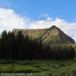
The trail from the signboard rolls up and down for the next mile or so through the forest and meadows. After you enter the Flattops Wilderness Area, you will get your first view of the Causeway, high above you straight across the meadow. It’s rather imposing looking, but don’t get discouraged: the trail will take you all the way to the top. From here, the trail begins to ascend fairly steeply. You are quite high here, over 10,000 ft. above sea level, so the air is quite a bit thinner than what most of us low-landers are used to. So, don’t be afraid to stop and catch your breath multiple times in this section.

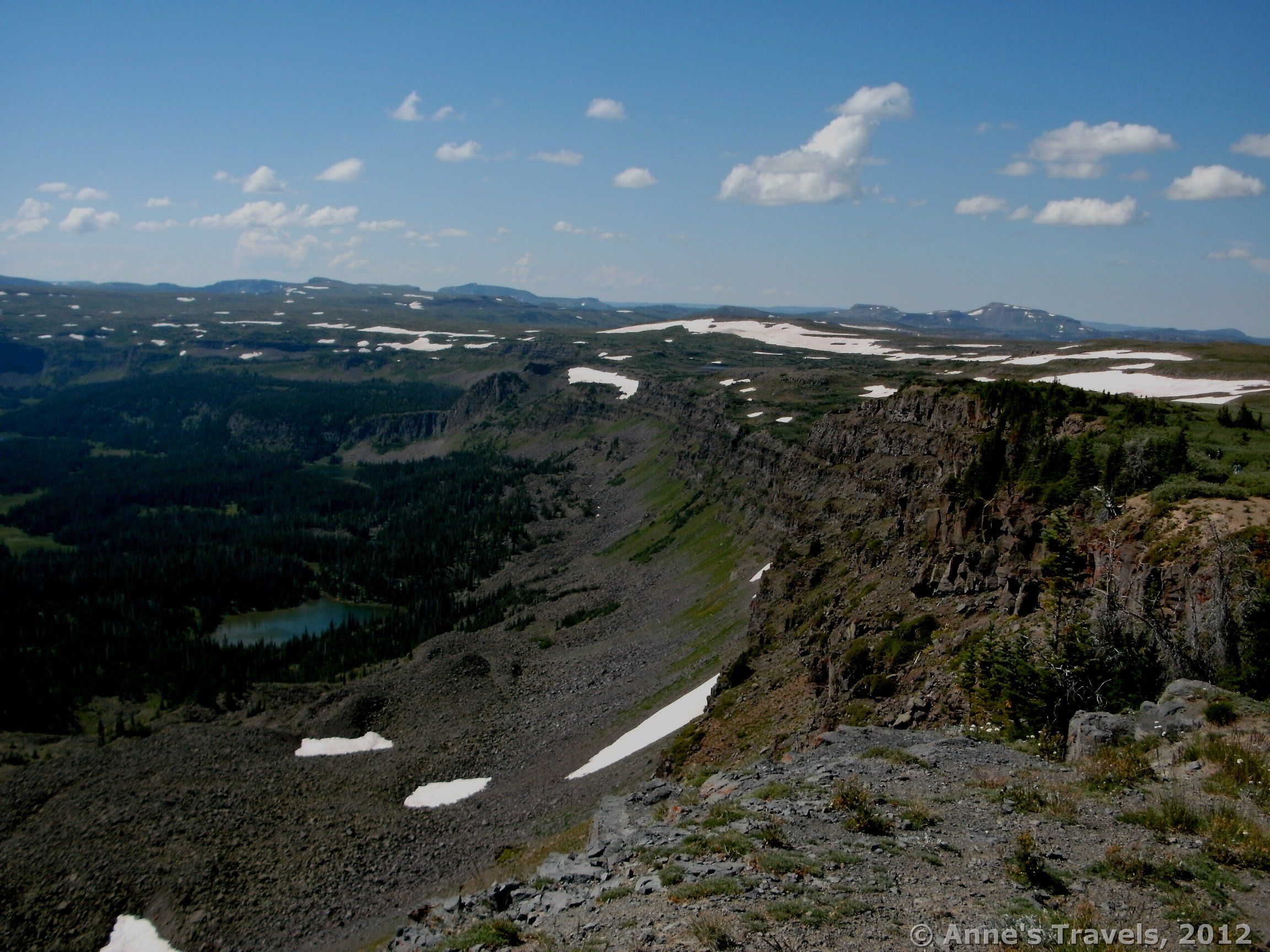
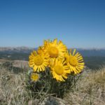
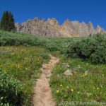
Finally, you will walk out above the treeline. The views here are outstanding, especially as you begin to switchback up the ridge. You will have been walking up, up, up and then suddenly come to a green cliff that rises up to a saddle, and the trail begins switchbacking up this. Take time to stop and look around: the views are really good, but they’ll be better from the top. There were also some really pretty wildflowers in this area in mid-August when we hiked the trail.
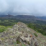
At last you will reach the top of the saddle, and the trail will sort of disappear. One trail appears to go across the saddle and down the other side, but this is not where you want to go. Over to the left in some bushes we discovered a sign that pointed to the left up the side of the saddle as the way to get to the Causeway. You are almost there—don’t give up now! Actually, by walking over to the other side of the saddle you can get some outstanding views down into the valley and across the way at more “flattops” area. We stopped here to have a snack before attempting the last ¼ mile up to the top of the Causeway.

It may only be ¼ mile to the top, but it’s definitely the steepest section you’ve encountered on the trail thus far. The trail itself (if you can call it a trail—it’s more of a route) steeply switchbacks its way up the side of the saddle. Take time to catch your breath—you’re almost 11,800 feet above sea level here, so for us low-landers, that’s quite a drop in oxygen. It’s doable, but take your time.
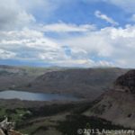
Then—at last—you reach the top. Here the views spread out in all directions; gorgeous views of the flattops area, the valleys surrounding the flattops and the huge sheer cliffs that divide the two. You can also see an amazing number of lakes—we counted over a dozen—from here. Also, back across the saddle we could see a sheep herder’s tent along with his horses and some of his sheep. It took us a while to figure out what it was because we were so far away. At any rate, the views from up here make the hike more than worth it. Take your time before returning or going across the narrow section of the Causeway.

If you want to cross the Causeway, continue along the top of the ridge you are now on down towards the rocky section. Here is a part of the ridge that is only 4-ft. wide with 500-ft. drops on either side of you. Yikes! No wonder they call it the Causeway! One person told us, “Just keep your eyes on your feet, don’t look around, and you’ll be fine.” He was right: if you keep your eyes on the rocks you’re walking on and around, it isn’t all that scary. I would have liked to have stopped in the middle and look around (for the view’s sake), but I was helping another member of my group across, and she had no intentions of stopping before she was safely on the other side. Ah, well. Maybe next time 🙂

At this point you have a decision to make: do you want to go back the way you came (6 miles RT) or would you like to see the Flattops at their finest, which I’ve said before makes me think of Christina’s World (10 miles RT). We had been debating, but as we looked over the terrain we’d have to cross to take the longer route, we knew we had to try it. Somehow we knew we’d be seeing some really nice top-of-the-world-tundra, and that in itself made us willing to go the extra 4 miles. Also, one member of our group (who can’t stand heights) said she’d rather walk 4 more miles that have to cross the Causeway again.

So, take your choice. If you want the shorter hike, return the way you came. If not, continue along the trail that leads down off of the Causeway and into some low-lying bushes. From here on out across the Flattops, the trail is there but a little vague. In this section it would be difficult to lose it, unless you walked off of the trail more than about 5 feet, at which point the trail becomes almost invisible. It does become more vague as you walk along, but it is easy enough to follow and enough people have walked it that even when you can’t see it, you can still figure out which way to go. Don’t worry too much about getting lost.
After going through the bushes, the trail (which is dirt, sometimes one track, sometimes two, occasionally three tracks) continues to descend downhill, flattens out, and then ascends a small hill. It is after this that the Christina’s World-type views begin to appear. Mile after mile of waving grass, occasionally interrupted by some rocks or low-lying boulders. To me, it was one of the most beautiful and awe-inspiring things I saw on the whole trip. I’m sure not everyone loves the tundra as much as I do, but to me, it was amazing. Occasionally you will come upon a small pond in a depression in the grass, or you’ll be able to see out to where the Flattops end and the valley begins. Gorgeous! If you want to see this area, but don’t want to cross the Causeway, you’ll have to follow my directions backwards from the end of the post to here.

The trail wanders its way across the Flattops, then takes a sharp turn to the left. This is where the trail begins to be a bit vague. By this point for us, the sky had clouded over, so the views could have been better from this point on. Thankfully, though, it didn’t rain. Colorado has a habit of having thunderstorms every afternoon (where it will most certainly hail, according to my limited experience), but thankfully these held off until we were back at the parking area. Anyhow, be aware that this is an issue. We continued to follow the track until we came to a signpost at a trail junction. Supposedly, the trail you are on keeps going straight across, but very few people must take this trail, since it looked like a non-trodden grassy hillside to me. Turn left down the new trail and head up over the hill.

You will fairly soon come to another sign post (which against the clouds looked like some kind of grave with a cross on it). Keep walking straight past this signpost. The trail from here will descend down several switchbacks to the valley below. By the time we got to the bottom, the sun had come out again (hurray!) and the trail took us through a forest. We crossed one stream and passed a couple of lakes before the trail brought us back out to the trail register where you signed in earlier. From here, follow the trail straight (sort of right) back by the reservoir and back to the parking area. I’m going to guess that it’s between 3.5 and 4 miles across the Flattops and then 3 or 2.5 miles through the forest back to the trail register.

No matter if you decide to take the longer trail or not, the views from the Causeway make this trail one of the grandest I’ve run across in a long time. I highly recommend that others take this amazing hike. Actually, we saw very few people while we were there: a few couples, and a few backpackers. The area only gets about 500 visitors a year.
(You can read about my return to the Causeway – with GPS coordinates, more accurate trail mileages, and other adventures, here.)
Round Trip Trail Length: 6-10 miles
Facilities: Primitive restroom and signs at trailhead, trail register part way up trail
Fees: None
Trail 
![]()
![]()
Road ![]()
Signs ![]()
![]()
Scenery
Would I go 100 miles out of my way for this?
Overall Rating: ![]()

This Week’s Featured Product!
When I wrote this book about Colorado, I included several hikes in the Flat Tops Wilderness. There’s also hikes in many other parks and oh, so many views! Check it out on Amazon.

11 responses to “Highlands of Colorado: The Causeway”
WONDERFUL Post.thanks for share..more wait ..
A round of applause for your blog.Really thank you! Really Cool.
I like it! Your post is really good providing good information. I liked it and enjoyed reading it. Keep sharing such important posts. I am very much pleased with the contents you have mentioned. I wanted to thank you for this great article. I enjoyed every little bit part of it and I will be waiting for the new updates. I really appreciated this post. Just want to say thank you for the information you have shared. Just continue writing this kind of post. Thanks.
Great Site! I wanted to ask if I could quote a portion of your posts and use a handful of items for a school assignment. Please let me know whether or not that would be fine. Thanks
Hi Stamp,
Feel free to quote the website with proper citation.
Thanks!
Anne
[…] The views from here are amazing, but better is to come. Actually, the rock bridge reminds me of The Causeway in Colorado, except that the views are extremely […]
[…] exhilarating (I’d call it the most dangerous trail I’ve ever done (yes, more dangerous than the Causeway)), but because for strong-hearted hikers it offered some of the best views I’ve ever seen of Zion […]
[…] Hiking across the Flat Tops through “Christina’s World” […]
[…] day by hiking around the Devil’s Causeway Area in the eastern section of the wilderness area. I already detailed that general hike in another post, but we did enough differently that I thought I’d write another post. The highlight of this […]
[…] The Causeway, Flat Tops Wilderness Area, CO (And it came out on top on a second trip, too!) […]
[…] The Causeway, Flat Tops Wilderness, Colorado […]