
If there’s one easier hike in Glacier National Park to blow your view-junkie mind, try the North Shore Josephine Lake Trail to Grinnell Lake. The trail is mostly flat and passes through forests and open views up toward Grinnell Glacier and peaks along the Continental Divide. The trail to Grinnell Lake also features two waterfalls (Hidden Falls along the trail – the suspension bridge nearby is fun! – and another tumbling down the cliff into Grinnell Lake). The only downside is that you will be sharing the trail with a fair number of other people since the beginning of the trail is shared with the extremely popular Grinnell Glacier Trail and the later part of the trail is serviced by a shuttle boat from the Many Glacier Hotel. Still, the views make it worth the hike!
Quick Stats
(Affiliate links are present on this page.)

I’ve started this hike from two different places – the Many Glacier Hotel Parking Area and the Grinnell Glacier Trailhead. Either will work just fine, though the GPS coordinates in this guide are from the Grinnell Glacier Trailhead.

If coming from the Many Glacier Hotel, head down to Swiftcurrent Lake and turn left on the Swiftcurrent Nature Trail that heads south along the lakeshore. After about 0.7 miles, you’ll arrive at the trail junction for the South Shore Josephine Lake Trail. Turn right – the south shore is wooded and a very uninteresting experience. Pass by the boat dock and continue another 0.2 miles to the trail junction to turn left toward Grinnell Lake and Grinnell Glacier.

Alternately (as my map below shows), from the Grinnell Glacier Trailhead, take the wheelchair accessible Swiftcurrent Nature Trail, following the signs for Grinnell Glacier and Grinnell Lake. After 0.7 miles, turn right, following signs for Grinnell Lake and Grinnell Glacier (the boat dock across Swiftcurrent Lake is to the left).

Continue for either trailhead as follows: After about 0.2 miles, a trail will go off on left down to the boat dock at Lake Josephine. Turn right to stay on the North Shore Josephine Lake Trail toward Grinnell Glacier.

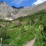
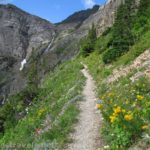
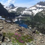
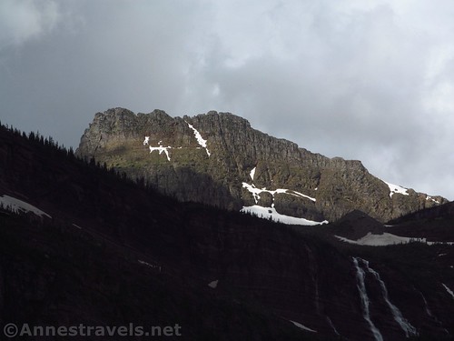
From here, the views begin to open up toward Mount Grinnell, the Angel Wing, Mount Gould, the Grinnell and Salamander Glaciers, and the peaks along the Continental Divide. There are also some good views across Lake Josephine to Allen Mountain. It’s all spectacular!
Two trail junctions lead up to Grinnell Glacier; one at 1.8 miles and the second at 2.2 miles from the Grinnell Glacier Trailhead (add 0.2 from the Many Glacier Hotel). Keep straight (left) on lake-level toward Grinnell Lake at these junctions.

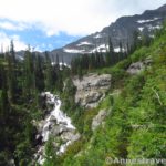
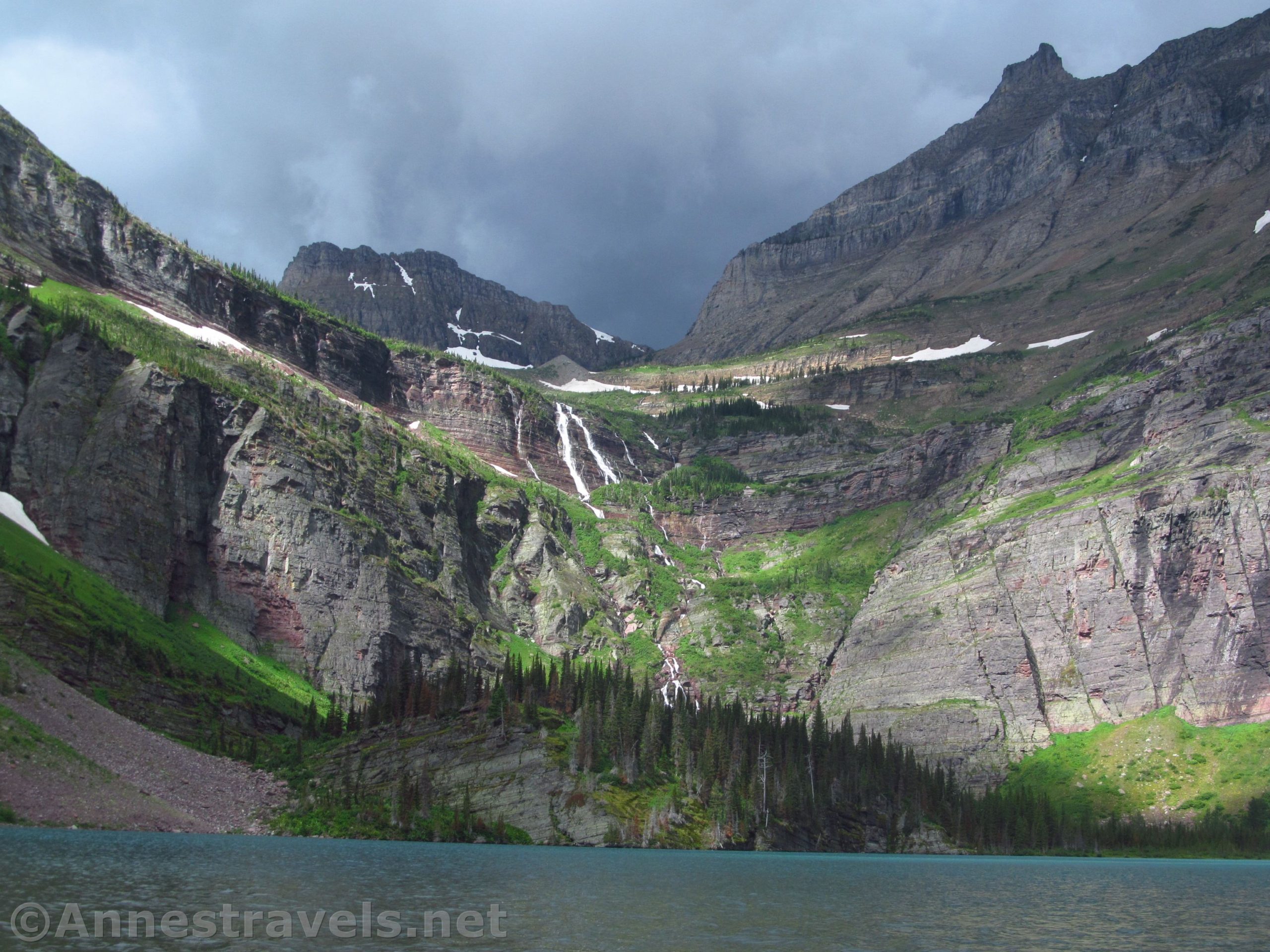
The trail eventually turns left to cross Grinnell Creek (it may be a slightly off-color – this is from the sediment carried down from the glaciers). Views from the bridge are very impressive.

Cross a swampy area, then come to a well-used trail junction at mile 2.5. The boat dock turns left, but you want to turn right toward Grinnell Lake. The trail passes through the forest without much in the way of views – but you do get a pit toilet 0.8 miles from the trail junction!

Continue along the forested trail to the turnoff for Hidden Falls at mile 3.45. This is a very worthy (if steep) side-trek that I took on the way back. It’s about 0.1 miles up to the falls and another 0.1 back. It can be difficult to see the falls, but I guess that’s why they’re called “hidden”.

The trail next crosses over the creek via a swinging bridge. I personally love swinging bridges, so this alone makes the trail worth something to me! There is a one hiker limit, so occasionally there can be a line of hikers (at both ends) waiting for their turn to cross. But even as you’re swinging, be sure to look down into the creek – the pebbles on the bottom are beautiful colors.

The first time I hiked the trail, from here the path followed boardwalks and a path through the swamp along the creek. Apparently it was washed out one too many times (or maybe a landslide occurred – it certainly looked like it), because now the trail hugs the side of the mountain quite a way above the creek. The Peigan Pass Trail goes off to the left at mile 3.6 (technically you can hike from here to the Going-to-the-Sun Road) before the trail descends back down to creek-level and then comes out at Grinnell Lake at mile 3.8.

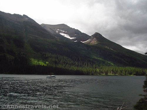
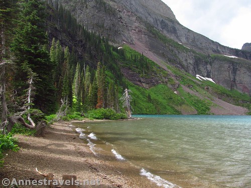
There are ebbs and flows of people at Grinnell Lake. On a nice day, it’s likely there will be people at least at the initial beach most of the time. On a cloudy day – like we had – we had one of the side-beaches to ourselves, then people would come in a wave from a boat arriving at the dock, then the people would trickle back into the forest to return to the boat dock before another wave arrived.

Overall, though, Grinnell Lake is spectacular, even on a cloudy day. Grinnell Falls is beautiful and the peaks above (mostly the Garden Wall above the Salamander Glacier) are spectacular. It was a pity it was such a cloudy day, but hey, views under the clouds are better than no views at all!

We took some of the social trails on the left to a slightly more secluded beach. The rain earlier had left everything more or less soaked, but we found an old board, turned it over, and it was dry enough to sit on during lunch. On my first visit, some of us had walked and scrambled all the way to the other end of the lake. Given how wet the bushes were, the fact that we had done 14 miles the day before up to the top of Cracker Lake, and the fact that we were saving our energy for 17 miles the next day up to the Swiftcurrent Lookout (not to mention the current look of the sky), we decided to leave the other end of the lake for another visit and turned around to go back.
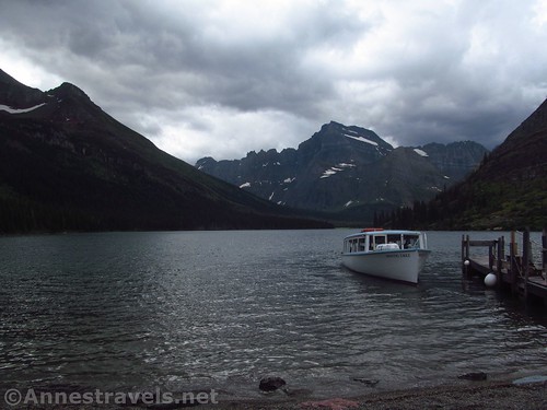
On our way back, the sky let loose in a few raindrops and plenty of snow and hail. My group members weren’t all together at that point, so some of them were caught in the forest (they stayed pretty dry) and others were out along the open slopes on the northern shore of Lake Josephine (they were not what I would call dry when we returned to the parking area). I and a few others were close enough to the boat dock that we ran to the shelter near the dock – much better to stay dry, even if the stone shelter was deceptively frigid!

Also on the way back, I was caught behind a deer eating in the middle of the trail (everyone is so used to being warned about bears that they freak out at white-tailed deer). Two of my group members also saw a bear (yikes!) But we got back to the van all in one piece, so I guess it all turned out fine!

Round Trip Trail Length: 8.2 per my GPS. The NPS clocks it at about 7.2.
Elevation Gain: 1,105ft. (4,882ft. near Swiftcurrent Lake to 5,012ft. at Hidden Falls)
Facilities: Picnic area and restrooms at the Grinnell Glacier Parking Area; primitive restroom at about mile 3.3.
Fees: $35/vehicle/week. National Park & Federal Recreational Lands Passes and Glacier Annual Passes are honored.
Trail Notes: You can cut 0.7 miles (each way) off the hike by taking the boat from the Many Glacier Hotel across Swiftcurrent Lake. Alternatively, cut 2.5 miles (each way) off of the hike by taking the boat across Swiftcurrent Lake and Lake Josephine. (Click here for current boat fees.) Personally, I prefer to take my time on the North Shore Josephine Lake Trail and enjoy the views!
Trail 
![]()
![]()
Road ![]()
Signs
Scenery
Would I go 100 miles out of my way for this?
Overall Rating: 

GPS Coordinates for Grinnell Lake
Trailhead: 48.7969500°, -113.6684000° (N48° 47.817′ W113° 40.104′ / 48°47’49.0200″, -113°40’06.2400″) (5,067ft.) (0.0) (end 8.20)
Swiftcurrent Lake Dock Junction: 48.7892000°, -113.6666833° (N48° 47.352′ W113° 40.001′ / 48°47’21.1200″, -113°40’00.0600″) (0.71)
Trail Junction: 48.7888500°, -113.6664333° (N48° 47.331′ W113° 39.986′ / 48°47’19.8600″, -113°39’59.1600″) (4,906ft.) (0.75)
Boat Trail Junction: 48.7878667°, -113.6699667° (N48° 47.272′ W113° 40.198′ / 48°47’16.3200″, -113°40’11.8800″) (4,905ft.) (0.98)

Grinnell Glacier Junction: 48.7805167°, -113.6803667° (N48° 46.831′ W113° 40.822′ / 48°46’49.8600″, -113°40’49.3200″) (4,923ft.) (1.81)
Grinnell Glacier Junction #2: 48.7763333°, -113.6853333° (N48° 46.580′ W113° 41.120′ / 48°46’34.8000″, -113°41’07.2000″) (4,892ft.) (2.21)
Lake Josephine Boat Dock: 48.7740500°, -113.6831500° (N48° 46.443′ W113° 40.989′ / 48°46’26.5800″, -113°40’59.3400″) (4,894ft.) (2.47)

Toilets: 48.7680667°, -113.6955500° (N48° 46.084′ W113° 41.733′ / 48°46’05.0400″, -113°41’43.9800″) (4,934ft.) (3.30)
Hidden Falls Trail Junction: 48.7669000°, -113.6955333° (N48° 46.014′ W113° 41.732′ / 48°46’00.8400″, -113°41’43.9200″) (4,950ft.) (3.45) (return 4.12)
Piegan Pass Trail Junction: 48.7654833°, -113.6986667° (N48° 45.929′ W113° 41.920′ / 48°45’55.7400″, -113°41’55.2000″) (4,956ft.) (3.66)

Grinnell Lake: 48.7650667°, -113.7009333° (N48° 45.904′ W113° 42.056′ / 48°45’54.2400″, -113°42’03.3600″) (4,929f.) (3.79)
Hidden Falls: 48.7663500°, -113.6949000° (N48° 45.981′ W113° 41.694′ / 48°45’58.8600″, -113°41’41.6400″) (5,012ft.) (4.23)
Shelter: 48.7738500°, -113.6864667° (N48° 46.431′ W113° 41.188′ / 48°46’25.8600″, -113°41’11.2800″) (4,880ft.) (5.30)
Boat Dock: 48.7876667°, -113.6701333° (N48° 47.260′ W113° 40.208′ / 48°47’15.6000″, -113°40’12.4800″) (4,880ft.) (7.3)

The gpx file for Grinnell Lake can be downloaded – please note that this and the GPS Coordinates are for reference only and should not be used as a sole resource when hiking this trail.
Download GPX File size: 149.5 KB Downloaded 462 times
(Note: I do my best to ensure that all downloads, the webpage, etc. are virus-free and accurate; however, I cannot be held responsible for any damage that might result, including but not limited to loss of data, damages to hardware, harm to users, from use of files, information, etc. from this website. Thanks!)

Getting to the Swiftcurrent Trailhead
From St. Mary, drive north on US-89N for 8.5 miles. Turn left in Babb, following signs for Many Glacier. After 7.5 miles, enter Glacier National Park and the road will improve. Drive another 4.5 miles; turn left into the parking area for Grinnell Glacier. Note that the parking area is usually full by 9am and parking in non-designated places is prohibited.
From the north, drive about 10 miles south of the Canadian border to the town of Babb. Turn right, following the sign for Many Glacier, and follow the directions above to the trailhead.
Road note: As of summer 2019, the road to Many Glacier is one of the worst I’ve seen as a thoroughfare into a national park. It’s literally riddled with potholes. So slow down and use care; the people around you will be swerving to try and avoid the gaping holes in the road.

This Week’s Featured Product!
Do you want to know what’s the best of the best in Glacier National Park? Check out this book full of lists – the best waterfalls, the best hikes, and so much more.