

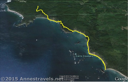
I wanted a beach walk. And I wanted sea stacks. And it had to be long – at least, longer than a mile or two each way. And since I was at Mt. Baker, Olympic National Park wasn’t too far out of the way, right?
Quick Stats
(Affiliate links are present on this page.)
So I looked at all the beaches in Olympic, studying pictures, trail descriptions, and regulations, and decided that Third Beach would be just about right. There weren’t any stream crossings (at least, you never had to get your feet wet), we could make the trail as long as we wanted, there were sea stacks (and a waterfall coming down a cliff), and we didn’t have to get a special permit from the Native American reservation…what could be better, right? (Afterward…maybe a little sand?)
Anyway, we drove in from the other side of Olympic early one morning in mid-August. The weather was pretty cloudy, but I guess we could expect that on the coast. We figured we’d hit the beach about high tide, so we would have about 12 hours for our hike without high tide hitting again. (This would lessen the chance of us getting caught by the tide. We still almost got caught ayway, but more on that later.)

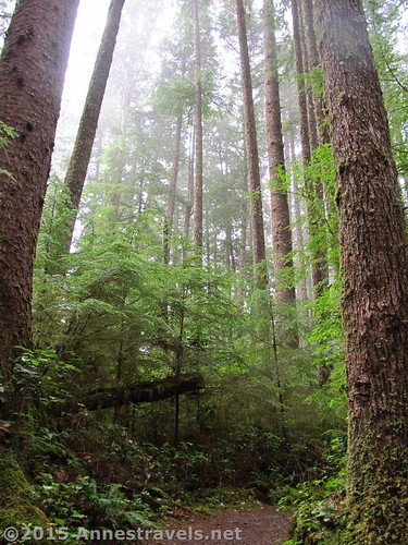
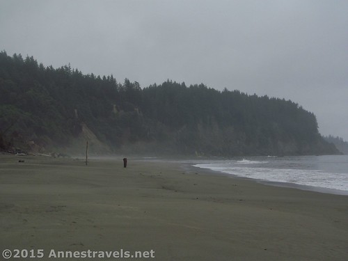
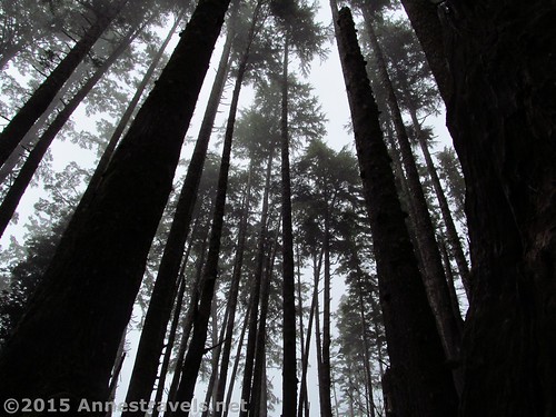
The first part of the trail is through a rain forest. It winds, quite flat, for about a mile through the ferns, moss, and lush greenery, then suddenly begins a steep descent to the beach, half a mile away. I think some of my group members weren’t quite ready for such a long walk to the beach – usually when we’re in Olympic, we visit Ruby Beach or Rialto Beach, with the ocean less than 0.25 miles from the parking area. Still, it was an easy walk, so it wasn’t too bad.
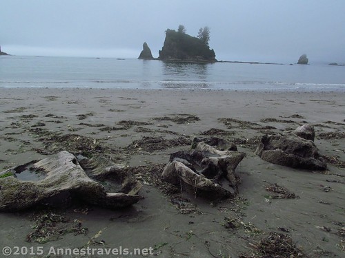
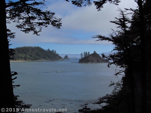
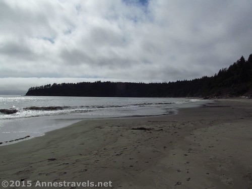
Getting from the trail to the beach can be a little complicated; you may have to scramble over a few logs or through some beach grass. We came out right next to the stream, a sight I’m not used to on Eastern beaches. It was so cool to see the water flowing intricately through the sand into the salty ocean and know that its path would be different after the next tide.
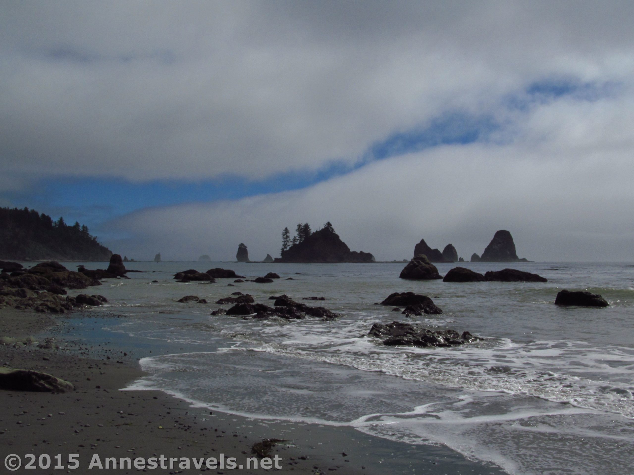
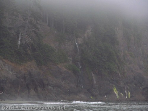
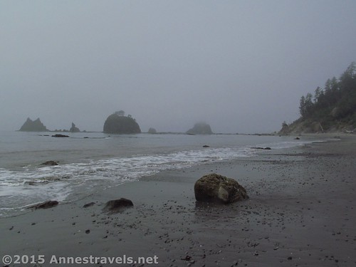
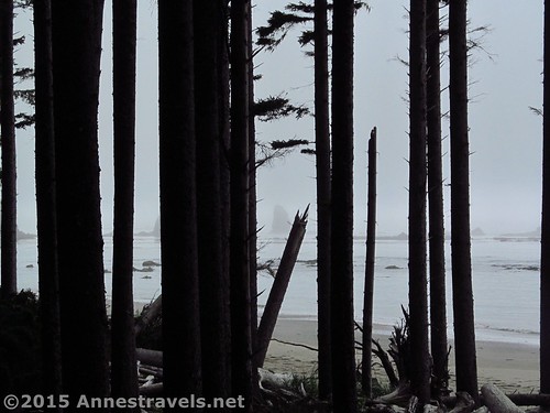
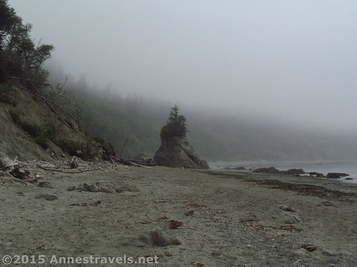
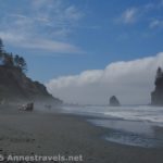
We turned left down the beach for almost another mile. Just before reaching the cliff and the serf at the end of the beach, you can see a waterfall tumbling down the cliff face into the ocean. Cool!
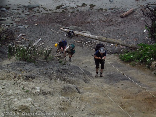
Look on your left up into the woods and you’ll see a red and black sign. A rope hangs down the side of a sandy bank. You’ll need to climb this seemingly impossible bank. It’s nowhere near as bad as it looks (thankfully – if it was, we couldn’t have done it!) and you may not even need to use the rope.
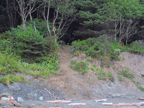
After climbing the bank, the muddy trail immediately enters the rain forest to climb a kind of ladder. Some of us thought this was great fun, though it got a little tricky when some of the rungs of the ladder were broken. Again, though, it was doable and we all got though ok.
For the next 1.25 miles, the trail winds across the headland through the rainforest. The trail is often muddy, with a variety of bridges and stepping stones (and stepping logs) to help get you over the worst of the mud. I don’t want to paint an impossible picture, but it was so wilderness – which I loved!
The entire way, we were going against the crowds. Apparently this route is mostly taken by backpackers – so we were early enough in the morning to be going against the crowd coming back from their overnight stays. Then, on the way back, the day hikers were finally out, as were the people coming in for the night! We found ways to pass and both sides gave cheerful greetings as we passed.
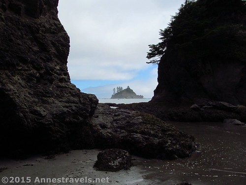
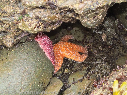
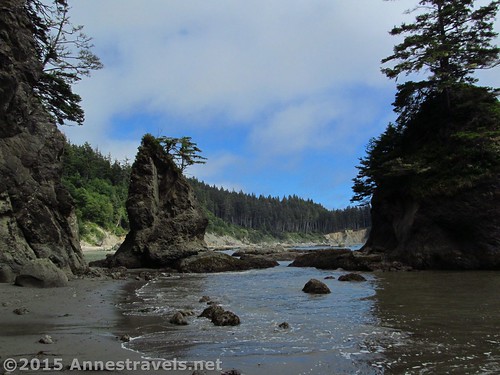
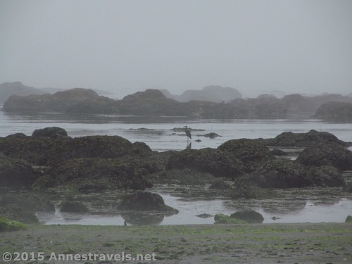
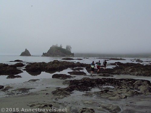
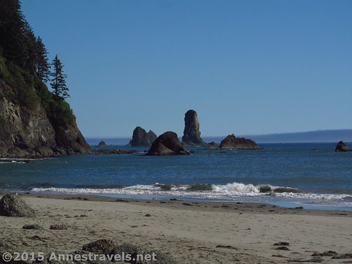
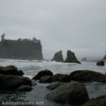
Finally, the trail descended back to the beach. This decent was somewhat exciting, as there is no rope and the trails was quite muddy. Still, no one slipped, and we couldn’t wait when we stepped out onto the stone beach again – ahead of us were tide pools! There were better ones later, but these had a variety of sea life, including a few sea stars. We could also walk right round in the sea stacks, which was fun.
We stopped here for lunch (finally, a place to sit down!) Peanut butter and jelly consumed, we continued down the beach.
Only a mile later, we came to another red and black sign. This scramble up a latter really does require a rope. We waited for some backpackers descend, then tried it for ourselves. Although more difficult, it was also more fun 🙂
This trail over the headland was a lot shorter, only 0.3 miles, so before too long we were down on the beach again (the trail down wasn’t bad at all). After this, it was a very nice beach walk, mostly over stones with some sections of sand.
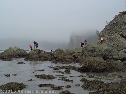
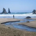
At 4.9 miles, on the other side of a sea stack, we ran across more tide pools. Scrambling on the slippery rocks, we counted 80 sea stars (not to mention the kelp and other sea life)!
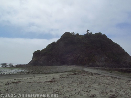
We finally came to Strawberry Point at 5.9 miles. It was getting late enough in the day (and we really didn’t want to hike too much further because we’d have to walk all the way back), so we decided to turn around here.
It turned out to be a good decision. Approaching the ascent back up to the headland, we nearly didn’t make it around the sea stacks with the tide coming in. Ten minutes later, and we’d have been racing the waves; 20 minutes and we’d have been using the overland scramble over the sea stack!
The sun started to peek out about this point, so we spent some time at the bottom of the trail, enjoying the sea stacks, taking pictures and (as some of the younger ones were doing) tempting the incoming tide to get our feet wet (only one person got really wet shoes – and I was taking a picture of him at the time, so he’s really not to blame!)

By this time, we were meeting tonight’s backpackers as well as more day hikers. Again, we were going against the crowd, but I’d say we met fewer people coming back than going out.
About the time we finally scrambled down the bank back on Third Beach, the sun decided to appear. Wow! I wish we’d had more sun when we were closer to the sea stacks, but it was still pretty neat and showed us that no matter how cool the mist is (and it’s amazing) the sun is even better!

From here, it was just the walk down Third Beach, then back to the parking area. The trail become more and more crowded the closer we got to the trail, then to the parking area. So for solitude, it’s great after you ascend the first headland!
Round Trip Trail Length:11.7 miles
Highest Elevation: 325ft. (parking area)
Lowest Elevation: Sea level (or -8ft., whichever you prefer)
Elevation Change: 325ft. – the overall elevation is quite a bit more due to climbing the headlands.
Fees: $15 to enter Olympic National Park, valid 7 days. America the Beautiful (Interagency), Senior (Golden Age), Access (Golden Access), Volunteer, Military, and Olympic National Park Annual Passes also accepted. Discovery Pass and Northwest Forest Service Passes NOT accepted.
Trail 
![]()
![]()
![]()
Road ![]()
Signs ![]()
![]()
![]()
Scenery
Would I go 100 miles out of my way for this?
Overall Rating: 
![]()
Key GPS Coordinates for Third Beach
Parking area: 47.89058N / -124.59940W (47° 53′ 26.0874″ / -124° 35′ 57.84″) (325ft.)
Trail beginning: 47.89061N / -124.59921W (47° 53′ 26.196″ / -124° 35′ 57.1554″) (317ft.) (ended 11.7)
Third Beach: 47.87783N / -124.58782W (47° 52′ 40.188″ / -124° 35′ 16.1514″) (23 ft.) (1.4)
Headland Trail Junction #1: 47.87515N / -124.57983W (47° 52′ 30.5394″ / -124° 34′ 47.388″) (-8ft.) (1.9)
Top of Ladder: 47.87539N / -124.57913W (47° 52′ 31.404″ / -124° 34′ 44.868″) (99ft.) (2.0)
Headland Trail Junction #2: 47.86747N / -124.56705W (47° 52′ 2.8914″ / -124° 34′ 1.3794″) (9ft.) (3.3)
Tide Pools #1: 47.86704N / -124.56799W (47° 52′ 1.344″ / -124° 34′ 4.7634″) (-3ft.) (3.3)
Headland Trail Junction #3: 47.86341N / -124.55824W (47° 51′ 48.276″ / -124° 33′ 29.6634″) (11ft.) (4.2)
Headland Trail Junction #4: 47.86024N / -124.55775W (47° 51′ 36.8634″ / -124° 33′ 27.8994″) (19ft.) (4.5)
Overland Trail #2 Meets Beach: 47.86024N / -124.55775W (47° 51′ 36.8634″ / -124° 33′ 27.8994″) (19ft.) (4.5)
Tide Pools #2: 47.85616N / -124.55814W (47° 51′ 22.176″ / -124° 33′ 29.3034″) (10ft.) (4.9)
Strawberry Point: 47.84594N / -124.55053W (47° 50′ 45.3834″ / -124° 33′ 1.9074″) (-2ft.) (5.9)
The gpx file for Third Beach can be downloaded – please note that this and the GPS Coordinates are for reference only and should not be used as a sole resource when hiking this trail.
Third Beach Hike GPX File size: 227.8 KB Downloaded 662 times
(Note: I do my best to ensure that all downloads, the webpage, etc. are virus-free and accurate; however, I cannot be held responsible for any damage that might result, including but not limited to loss of data, damages to hardware, harm to users, from use of files, information, etc. from this website. Thanks!)
Getting to Third Beach
From Port Angels, WA drive 53 miles west on US-101. Turn right onto WA-110 W / La Push Road and drive 11.5 miles. The signed parking area for Third Beach will be on the right.
From Aberdeen, WA drive 105 miles on US-101 N. Turn left onto WA-110 W / La Push Road and drive 11.5 miles. The signed parking area for Third Beach will be on the right.
Zoom map out to browse nearby hikes & places of interest
This Week’s Featured Product!
Hiking on the Olympic Peninsula? This book is one of the more comprehensive guides for the dayhiker, covering lakes, mountains, ridge walks, and beaches. There are also several sections covering Olympic National Park.

8 responses to “Hiking Third Beach to Strawberry Point: Rain Forests and Sea Stacks”
[…] Ruby Beach in Olympic National Park very early in the morning. We hadn’t slept nearby – after hiking Third Beach the day before, all we wanted to do was find a place for supper and then go to bed – but being […]
[…] Third Beach to Strawberry Point. Ever scrambled up a steep slope and wished you had a rope to help you climb up? Along the Pacific Coast in Olympic National Park, the park service has conveniently left the ropes there for you so you can cross headlands in safety if not comfort. The section from Third Beach to Strawberry Point has two such headlands, which might or might not be scalable without the rope, along with ladders, tree trunks, and other more “natural” aids to help you navigate the steep slopes of the headlands and the deep mud along the tops of the highlands. Is there a reason this one came out near the top of our “favorites” list the last time we hiked it? […]
[…] rain forest near Third Beach, Olympic National Park, […]
[…] Third Beach to Strawberry Point, Olympic National Park, Washington. […]
[…] Third Beach to Strawberry Point, Olympic National Park, Washington […]
[…] south of Third Beach, Olympic National Park, […]
[…] Hiking Third Beach to Strawberry Point, Olympic National Park, Washington. Beaches. Sea stacks. Tide Pools. Rain forests. Need I say more? 11.7 miles with 325 ft. elevation gain. […]
[…] get between the North Cascades (Hidden Lake, to be exact) and Olympic National Park (specifically, Third Beach), so this ferry was very much on the way, shortening the trip by several hours and the fee was […]