

I had two goals (among many lesser goals) for my most recent adventure: 1) Visit White Pocket in Arizona, and 2) Hike all the trails I’ve never taken in Bryce Canyon National Park. Both were ambitious, but both were also great fun! In between and around these two goals, we squeezed through some of the narrowest slot canyons I’ve ever explored, finished hiking every trail in Petrified Forest National Park, hiked a trail harder than Lava Falls into the Grand Canyon, visited the gorgeous Deadhorse State Park for the first time, found beautiful trails in Zion and Capitol Reef, explored the Moon and Mars, and much more!

We started with Petrified Forest National Park. Somehow, in all my visits in the last three years, I missed the Painted Desert Rim Trail and the Tawa Trail. Thankfully, they’re easily accessible from the highway and can be hiked together.

While we were there, we also visited the Blue Mesa Overlook…

…and hiked into the South Wilderness Unit of the park (which has no trails, and the ranger I spoke to didn’t know how to access – I guess most people don’t go there).

From Petrified Forest, we drove up to Page, where we stopped to eat supper at the Dam Overlook (only there weren’t any picnic tables, so we ended up eating at our camping spot).

Then we went up past Big Water to the unmarked trailhead for Sidestep Canyon. En route, we ended up exploring Rainbow Valley/Colorful Canyon, which (to me) was more exciting and less colorful than the more-lauded Sidestep Canyon.

The next day, we drove down to a hike I’ve wanted to do for a long time: The South Canyon Route to Vasey’s Paradise (a waterfall along the Colorado River in the depths of the Grand Canyon). It sounded like a slightly rough 6-mile hike. But within a quarter mile of the top, we realized this was no afternoon stroll. In fact, I’d call it harder than the Lava Falls Route. But we dropped over rocks, scrambled down rocky chutes, scratched our heads as to where the trail went, and finally made it to the bottom of South Canyon – only to find more rock scrambling, dryfall bypasses, and more excitement! We finally gave it up (we both really wanted to get back before dark) a mile or so from the waterfall. I’ll do it again – despite being almost impossible, it’s a gorgeous hike – but I’ll give myself a whole lot more time to attempt it!

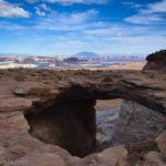
We knew we wanted to position ourselves to pick up our rental jeep in Page the next evening, so we checked out the roads we’d be driving by taking the trek out to Double Barrel Arch. It’s by no means famous, but pretty neat and an easy hike, all the same.

Back in Page, I tried to figure out how the Shell Cave looked like the pictures on the internet. Answer? It’s called Wide Angle on your phone… which makes the cave about 10 times deeper than it is in reality. Still some fun things to see in the area while puzzling out how to get those photos!


We picked up our jeep from the rental company (shout out to Jeep B&B/White Pocket Jeep Rental, who were awesome!) and headed out to White Pocket (which is known as the non-permit alternative to the Wave). Let me tell you, those last 15 miles or so of the road shouldn’t be attempted with 2WD. They’re all sand. But it was great fun in a jeep. We cowboy camped (complete with frost on our sleeping bags in the morning), then got up early to catch golden hour at White Pocket.

Most people who visit rent a jeep for a day, drive out, spend a couple of hours around noon (aka not the best light), and then have to return the jeep. Because we paid for early pickup, we had the place almost completely to ourselves for several hours before the hordes (aka 5-10 other groups) arrived. Worth it? Yes!!

After all that excitement, we figured we should take a day to recover. AKA, we wanted to take a few short hikes instead of a long and difficult one, and I figured all the places I see on Instagram would be the perfect adventures for a rest day. The Moqui Sand Caves near Kanab were really neat.

Then we got distracted by a place marked on the map as Elkheart Cliff Slot Canyon. It was fun at first – then it became too technical for us! So we had to bypass the last section, and maybe it wasn’t quite gentle enough for a rest day. But still beautiful.

Late in the afternoon, we pulled into the parking area for Belly of the Dragon. When the highway was constructed, a tunnel was to carry rainwater under the road. It’s become quite a destination. We continued up the wash beyond the tunnel for a while, too, and bypassed a dryfall – but we didn’t hike the four miles one way to a short slot canyon!

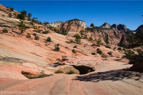
I’ve never been especially impressed with Zion National Park, even if I did enjoy climbing Angel’s Landing, and the Narrows really is fun. Well, on this trip, I managed to find a truly enjoyable side of Zion! (Maybe because most of the hikes were only semi-official with very few people, well outside the main part of the park?) Our first adventure was out to Observation Point. The road was terrible (do your nerves a favor and take the shuttle!), but the views were fabulous!

We were supposed to hike the East Mesa Trail to the Overlook the next day, but since the overlook isn’t marked in any way, we ended up going down to Jolly Gulch before going back and catching the overlook. Not a bad mistake, for sure.

Then it was up the Many Pools Route. I’ve seen friends’ pictures and was keen on seeing it for myself. It didn’t disappoint!

The next day, I led my group on a merry chase up the Petroglyph Pools Route. Besides rock art, there were a few pools, and then it turned into a slot canyon. We scrambled up over the boulders to the first dryfall, then a couple of us continued via sketchy ledges and chimneying to a point we didn’t want to climb (could I have done it? Yes. Did I feel safe doing it? No.).

On our way back, I saw a guy with a huge lens on his camera. It turns out there were bighorn sheep nearby! He was all smiles, and I was pretty happy, too!

Our final hike in Zion was up to Pine Creek Falls. Again, this is not an advertised hike. The parking area was double-parked; it was so full. But we saw a grand total of three families on the hike. Don’t ask me where everyone else was hiking – but I also wasn’t going to complain about having the falls to myself for about an hour.

And that’s a lot of photos already, so I’ll talk about the rest of the trip in the next post!

Find the Best of Canyon Country
Covering Petrified Forest, Page area, and much more in the 4 corners region and beyond, this guide aims to help to you see the very best of the canyons in Utah, Arizona, and beyond. With dozens of hikes of varying skill levels, you’re sure to find favorites in here. Buy your copy here.


2 responses to “Trip Itinerary: Page, Kanab, Zion, and more!”
Sounds like a fun trip. Did you find any hidden gems in Zion?
I did find several hidden gems in Zion! Honest, every hike in the park this trip was a hidden gem with a fraction of the people (well, Observation Point had enough people, but it wasn’t overwhelming).