Last time, I posted about the first half of our trip to Arizona and southern Utah – and now I’d like to continue the theme with the second half of the trip, all in Utah! We had a few more adventures ahead of us, namely a lot of lesser-known trails in Bryce Canyon, a few really neat slot canyons, took my group to the moon and Mars, and more! The crowning touch was visiting a state park I’ve been procrastinating on visiting for almost 30 years… and it was so worth the wait. But since that was our very last hike, and I’m doing this in chronological order…

I wanted on this trip to finish hiking all of the trails in Bryce that we haven’t hiked since our first visit in 1997. I also wanted to visit a lot of viewpoints (basically all of the overlooks in the park except for Sunrise and Sunset, which I hiked back in 2013 along with portions of the Rim Trail). Instead of filling up this post with those viewpoints, I’ll just give you a few of the best along the way. Our first major hike was out to the Hat Shop. We lost 99% of the people at the turnoff for the hike and spent a delightful morning with spectacular views. The Hat Shop itself wasn’t that exciting, but the rest of the trail was great!

In the afternoon, we visit all the overlooks! My three favorites were (easily) Inspiration Point (incredible!)…

…the Natural Bridge (really neat)…

…and Rainbow Point (great for far-ranging views).

The next day, we drove down to the town of Tropic and hiked into the main Bryce Amphitheater via the Tropic Trail in hopes that it would be easier on the knees than hiking down from the rim (it works from that perspective quite well – while there are a couple of steep sections, “steep” is flat compared to the Navajo Trail!)

My goal was to hike the Peek-a-boo Trail. Yes, I’ve hiked it before, even as recently as 2011. But I didn’t have any good photos of it, and I wanted to know if it was as beautiful as I remembered from 2001. Answer: It blew my very high expectations out of the water. Just wow!!!

While we were tired and in the area, anyway, we walked up the Mossy Cave. I’ll post pictures of the nearby spires because, honestly, they were more inspiring than the cave, IMO.

We hiked the Swamp Canyon Loop (much prettier than it sounds, if without the jaw-dropping splendor of the Peek-a-boo Trail) the next morning.

And finished up our time in Bryce on the Bristlecone Loop out at Rainbow Point (and a quick trek down the Whiteman Trail, too – a fire took out the trees, so it actually has some quite nice views).

Our next hike didn’t turn out exactly how I read online. I really like that website, but the author doesn’t necessarily feel it’s important to tell you everything about a trail. This time, he forgot to mention a couple of cliffs that had to be scaled and a dryfall that couldn’t be re-climbed in Red Breaks Canyon. But hey, once we got through all that, we were treated to a super narrow slot canyon with gorgeous striped walls. And it went on, and on, and on, and on… I finally had to turn around after almost a mile of extremely thin narrows, and dozens of delightful downclimbs!

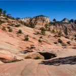
A few years ago, I finally found a hike worth taking in Capitol Reef National Park. However, Fern’s Nipple isn’t exactly for the faint of heart. This time, I found another hike well worth taking in the park, and it’s much easier – Chimney Rock Trail and the spur into Chimney Rock Canyon. The views, the towering walls… wow.

And then we went to the Moon! The Moonscape Overlook has become popular with sunrise photographers in recent years. It was beautiful!

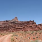
From there, we drove back to the highway and to the trailhead for Long Dong Silver Spire, which, if captured correctly, looks like something out of a sci-fi video game. However, the wind was fierce (25mph sustained), and the dust blowing up the valley through the parking area was not fun at all – and you couldn’t see more than about 5 feet! So we drove to Mars instead. Yes, there’s a real Mars life research station along a dirt road in Utah. You’re not allowed to approach the station, but there are plenty of badlands, rock formations, and views to discover nearby.

In the evening, we drove back toward Long Dong Silver Spire, just to see if the dust had settled. As we drove down the hill toward the turnoff, we could see the dust still hurtling across the road… and then it stopped. Like it had been turned off by a switch. We hung around the parking lot for a few minutes to see if it would start again (it didn’t), and then set off up the non-trail. The lighting at sunset was wild, and while I’m not sure my photos are the best representation of the area, it sure was fun to experience!

The next day’s adventures were… adventuresome. You know the site that sometimes forgets to mention pertinent details? Well, the author said Moonshine Canyon was one of his favorites because it’s easy enough for beginners. He was right about Moonshine Canyon – it was a ton of fun, even if I used the climbing rope for the first time on the trip for the dozen or two dryfalls (mind you, I didn’t use the rope except for two very complicated dryfalls, but a couple of group members did use the rope many times and were very glad for it). That part was fun. Then came the trek over the mesa and up another canyon (pretty but boring), then a pretty but too-long-for-the-hour trek across the desert, and finally back to the van just barely before dark… and then we had to drive out off the dirt road before the rain started!

We only had two days left before we needed to make tracks for home, and the first day was supposed to be quite rainy. Moab looked good, so off we went… but it rained. So we left Arches National Park and went into the town, proper… where it rained. I finally checked the radar, and the rain was over for the day, so we went down the Kane Creek Road to see the rock art. (It rained there, too, but there was also sunshine.) First, we saw the Birthing Rock…

…then we took a 4×4 route to rock art up on a cliff, which included an owl pictograph.

Then we tried to get to Funnel Arch, but this time my forgets-to-say-important-stuff friend was more accurate than everyone else on the internet… that class 4 climb at the beginning of the hike is more than we wanted to do, even with a rope! So we drove back down the road to one last rock art site, known as False Kiva Petroglyphs.

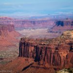
Our very last hike was one to remember! I’ve never been to Dead Horse State Park before (why pay for a state park when you can use your park pass to get into Canyonlands?), but let me tell you, it’s a different view and a beautiful one to see! We had a great time hiking the east and west rim trails – and all that rain had dropped fresh snow on the La Sal Mountains.

And then it was a push across the country to get home! The trip honestly felt short at just over 3 weeks (I’ve been perfecting the art of month-long adventures in recent years), but wow, what a lot of great stuff we packed into that time!

Discover Hidden Gems in Utah
This book aims to take you beyond the tourist destinations and Instagram clickbait to the places you’ll love. Spectacular scenery, no-crowd options, and detailed itineraries make this a great book for planning a trip to Utah. Buy your copy here.