Earlier this fall, a group member and I were discussing adventure ideas – because, that’s just what we do. We’ve ended up in all kinds of crazy places out of conversations about real and imagined adventures. This time, we were talking about the Maze District in Canyonlands. I’ve done significant research about the Maze District for other (yet undisclosed) work assignments, but I’d never visited, myself. In fact, it was completely out of reach for me because I don’t have a 4×4 vehicle. It was this group member who said, “Why don’t we take our high clearance van and then ride our bicycles wherever you’d need 4×4?”

In that moment, my world changed from “like to, but it’s no use dreaming,” to “sure, why not!?!” We looked at our schedules, and the only time we were both free before the snow fell was the week before Thanksgiving. So we took off, not really sure what we’d be able to do, but with plenty of backup plans in case the Maze District didn’t work out.
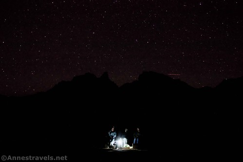
I’m happy to report that it did work out pretty well! There were things I thought we could do that we couldn’t, and things that I didn’t think we could do that were no big deal. Our biggest issue was that it was cold – we’re talking the coldest Utah has been in almost 2 years, 30s and 40s in the sunshine and then in the 20s and teens at night (all temperatures in Fahrenheit). And we were sleeping in the van, which doesn’t have a heater beyond the stock one in the engine. But somehow or other, we managed to stay reasonably warm. I’m super grateful for that – I definitely wasn’t expecting these kinds of temperatures!
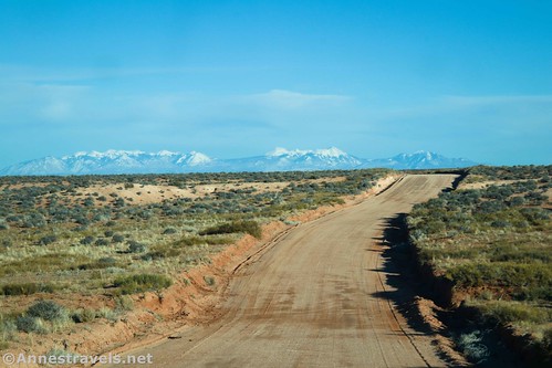
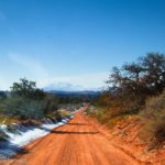
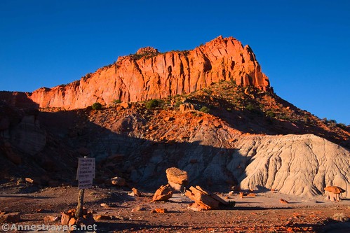
We exited I-70 west of Green River and headed south on UT-24 to the road that would take us into Hans Flat. (Note that it’s pronounced like “Hands Flat” without the d, because the guy it’s named for was Irish, not German.) The Maze District is so remote that it only has one ranger station, and even that is 40 miles from a paved road. Thankfully, the road was good enough for 2WD, even a low-clearance vehicle could do much of it (minus the little hills of sand across the road which we barely made it through in high clearance).
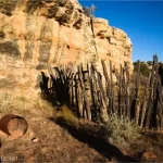
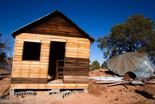
But before we got to Hans Flat, we took a detour to search for Butch Cassidy’s Cabin near Robber’s Roost. Another of my group members (who we’d welcomed to tag along with us) has done significant research on the outlaw and had figured out where to go looking for the cabin where he stayed in the early days of the Wild Bunch Gang. There’s not much left except the chimney and some old (and not so old) corrals.

We camped near there and then headed toward the Hans Flat Ranger Station the next morning. The rangers were the best; so respectful and genuinely telling us exactly what we were could and could not do with 2WD (they were right, too – I’m used to rangers erring on the side of safety, but they were spot on when it came to road conditions, even if the board above the desk was more on the side of safety).
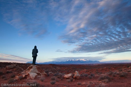
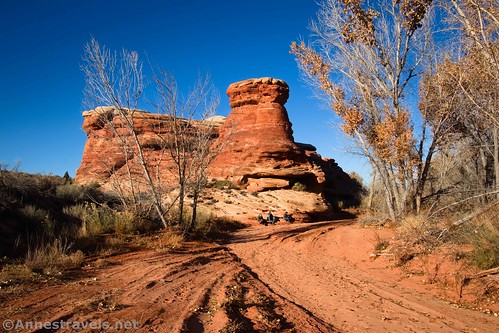
I dashed down the Spur Road for a few photos while the others pulled out breakfast.
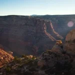
And then we headed off down the road that would take us along the top of the Orange Cliffs to the top of the Flint Trail. There’s no question that it’s a 4×4 road, but we were ok in our 2WD, high clearance van for two reasons: 1) the road was partially frozen, and 2) our driver is very experienced in driving said and other vans on dirt roads. (He claims he got his start by moving moonshine in a Toyota Camry on the backroads of the Blue Ridge for his brother-in-law in high school, but we all know he didn’t live in the Blue Ridge, let alone have a brother-in-law, at that point, lol.)

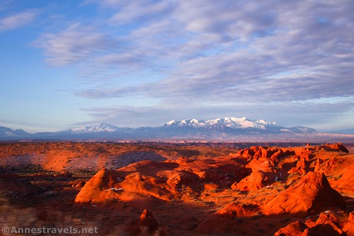
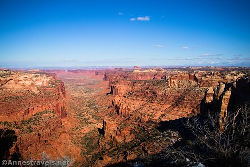
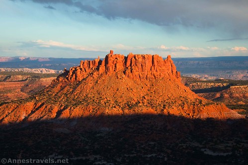
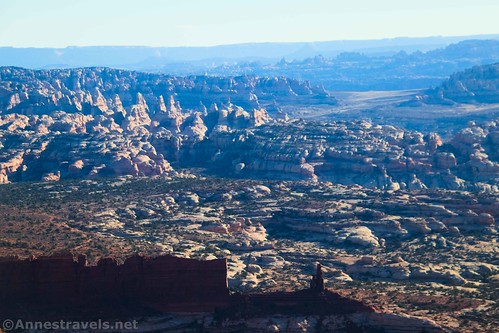
The first viewpoint is Millard Canyon. This is one of the best views we saw in all of the Maze District. The views are absolutely spectacular.
Then comes French Cabin…
…and French Spring.

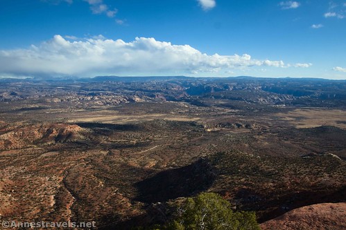
We passed by the North Point Road to continue past the Bagpipe Butte Overlook (another spectacular viewpoint, especially in the afternoon).
We drove by Flint Seep and finally stopped for lunch at the Flint Trail Overlook. Again, this had a great view, and we got to watch a Tacoma drive down the Flint Trail (a very rugged road down the Orange Cliffs). Given that the rangers and the people in the Tacoma were the only humans we saw all day, it was really neat that we got to see them go down the famous road!

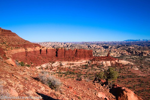
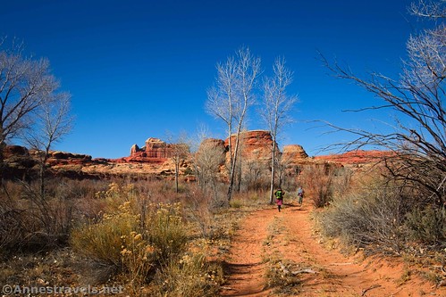
The rangers had recommended that we ride our bicycles down the Big Ridge Road (which spurs off of the road we were driving shortly before the Flint Trail drops over the edge of the cliffs) to the two viewpoints on the Neck (a narrow part of the ridge where you can look down on both sides). This wasn’t part of my plan at all, but I’m so glad we did it. We found out that biking at 7,000ft. is no joke when you live 300ft. above sea level, and the road was mostly treed. But the views of Happy Canyon…

…and down on Poison Spring Canyon were by far worth the trek. Just Wow!!!
I also biked up to the top of the Flint Trail and took a few pictures.
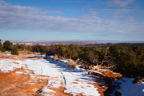
We had to beat a hasty retreat to get out before dark, taking a stealth campsite just down the road from the ranger station (it’s perfectly legal, and the rangers recommended it). The next day, I planned to drive the North Point Road. The rangers said it was 4×4 only, but things I’d read online said it should be fine for high clearance, 2WD. Well, the rangers were right and the internet was wrong. We got a quarter mile down the road and found a crazy slickrock descent. Nope, not doing that.

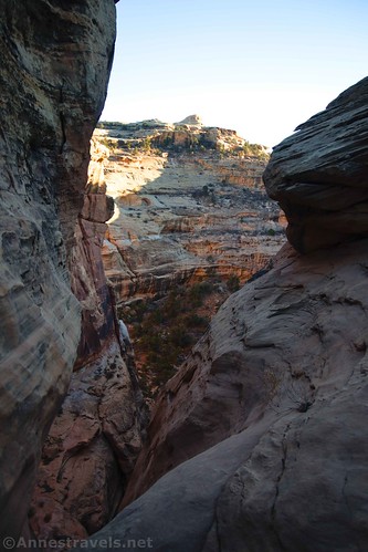
Some of us walked down the road to see if it was bikeable. (It is, but we didn’t end up biking it.) I took this grand opportunity to hike down the North Trail Canyon Trail. I went far enough to see the rock spire – awesome!

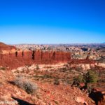
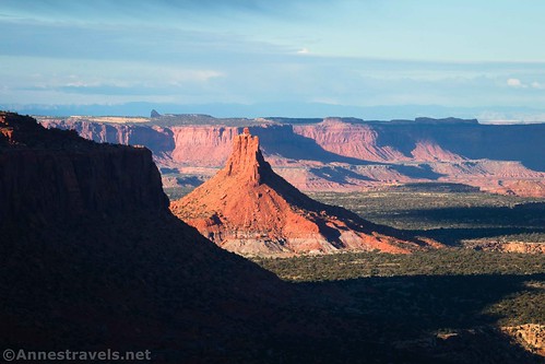
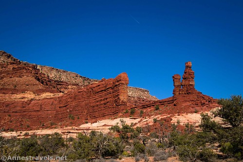
While I was pretending I was a trail runner (I’m not!), the rest of my group was discussing plans and ideas. From where we’d parked, they could see Observation Rock, and three of them had been thinking, even from the day before, how much fun it would be to climb to the top. It looked doable, so we parked at French Cabin and headed off in the general direction of the rock. The route was a crazy slickrock scramble, and I was grateful for a hand up in more than one place (we’re talking mostly a Class 3 scramble with some Class 4 moves). But the view – wow!! So many canyons, spires, rock formations, snowy mountains, buttes, cliffs… so spectacular!
The rangers had recommended against driving all of the way back out to UT-24, all of the way down to US-95 in Hanksville, and then the 40+ miles on the dirt Waterhole Flat Road. Their reasoning was that it was so much time and so much gas; why not just do things in the Hans Flat area? They were absolutely right – it took us close to a day to do all that driving. But oh, the views! Waterhole Flat Road is one crazy amazing view after another. And it was 2WD-friendly!
We stopped along the way and I hiked a short distance up the Cove Canyon Road…

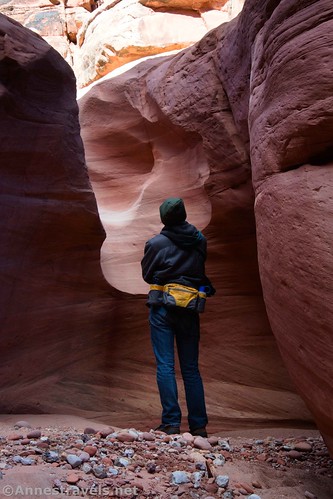
…before we hiked Cove Canyon. It’s a fun little hike; not really much in the way of narrows, but there are a couple of nice dryfalls before you get to a cliff-edge dryfall that would have required ropes and canyoneering.
From there, we drove up to the edge of the Orange Cliffs District of Glen Canyon National Recreation Area. (Much of the Maze District of Canyonlands National Park is actually in Glen Canyon NRA, so the two parks work together in terms of regulations, etc.) We didn’t have a permit to camp in the park, so we took advantage of the campsite right next to the sign that says, in effect, “no camping without a permit beyond this point.” We hopped on our bicycles and rode down to the old Chaffin Cowboy Camp.

The corral and associated junk is all that’s left, so some of us trekked down the nearby wash. I’m glad we did; the dryfall is at least 300ft. straight down. Standing on the edge (not too close!) was crazy!
The next morning, we got up as soon as it was light and headed along the rest of the Waterhole Flat Road. The rangers had warned us that some of the road along the Black Rim wasn’t really 2WD-friendly. And given their accuracy on other roads, I was nervous. But I figured we’d just ride our bikes if we couldn’t get to where we wanted to be. By some miracle, we were able to get up the worst hill and then all of the way to the lower end of the Flint Trail.
From there, it was a hop, skip, and a jump to the Overlook on the Golden Stairs Camp Road.
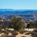
At this point, we realized we didn’t want to take the van any further. So we picked up our packs and walked to the Golden Stairs Trailhead, out onto the China Neck, and then started down the Golden Stairs Trail.

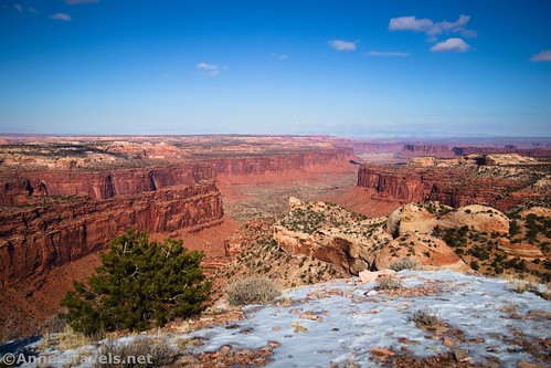
It was spectacular, especially coming back in the afternoon. The views of the Maze, the Dollhouse, the Needles (across Cataract Canyon), and the Mother and Child formation were incredible!
At the bottom of the Golden Stairs, we turned left on the Dollhouse Road and walked around the Mother and Child Formation. En route, we met our first of two couples (the only four people we met the entire day). They were camping at one of the sites along the road and then backpacking on the Fins Trail. Sometimes you just meet the nicest people in the wilderness! (Check out Dakota’s photography here!)
Just on the other side of the formation, we turned onto the Fins Trail. It’s an official-unofficial trail down into the Fins – the southern side of the Maze. We dropped down to Lou’s Spring…
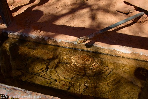
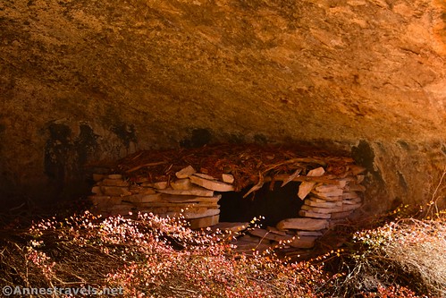
And then over to see Cedar Bark Ruin. I’m not sure I’d do the latter again, but Lou’s Spring had a really peaceful, interesting quality to it.
We were running out of time, so it was a quick trek back up to the Dollhouse Road and then back up the Golden Stairs Trail to where we’d parked, then a race against darkness to get back out of the park so we could camp. We made it (barely!) and turned in for a much-needed night’s sleep. None of us were used to hiking 10 miles in a day!
We spent the next day driving out on the Waterhole Flat Road (with a stop to see the Cataract Canyon Overlook)…

…and then around to the Needles District of Canyonlands. Last year, some of us had hiked the Peek-a-boo Trail. It was a phenomenal experience, so we wanted our group member who wasn’t able to hike it with us to be able to experience it. It was a gorgeous morning, despite the predicted cloud cover.
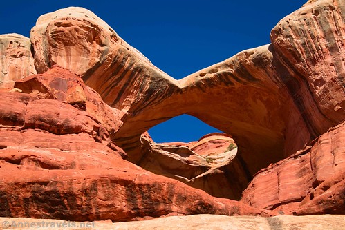
We made it to the end of the ridgeline in record time, so we decided to skip the rock art and hop down onto the Salt Creek Road (which was closed) and take the road down to Horse Canyon. From there, we hiked up to Paul Bunyan’s Potty, an arch high above the canyon.
Several of us scrambled around it for a while before heading back downcanyon (no time for Tower Ruin that day!) All I can say is that Horse Canyon is a lot more scenic than the Salt Creek Road!
By the time we made it back to the junction, we’d decided to take the dirt road back down Salt Creek to the Cave Spring Road and then hike roads back to where we’d parked in the campground. It was a great choice… though we did end up hiking a total of 16 miles that day. What? How on earth could it have been that long? It certainly didn’t feel like 16 miles!

And then it was a push for home! But what spectacular scenery we’d seen, what great memories we’d made, and what great pictures I have to share with you over the next many months!
A few things to think about if you visit the Maze…
All of the road conditions mentioned here are what I found in November of 2022. Road conditions vary widely due to blowing sand, recent storms, and times of year. Do not attempt these roads in wet weather.
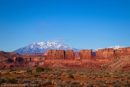
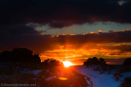
Yes, that’s snow in many of the pictures. The sun beat down on Hans Flat but the snow still didn’t melt. That made us realize just how cold it really was…
No fee is charged to enter the Maze District (there is a fee to enter the Needles District). They make up for it in camping permit fees… or maybe it’s just not worth trying to collect the fees since so few people visit?
If you travel the roads in the Maze, always bring far more food and water than you think you need. We also brought an extra can of gas (though we didn’t end up using it). If you need water in the town of Green River in November, the only place I found was the Maverick station… it has one pump and we shared it with an RV couple. There is no potable water or electricity in the Maze, even at the Hans Flat Ranger Station. (The ranger station does have a primitive toilet, yay!)
Speaking of water, we’d put out the ice jugs from our cooler every night, and they’d always freeze solid. Even in the van, we’d have Chlorine Slushies in our water bottles every morning. We turned it into a joke, because you have to laugh or something to stay warm after crawling out of your nice warm sleeping bag!
Have spare tires. We were fine, but an official park vehicle (!) was stranded while we were visiting due to having two flats on the Dollhouse Road. They were in contact with the other rangers, etc., but it was a good reminder to us to 1) be careful, and 2) be prepared.
The chances of you meeting people in the Maze is extremely low, and in the off-season, the very fact that you met someone makes it worth stopping to talk to them. One woman hit the brakes of her bike into a skid, jumped off her bike, and shouted, “Hey, another human!” She was so excited to see us.
Bikes are only allowed on the roads, not on the trails. Just FYI.
We had spotty Sprint/T-Mobile and Verizon service on top of the Orange Cliffs. It was much worse down on the Waterhole Flat Road but sometimes still available. Don’t rely on your cell phone out here. The park even discourages GPS usage because of weak signals (my dedicated GPS device did fine).
Camping is allowed outside of the park on BLM land (usual guidelines/rules apply). Inside of the park, you’ll need a permit, available at recreation.gov. You must (!!) check in with the Hans Flat Ranger Station before going to your first campsite. If you arrive after hours, you’ll have to drive a quarter mile out of the park and camp there instead of in your campsite so that you can check in the next morning. I don’t know why the legalities, but it’s worth knowing if you’re planning a trip.
When the rangers say it’s a 4×4 road, they mean it. Most of the roads are 4×4 only and deserve the status.
This Week’s Featured Product!
I can’t say enough good things about this book. The information in it was invaluable to me while planning my trip to the Maze District; it also contains information for Island in the Sky and Needles Districts of the park. If you want to get beyond the touristy hikes and roads, you’ll definitely want this resource! Buy it here!