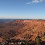
The Fisher Towers
Fisher Towers is a small BLM-managed park just outside of Moab, UT. The main attraction is the thin, red, sandstone “towers” that stand away from a cliff edge. There is a trail that takes you up among the towers, and then to a viewpoint. Many people come out here to climb the towers, but the view is also very nice. The park is at the end of a good dirt road (accessible by 2-wheel drive vehicles) off of Rt. 128 25 miles from Moab, Utah. The convenience of the park—it’s located on a road that connects I-70 to Moab—contributes to its popularity.
The trail to the towers starts on the right side of the gravel parking lot next to a trail register. Actually, there is a campground there as well (5 sites; $12 if you pay, $15 if you don’t (3/10)), and the parking lot is at one end of the campground. It may be a little confusing figuring out where you are supposed to park. I believe that at the end of the road you take the left fork to get to the campground, and the right fork to get to the parking area.

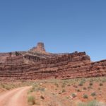
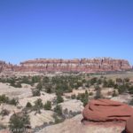
Another view of the Fisher Towers
The trail up to the towers is moderately difficult, and along the way you will encounter some fairly steep sections, a ladder, and some rocks that serve as stairs. The trail starts out going downhill rather steeply, but soon it starts to climb. After about a mile you will reach the base of the tallest tower—900ft. Many people decide to stop here and climb this tower, or they go a little farther and climb some of the smaller towers. From here the trail continues up through the towers and then away from them to a viewpoint, where you can get a nice view of the towers and the surrounding area.
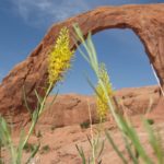
At the viewpoint, you can see Fisher Towers (to your right), Castleton Tower (to your left) complete with rock formations named “the rectory”, “nuns”, “bishop”, and “the Sister Superior” (and some of the rocks actually look like their names!), the Colorado River (straight in front of you), onion creak road and the Monti-La Sal Mountains (behind you), and, way off in the distance, I-70 (right, up the valley–you can see the tracker trailers driving by). Be sure to look at the squiggly rock formation on top of one of the towers. This is a favorite with climbers.

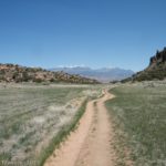
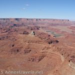
Onion Creek Road from the end of the trail
If you brought binoculars with you, look over to your left on the valley floor. When we were there, there were some Indian tents and African huts placed in a grassy place with straggly trees around. It looked enough like a savanna in Africa that the African huts looked slightly believable, but the Indian tents made the picture completely unbelievable. Oh, well. It’s interesting, anyway. A lot of movies were filmed in this area (film auto tour instructions can be found http://www.discovermoab.com/pdf/movie.pdf), including several Chevrolet commercials on the top of Castleton Tower.
Fisher Towers is special in that few places on earth look quite like this: you could only find scenery like this in Utah.
Cost: Free
Length of Trail: 4.4 miles, round trip
Facilities: Small campground, small parking lot, pit toilet
Trail 
![]()
![]()
Road ![]()
Signs ![]()
![]()
Scenery
Would I go 100 miles out of my way for this? ![]()
![]()
![]()
Overall Rating: 
![]()
This Week’s Featured Product!
Look beyond the national parks to the fantastic scenery around Moab with this guide. (A few of the hikes are from Arches or other parks, but most are on no-fee land.)