


One evening in May, we decided to drive to the end of Rt 270 from Moab, Utah, to find a place to camp. After the Potash plant, the road becomes dirt, but it’s a fairly good road as dirt roads go out there, so we didn’t have much trouble driving up to a place where others had camped before us. The next morning we got up and realized: Hey, we can actually drive this road all the way to Island in the Sky (our next destination) in Canyonlands National Park from here instead of going nearly all the way back to Moab to get there. Thus began a saga I won’t soon forget, both because of the stunning beauty of what we saw, and because it was such an exciting experience.
(Affiliate links are present on this page.)
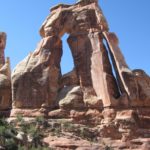
To get to this place, we had to drive down Rt 279 along the Colorado River. Rt 279 turns left off of Hwy 191 not long after you cross the Colorado River if you’re coming out of Moab. If you’re coming from the north, the turn is shortly after you go by the entrance of Arches National Park. A sign at the beginning of the road gives the mileage; you will be driving all the way to Potash at the end of the road (I believe it’s about 15 miles). Along the way you will be following the Colorado River, and will pass several cool little places to stop of you have time. Portal Overlook is a nice little hike (2 miles RT) up the side of a cliff to a lookout over the Colorado River and Moab. Use caution in this area, as there are no railings to keep you from falling over the edge, and it’s a very, very long way down. Another nice feature is Corona Arch, a huge Utah-red-rock arch that rivals some of the arches in Arches National Park. You can read about Corona Arch here.

You will know you have reached the “town” of Potash when you see the factory-type structure on your right. Also on your right are a couple of old locomotives, which fascinated some of the children in our group. We didn’t stop, and I don’t know if you’re supposed to, but it’s at least very interesting to look at. The lighting here is best in the morning, and by evening it is very much in the shadows of the cliffs above it. After you pass the factory, you will be on the Potash Road.

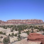
Keep driving past the Potash plant and along the road that turns to dirt after the plant. By the way, in this area is a boat launch with a primitive toilet at one end of the parking area. If such things matter to you, you might want to stop and use it, as it is the last one you’ll see until you reach Island in the Sky, a very long way up the road. The dirt road continues up a hill, and then across the top. Here you start to drive away from the Colorado River, which you have been following almost since Hwy 191, and begin to get a taste of the scenery ahead. On every side of you is classic red Utah rocks, and below (although you can’t see it at this point) is the Colorado River. The road continues to wind its way through and around the huge red sandstone fins, rocks, and boulders. From here, all mileages will be from the Potash plant.

After you’ve driven about 4 miles past the Potash plant, you will come to the settling basins used by the Potash plant. These are really weird-looking, as the plant puts blue dye into the settling basins to help the water evaporate faster, leaving the potash (K2CO3) behind. (If you’d like to know more about how the Potash plant works, check out http://www.intrepidpotash.com/AboutUs/LocationsOperations/MoabUT.aspx). The very red rocks behind the blue water in the basins make for very interesting pictures, although the settling basins themselves are inside of chain-link fences.
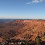
Keep driving along the Potash Road as it continues to twist its way between red-rock spires and fins, the classic Moab Utah scenery. In fact, some of the off-road tours that start in Moab come this way. I don’t blame them at all: the scenery is stunning!
At some point after this (I’m sorry I don’t know the exact mileage), you will leave the Potash plant’s property, and enter BLM-owned land. A regulation board and a fence will tell you when you are entering BLM land.

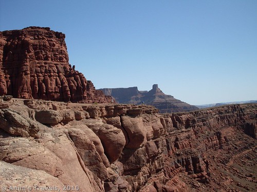
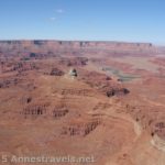
About 8 miles after the Potash plant the road will get close to the Colorado River again. However, instead of being so close you could launch a boat from the side of the road, you are now several hundred feet above it. Keep driving for another couple of miles, and you will see a dirt parking area off on your left (actually, it could just be a very wide section of the road, except that it goes just about to the edge of the cliff). If you park here, you can get out of your vehicle and look at the Colorado River as it snakes its way through the canyon, several hundred feet below you. The parking area is huge, and each part has a different view to offer. My favorite part is at the far end, where some purple “mushrooms” (they almost look like hot-cross buns) stand next to the cliff edge. If you’re surefooted, you can climb down the slope to the mushrooms and walk out on them for really fabulous views of the canyon. Use extreme caution, as there are absolutely no guardrails or anything else to keep you from falling all the way to the bottom.

After you’ve enjoyed the view, continue down the road. Not long after this, you will enter the Island of the Sky district of Canyonlands National Park. A self-pay fee station greets you, where you can enter your information and pay your entrance fees. By the way, the mileages may not seem very long, but because of the condition of the road, it took us a good 5-6 hours to get this far. In other words, even though it’s only 10 miles from Potash to the overlook, it takes a lot longer to drive because of the condition of the road.
Thirteen miles beyond Potash, you will come to a fork in the road. In my opinion, you have now gone through the prettiest section, but we really wanted to go up the Shaffer Trail, a crazy road that climbs the side of the cliff up to the main road in Island in the Sky. However, we thought we’d first turn left and go down the White Rim Road for 2 1/5 miles to Musselman Arch. A sign shows which way to turn.

The Potash Road is definitely a 4×4 road, and probably wouldn’t be passable at all when wet. However, we were able to do it without much difficulty with a high-clearance van. The White Rim Road, on the other hand, should only be attempted if you have 4×4 and don’t mind shaking up your vehicle a bit. We did make it to the arch, but, oh, that was one rough drive. I wouldn’t want to do that to the vehicle again any time soon!
Anyway, Musselman Arch is a huge hole in the cliff. It is not a long walk from the small parking area to the arch itself. You can walk right out to it and look several hundred feet down to the valley below, if you want to. However, please keep in mind that there are no guardrails, and falling would be quite easy. Because of the roughness of the road and the difficulty of taking a good picture of the arch, I wouldn’t recommend that you go out of your way for it, but it is a nice little feature if you want something to do.

On the way back to towards the Shaffer Road, we stopped at a little pull-off with a sign that said “Balancing Rock”. This was actually worth stopping for, as it is another overlook of the Colorado River and classicly beautiful Utah scenery. I would recommend this one if you’re vehicle is up to the drive.
Back at the Potash Road/White Rim Road junction, we went left (if you’re coming off of the Potash Road, that’s turning right), and continued up towards the Shaffer Trail. This part of the White Rim Road wasn’t much better than the section near Musselman Arch, although it might have been slightly better. For another 4 miles, the road switchbacks, twists, and turns, and it crazily climbs the side of the cliff to the mesa above. This is the famed Shaffer trail; and we made it to the top!

However, we didn’t make it without some “fun” along the way. About half way up my sister, sitting directly behind me, decided she needed to take a drink. Only problem was, as soon as she opened her waterbottle we hit a huge, unexpected bump, and water splashed out of the bottle—right down my neck! I screamed, and then laughed, because the weather was warm, and I knew my shirt wouldn’t stay wet for long, but we have a new regulation for driving on dirt roads: “This is a N.O.B.A.T.H. zone. Please refrain from drinking—or opening waterbottles—until further notice”!
Once you reach the top, you can turn left and go down to the attractions of Island in the Sky, or you can go right and out of the park. Or, you can just look back at the road, and be amazed that you actually drove up that!
Fees: $30 if you enter the Island in the Sky district of Canyonlands National Park. America the Beautiful, Golden Age, and Golden Access Passes also accepted.
This Week’s Featured Product!
Did you know that you can get a guide specifically for the Potash Road? Discover arches, dinosaur tracks, rock art, and more along the way!

4 responses to “Prettiest Scenic Drive I’ve Found in Utah: The Potash Road”
[…] in the group!). It twists and turns, and eventually crosses a butte. You can also see the potash plant that is on the other side of Moab, and there are some educational signs about the forming of the […]
[…] places worth visiting at least 10 miles down a dirt road. The picture is from the Potash Road near Canyonlands National Park in […]
[…] The Potash Road in Utah. Always take more water than you think you’ll need into the wilderness, especially the desert! […]
[…] from the “town” of potash along the Potash Road, then up the Shafer Trail into Canyonlands National Park, Island in the Sky District. The views of Utah canyon country are […]