

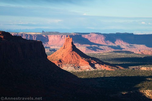
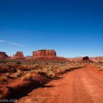
The dirt road between the Hans Flat Ranger Station and the top of the Flint Trail is unique in the Maze District in that it’s on top of the Orange Cliffs. Most of the area commonly called the Maze District is below the Orange Cliffs. Being above most of the rest of the park, the road offers opportunities for great views down on canyons, up to mountains, and over to buttes and spires. The views from the road, itself, aren’t that good, but it’s not hard to stop at viewpoints along the way.
Quick Stats
Note: Some of the links in this post are affiliate links. If you click one and purchase something, I may earn a small commission without an extra cost to you.

It’s hard for me to know what to call this section of road between Hans Flat and the top of the Flint Trail. Some consider it part of the Flint Trail. Others think part (but only part!) of it is an extension of the Hans Flat Road. I’ve also seen it called Roost Road (definitely wrong; Robbers Roost Road is nearby but is a totally different road). Personally, I like to think of it as separate from both the Hans Flat Road and the Flint Trail: firstly, because it really is a different character, and secondly, because a different set of vehicles can drive it. The road to Hans Flat is ok for most vehicles; this section of road is usually accessible to high-clearance vehicles (more on that later – you’d be better off with 4×4), and the Flint Trail is definitely 4×4 only. So I’ll call it by its generally accepted number: NP-633.
And while we’re being technical, the road isn’t actually in the Maze District: It’s in the aptly-named Orange Cliffs District of Glen Canyon National Recreation Area. However, since these lands are administered by Canyonlands National Park, the area has a blanket name of the “Maze District.”

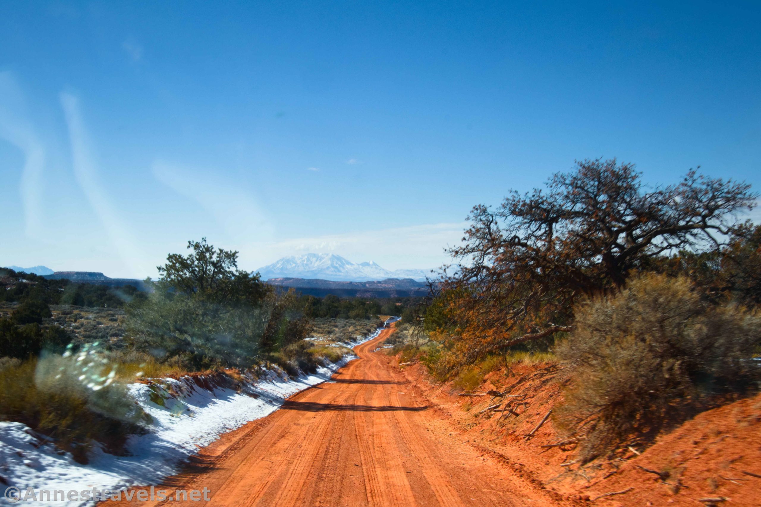
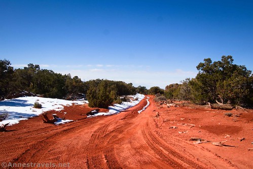
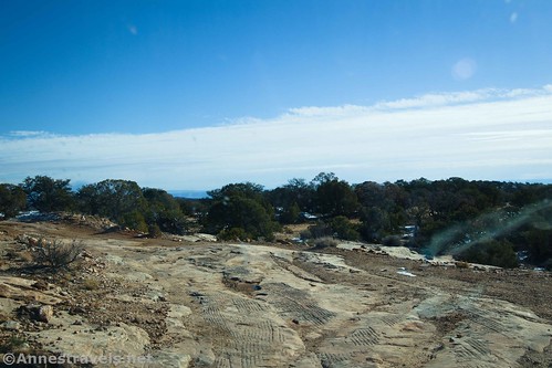
Technicalities out of the way, let’s get down to the practical side of NP-633. It’s dirt for its entire length (12.3 miles) with occasional slickrock sections. The road between Hans Flat and the Flint Trail is generally considered a 4×4 road, but it’s not uncommon for high-clearance, 2WD vehicles to traverse it in dry weather (I’ll be describing it from the perspective of a 2WD Ford E150 van).

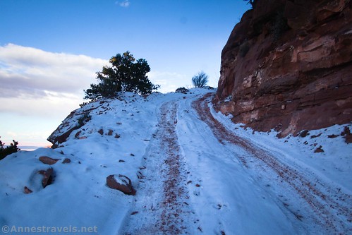
There was November snow on the road when we started up it from the Hans Flat Visitor Center (follow the sign for Flint Trail) on a chilly fall morning (it was unseasonably cold that week). But it was only a dusting, and we cheerfully drove over the first hill.
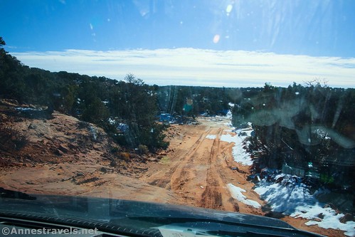
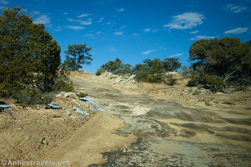
Directly on the other side, we ran into our first questionable section of road – in fact, one of the most difficult sections on the entirety of NP-633 between Hans Flat and the Flint Trail. It was a sketchy section of dirt and slickrock. Between the skill of our driver (this isn’t his first dirt road) and a good spotter (also not his first dirt road), we made it down and up the other side (also slightly sketchy, but not as bad as the first one).

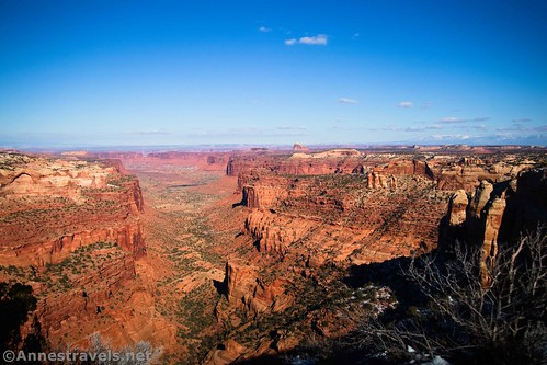
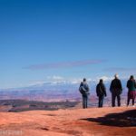
Almost a mile from the ranger station, the Millard Canyon Overlook is on the left. Per me, this is the most beautiful overlook along the length of NP-633, so it’s well worth a stop, especially in the afternoon. (I’ll be detailing the viewpoints along the road in another post, so, at this point, I’ll just mention each viewpoint’s existence).
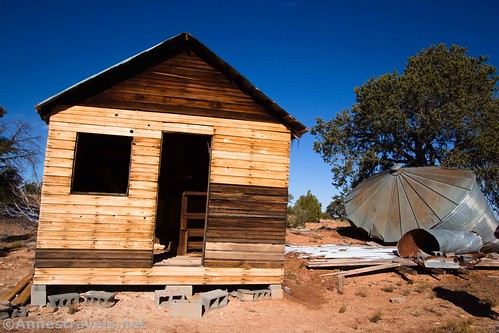
Keep driving another 1.3 miles (and over another sketchy slickrock section or two) to where a side-road goes off on the left. A sign on the right says simply, “French Cabin.” The cabin was built by an oil prospector in the 1920s. It’s worth a quick side trip if you have time and interest.
Just a quarter mile beyond the road to the cabin, another sideroad on the left leads to French Spring. I found this less interesting than the cabin, but it’s still worth a visit if you don’t mind a little scrambling. The spring and cabin were named for early Basque and French sheepherders in the 1890s. Despite this, the sign reads, “French’s Spring” (don’t ask how the ‘s got in there).

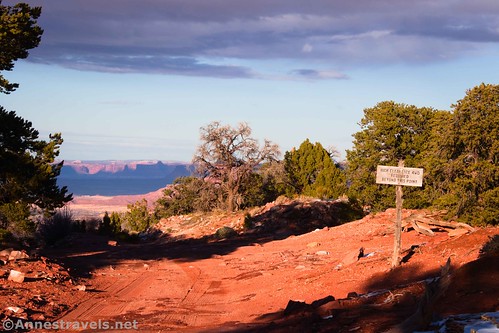
A tenth of a mile later (2.5 miles from the ranger station), the North Point Road goes off on the left. A sign points toward North Point Road, Panorama Point 8 and Cleopatra’s Chair 9. It’s a true 4×4 road; the next day, we only got to the North Point Campsite before a crazy slickrock descent turned us back.

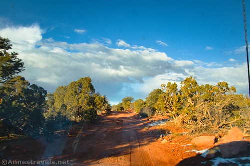
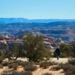
But at this point, we continued down NP-633. The road chills a bit; it’s mostly dirt with occasional rock sections (that said, the washboard can be annoying, and watch for washes). As you keep driving, you can occasionally get views to the Henry Mountains (right) and Junction Butte/La Sal Mountains (left). Most of the road is in the trees, so any and all views are appreciated.
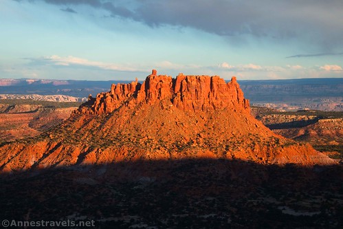
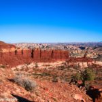
Pass Bagpipe Butte Overlook on the left about mile 8.9. Again, this is a great afternoon view, though not too late, as the butte is close enough to the Orange Cliffs to be shadowed as the sun goes down. The next excitement is Flint Seep Campsite on the right at mile 11.1. The seep (which is now mostly dry) and nearby Flint Flat were named for the abundance of flint chips found in the area. Early inhabitants used flint chips to put tips on their arrows.
Three-quarters of a mile beyond Flint Seep, Flint Trail Overlook is on the left. Again, this is a good (if quick) stop. We decided to eat lunch here while enjoying the view and watching a Toyota Tacoma descend the Flint Trail. I suspect we two were the only groups on the road that day.

It’s only 0.4 miles beyond the overlook that the Big Ridge Road (Happy Canyon) goes off on the right. Take the left fork to ascend the final tenth of a mile to a small parking area and the beginning of the Flint Trail’s descent of the Orange Cliffs. The Flint Trail is the only road that takes vehicles from the top of the Orange Cliffs to the bottom (you can also come in via the Waterhole Flat Road, but that’s another post), and it’s a true 4×4 road.
I’ve heard that the Flint Trail is one of the most difficult non-technical dirt roads in Utah, right up there with Elephant Hill in the Needles District. It has low-hanging cliffs (your vehicle can’t be too tall!), sheer drop-offs, narrow tread, slickrock steps, and curves so tight you’ll probably need to do multi-point turns to get around them (don’t even think about passing someone going the other direction). The road was built by cattle ranchers wishing to drive their herds between pastures, but it was improved by uranium miners in the 1950s and updated for slightly safer conditions by the National Park Service in the early 2020s. It’s still a white-knuckle drive, and we had no interest at all in trying it in snowy conditions in a 2WD van.

But that’s that! If you’re looking for more interesting things to see, I highly recommend driving or hiking or biking down the Big Ridge Road to the Neck for some of the best views I saw in the Maze District… but that, too, is a topic for another post!
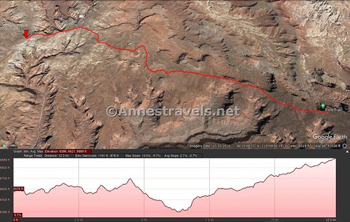
Total Distance: 12.3 miles point to point
Elevation Gain: 1,191ft. up, 878ft. down
Facilities: Primitive restroom, a picnic table, and visitor information at Hans Flat. No water is available.
Fees: None (The Maze District doesn’t charge an entry fee; they make it up in camping fees.)

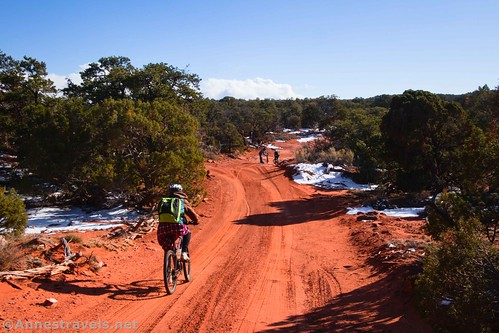
Trail Notes: You’d be advised to have 4×4 for this road, but it’s not 100% necessary, as I proved. Biking the road is an option – just realize that you’re on sand/loose dirt most of the way, and therefore it’s not much fun. Pets are not allowed in this part of the Maze District/Orange Cliffs District, even inside a vehicle. Be ready for self-rescue and bring along extra blankets, food, water, and a spare tire – it could be a while before anyone knew you hadn’t come back, let alone pinpointed your location and rescued you. GPSes have notoriously bad reception out here, though I never had any issues with my Garmin. Cell phone connection was spotty (Sprint/T-Mobile did better than Verizon).
Road 
![]()
![]()
![]()
Signs ![]()
Scenery ![]()
![]()
Would I go 100 miles out of my way for this? ![]()
![]()
![]()
Overall Rating: ![]()
![]()

GPS Coordinates for NP-633 from Hans Flat to the Flint Trail
Hans Flat Ranger Station: 38.2553495°, -110.1797751° (38°15.32097′, -110°10.78651′ / 38°15’19.2582″, -110°10’47.1904″) (6,581ft.) (0.0)
Millard Canyon Overlook: 38.2479060°, -110.1691280° (38°14.87436′, -110°10.14768′ / 38°14’52.4616″, -110°10’08.8608″) (6,589ft.) (0.9)
French Cabin Road: 38.2374510°, -110.1512750° (38°14.24706′, -110°09.07650′ / 38°14’14.8236″, -110°09’04.5900″) (6,631ft.) (2.2)
French Spring Road: 38.2352290°, -110.1508860° (38°14.11374′, -110°09.05316′ / 38°14’06.8244″, -110°09’03.1896″) (6,621ft.) (2.4)
North Point Road Junction: 38.2335730°, -110.1505300° (38°14.01438′, -110°09.03180′ / 38°14’00.8628″, -110°09’01.9080″) (6,621ft.) (2.5)
Bagpipe Butte Overlook: 38.1602510°, -110.1366760° (38°09.61506′, -110°08.20056′ / 38°09’36.9036″, -110°08’12.0336″) (6,624ft.) (8.9)
Flint Seep Road/Camp: 38.1302290°, -110.1337070° (38°07.81374′, -110°08.02242′ / 38°07’48.8244″, -110°08’01.3452″) (6,838ft.) (11.1)
Flint Trail Overlook: 38.1216290°, -110.1289350° (38°07.29774′, -110°07.73610′ / 38°07’17.8644″, -110°07’44.1660″) (6,856ft.) (11.8)
Happy Canyon/Big Ridge Road Junction: 38.1182440°, -110.1275650° (38°07.09464′, -110°07.65390′ / 38°07’05.6784″, -110°07’39.2340″) (6,871ft.) (12.2)
Flint Trail: 38.1178670°, -110.1245900° (38°07.07202′, -110°07.47540′ / 38°07’04.3212″, -110°07’28.5240″) (6,894ft.) (12.3)
The gpx file for NP-633 from Hans Flat to the Flint Trail can be downloaded – please note that this and the GPS Coordinates are for reference only and should not be used as a sole resource when hiking this trail.
Download GPX File size: 82.2 KB Downloaded 425 times
(Note: I do my best to ensure that all downloads, the webpage, etc. are virus-free and accurate; however, I cannot be held responsible for any damage that might result, including but not limited to loss of data, damages to hardware, harm to users, from use of files, information, etc. from this website. Thanks!)

Getting to NP-633 Hans Flat to the Flint Trail
The easiest way I can describe it is to tell you to go read my post on driving the Hans Flat Road. Basically, you want to take Exit 149 off of I-70, turn south, and drive UT-24 for 24.2 miles (or 0.6 miles south of the turnoff for Goblin Valley State Park). Turn left onto the road (it does have a sign for Horseshoe Canyon, Ranger Station, and Doll House 4WD, among other destinations) and drive 45 miles on the dirt road to the Hans Flat Ranger Station.
This Week’s Featured Product!
For the best book I know of that covers the Maze District, check out this one! It covers 4×4 roads, trails, and more with good maps, history, and more. Buy a copy here!


One response to “NP-633: Hans Flat to the Flint Trail”
[…] over NP-633 in Glen Canyon National Recreation Area, […]