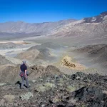
Some of you may remember when I tried to get to McNeil Point in Mount Hood National Forest back in 2016 via the Mazama Trail. That didn’t work out very well, as the clouds socked in the entire meadow and I never went any higher than the CCC warming hot (McNeil Point Shelter). Well, we did Try 2 last summer, and it worked out spectacularly. Along the way, we saw the views from Bald Mountain, enjoyed waterfalls on the Timberline Trail, reveled in the wildflowers in the meadow along the McNeil Point Trail, scrambled to even more amazing views beyond the top of the trail up Cathedral Ridge, and even found a legal shortcut trail on our way back down. It was a crazy long and hard day, but it was so totally worth the effort!
Quick Stats
This post may contain affiliate links.
If you don’t feel up to the extreme miles and elevation gain of hiking up to McNeil Point, you’re still in luck with this trail. The Bald Mountain Loop is only about 3 miles RT, and going up to the first viewpoint along the Timberline Trail is about 5.5 RT. Plus you can stop at the McNeil Point Shelter for an approximately 11 mile trail without toiling up to the top of the point.
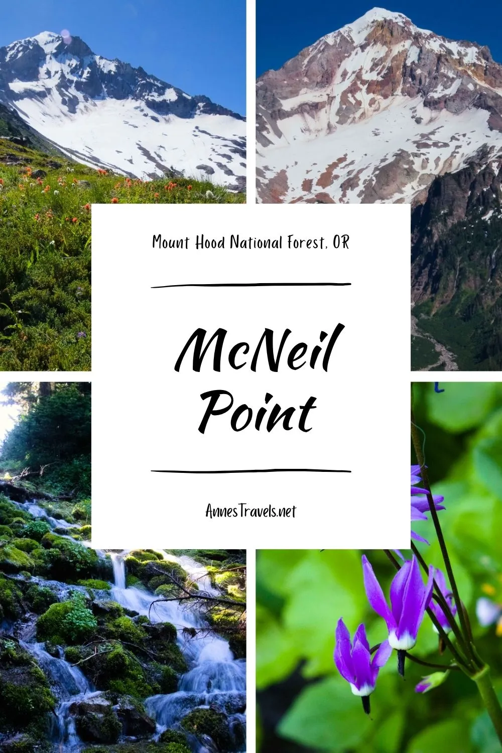
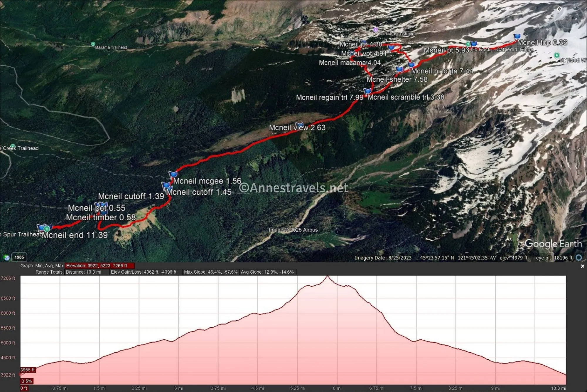
We started from the Top Spur Trailhead, reached by a sometimes-paved, very potholed (and steep) road that’s suitable for most vehicles (just watch out for those potholes!). There was a porta-potty at the trailhead, but it was so full, most people went either in the woods or drove down the mountain (not that there’s anywhere to “go” for quite some time…). From the trailhead (a sign says Top Spur TR. No. 785), the path climbs steeply up to a junction with the PCT at 0.5 miles. This is a confusing junction, as there are actually two junctions close together – turn right on the Pacific Crest Trail and then arrive almost immediately at the junction with the Timberline Trail, complete with a sign kiosk. This is another confusing junction, because four trails leave from here – the PCT to the right (and to your back) and the Timberline Trail to the left and straight. Turning left here (toward Cairn Basin) will take you faster toward McNeil Point. But I decided to go straight (toward Top Spur) in order to take in the fantastic views from Bald Mountain on the way.
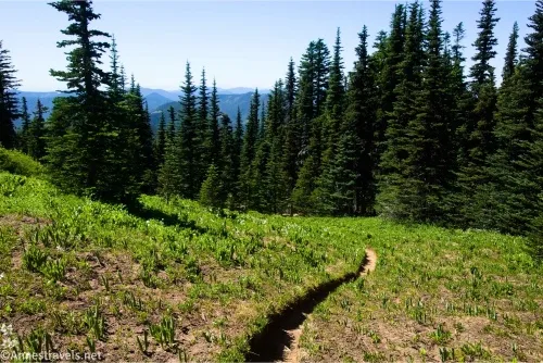
The path continues to travel through the forest; you’ll pass an unmarked and somewhat brushy spur trail on the left that would take you to the top of Bald Mountain (I was too tired on the way back down to check it out, but I hear the peak can be climbed via this social trail). Otherwise, you just need to keep hiking, and after a bit, the path will turn to come into meadows on the southern side of Bald Mountain.
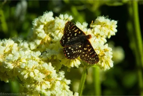
The views from Bald Mountain are fantastic; it’s worth a hike just for the approximately 3 miles loop, though views are best in the afternoon. In mid-July, the wildflowers were outstanding.
We snapped a few pictures and continued down the trail as it plunged into the forest, then came to the cutoff back over to the arm of the Timberline Trail we wanted to follow at mile 1.4. Turn left on the cutoff – it will rise steeply, then drop steeply back to the Timberline Trail heading for Cairn Basin at mile 1.45. Here, turn left to return to the Top Spur Trailhead or right to continue toward McNeil Point.
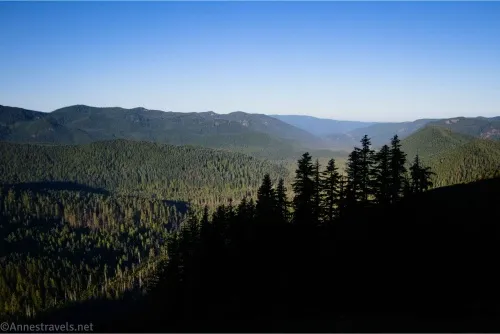
Pass the McGee Trail Junction on the left at mile 1.5. Heave a sigh of relief, as the trail junctions are over for quite some distance. The trail rises somewhat steeply but not precipitously through the forest – you may be able to see out to the north to the area devastated by a fire in 2023.
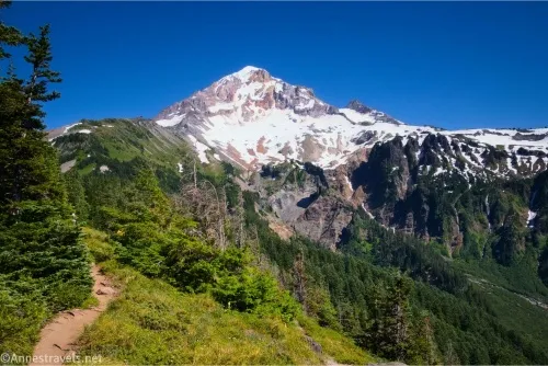
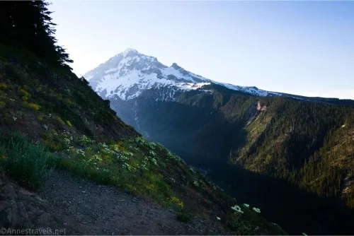
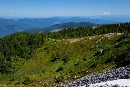
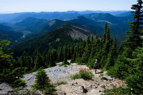
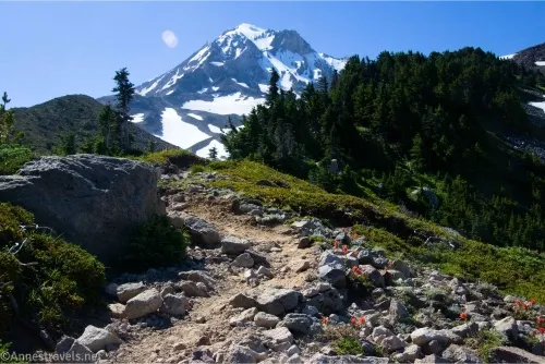
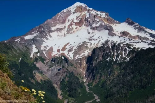
At mile 2.6, the trail pops out of the forest on top of a ridge with a fabulous view of Mount Hood. Again, this view is better in the afternoon, and again, the hike to this point is worth the mileage, even if you don’t want to go all of the way to McNeil Point.
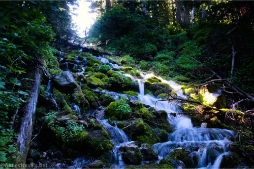
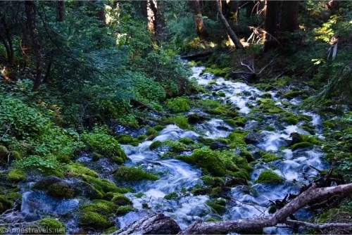
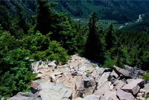
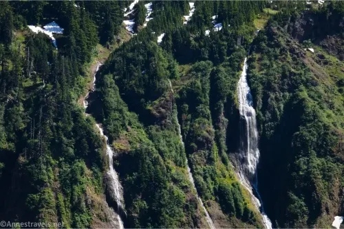
The trail moves on from the viewpoint to enter the forest again (there is a lot of forest on the first part of this hike!). At mile 3.4, a fairly defined (but not major) social trail goes off on the right in a small meadow between the trees. This is the shortcut trail up to the McNeil Point CCC Shelter. We came down this shortcut, and while it’s definitely shorter, it’s hard to say if it’s easier overall – most of the trail is extremely steep, and some of it has a slippery scree tread that was far too much fun to come down. We kept on the main path, crossing over two major streams. In mid-July, these were a fairly easy rock-hop, and one was a lovely waterfall.
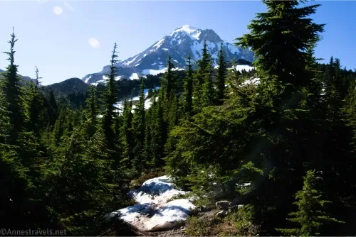
At mile 4.0, pass the Mazama Trail on the left. This is another perfectly good route from a trailhead up to McNeil Point, though it bypasses the great views on Bald Mountain and the viewpoint atop the ridge. Keep going on the Timberline Trail another almost 0.4 miles to where a sign points right toward McNeil Point (this is the last sign you’ll see on your upward journey, so enjoy it). We were glad to leave the Timberline Trail, as it was about to start crossing some sketchy snow bridges.
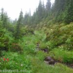
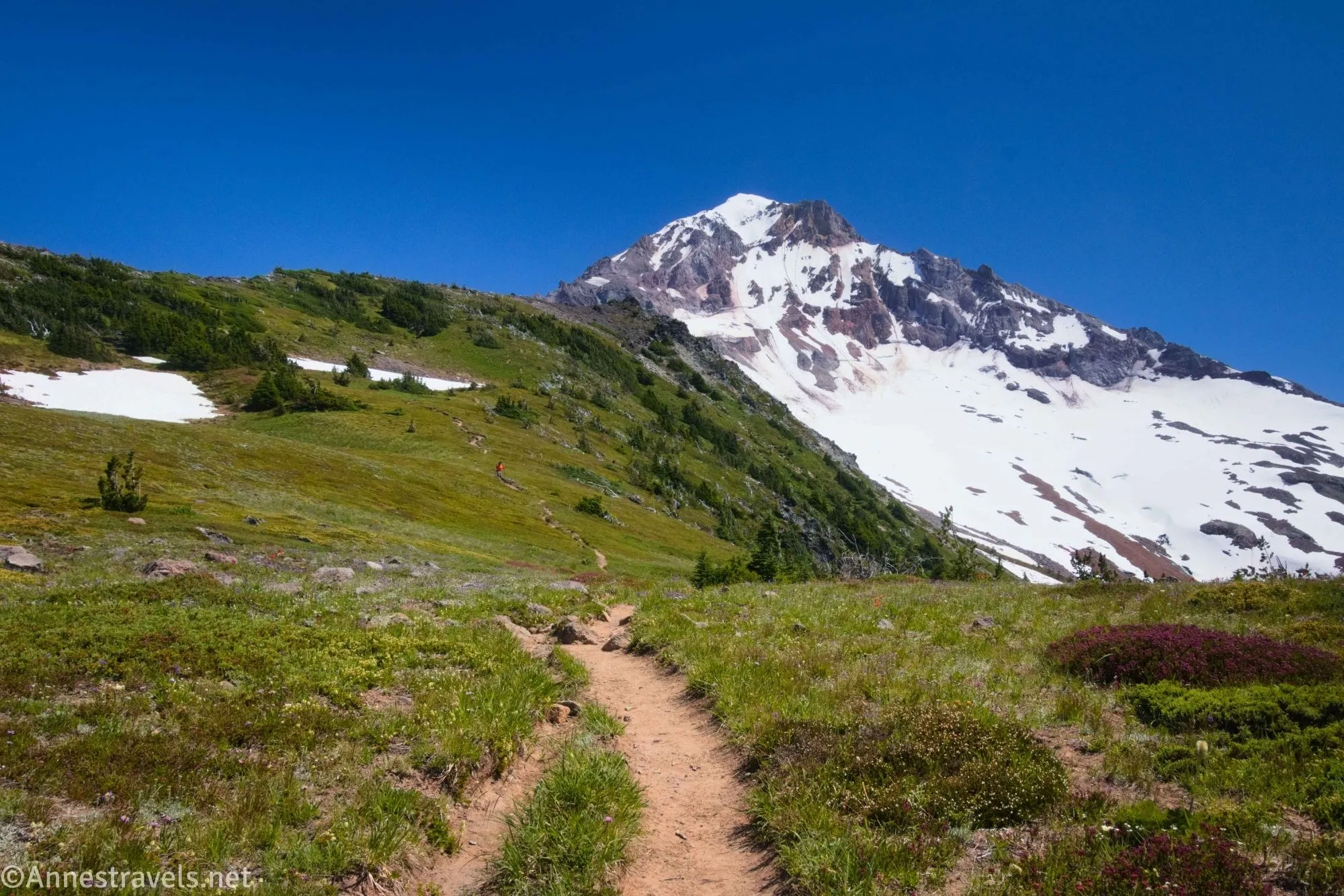
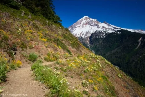
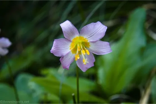
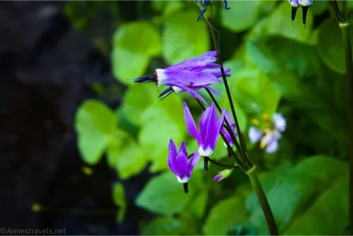
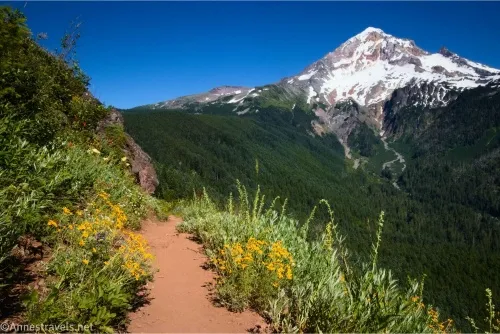
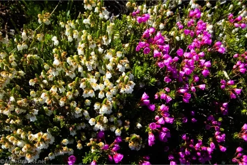
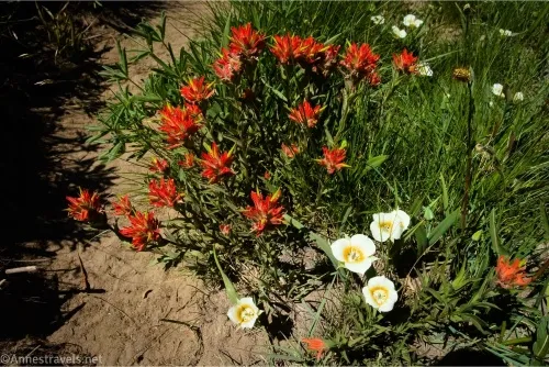
The path rises quickly up toward and then into glorious meadows. The wildflowers were just beginning in mid-July, and if you’ve followed my blog, you know how much I love wildflower meadows!
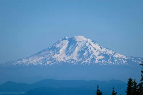
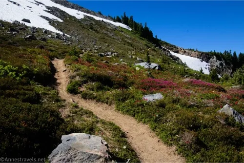
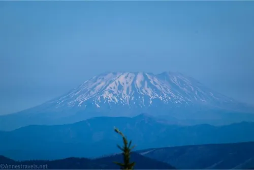
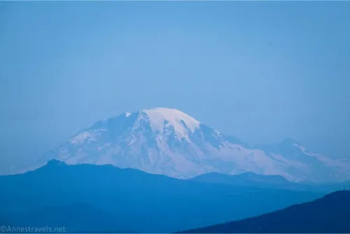
There were also stunning views to Mount Adams, Mount Rainier, and Mount St. Helens from a small viewpoint about mile 4.9. Snow still covered parts of the trail, but in general, it wasn’t hard to cross, and it wasn’t too dangerous despite the steepness of the hillside.
Keep walking through the meadows until the path splits into two major trails about mile 5.2. The right (lower) trail will take you down to the McNeil Point Shelter (CCC Warming Hut) while the left trail will continue upward toward the top of the McNeil Point ridgeline and Cathedral Ridge. While a trail does continue from the warming hut up to reconnect, we decided to take the upper trail and catch the warming hut on the way back down. (I make it sound like a decision, but in all truth, half the group missed the fact that there was a junction, and while I saw it, I wasn’t sure it was the correct junction, so it was an outcome more than a conscious choice).
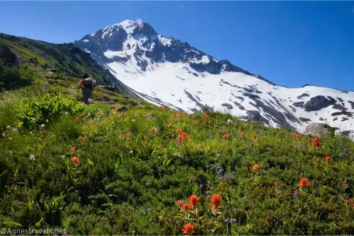
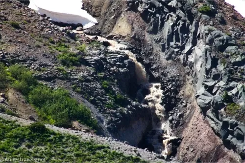
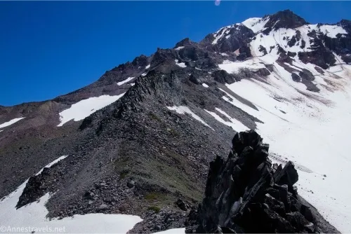
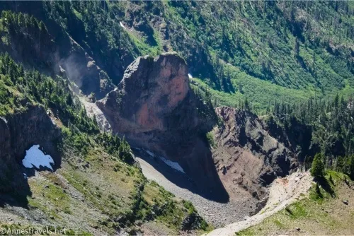
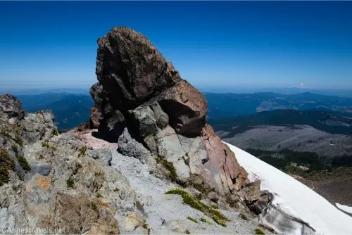
The trail keeps climbing up and up into the sky through meadows up Cathedral Ridge. The views are amazing, the wildflowers are lovely, and it’s simply a breathtaking adventure in more ways than one! The path finally reaches the line on the mountain where the trees and grass end and the rocks begin. Through this, the path is still generally a reasonable, followable path with minimal scrambling up to Ho Rock, about mile 5.8. Here, a short, unmarked path leads down to a viewpoint overlooking the valley below (toward the Muddy Fork River, which lives up to its name if my closeup photos of it tumbling down the mountain are any indication!)
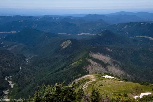
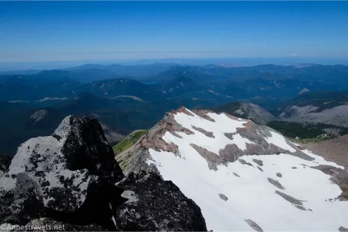
After Ho Rock, the path becomes sketchier for a short distance with fairly simple Class 3 scrambles up to the top of Cathedral Ridge and the end of the trail. Views from here stretch up to the top of Mt. Hood, down two valleys, and well into Washington. Spectacular!
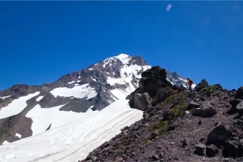
We ate a snack here, but one of my companions and I (yes, the same one who free-climbs rope-required canyons with me in Death Valley) decided we wanted to go a bit higher. So off we went on a Class 3 scramble down to the next saddle and then up Cathedral Ridge. We finally ended up on a high point only about 0.4 miles from the top of the McNeil Point Trail, but it was quite a Class 3 scramble and it took time to find our way and make sure we weren’t doing anything (too) dangerous. It would have been fun to go a little further, but the next highpoint on the ridgeline looked as though it would be difficult if not impossible to climb (maybe something out of Tolkien?) and we were already facing a 12.4 mile RT hike. So we took our pictures and set off back to where our other companion was chatting with locals about politics (or listening might be a better description).
On our way back down, we wanted to see the CCC warming hut. On our first visit, we had made it as far as the hut, so we thought it would be neat to see it when we could see the mountain, too. Somewhere along the way, we met a hiker who told us about a shortcut from the McNeil Point Shelter down to the Timberline Trail. It sounded simple, and I vaguely remembered seeing something about it online, so we tucked the knowledge into the back of our brains for later use.
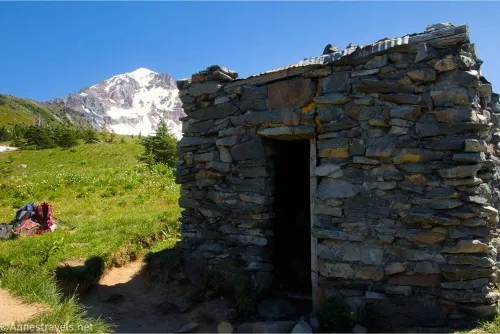
The warming hut explored briefly while marveling about what we couldn’t see while mist swathed the meadows, we were ready to follow the directions given by the hiker. A path leads behind the hut pretty much straight downhill. This is the shortcut. It passes through trees, scrambles down scree, drops over a ledge or two, and generally is a trail you wouldn’t want to follow if you’re not extremely sure of step, and even then, I was very thankful for hiking poles and worried anyway. But it cut about a mile off of our overall distance, and at that point, I was very thankful for a legal shortcut!
We arrived back down on the Timberline Trail, brushed off the dust of too much scree, turned left, and returned to the world of trail-abiding citizens. Back to the ridge-top viewpoint, as we had guessed, the view was much better in the afternoon.
Then we decided we’d gotten gypped on Bald Mountain, so we did the extra trek back over the Cutoff Trail and up Bald Mountain. We were right – the views and the wildflowers were amazing!
Round Trip Trail Length: I went 11.4 miles. You can easily make the hike shorter by going to Bald Mountain (approximately 3 miles), up to the first viewpoint (approximately 5.5 miles RT), or taking the shortcut trail up to the warming hut (roughly 9 miles RT).
Elevation Gain: 4,062ft. (3,922ft. to 7,266ft.) – this is from my entire hike; it would be considerably less if you didn’t climb up Cathedral Ridge.
Facilities: There might be a primitive restroom at the trailhead
Fees: $5/vehicle/day fee to recreate in Mount Hood National Forest. America the Beautiful National Park & Federal Lands Passes and Northwest Forest Passes are accepted.
Trail Notes: This hike has massive elevation gain, so be prepared for a harder-than-the-mileage suggests hike. Most people seem to do it as an overnight hike, but make sure you look up the regulations before setting up your tent on a meadow (which is not allowed, among other restrictions). Early in the season (before mid-July), snow can pose a significant hazard, so use care. Don’t climb up anything you won’t be able to climb back down. And while I did go beyond the end of the trail, I don’t recommend it unless you have ample experience bouldering off-trail.

Trail 
![]()
![]()
Road ![]()
![]()
Signs ![]()
Scenery
Would I go 100 miles out of my way for this?
Overall Rating: ![]()
GPS Coordinates for McNeil Point
TH (not accurate?): 45.4074440°, -121.7853000° (45°24.44664′, -121°47.11800′ / 45°24’26.7984″, -121°47’07.0800″) (3,976ft.) (0.0)
TH (likely more accurate): 45.4077870°, -121.7858770° (45°24.46722′, -121°47.15262′ / 45°24’28.0332″, -121°47’09.1572″) (3,944ft.) (0.0)
PCT: 45.4056150°, -121.7788700° (45°24.33690′, -121°46.73220′ / 45°24’20.2140″, -121°46’43.9320″) (4,329ft.) (0.55)
Timberline Trail: 45.4053470°, -121.7784290° (45°24.32082′, -121°46.70574′ / 45°24’19.2492″, -121°46’42.3444″) (4,337ft.) (0.58)
Cutoff Junction (S side): 45.4025770°, -121.7704570° (45°24.15462′, -121°46.22742′ / 45°24’09.2772″, -121°46’13.6452″) (4,332ft.) (1.39)
Cutoff Junction (N side): 45.4031990°, -121.7703180° (45°24.19194′, -121°46.21908′ / 45°24’11.5164″, -121°46’13.1448″) (4,330ft.) (1.45)
McGee Junction: 45.4037780°, -121.7684990° (45°24.22668′, -121°46.10994′ / 45°24’13.6008″, -121°46’06.5964″) (4,380ft.) (1.56)
View: 45.3987990°, -121.7499240° (45°23.92794′, -121°44.99544′ / 45°23’55.6764″, -121°44’59.7264″) (5,011ft.) (2.63)
Scramble Trail Junction: 45.3968460°, -121.7371730° (45°23.81076′, -121°44.23038′ / 45°23’48.6456″, -121°44’13.8228″) (5,332ft.) (3.38)
Mazama Junction: 45.4024460°, -121.7318800° (45°24.14676′, -121°43.91280′ / 45°24’08.8056″, -121°43’54.7680″) (5,617ft.) (4.04)

McNeil Point Junction: 45.4027280°, -121.7284650° (45°24.16368′, -121°43.70790′ / 45°24’09.8208″, -121°43’42.4740″) (5,742ft.) (4.38)
Viewpoint: 45.3990650°, -121.7274100° (45°23.94390′, -121°43.64460′ / 45°23’56.6340″, -121°43’38.6760″) (5,958ft.) (4.91)
Split for shelter vs. point: 45.3956620°, -121.7288660° (45°23.73972′, -121°43.73196′ / 45°23’44.3832″, -121°43’43.9176″) (6,124ft.) (5.2)
McNeil Point: 45.3907360°, -121.7222980° (45°23.44416′, -121°43.33788′ / 45°23’26.6496″, -121°43’20.2728″) (6,925ft.) (5.93)
Top of ridge: 45.3875630°, -121.7174710° (45°23.25378′, -121°43.04826′ / 45°23’15.2268″, -121°43’02.8956″) (7,262ft.) (6.36)
High vs. low trail junction: 45.3947450°, -121.7303590° (45°23.68470′, -121°43.82154′ / 45°23’41.0820″, -121°43’49.2924″) (6,173ft.) (7.44)
Stone shelter: 45.3954650°, -121.7320430° (45°23.72790′, -121°43.92258′ / 45°23’43.6740″, -121°43’55.3548″) (6,038ft.) (7.58)
Regain Trail (below scramble trail): 45.3968340°, -121.7372300° (45°23.81004′, -121°44.23380′ / 45°23’48.6024″, -121°44’14.0280″) (5,330ft.) (7.99)
Bald Mountain Junction: 45.4044870°, -121.7790560° (45°24.26922′, -121°46.74336′ / 45°24’16.1532″, -121°46’44.6016″) (4,371ft.) (10.80)
End: 45.4079010°, -121.7859370° (45°24.47406′, -121°47.15622′ / 45°24’28.4436″, -121°47’09.3732″) (3,945ft.) (11.39)
The gpx file for McNeil Point can be downloaded – please note that this and the GPS Coordinates are for reference only and should not be used as a sole resource when hiking this trail.
Download GPX File size: 135.2 KB Downloaded 254 times
(Note: I do my best to ensure that all downloads, the webpage, etc. are virus-free and accurate; however, I cannot be held responsible for any damage that might result, including but not limited to loss of data, damages to hardware, harm to users, from use of files, information, etc. from this website. Thanks!)
Getting to McNeil Point
It’s very difficult to describe the network of roads on the north side of Mount Hood, so I highly recommend putting the trailhead coordinates into a GPS with offline maps (Organic Maps is good). But I’ll also tell you how to get there from Portland.
Take I-84 to Exit 16. Turn onto NE238th Drive for 2.8 miles, then turn left onto NE Burnside Road for 0.7 miles. Continue straight onto US-26 for 27.1 miles. Turn left onto E Lolo Pass Road for 4.2 miles, then turn right onto Muddy Fork Road for 0.7 miles. Continue straight onto 1828 for 5.6 miles and straight for another 1.5 miles to the trailhead. The road continues beyond the trailhead, but it becomes rougher (the road is generally ok for most vehicles though there are a lot of potholes – like, a lot of potholes!) The parking area itself is small, and many people drive further down the road to park along it – which works, but be careful climbing out on the downhill side as it’s a very steep downhill!
Explore Mount Hood any time of year
Eitghty-five trails are featured in this book designed to help you adventure on and around Mount Hood through the seasons. Buy your copy here.