

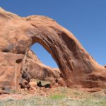
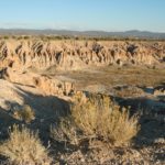
Fabulous views await those who go to Exclamation Point on the north rim of Black Canyon of the Gunnison
Black Canyon of the Gunnison’s north rim has got to be one of the weirdest national parks I’ve ever visited. Typically, national parks are crowded, have lots of services, have lots to do, and have lots of rules, which are strictly enforced. The North Rim of Black Canyon of the Gunnison is not crowded, has very few services (even the road is gravel, not paved), has a limited number of activities, and has very few rules, which are less than strictly enforced. For example, when we came into the park, we literally couldn’t figure out how to pay the $15 entrance fee (also good at the South Rim and is good for 7 days). It turned out that all of the fee envelopes were gone, and hadn’t been replaced yet! The small campground doubles as a picnic area, and the rangers are very helpful in telling you where you can camp for free outside of the park. And, one of the rangers told us that on a very busy day in the summer, he might get 70 visitors to the park. The rest of the time, there aren’t half as many visitors.
Beyond all of this, (and between the two of us; don’t tell anyone) the views are just plain better from the North Rim than from the South Rim. From the South Rim (which has many of the more typical services offered in national parks), I can recall one overlook that showed the river. This is because the South Rim tends to slope down to the canyon floor, while the North Rim is usually a straight drop to the canyon below. Thus, you can see the river from almost every viewpoint on the North Rim. I’ll tell more about the viewpoints in a few minutes.

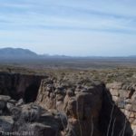
At the bottom of Long Draw: The views from the bottom of the canyon are amazing!
To get to the North Rim of Black Canyon of the Gunnison, take Colorado 92 to the town of Crawford. If you’re coming from the north (Hotchkiss), you’ll go through the town and around a lake or two. If you’re coming from the south (I-50 and Maher) you will come very close (if not pass) Crawford State Park, but will not go through the town of Crawford itself. (The road to Black Canyon is near the state park; I forget which is first). You will turn onto a road going west called “Black Canyon Road”. There are signs, so follow these. Continue to follow the signs past several ranches and other roads to the park itself. The last 6 of the 14 miles into the park are unpaved; however, the road is very good, and is easily transversed in a car. This road is closed in the winter, so check online for current conditions. The first thing in the park that you will come across is a fork in the road. The left fork goes to the Rim Drive, and the right fork goes to the ranger station and the campground. At the ranger station, you can pay your entrance fees and campground fees, get information, and get permits for inner canyon activities. You can also pay at the “entrance station” (self-pay board) slightly farther up the road, just before you enter the campground.
A free permit is required for all inner canyon activities, from hiking to the bottom to rock climbing (very, very difficult climbing, I hear), to overnight camping, etc. Generally, if you will be doing anything in the canyon itself, you need a permit. Fill out the form, submit the white part at the permit station located in the back left corner of the ranger station porch, keep the yellow copy with you at all times, and fill out the required information on the white board on the wall near the permit station. When you return from the canyon, submit the yellow copy in the permit station and erase your information from the white board. This is so that if you don’t make it back from your activities, the rangers can come find you. This should not be relied on, but is a service that the park uses to try and lessen fatalities in the canyon.

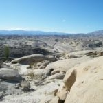
The view of the canyon from Kneeling Camel View. You can see the Kneeling Camel in the left part of the photo
So, what is there to do on the North Rim of Black Canyon? First of all, there is the Rim Drive. This is the left fork when you are coming into the park (straight if you’re coming from the ranger station/campground). Along this are several trails and overlooks that are worth doing. First is The Narrows View, which unfortunately I didn’t stop at, so although I’ve heard it’s really nice, you’ll have to check it out for yourself. The Balanced Rock View is also nice, and looks over one of the narrowest parts of the canyon. Don’t be fooled, though: you are also overlooking Long Draw, a trail down to the river, but the trail isn’t half as flat as it looks from the overlook! In reality it is very, very steep (more on that later).
Big Island View and Island Peaks View are also very nice, and offer great views into the canyon and across to the South Rim. Kneeling Camel View is also very nice, with the rock over on the left that looks like a camel kneeling down. If you want another really great view, go down to the end of the road and take the social trail across from the restroom to the canyon edge. Here there are no railings (before this, there was at least something in most places to keep you from falling over the edge at viewpoints, although not much in other places), but you get a great view of the other side of the kneeling camel, and awesome views up and down the canyon. Remember, never drop anything over the edge, because there may be hikers below you, and even a small stone could be fatal.

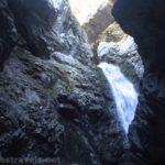
A sort way down Long Draw
There is also some hiking on the Rim Drive. The Dead Horse Trail leaves the road near Kneeling Camel View. I didn’t take this trail, but it is a route that can be taken with horses. Also, two of the three “trails” down into the canyon depart from the Rim Drive: Slide Draw and Long Draw. Slide Draw is not really recommended by the park service simply because it is loose rock (scree) all the way to the bottom, and is therefore the most potentially dangerous route. Still, if you plan to take this route, park at the Kneeling Camel View and walk east until you come to the top of the draw. Follow the draw approximately 1.5 miles to the river, being careful of the loose rock and poor footing. Also, be aware that this route requires a 30 ft. downward climb to start the route.
I actually hiked (or perhaps scrambled would be a better word) Long Draw, so hopefully I can be more helpful in describing this route down to the edge of the river. Park at Balanced Rock Overlook, and walk northeast along the road (in other words, continue along the road) until you come to the top of the draw. From here, a steep path leads down into the canyon. At first, you will want to stay to your right as you follow the rock face through bushes and low-hanging trees down the first ¼ mile or so of the draw (the hike is approximately 2 miles round trip). Then you will come to less over-hanging foliage and more good-sized rocks. These can make for dangerous footing, so be careful where you place your feet. If you accidentally knock a rock loose, yell “Rock!” so that hikers below you know to get out of the way. (This saved a few of us from getting hit!) There are a few places where you must scramble down fairly good-sized drop-offs, but there are other rocks in place to help you get back up. The loose rock continues virtually all the way down to the river, although there are patches of foliate along the way, and the last 200 ft. or so has trees and bushes with several trails going through it. This last section also has the only poison ivy I saw in the entire draw. The brochure I read said that it could be 5 ft. high, but I only saw specimens that were 3 or so ft. high, and the plants were fairly easily navigated around. We got to the river without touching it, and were very thankful that there wasn’t more, as several in our group claims that they can get poisoned just by looking at it. The ivy itself is a much darker green than the rest of the foliage found in the draw, has spade (as in a deck of cards) shaped leaves, and the leaves come in groups of three. There were also little clusters of round balls underneath some of the leaves when we were there. The entire route is very steep and slippery, and should not be attempted by anyone who doesn’t have a sense of adventure and/or isn’t in good shape. As a said above, don’t let the view of the draw from Balanced Rock View deceive you!

The Gunnison River rushes through the canyon at the bottom of Long Draw
The view from the bottom is absolutely spectacular: this is one of the narrowest parts of the canyon, and the Gunnison River roars through in a display of green water and boulders. Looking up is also awesome, as the canyon walls seem to tower above you. I’ve always heard that the views from inside the canyon are better than those from the rim. Now I believe them.
The third route down into the canyon starts from the ranger station. S.O.B. Draw is known as the easiest route down into the canyon, but it is also known for its abundant poison ivy. It’s 1.75 miles one way, though, which makes it the longest decent into the canyon. You can park at the ranger station, or at the information board (“entrance station”) just outside of the campground. The route begins at an access ladder along the fence just to the east of the campground. There are also small drop-off (similar to in Long Draw) to climb down.
In terms of rim hiking, there is the short Chasm View Nature Trail which starts from the campground. I hear this has nice views, but we never got around to hiking it. However, we did end up hiking 3 miles out to Exclamation Point along the North Vista Trail.
The trail starts at the ranger station, and is fairly flat at least as far as Exclamation Point. In all honesty, this is probably the best view we got of the canyon. There are no railings or guardrails, but you can see all the way down the canyon, and the river as it winds its way along the bottom. Admittedly, it is absolutely stunning, and is either enough to take your breath away, or to make you exclaim; thus the name. You can continue up the North Vista Trail for another ½ mile or so to the top of Green Mountain, but we didn’t bother, figuring that the view from the rim would probably be better than from the top of a mountain. Maybe we were wrong, and, if we are, tell me and we’ll hike it next time!
Fees: $15 to enter the park, good for 7 days, also accepted at South Rim. Federal Lands Passes, Golden Age, and Golden Access Passes are also accepted.
Road 
![]()
Signs ![]()
Scenery
Overall Rating: 
This Week’s Featured Product!
Let your jaw drop with some of the most scenic hikes in Colorado in this book!
Pingback: Anne's Travels » Chasm View Trail – Short Trail, Wonderful Views!
Pingback: 12 Trails that Require Hands & Knees, River Crossings, and Other Adventures