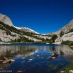
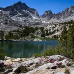
Blue Lake above Lake Sabrina in the John Muir Wilderness of California is probably best known as a backpacking destination. However, it makes a great dayhike and was one of the prettiest mid-length hike of the High Sierra trails I took last summer. The setting of the lake is spectacular; the lake truly is blue, and the cliffs beyond are jagged and breathtaking. Add to this some flowers, and you have a fantastic place to enjoy the scenery for a few hours before continuing up to more lakes or back to the trailhead!
Quick Stats

The Lake Sabrina to Blue Lake Trailhead is just below the Lake Sabrina dam. I arrived very early on a Sunday morning and took one of the few open parking spaces – more parking is available beyond the dam. It was still a short, steep trek up to the sign marking the trailhead.

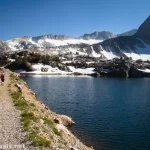
The trail is wide and fairly easy at first, though you’ll be climbing for most of the trail. Views are excellent over Lake Sabrina. I especially loved the views of the waterfalls above the lake.

At mile 0.8, the trail enters the John Muir Wilderness. A friend had hiked the John Muir Trail the year before, and her pictures were amazing, so I was thrilled to finally visit the wilderness, too!

Half a mile later, pass the junction for the trail that would take you over the mountain to George Lake on the left. Continue right here on the hillside high above Lake Sabrina.

At the end of the lake, the trail begins to climb in earnest. It’s never terribly steep, but it’s never very flat, either. As you climb higher, views are very good to the mountains around Lake Sabrina. I especially liked the red peaks that appeared – these are in the same valley as Piute Pass, where we hiked the next day.

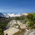
The path enters the forest, crosses a few streams, and works its way up stairs to an area of boulders. Above this, where the trail zigzags on a rock face, a viewpoint is a nice place to rest about mile 2.0.

Keep walking upward through the trees as the trail twists and turns with the landscape. Then, almost 3 miles from the trailhead, the path leads you to a trampled area with trails leading down to a river crossing. This is the outlet of Blue Lake, and the lake, itself is nearby.

I crossed over the outlet (not terribly hard on the last day of June) and headed up the west side of the lake. There were many places where people camp – I gather this is a very popular backpacking destination (permit required), both for beginners and for those who want to hike further up the trail over several days.

We stopped for lunch on the rocks on the west shore. The views were fantastic!

My thought had been to hike up to Midnight Lake (or at least Dingleberry Lake), but my group was pretty tired from a late-night flight and then hiking the 20 Lakes Basin the day before. We also knew we had a very long trek the next day up at Piute Pass, so it was a group decision to rest and enjoy the views at Blue Lake before heading back down. Maybe someday we’ll be back – the views are worth it, for sure!

Round Trip Trail Length: I went 6.5 miles
Elevation Gain: 1,854ft. (9,078ft. to 10,424ft.)
Facilities: Restrooms near the Lake Sabrina dam; I hear there is also a campground in the area as well as another campground or two down the road.
Fees: None

Trail Notes: Fishing in Blue Lake is allowed; I hear it has a good stock of rainbow and brook trout among others. The trail is steep, so don’t think this is a simple stroll in the park. The norm is views, though there are some forested sections of the path. I’d bring along sunglasses – the sun reflecting off the rocks is bright!

Trail 
![]()
![]()
Road ![]()
Signs ![]()
Scenery
Would I go 100 miles out of my way for this?
Overall Rating: ![]()

GPS Coordinates for Blue Lake from Lake Sabrina
Lake Sabrina TH: 37.2135780°, -118.6099910° (37°12.81468′, -118°36.59946′ / 37°12’48.8808″, -118°36’35.9676″) (9,081ft.) (0.0)
Enter John Muir Wilderness: 37.2060310°, -118.6165480° (37°12.36186′, -118°36.99288′ / 37°12’21.7116″, -118°36’59.5728″) (9,185ft.) (0.79)
Lake George Junction: 37.1998330°, -118.6167650° (37°11.98998′, -118°37.00590′ / 37°11’59.3988″, -118°37’00.3540″) (9,417ft.) (1.29)

Blue Lake: 37.1877260°, -118.6210210° (37°11.26356′, -118°37.26126′ / 37°11’15.8136″, -118°37’15.6756″) (10,393ft.) (2.99)
Viewpoint: 37.1850830°, -118.6206350° (37°11.10498′, -118°37.23810′ / 37°11’06.2988″, -118°37’14.2860″) (10,405ft.) (3.25)
End: 37.2136760°, -118.6100510° (37°12.82056′, -118°36.60306′ / 37°12’49.2336″, -118°36’36.1836″) (9,076ft.) (6.50)

The gpx file for Blue Lake from Lake Sabrina can be downloaded – please note that this and the GPS Coordinates are for reference only and should not be used as a sole resource when hiking this trail.
Download GPX File size: 86.4 KB Downloaded 192 times
(Note: I do my best to ensure that all downloads, the webpage, etc. are virus-free and accurate; however, I cannot be held responsible for any damage that might result, including but not limited to loss of data, damages to hardware, harm to users, from use of files, information, etc. from this website. Thanks!)

Getting to the Lake Sabrina and Blue Lake Trailhead
From the town of Bishop, turn west onto CA-168 (W Line Street). Continue straight for 18.7 miles to the trailhead on the left. Note: There is basically no parking at the trailhead. Spaces have been carved out of the woods just downhill from the trailhead, or you can park up beyond the dam and walk back to the trailhead (adds about 0.3 miles each way).
Today’s Featured Product!
Dozens of trails and routes are sure to inspire in this guide to the High Sierra. From lowland hikes to mountain peaks, not to mention waterfalls, lakes, and more, it has something for everyone. Buy your copy here.