

There are two Mono Passes in California, and they happen to be only about 40 miles apart. I’m sure the one on the eastern edge of Yosemite National Park is very nice, but I’m also sure it can’t compare with the Mono Pass, 40 miles south, below Mt. Starr and accessed from the Mosquito Flat Trailhead.
Mono Pass Trail – Quick Stats
(Affiliate links are present on this page.)
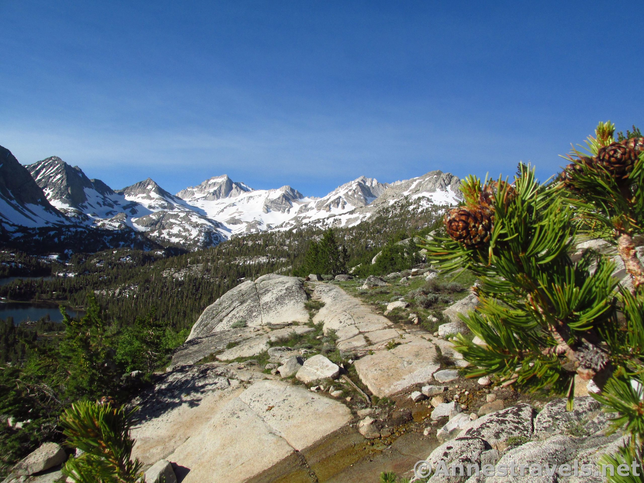
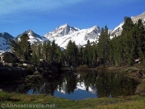
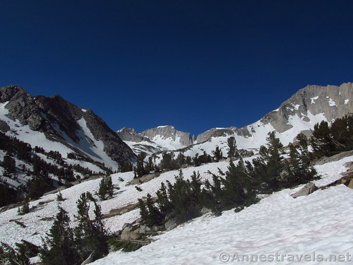
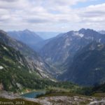
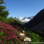
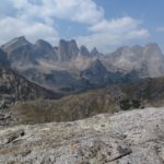
The en route views are out-of-this-world spectacular of lakes and mountain peaks – I couldn’t decide if I was in Alaska / Northern Canada, the Canadian Rockies, the Maroon Bells, or the Sierras – and the views from the Pass are little less epic, especially when the peaks are still snow-covered. Then again, if the peaks have snow, the pass might, too, since it’s just over 12,000ft. above sea level. But it’s worth the risk of possible snow; it is one of the most beautiful views I have seen in all my travels.
The trail begins at Mosquito Flats (aptly named – watching people get out of their cars, stretch, walk away a dozen paces, and then dash back to their vehicles slapping themselves was delightfully guilty entertainment!) south of Mammoth Lakes and north of Bishop, off of US-395. I’ve heard that this is the Sierras’ highest trailhead, which is good, because you’ll be hiking all the way up to 12,000ft.!
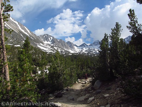
Hike up past the restrooms (don’t cross the bridge) and follow the wide trail upward along the stream. It was rushing pretty well when we hiked in early July after a season with 200% snowpack, and those fishing looked to be having a good time (they knew what they were doing and sprayed each other down with bug spray before they were half out of their pickup!)
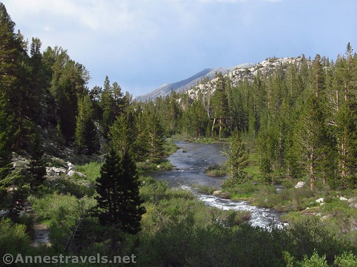
Enter the John Muir Wilderness at mile 0.25; at 0.5 miles you’ll come to the first trail junction. Turn right toward Mono Pass and Ruby Lake, away from the Little Lakes Basin and Morgan Pass (which I suspect would also be very, very nice).
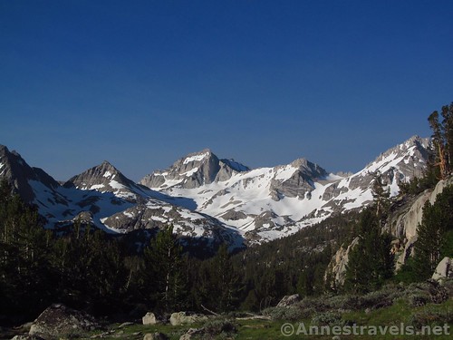
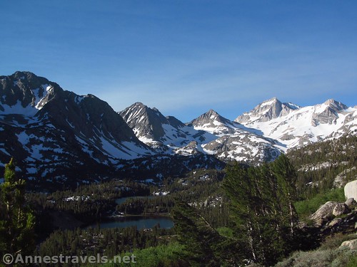
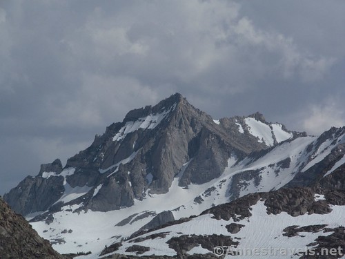
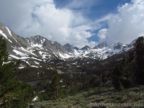
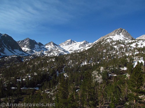
After this the views, which have been increasing steadily, become really epic. The Little Lakes Basin is below you, so there are lots of alpine lakes and tarns, while above the peaks in front of and surrounding Mt. Mills, Mt. Abbot, and Mt. Dade look like something out of a postcard. It is so totally, completely, outstandingly, amazingly, breath-takingly beautiful!
While researching trails in the Sierras, I had read three separate bloggers claiming Mono Pass as the most beautiful view they had ever seen. While it might not be the most beautiful thing I’ve seen, it is definitely one of the most beautiful, up there with views from Sahale Arm and of the Cirque of Towers!
Keep hiking upward. A number of very nice viewpoints would make a great turn-around place for a shorter hike (3.5 mile RT or less).
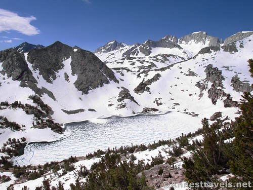
The trail finally turns its back on the view just before the junction for the trail to Ruby Lake. It wouldn’t be a long detour (likely less than a mile RT) if you decide you want to visit it; we didn’t, in part because it was totally iced over and therefore was much more slightly from above.
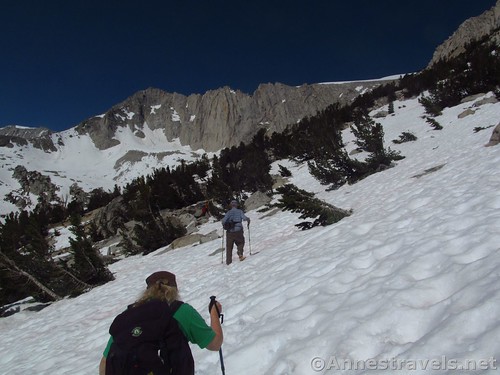
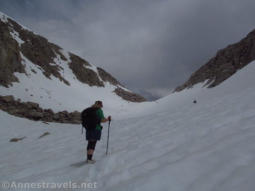
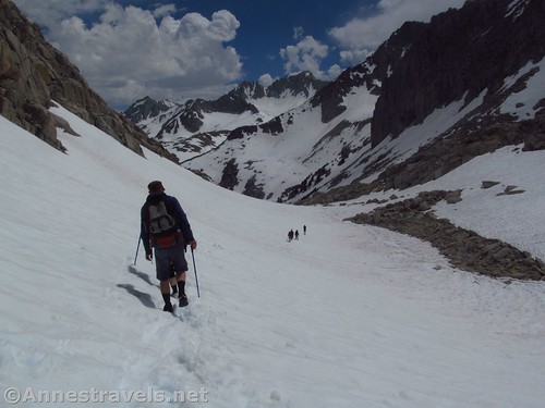
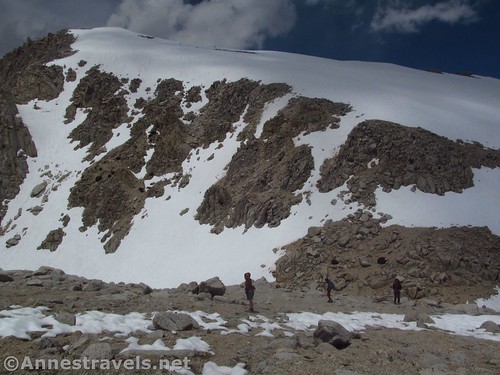
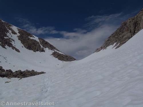
And above it you will soon be. The trail almost immediately begins switchbacking up the steep (very steep) hillside of Mt. Starr. However, this also happened to be the snowline. So instead of switchbacking, we went pretty much straight up. I don’t recommend the route we took particularly; it was where we ended up. One of my group members found a much better way down, closer to Ruby Lake and with less snow.
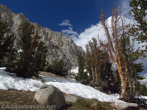
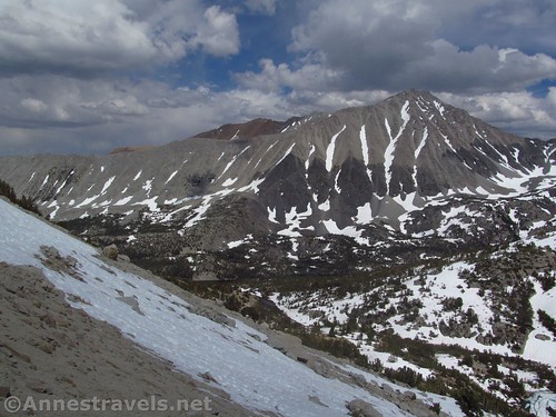
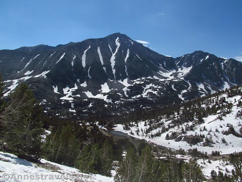
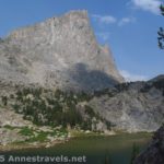
At last, high above Ruby Lake, the trail makes its way along the ridgeline (the mountain directly across the valley, very bulky on the other side of the Little Lakes Basin, is Mt. Morgan, FYI). We found the trail again and followed it over to a very nice viewpoint over Ruby Lake and the unnamed, but breathtakingly beautiful, peaks surrounding the lake.
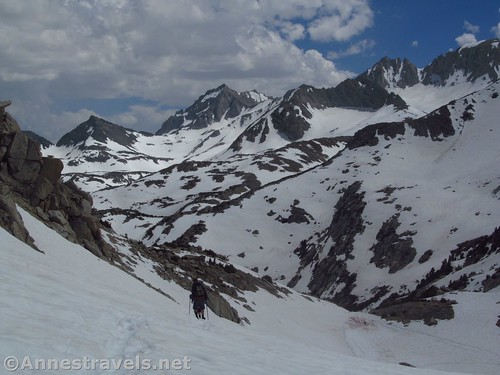
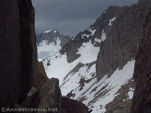
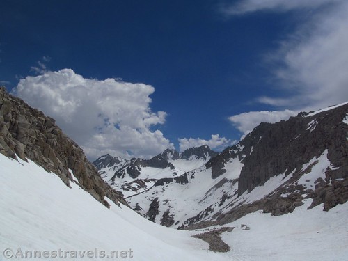
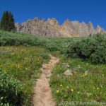
Now the trail really does turn its back on the view as it ascends between Mt. Star (right / east) and an unnamed ridgeline (left / west) 0.75 miles or so to the pass. Looking back, the unnamed-but-breathtakingly-beautiful-peaks are still visible.
We lost the trail again on the way up to the pass, so while the topo maps show the trail going up the western side of the pass, we definitely followed footprints up the eastern side (joking that mountain goats had worn hiking boots to turn unwary hikers off the proper course). It wasn’t anywhere near as hard as climbing the non-switchbacks up Mt. Starr.
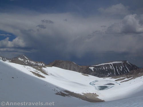
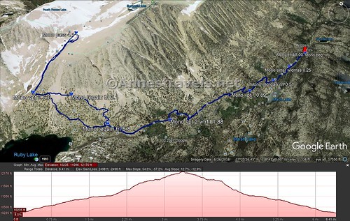
We arrived at the high point of Mono Pass at about mile 4.1 on my GPS, though with the snow, it’s hard to say if that’s accurate.
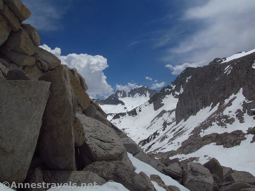
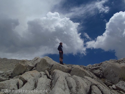
Right about the time we arrived at 12,000ft., thunder began to rumble over the mountains behind us. Oh, great. It’s the highest we’ve been on the entire trip, and here comes a thunderstorm.
One of my group members found a large section of rocks and boulders that weren’t covered in snow. We hunkered down under some of them and waited out the storm, eating Oreos and cheesesticks, taking pictures of the storm, watching the hail and snow fall, and thinking how very much it reminded us all of Elijah in the cave…
By the time the skies began to clear close to an hour later, we were ready to go. So instead of climbing Mt. Starr, or the unnamed ridge to the west, or even going down to Summit Lake, which is just over the crest of Mono Pass (it was frozen, anyway), we headed back down.
Overall we hiked almost exactly 8 miles. I’ve read elsewhere it’s only 7 miles RT to Mono Pass. Either is close enough for me; the views make it worth hiking!
Round Trip Trail Length: 7+ miles, depending on snow conditions, how far you go, etc.
Net Elevation Change: 1,809ft. (10,214ft. at the trailhead to 12,023ft. in Mono Pass)
Facilities: Restrooms. A very nice picnic area can be found at the SnoPark a couple miles below the trailhead, and there is also campgrounds along the road.
Fees: None
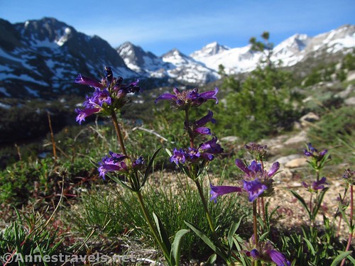
Trail Notes: The view is one of the best I have ever seen in the 48 contiguous US states and several Canadian provinces. You can shorten the trail to 3.5 miles or less by only hiking up to see the views over the Little Lakes Basin, or to about 6.5 miles by only going up to the viewpoint over Ruby Lake. I don’t recommend hiking the trail when snowcovered, but the snow on the peaks is beautiful! Make sure you bring bug spray – the mosquitos are horrible in the parking area, gradually thinning the higher you go.
Trail 
![]()
![]()
Road ![]()
Signs
Scenery
Would I go 100 miles out of my way for this?
Overall Rating: 
Key GPS Coordinates
Trailhead: 37.4351250°N, -118.7470611°W (37°26’6.45″N, -118°44’49.42″W / 37°26.10750’N, -118°44.82367’W) (10,214ft.) (0.0; ended 8.00)
Enter John Muir Wilderness: 37.4320639°N, -118.7491528°W (37°25’55.43″N, -118°44’56.95″W / 37°25.92383’N, -118°44.94917’W) (10,273ft.) (0.25)
Mono Pass / Morgan Pass Junction: 37.4290806°N, -118.7509833°W (37°25’44.69″N, -118°45’3.54″W / 37°25.74483’N, -118°45.05900’W) (10,411ft.) (0.51)
Viewpoint #1: 37.4266722°N, -118.7534500°W (37°25’36.02″N, -118°45’12.42″W / 37°25.60033’N, -118°45.20700’W) (10,554ft.) (0.89)
Viewpoint #2 / Waterfall: 37.4206028°N, -118.7603083°W (37°25’14.17″N, -118°45’37.11″W / 37°25.23617’N, -118°45.61850’W) (10,966ft.) (1.88)
Ruby Lake Trail Junction: 37.4186028°N, -118.7643944°W (37°25’6.97″N, -118°45’51.82″W / 37°25.11617’N, -118°45.86367’W) (11,034ft.) (2.28)
Regain Trail high above Ruby Lake: 37.4194861°N, -118.7695278°W (37°25’10.15″N, -118°46’10.30″W / 37°25.16917’N, -118°46.17167’W) (11,599ft.) (3.1)
Mono Pass: 37.4252167°N, -118.7727750°W (37°25’30.78″N, -118°46’21.99″W / 37°25.51300’N, -118°46.36650’W) (12,023ft.) (Arrived 4.1, left 4.3)
Viewpoint #3 (overlooking Ruby Lake; mileage is coming from Mono Pass): 37.4185806°N, -118.7727167°W (37°25’6.89″N, -118°46’21.78″W / 37°25.11483’N, -118°46.36300’W) (11,744ft.) (5.0)
Regain trail: 37.4186750°N, -118.7656167°W (37°25’7.23″N, -118°45’56.22″W / 37°25.12050’N, -118°45.93700’W) (11,144ft.) (5.8)
The gpx file for Linkins Lake can be downloaded – please note that this and the GPS Coordinates are for reference only and should not be used as a sole resource when hiking this trail.
File size: 206.6 KB Downloaded 0 times
(Note: I do my best to ensure that all downloads, the webpage, etc. are virus-free and accurate; however, I cannot be held responsible for any damage that might result, including but not limited to loss of data, damages to hardware, harm to users, from use of files, information, etc. from this website. Thanks!)
Getting to the Mosquito Flat Trailhead/Mono Pass Trailhead
From Bishop, CA, drive north on US-395N for 21 miles. Turn left onto Rock Creek Road, following signs for Tom’s Place, Crowley Lake Drive, and Rock Creek Lake. Follow the road uphill 10.5 miles to its end at the Mosquito Flats Trailhead.
From Lee Vining (where the Tioga Pass Road meets US-395), travel south on US-395S 40 miles, almost 15 miles south of the exit for Mammoth Lakes and Little Devils Tower. Turn right on Rock Creek Road, following signs for Tom’s Place, Crowley Lake Drive, and Rock Creek Lake. Follow the road uphill 10.5 miles to its end at the Mosquito Flats Trailhead.
Zoom map out to browse nearby hikes & places of interest
This Week’s Featured Product!
Want more trails in the Sierras? Check out this guide with almost 150 day hikes and backpacking routes.

One response to “Mono Pass: Totally Beautiful!”
[…] Yes, that really is the Mono Pass Trail! […]