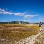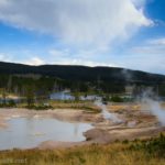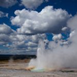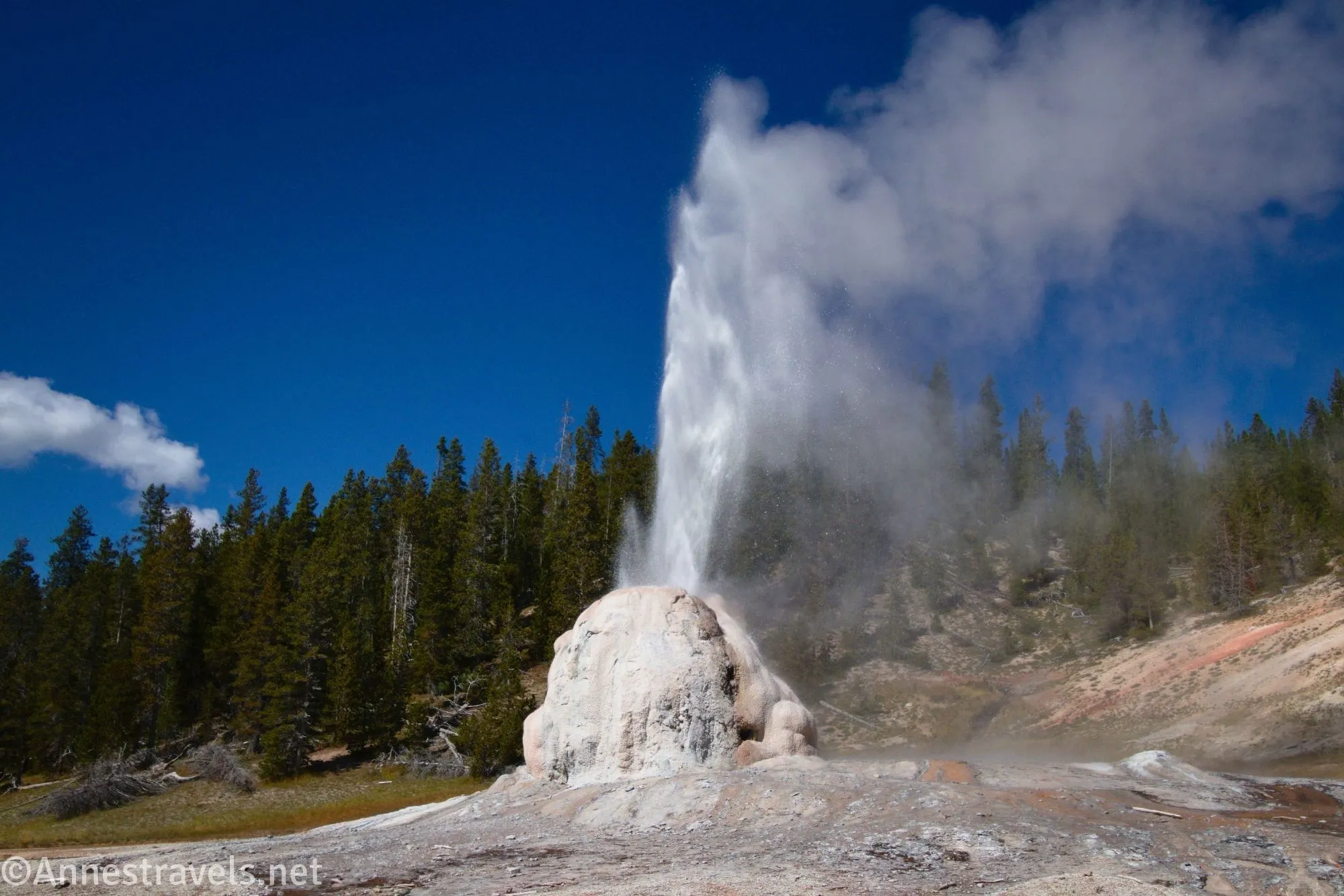
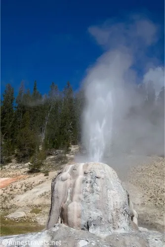
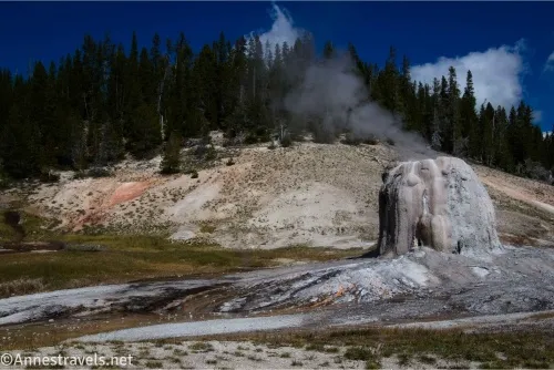
Lone Star Geyser is one of the famous “hidden” geysers in Yellowstone National Park. Close to the Old Faithful area, yet on its own trail with its own trailhead away from the boardwalks, it’s a great hike (or bike) that’s also mostly flat and (almost) easy. The geyser itself can be quite impressive. Now, the day I visited, Lone Star Geyser decided to give an extra special show in the morning and then be only halfhearted in the afternoon (when I showed up), but that’s an excuse to go back… right?
Quick Stats
The times for the geyser eruptions are often posted at the trailhead, so you’ll know if you just missed one or if you need to hurry to catch the next one. Even if you miss one, it typically erupts every 3 hours, so you won’t have to wait too terribly long for another explosion of superheated water.
Lone Star Geyser tends to gurgle and spurt water for 20-30 minutes before the true eruption. So don’t leave after the first gush of water – there’s more to come!
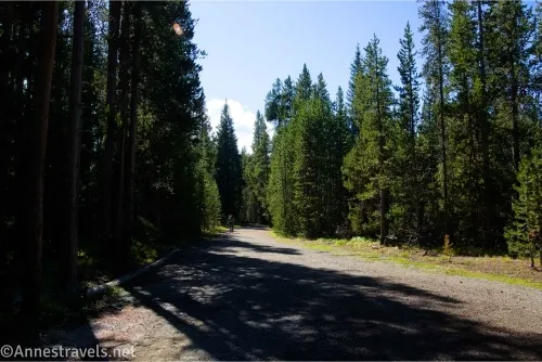
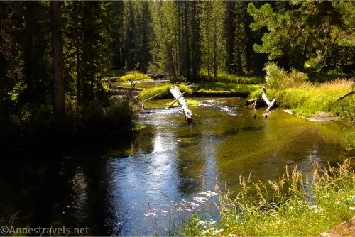
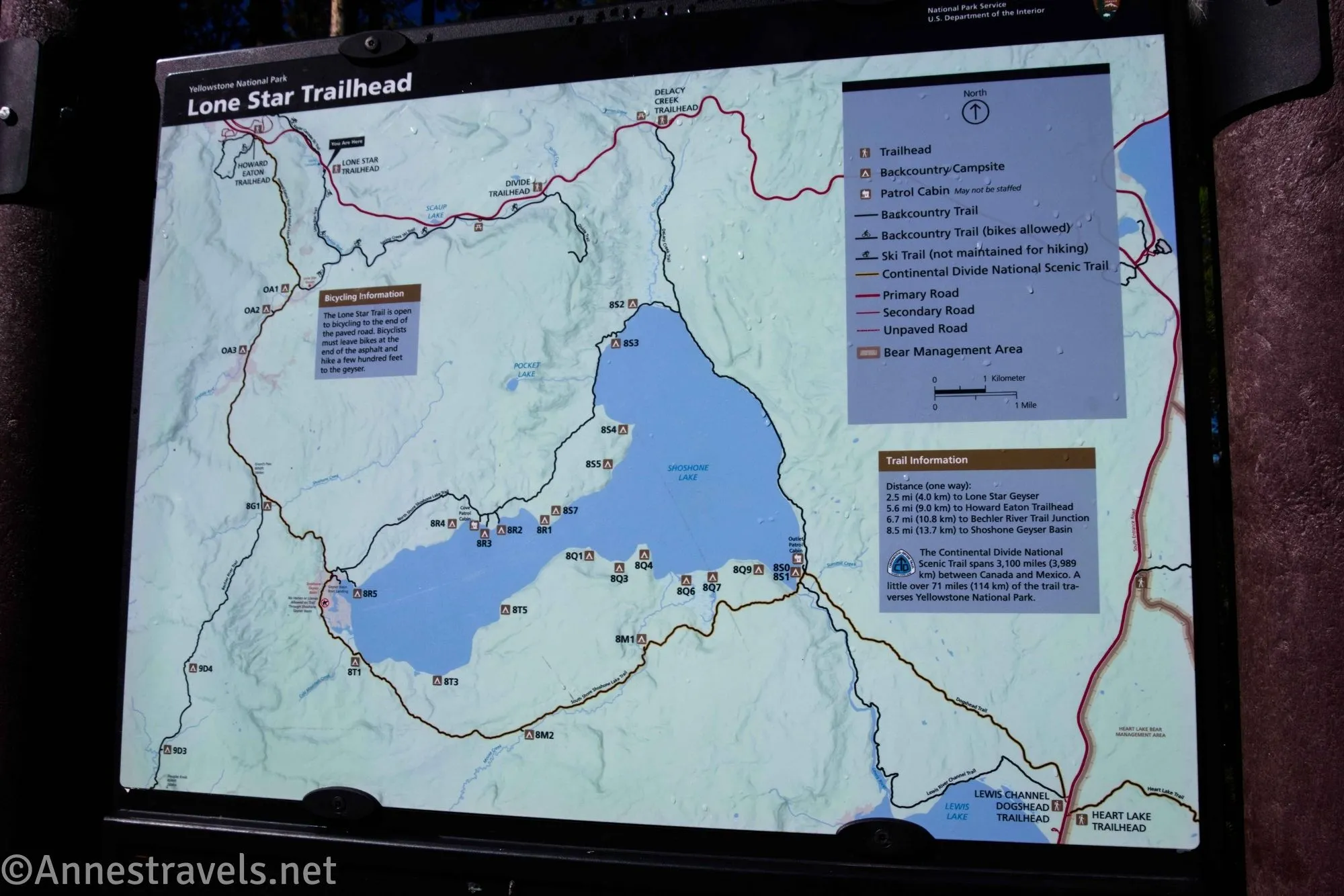
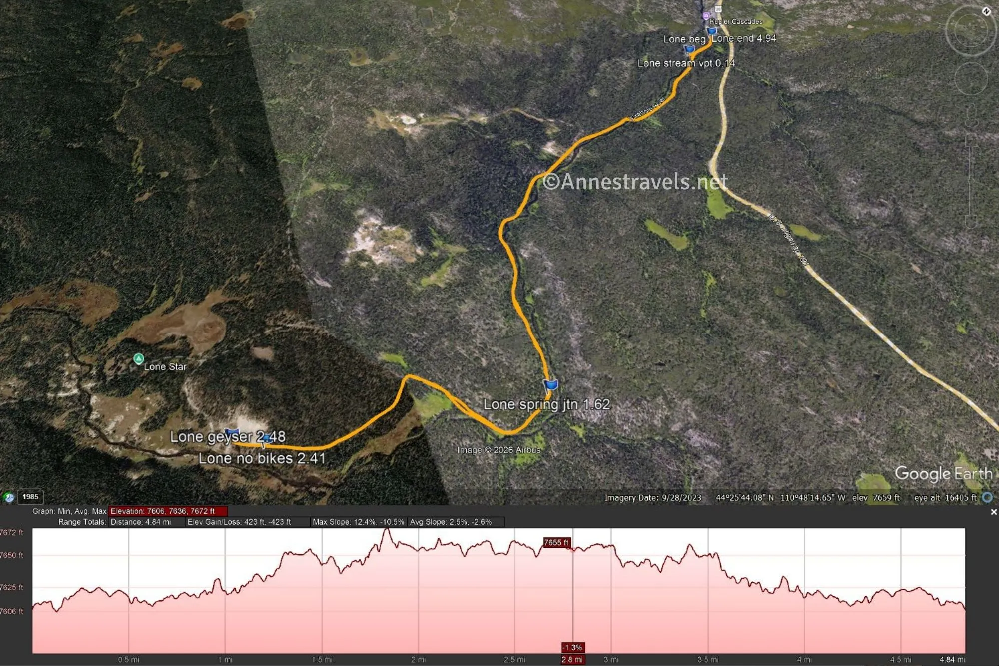
0.0 Lone Star Geyser Trailhead (7,595ft.). Head down the obvious old road behind the gate. The path is paved. After a tenth of a mile, an overlook on the right allows views of the Firehole River. Continue up the road in the shade of the trees. The grade is relatively flat. (44.4444300°, -110.8045330°)
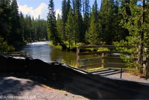
1.6 Spring Creek Trail Junction on left (7,631ft.). Continue right on the paved path. (44.4255390°, -110.7974110°)
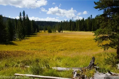
2.4 Bike rack (7,650ft.). This is the end of the paved path; bicycles are not allowed beyond this point, but there is a bike rack available. Continue straight on foot on the dirt trail toward Lone Star Geyser. (44.4187390°, -110.8051500°)
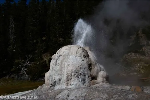
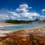
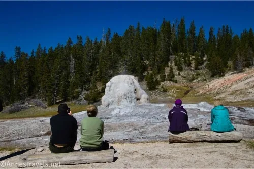
2.5 Lone Star Geyser Viewing Area (7,645ft.). A trail register nearby has a pad of paper where volunteers write down the history of eruptions and predictions for the next eruption. (Often quite accurate.) A few logs have been placed both near the geyser and in the shade of nearby trees to ease tired feet while waiting for the next eruption. After you’ve seen the geyser erupt, return the way you came. (44.4181900°, -110.8064530°)
Round Trip Trail Length: I went 4.9 miles, including some dashing around the viewing area to get different angles on the geyser, but it felt to me like closer to 3 miles because of the lack of a serious grade.
Elevation Gain: 423ft. (7,606ft. to 7,672ft.)
Facilities: Vault toilet at the trailhead
Fees: $35/vehicle, valid 7 days. America the Beautiful National Parks & Federal Public Lands Passes and Yellowstone Annual Passes are accepted.
Trail Notes: Lone Star Geyser erupts about every 3 hours; helpful visitors give the time of the last eruption at the trailhead register, so you can check and calculate the approximate time of the next eruption. (If you need to waste some time, Kepler Cascades are right next door, or you could drive down to Black Basin for an hour.) I’ve heard that the parking area (being tucked out of sight of the main road) has at times been a target for thieves. An easy way to avoid this is to park in the Kepler Cascades parking lot, which is visible from the road and right next door to the trailhead. Remember a bike lock if you bring bikes, as the end of the road is still a short distance from the geyser viewing area. “Lone Star” – from what I can tell – is a reference to the fact that the geyser is the “star” of the show, yet tucked away from the rest of the geothermal areas. If you visit on a sunny day in the morning, the geyser sometimes makes lovely rainbows with its fine mist.
Trail 
Road ![]()
Signs ![]()
Scenery ![]()
![]()
![]()
Would I go 100 miles out of my way for this? ![]()
![]()
Overall Rating: 
![]()
GPS Coordinates for Lone Star Geyser
TH: 44.4444300°, -110.8045330° (44°26.66580′, -110°48.27198′ / 44°26’39.9480″, -110°48’16.3188″) (7,595ft.) (0.0)
Stream viewpoint: 44.4427050°, -110.8046820° (44°26.56230′, -110°48.28092′ / 44°26’33.7380″, -110°48’16.8552″) (7,587ft.) (0.14)
Spring Creek Junction: 44.4255390°, -110.7974110° (44°25.53234′, -110°47.84466′ / 44°25’31.9404″, -110°47’50.6796″) (7,631ft.) (1.62)
Bike rack: 44.4187390°, -110.8051500° (44°25.12434′, -110°48.30900′ / 44°25’07.4604″, -110°48’18.5400″) (7,650ft.) (2.41)
Lone Star Geyser: 44.4181900°, -110.8064530° (44°25.09140′, -110°48.38718′ / 44°25’05.4840″, -110°48’23.2308″) (7,645ft.) (2.48)
End at TH: 44.4444550°, -110.8045620° (44°26.66730′, -110°48.27372′ / 44°26’40.0380″, -110°48’16.4232″) (7,594ft.) (4.94)
The gpx file for Lone Star Geyser can be downloaded – please note that this and the GPS Coordinates are for reference only and should not be used as a sole resource when hiking this trail.
Download GPX File size: 62.2 KB Downloaded 0 times
(Note: I do my best to ensure that all downloads, the webpage, etc. are virus-free and accurate; however, I cannot be held responsible for any damage that might result, including but not limited to loss of data, damages to hardware, harm to users, from use of files, information, etc. from this website. Thanks!)
Getting to the Lone Star Geyser Parking Area
From the Old Faithful exists, continue south on the main park road (US-89) toward West Thumb for 2.5 miles. Turn right into the unassuming access road for the parking lot just after Kepler Cascades – a sign does say “Lone Star,” but the actual driveway is a little further down the road beside the sign about no RVs or trailers. The parking area is shaded and secluded by trees, making it an easy target for break-ins. If you’re concerned, park out by the road (there is a wide spot that allows for some parking) or in the Kepler Cascades lot.
From West Thumb, take US-89 toward Old Faithful. After 15 miles, turn left into the unassuming access road for the parking lot just after the gates that can be closed – a sign on the right does say “Lone Star,” but the actual driveway is a little further down the road beside the sign about no RVs or trailers. The parking area is shaded and secluded by trees, making it an easy target for break-ins. If you’re concerned, park out by the road (there is a wide spot that allows for some parking) or in the Kepler Cascades lot.
Easy Hikes in Yellowstone National Park
The name of the book says it all – the best easy day hikes in Yellowstone National Park! With nearly 30 hikes to choose from, there’s a lot of variety within its pages. Buy your copy here.

Note: This post contains affiliate links. If you click a link and purchase something, I may get a small commission – there is no extra cost for you.