
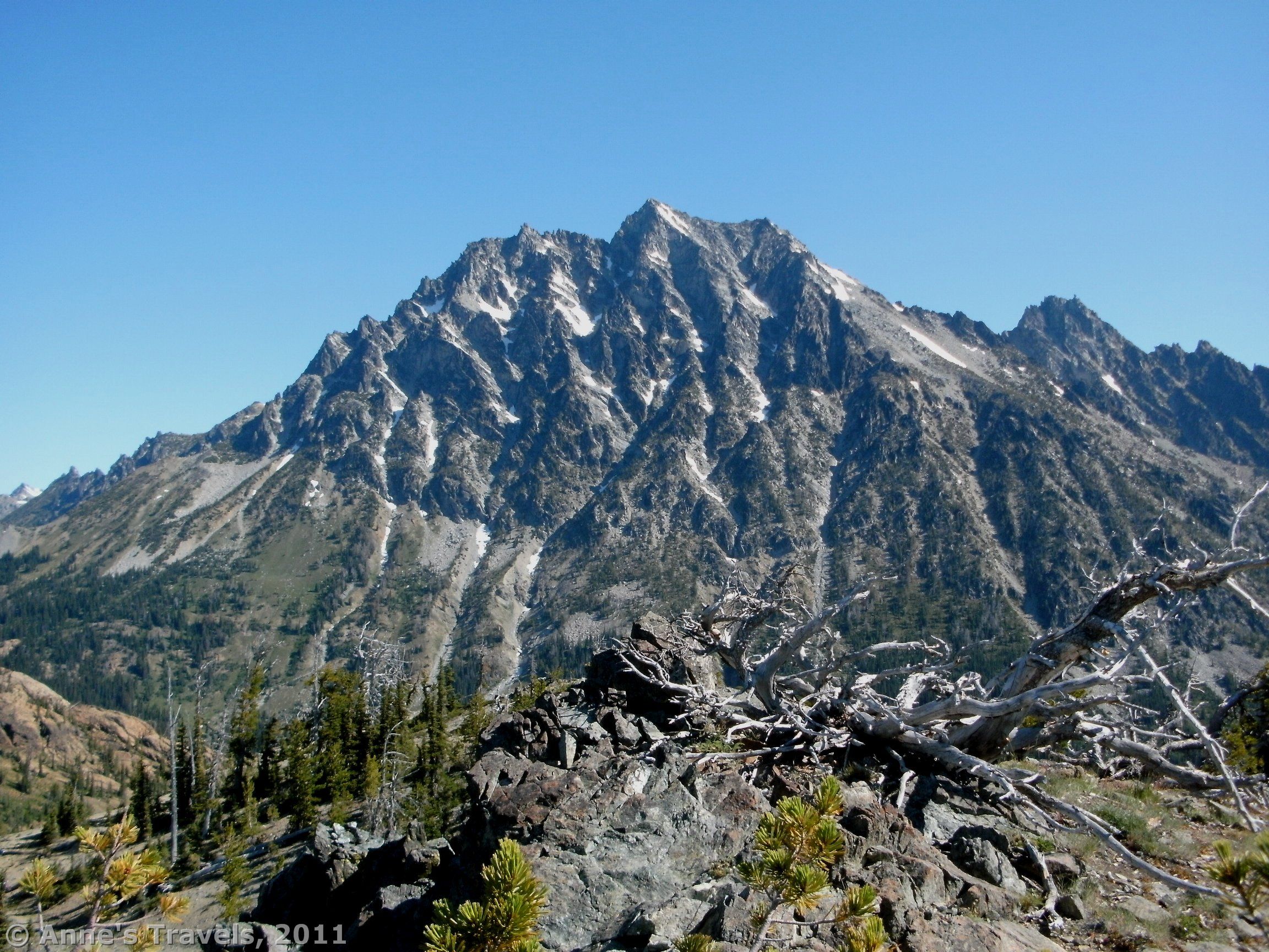

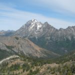
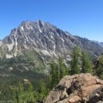
Mt. Stewart has got to be one of the prettiest mountains in the Teanaway area. It seems to be visible from just about any viewpoint in the area, and it gives you a reference point: “Oh, there’s Mt. Stewart again!” However, the best view I ever got of the mountain was from Longs Pass, just to the west of the mountain. From the pass you can get up close and personal with Mt. Stewart, as it’s right across the valley. In fact, it would be hard to get closer without actually being on the mountain! The views are stunning, and the trail is only about 6 miles round trip.
(Affiliate links are present on this page.)
Directions
The Longs Pass trailhead is the same as the one for the famed (for some reason) Ingalls Pass/Ingalls Lake. (I hiked to Ingalls Pass later in the day; I wouldn’t bother unless you’re going beyond to Ingalls Lake. The view isn’t very good compared to Longs Pass.) To get to this trailhead, from I-90 take exit 85 (South Cle Elum) and head east (north) on Hwy 970. Alternatively, from Hwy 97 south, turn right onto Hwy 970. Either way, you will want to turn north (that’s left if you’re coming from I-90; right if you’re coming from Hwy 97) onto Teanaway Road. Drive approximately 10 miles to the 29 Pines Campground, at which point the road will become gravel. I didn’t see any sign that said “29 Pines Campground”, but there is a campground at this point. Here the road changes names to Forest Road 9737. Keep driving on this road to its end. Here there is a good-sized parking area, a primitive restroom, a couple of picnic tables, and a signboard. The parking area can fill up very quickly on weekends. We arrived Friday night, and the place was already packed. By the end of the next day, when we came back from the hike, the parking lot was full, with several cars parked in the middle where there are no parking spots, and more than 50 cars parked down the sides of the road. All that to say, come early on weekends, or be prepared to walk!

Even though the road is gravel, it is passable by low-clearance vehicles. There are many spots to camp along the way, as well as several campgrounds. The road follows a stream, so many people come out on the weekends (and on weekdays) to camp, fish, hang out, have family reunions, etc. Some areas are closed to camping, so if you’re planning on camping in a non-developed (free) campsite, watch for the signs on trees that say things like, “No camping next 2 miles”. On weekdays, the road is also used by a logging company. Be aware that the logging trucks are active, so watch out for them as you drive down the road. The road is also very dusty, so keep your windows closed and try not to get behind other cars (if you can help it). Numbers on trees sometimes mark the miles and half miles along the road.

The trail begins near the signboard, and immediately begins to climb upward through a pine forest. Part of the trail is an old mining road; this will become more obvious after you take the turnoff for Longs Pass. After 0.25 miles, the trail will split. You want to turn right towards Longs and Ingalls Passes. Be aware that dogs are not allowed on this trail, for whatever reason. There are some large signs that explain this at the trail junction. Dogs are allowed of you go straight, down the trail to Esmeralda Basin and Fortune Creek Pass.
From here, the trail continues to ascend, often quite steeply, across what appears to be an old moraine. There are few trees here, so it’s a pretty exposed trail. The trail is very dusty because you are walking across rocks and dirt. It’s not a hard hike except that it’s pretty steep.

After 2 miles, the trail will split again. The left trail heads up towards Ingalls Pass, while the right trail goes to Longs Pass. A sign marks the junction. Turn right, and begin walking up the switchbacks. From time to time you will cross the old mining road, sometimes walking along it and then leaving it. Watch for the rocks that will show where the ends of switchbacks are. It can be easy to miss, and then you’ll end up walking on the mining road and not on the trail! This may not be so bad, but the mining road becomes extremely vague in some places, so I wouldn’t recommend you walking on that instead of the trail.

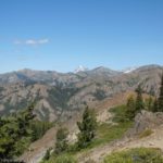
The trail itself ascends quite steeply for the next mile, switchbacking most of the way over the rocky moraine. It is very exposed, so if you’re doing this in the heat of the day, bring plenty of water. We hiked it in the very early morning, and the whole moraine was in the shadow of the mountains. It was cool, which was nice, and the views back down into the Teanaway Valley where there was sun were lovely. You can also see Mt. Rainier peaking up beyond the mountains across the valley. I actually recommend that you hike this in the morning, as the early morning sun is so pretty, though the views of Mt. Stewart may be better later in the day when the sun is shining directly one it. As it was, the sun was pretty directly on it, since you are on the southwest side of the mountain.

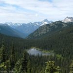
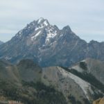
Quite suddenly, the switchbacks will end, and you will come up into a saddle. Across the valley from you looms the awe-inspiring form of Mt. Stewart, complete with flecks of snow on it (at least when we were there in August). Go over to the edge, and let your jaw drop. It’s beautiful, especially in the early morning light shining down on it. You can also see the valley between you, which is quite pretty.
When you can tear yourself away, go right (when your facing Mt. Stewart) up the old mining road. After not too long you will come up to the top of the ridge. From here you can get an even better view of Mt. Stewart, although the valley is partially obscured from here. This is a great place to have a snack, snap pictures, or simply sit and enjoy the view.

This was one of my favorite hikes that I did in the Teanaway Area (rivaled by Bean and Earl Peaks). So if you’re looking for a nice place to gaze at a nicely shaped, awesome mountain, try this viewpoint of Mt. Stewart…and enjoy the view.
Round Trip Trail Length: 6 miles
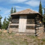
Facilities: Primitive wheelchair accessible restroom, a couple of picnic tables, and a signboard at the parking area
Fees: $5 Northwest Forest Pass required (daily fee). Interagency, Senior, Access, and Northwest Forest Annual Passes also accepted. This parking area is checked, so make sure your fee stub or pass is prominently displayed in the windshield of your vehicle.
Trail 
![]()
![]()
Road ![]()
Signs ![]()
Scenery
Would I go 100 miles out of my way for this?
Overall Rating: ![]()
This Week’s Featured Product!
I wrote this guide with both popular and less-popular hikes in mind – but all of them have great views! This hike is included in the guide.
26 responses to “The Best View of Mt. Stewart in Longs Pass”
Great post, I admire the writing style 🙂 A little off topic here but what theme are you using? Looks pretty cool.
为了学习这个知识,到处找相关文章,哎,真不容易,博主也不容易,在此也要感谢一下博主了。
Thank you for keeping us updated. I quite appreciate it and find all of the info very useful.
I adore your wp template, where did you obtain it from?
I truly wanted to write down a quick remark to thank you for these pleasant secrets you are showing at this website. My time-consuming internet lookup has at the end been rewarded with really good know-how to go over with my contacts. I feel rather grateful to have used the web site and look forward to tons of more cool times reading here. Thank you once more for all the details.
I really appreciate this post. I’ve been looking all over for this! Thank goodness I found it on Bing. You’ve made my day! Thank you again!
I was very pleased to find this site. The reason being that this is such an informative post. I wanted to thank you for this informative analysis of the subject.
You got a very superb website, Glad I found it through yahoo.
so much superb information on here, : D.
I just added this blog site to my feed reader, excellent stuff. Can not get enough!
I admire your piece of work, appreciate it for all the good content .
I’ve been absent for a while, but now I remember why I used to love this web site.Thanks , I’ll try and check back more frequently.How frequently you update your site?
My template was designed by EZwpthems.com (http://www.ezwpthemes.com/). I’m glad you like it!
I use the Tropic Affair theme from EZwpthemes.com (http://www.ezwpthemes.com/). Check out the site…it’s pretty cool!
Hi Paul,
I try to update the site at least weekly. Thank you for reading the posts!
Anne
TC,
Glad to know that the Yahoo index is working. Thanks!
Anne
AWB,
Thanks for letting me know that you found this using Bing. It’s nice to know where readers are finding my information.
Anne
Wonderful post! We will be linking to this great content on our site. Keep up the great writing.
You’ve made some really good points there. I looked on the net to learn more about the issue and found most individuals will go along with your views on this web site.
Your place is valuable to me. Thanks!…I’ll be back.
I simply want to say I am newbie to blogs and actually loved you’re web-site. Most likely I’m going to bookmark your blog post . You definitely have superb posts. Regards for sharing with us your web site.
you have a great blog here!
Hi, superior post. I have been pondering this topic, so thank you for sharing. I’ll likely be coming back to your posts. Keep up the good work
Thank you for sharing superb informations. Your website is very cool. I am impressed by the details that you have on this website. It reveals how nicely you perceive this subject.
[…] Stewart from Longs Pass, […]
[…] Stewart from Longs Pass, […]