Stiles Falls is a hidden gem deep within Virginia’s Blue Ridge Mountains. In fact, it’s so hidden that I would never have gotten to the parking area without a GPS! Thankfully, it was findable with Google Maps, and except for some rock-hop creek crossings, the path, itself, was an easy hike to a very nice waterfall. It’s located close enough to both Roanoke and Blacksburg to receive a good amount of foot traffic without being overrun.
Quick Stats
This post may contain affiliate links. If you click one and buy something, I will receive a small commission – without an extra cost for you. Thank you for supporting Anne’s Travels!
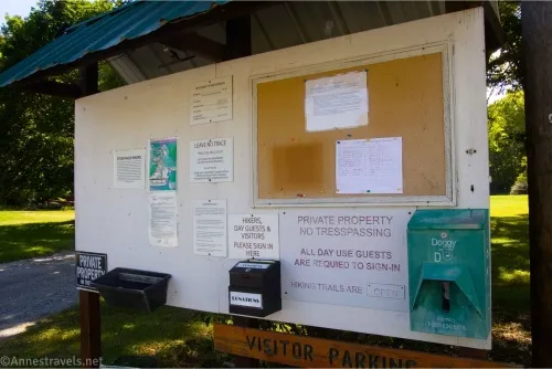
Stiles Falls is located on the Alta Mons United Methodist Church Camp property. However, the camp welcomes hikers except when camp is in session (usually about 3 weeks of the summer; the schedule for closures should be here: https://www.altamons.org/hike.html). Starting early 2025, the camp charges a $5 parking fee (“contribution” or “donation” if you wish to call it that, and it really does help with the upkeep of the property) – I visited in the fall of 2024, so while there was a donation box, there was no requested/required fee at that time.
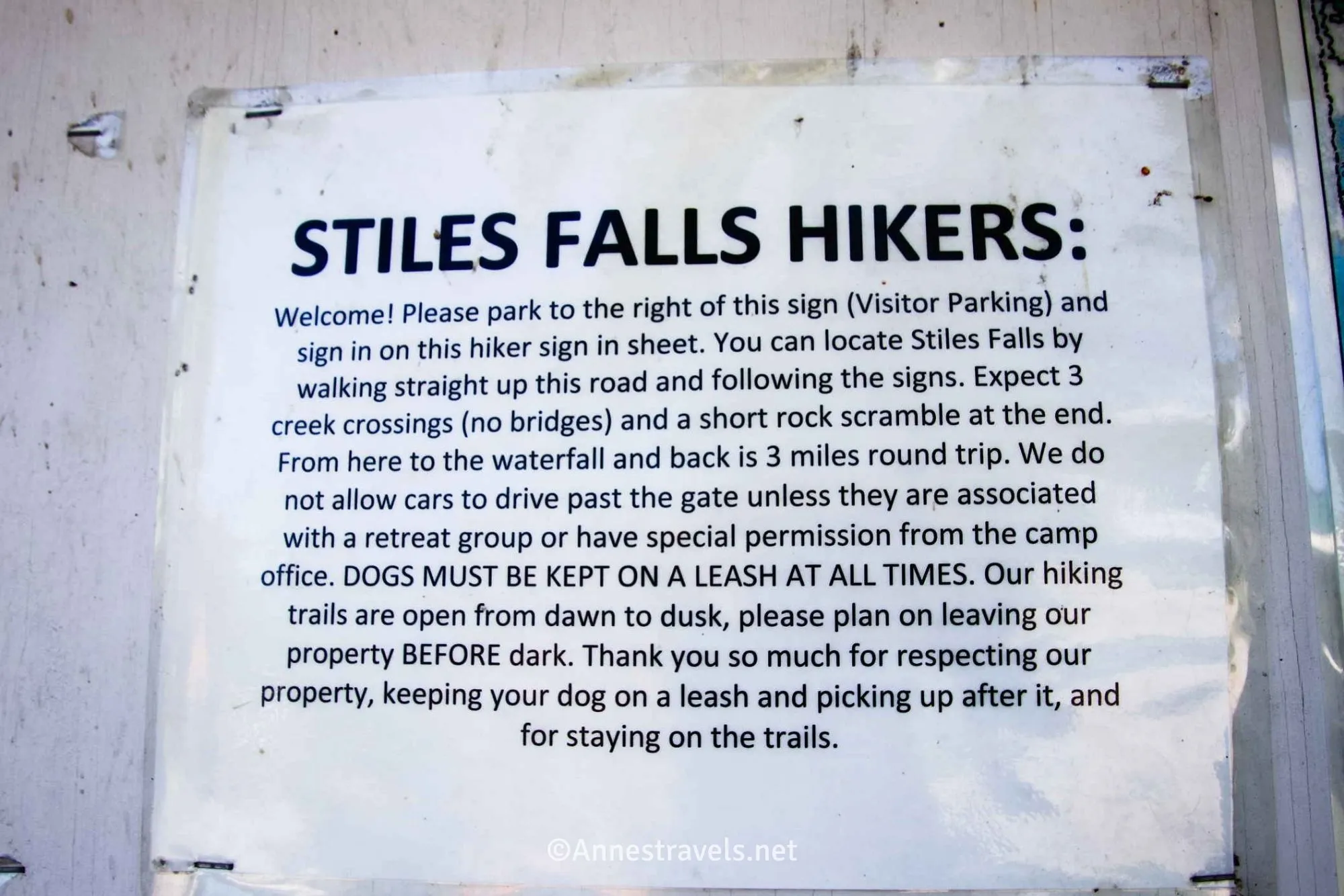
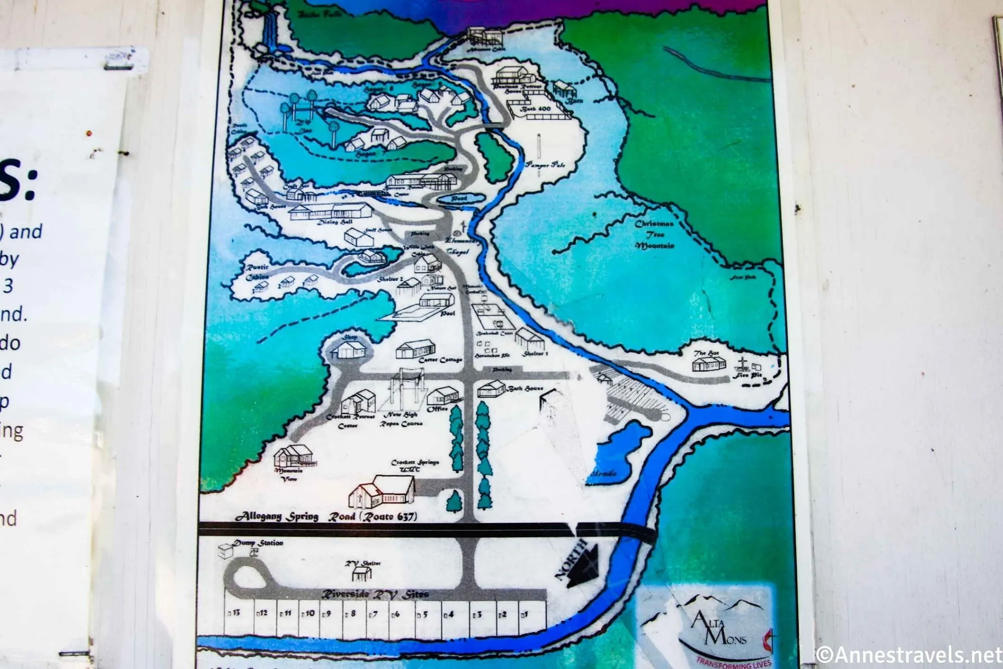
When I arrived at the camp, I was a little confused by all the roads. Thankfully, a sign indicated “visitor parking” was to the right of the sign kiosk. This is where you’ll want to park. Walk back to the sign kiosk (which has some maps of the property), then walk straight up the road just to the left of the kiosk. You’ll pass a few old cabins.
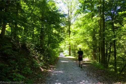
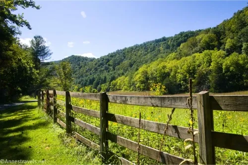
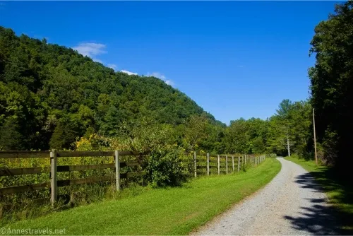
The first road junction is at 0.2 miles; turn right. The second road junction is almost a tenth of a mile later; turn right. These junctions are all well-signed. This next section was one of my favorites in terms of walking on the roads – after walking through the forest, the trees on the right give way to meadows behind rustic fences. There are also some retreat houses in this area.
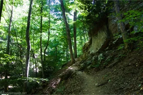
Shortly after passing the houses, the well-used road will end and you’ll come to a junction (mile 0.9). Turn left here on a trail. About a tenth of a mile later, you’ll want to turn left – again, these junctions are well-signed. The path descends to Purgatory Creek (a little funny for a Methodist camp). Over the next 0.6 miles, the path (which is now in the deep woods and mostly follows the creek) will cross the creek three times.

The path along the creek is sometimes easy and sometimes a little sketchy. It’s perfectly safe, just not the wide, easy trail you’ve had up until this point.
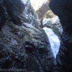
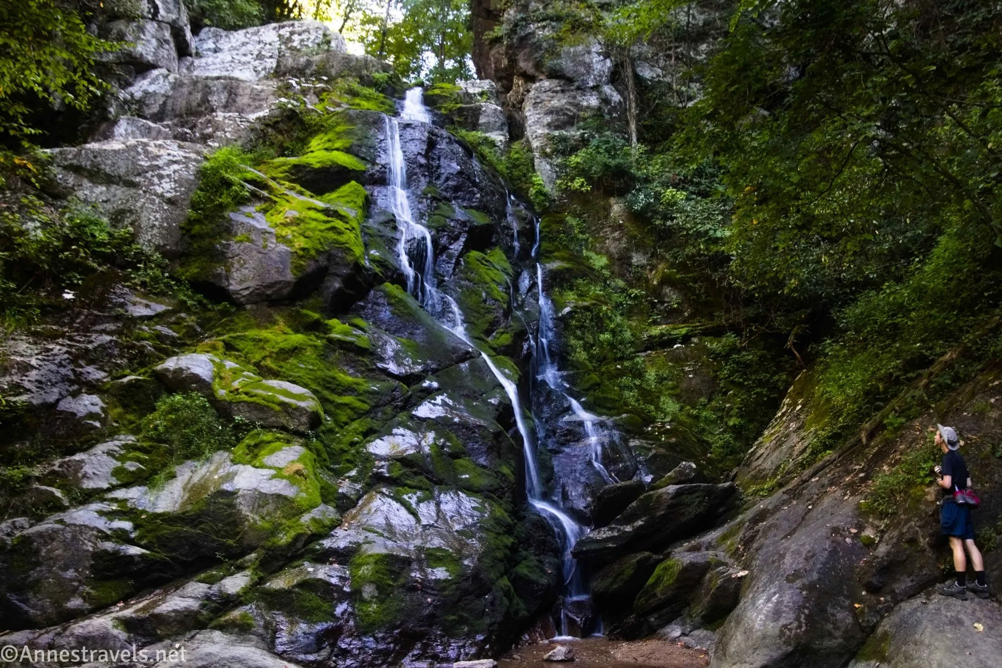
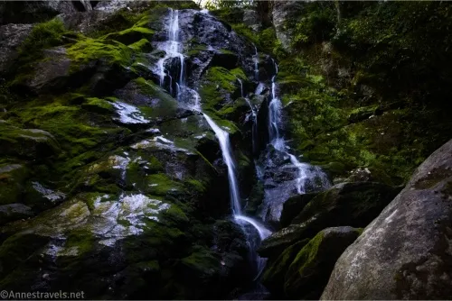
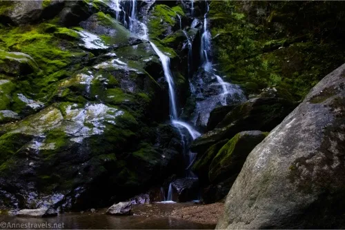
At mile 1.6, you’ll come to Stiles Falls. It’s a little hard to see without some Class 2-Class 3 scrambling over boulders, but it’s worth the effort to get a good view.
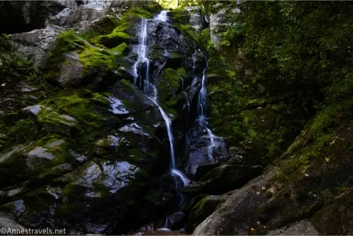
The amount of water on the falls will depend on the current time of year, but it does flow year-round and is icy in winter. I visited in early September, and the falls certainly weren’t full. I scrambled around to get different angles before retracing my steps to the trailhead.
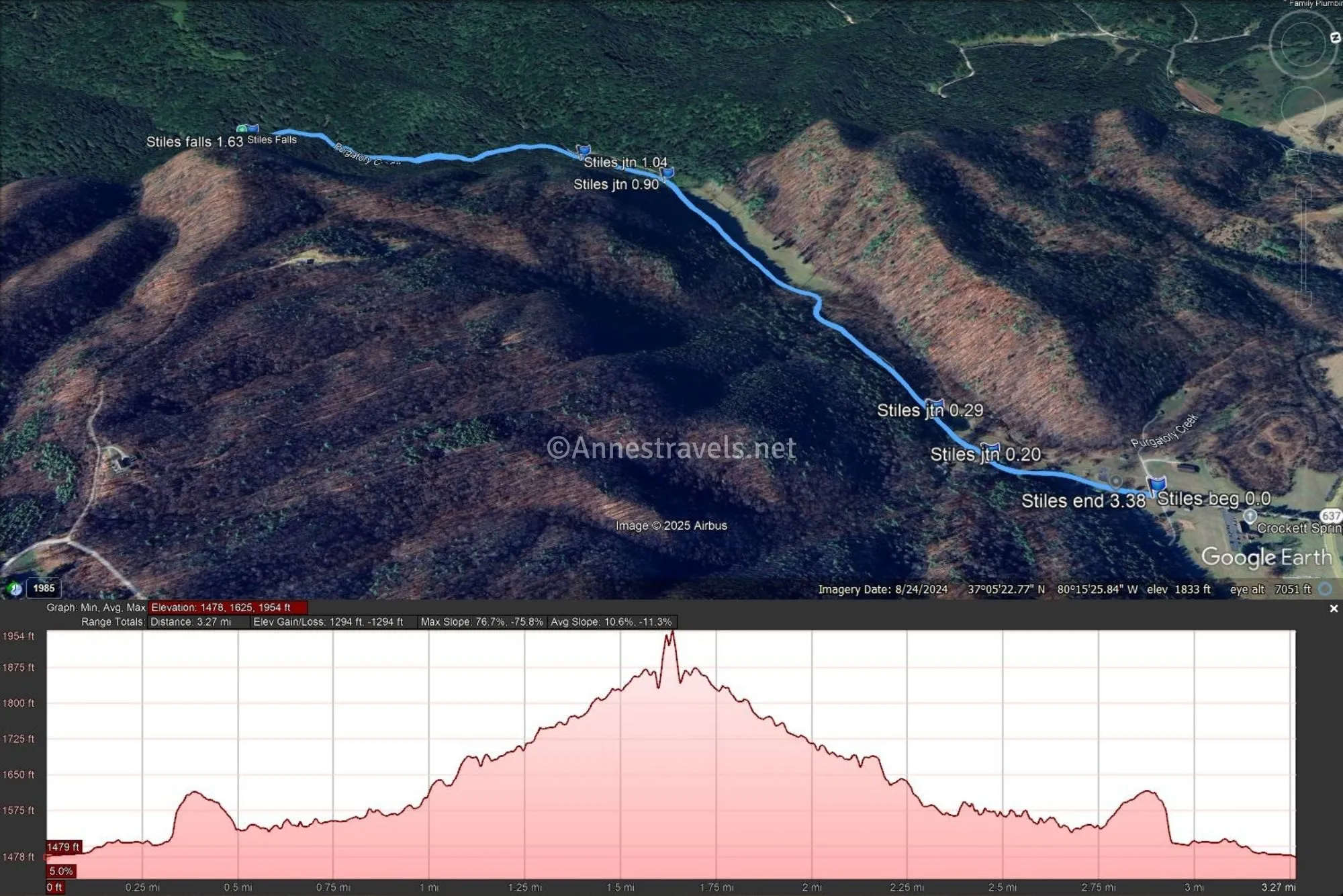
Round Trip Trail Length: I went 3.4 miles
Elevation Gain: 1,294ft. (1,478ft. to 1,954ft.)
Facilities: None. There is no open restrooms on the property for public use.
Fees: $5 to park. Not covered by any pass, as this is private property.
Trail Notes: This is private property, and there are signs saying so. However, you’re welcome to come on the property to hike as long as you are respectful and follow their rules (mostly things like stay on trails, no driving beyond the gate, dogs must be on a leash, no alcohol or weapons on the property, leave by dusk, etc. – like any good Christian camp, there are plenty of rules!) The route is well-signed, so keep your eyes open at junctions. The camp is closed to visitors while camp is in session – https://www.altamons.org/hike.html should have updated information as should the camp Facebook page.
Trail 
![]()
![]()
Road ![]()
Signs ![]()
Scenery ![]()
![]()
Would I go 100 miles out of my way for this? ![]()
![]()
![]()
Overall Rating: ![]()
![]()
GPS Coordinates for Stiles Falls
TH (signboard): 37.0967720°, -080.2504020° (37°05.80632′, -080°15.02412′ / 37°05’48.3792″, -080°15’01.4472″) (1,475ft.) (0.0)
Road Junction: 37.0943240°, -080.2519070° (37°05.65944′, -080°15.11442′ / 37°05’39.5664″, -080°15’06.8652″) (1,506ft.) (0.2)
Road Junction: 37.0937890°, -080.2533800° (37°05.62734′, -080°15.20280′ / 37°05’37.6404″, -080°15’12.1680″) (1,502ft.) (0.29)
Junction: 37.0905520°, -080.2630500° (37°05.43312′, -080°15.78300′ / 37°05’25.9872″, -080°15’46.9800″) (1,566ft.) (0.90)
Junction: 37.0888660°, -080.2643930° (37°05.33196′, -080°15.86358′ / 37°05’19.9176″, -080°15’51.8148″) (1,587ft.) (1.04)
Stiles Falls: 37.0817460°, -080.2660730° (37°04.90476′, -080°15.96438′ / 37°04’54.2856″, -080°15’57.8628″) (1,829ft.) (1.63)
End (signboard): 37.0967560°, -080.2503660° (37°05.80536′, -080°15.02196′ / 37°05’48.3216″, -080°15’01.3176″) (1,475ft.) (3.38)
The gpx file for Stiles Falls can be downloaded – please note that this and the GPS Coordinates are for reference only and should not be used as a sole resource when hiking this trail.
Download GPX File size: 41.9 KB Downloaded 82 times
(Note: I do my best to ensure that all downloads, the webpage, etc. are virus-free and accurate; however, I cannot be held responsible for any damage that might result, including but not limited to loss of data, damages to hardware, harm to users, from use of files, information, etc. from this website. Thanks!)
Getting to Stiles Falls Parking Area
My recommendation is to put the TH GPS coordinates into your map program and ask it to take you there. However, there is no cell signal out here, so download offline maps before you leave – I got there just fine, but when I went to go back to where I was staying, I had no way to figure out how to map my way out! We ended up driving a lot of crazy, rural roads – but we did make it back without any (too) wrong turns!
From Roanoke, take I-81 South to Exit 132 (VA-647 toward Dixie Caverns). Turn left onto State route 647 for 0.2 miles, then turn right onto US-11S for 8.4 miles. Turn left onto State Route 637 (Alleghany Spring Road) for 6 miles, then turn right onto Crocket Springs Road (the camp road) for 0.2 miles to the signboard – turn right into the visitor parking lot.
From Blacksburg/Christiansburg, take I-81N to Exit 118 C (toward Shawsville and Elliston). Merge onto Roanoke Street for 1.6 miles, then turn right onto Mt. Pleasant Road SE. After a mile, turn left onto SR-638 for 3.4 miles, then turn right onto SR-637 for 3.2 miles. Turn right onto Crocket Springs Road (the camp road) for 0.2 miles to the signboard – turn right into the visitor parking lot.
More Hiking in the Roanoke Area
Explore the mountains, waterfalls, and more around Roanoke, Virginia, with this guide. Forty hikes take you to some of the best scenery in southwestern Virginia. Buy your copy here.