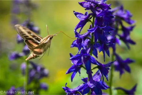
I heard Blue Lake in Colorado was implementing a permit system, and I determined I would visit before the system went into place. That was no easy feat, but we did it, and I’m so glad we did! The scenery was absolutely spectacular, the lakes were lovely, and now I’m dreaming of going back to the San Juans to check out more hikes in the area. But to the point of this post, we ended up seeing Blue Lake, Middle Blue Lake, Upper Blue Lake, and then continuing up to Blue Lakes Pass (mostly used by summit baggers heading for 14er Mount Sneffels). You don’t have to do all of this, but I do recommend Upper Blue Lake if you have time and energy – it’s stunning!
Quick Stats
The trail was closed during the 2025 season, but it will hopefully reopen in 2026 with permits. On the experience of one day, I’d say they don’t really need day hiking permits as much as backpacking permits – the entire area around Lower Blue Lake was flattened by backpackers (not day hikers, but backpackers). So overused.
But the trails, etc., really weren’t that bad compared to a lot of places, especially in the High Sierra (which I’d visited earlier on the same cross-continent adventure, and no one seems to be accusing most of those trails of being overused). While these had seen some use, I wouldn’t have called most of them “overused” at all. So I hope the powers that be open up the area to day hiking again in the future. I hear there are some improvements happening to the trailhead, including new restrooms and signboards.
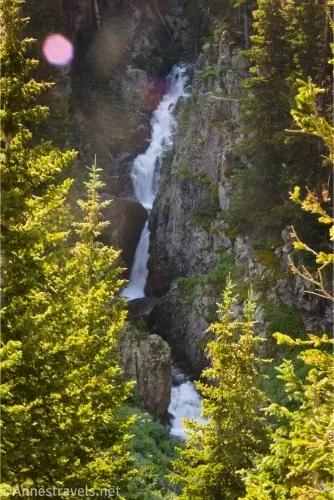
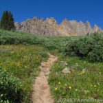
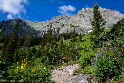
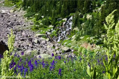
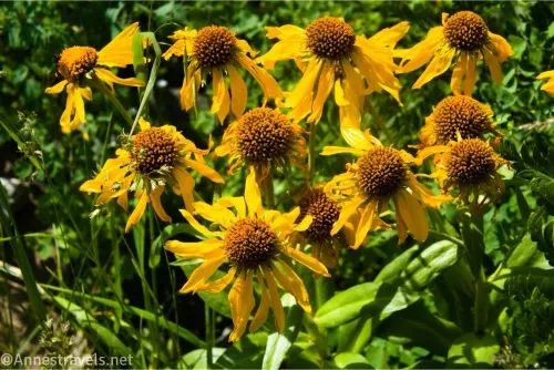
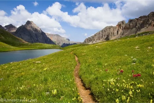
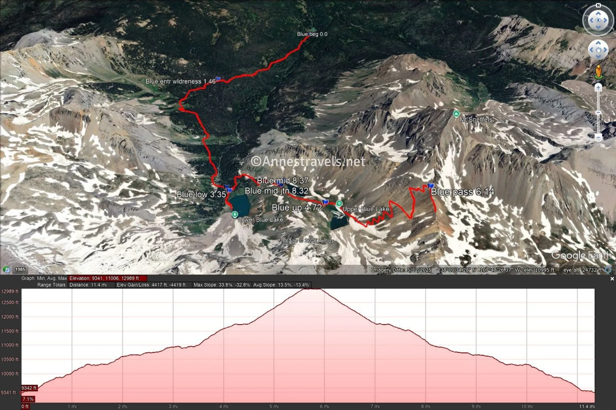
0.0 Blue Lake Trailhead (9,362ft.). Walk around the gate and continue to follow the trail. It almost immediately begins uphill, and it will continue uphill for most of the trek. The path is through the forest at this point. Enter the Mount Sneffels Wilderness about mile 1.4. After this, views begin to open up to classic San Juan-style mountains. Wildflowers fill the meadows in the summer. You’ll also be able to hear a waterfall, but you never get a very good view of it. (38.0345420°, -107.8064340°)
3.3 Trail Junction (10,981ft.). The left trail crosses the Lower Blue Lake Outlet and heads up toward Middle Blue Lake. For now you want to turn right and head up to Lower Blue Lake. There are a ton of social trails in this area, most of them leading to camping sites. Try to stay on the main path. (38.0026760°, -107.8168740°)
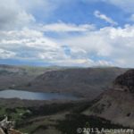
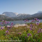
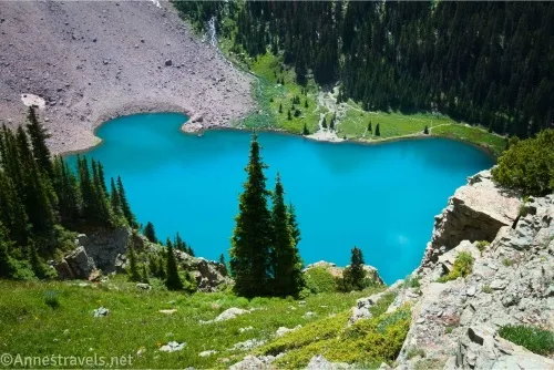
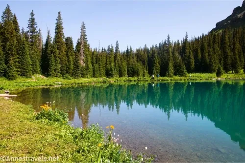
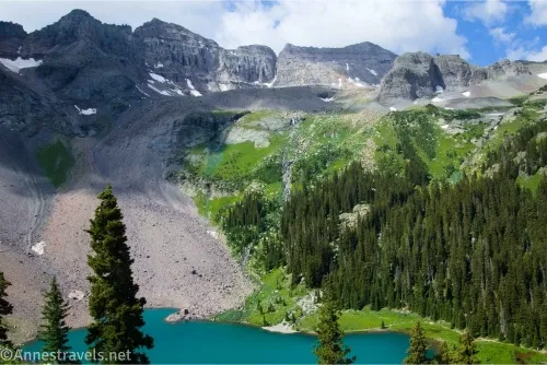
3.35 Lower Blue Lake (10,981ft.). Turn right to work your way along the right (western) side of the lake. Actually, you can probably go left, too, but you’ll pretty quickly come to the lake’s outlet. Views are gorgeous over the lake and to nearby mountains. (As a total side note, I arrived very early in the morning, and I don’t know what a group of teens was doing beside the lake, but they shaped up their act as soon as they saw us coming. I saw their leader later (middle-aged guy), and he was one weird cookie – the kind I try to get away from about as fast as I can. So I’m sure you’ll have a much better experience at Lower Blue Lake than I did.) Many people turn around here, but I opted to go back to the junction and head up toward Middle and Upper Blue Lakes. (38.0022400°, -107.8164830°)
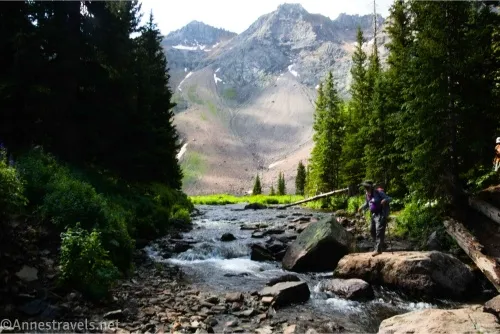
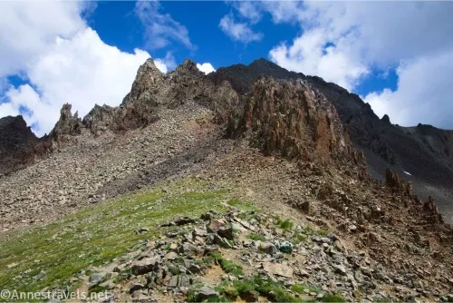
3.4 Lower Blue Lake Outlet (10,979ft.). There are quite a few places to cross; I chose one with some promising-looking logs and didn’t get wet feet. Beyond the crossing, head up – and when I say up, I mean up! The path skyrockets upward at an alarming pace, and the trail is both very narrow and very slippery in places. In fact, I wondered for a bit if we were on a social trail; it just didn’t look that well-used. Hiking poles are useful, especially when coming back down. There are a few places where Lower Blue Lake can be seen clearly below you. This is an absolutely spectacular view, one of the best on the entire hike. Sadly, the sun decided to go under just when I got to this point on both the trek up and the trek down, so my photos don’t do the view anything close to justice. (38.002678°, -107.816454°)
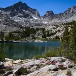
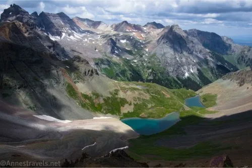
4.2 Junction for Middle Blue Lake (11,566ft.). A trail on left goes down to Middle Blue Lake – the main trail doesn’t go to the lake, so if you want to visit it, you’ll need to take this detour. On my way up, I didn’t (because I figured the trail would go along the lake, just like most trails near lakes), so I won’t include the detour in my mileage, though I did go to the lake’s outlet on my way back down. The trail passes above Middle Blue Lake and then ascends a meadowed slope to get to Upper Blue Lake. Views are very good along this part of the trail. (38.0018160°, -107.8107090°)
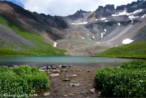
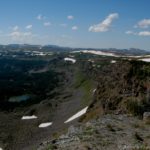
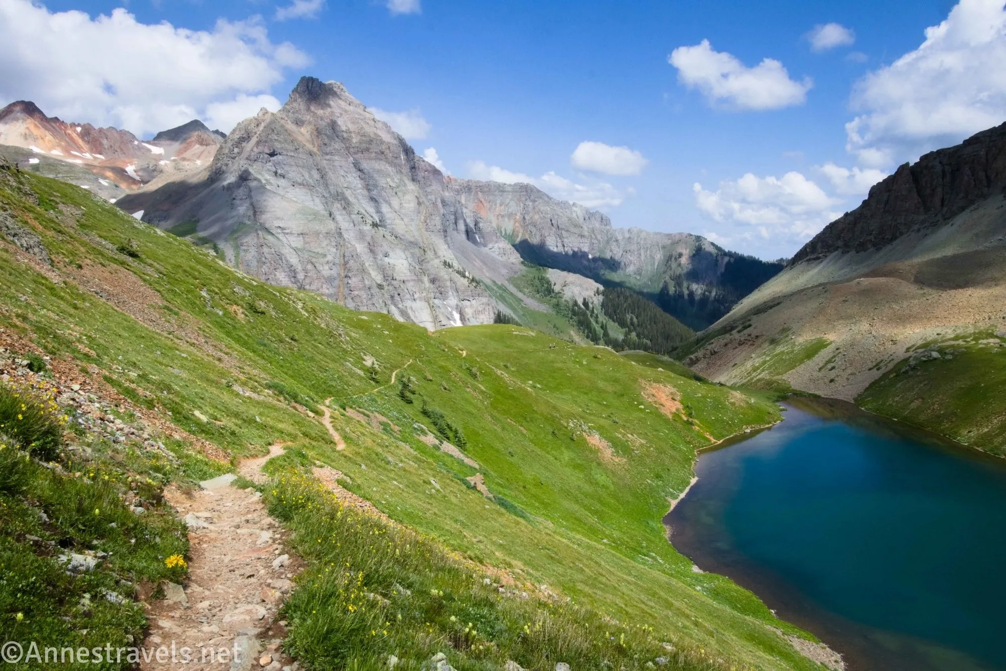
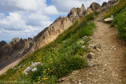
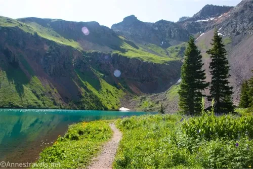
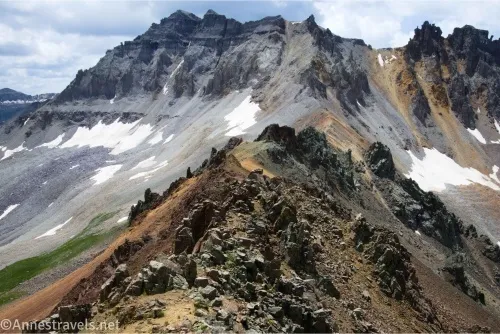
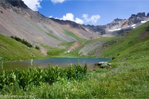
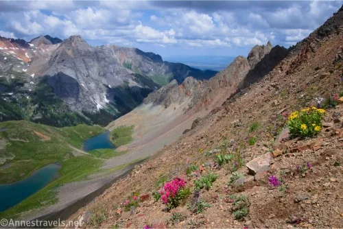
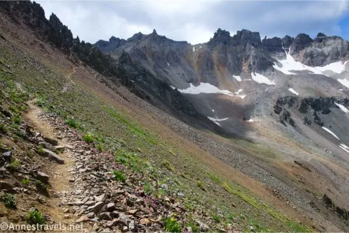
4.7 Upper Blue Lake Outlet (11,724). The trail crosses the outlet and runs along the lake’s left shore (eastern shore) before beginning to take long switchbacks up the hillside. What is meadows at first becomes scree, but the trail remains in good shape. Views become better and better as you climb. This is one spectacular (and hard!) hike! Near the ridgeline, there are a few short Class 3 scrambles – use caution as there is some exposure in places. (37.9991940°, -107.8055000°)
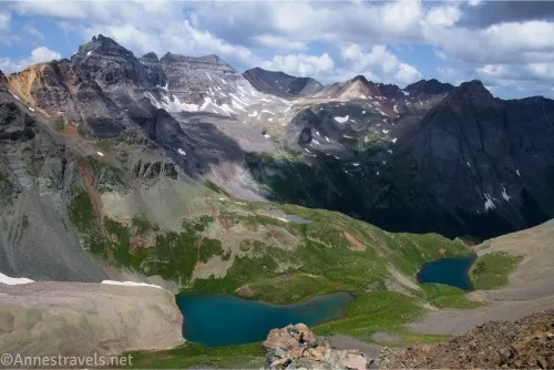
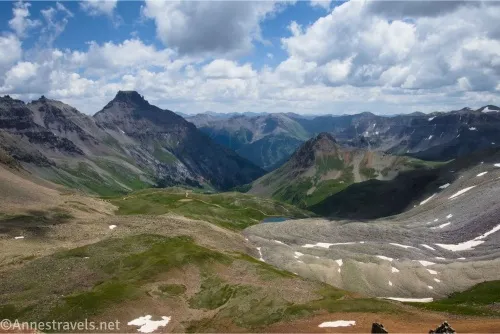
6.2 Blue Lakes Pass (12,979ft.). The views from both sides of the pass are beyond spectacular. Yankee Boy Basin is on the far side – if you have a good jeep, you can drive to the basin and then hike from there (and if you don’t have a jeep, you can drive partway up the road and hike up – no need for permits from that direction!) (37.9980470°, -107.7951470°)
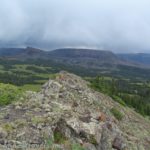
What I should have done at this point – what would have been the responsible, reasonable thing to do at this point – was to turn around in the pass and go back. Or maybe turned left and headed up toward Mount Sneffels, like most of the other hikers around me. Instead, we succumbed to altitude-brain, turned right, and scrambled along the ridgeline. It was great on multiple counts, one is the views, and another is that we left everyone else behind very quickly. However, it was some serious Class 3 scrambling with a few Class 4 moves. I don’t recommend it unless you’re comfortable with scrambling and some amount of exposure.
We went about 0.15 miles along the ridge before remembering that we had to get back before dark. (Actually, the afternoon thundershower held off for us that afternoon, and I’m so grateful – people who had been in the area the day before told us of the crazy storm they’d endured in place of the normal monsoon.) So we “just” had to retrace our steps down, and down, and down back to the trailhead!
Round Trip Trail Length: I went 12.6 miles; there are multiple ways you could make it shorter
Elevation Gain: 4,419ft. (9,341ft. to 12,989ft.)
Facilities: None in 2024, though I hear they are installing trailhead vault toilets
Fees: None
Trail Notes: This is one hard hike! It was the last hike for me on a four-week trip where we hiked 200 miles in the Pacific Northwestern US (and one hike in Colorado), so we had some pretty good trail legs. Even so, the elevation was hard on me, as was the extremely steep trail. Hiking in September or before the snow falls in October is best to avoid the daily afternoon thunderstorms. Or start at 3am – no judgment here!

Trail 
![]()
![]()
Road ![]()
Signs ![]()
![]()
![]()
Scenery
Would I go 100 miles out of my way for this?
Overall Rating: ![]()
GPS Coordinates for Blue Lake
TH: 38.0345420°, -107.8064340° (38°02.07252′, -107°48.38604′ / 38°02’04.3512″, -107°48’23.1624″) (9,362ft.) (0.0)
Enter Wilderness: 38.0209460°, -107.8209210° (38°01.25676′, -107°49.25526′ / 38°01’15.4056″, -107°49’15.3156″) (10,337ft.) (1.46)
Junction (upper vs. lower): 38.0026760°, -107.8168740° (38°00.16056′, -107°49.01244′ / 38°00’09.6336″, -107°49’00.7464″) (10,981ft.) (3.31)
Lower Blue Lake: 38.0022400°, -107.8164830° (38°00.13440′, -107°48.98898′ / 38°00’08.0640″, -107°48’59.3388″) (10,981ft.) (3.35)
Overlook of Middle Blue Lake: 38.0014660°, -107.8103940° (38°00.08796′, -107°48.62364′ / 38°00’05.2776″, -107°48’37.4184″) (11,601ft.) (4.39)
Head up (Upper Blue Lake Outlet): 37.9991940°, -107.8055000° (37°59.95164′, -107°48.33000′ / 37°59’57.0984″, -107°48’19.8000″) (11,724ft.) (4.72)
Blue Lakes Pass: 37.9980470°, -107.7951470° (37°59.88282′, -107°47.70882′ / 37°59’52.9692″, -107°47’42.5292″) (12,979ft.) (6.14)
Middle Lake Junction: 38.0018160°, -107.8107090° (38°00.10896′, -107°48.64254′ / 38°00’06.5376″, -107°48’38.5524″) (11,566ft.) (8.32)
Middle Blue Lake (near outlet): 38.0021040°, -107.8100190° (38°00.12624′, -107°48.60114′ / 38°00’07.5744″, -107°48’36.0684″) (8.37)
End: 38.0346400°, -107.8071390° (38°02.07840′, -107°48.42834′ / 38°02’04.7040″, -107°48’25.7004″) (9,359ft.) (12.61)
The gpx file for Blue Lakes can be downloaded – please note that this and the GPS Coordinates are for reference only and should not be used as a sole resource when hiking this trail.
Download GPX File size: 158.8 KB Downloaded 21 times
(Note: I do my best to ensure that all downloads, the webpage, etc. are virus-free and accurate; however, I cannot be held responsible for any damage that might result, including but not limited to loss of data, damages to hardware, harm to users, from use of files, information, etc. from this website. Thanks!)
Getting to Blue Lake
From US-550 in Ridgway, turn onto CO-62W for 4.8 miles. Turn left onto County Road 7 for 0.4 miles, then take a slight left to stay on County Road 7. After 1.7 miles, take a slight right to stay on the same for another 6.8 miles to the trailhead. Note that there is a lot of private property along the road, so be careful where you park. When I visited, people free-range camped up near the trailhead, but I don’t know how the rules will change with the 2025 improvements.
From Ouray, take US-550 for 10 miles to turn left onto County Road 62 W toward Ridgway. Follow the directions (above) to the trailhead.
I Collected Some of the Most Beautiful Hikes in Colorado
I put some of my favorite – and the most beautiful – hikes in Colorado into this book! It includes over 30 hikes, pictures, maps, detailed directions, and much more. Buy your copy here.