

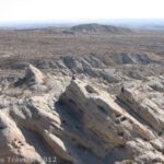
The plates have shifted along the San Adreas Fault, shifting the course of the stream
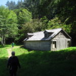
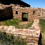
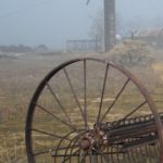
Carrizo Plain National Monument is fairly new as national monuments go. The park was established in 2001 from land in Southern California that had been a part of the Carrizo Plain Natural Area. When I visited the monument a couple years ago, I found that it had barely been developed, although there was a visitor center, a few campgrounds, a boardwalk out into Soda Lake, some historic farm exhibits (more on those in another post!), and a few trails scattered here and there. One of the most exciting parts of the visit for my group was walking on the San Andreas Fault Line at the Wallace Creek Trail. I guess not being from the area, we found it quite exhilarating to walk on the actual fault and see evidence of how the plates are shifting underneath our feet. If you’re in the area and want to have a great Facebook status that day (“I walked on top of the San Andreas Fault today”), I recommend that you stop by the no-admission-fee park and walk on the fault for yourself!
To get to Carrizo, from I-5, take Exit 257. If you’re coming from the north, this exit will drop you directly onto the Blue Star Memorial Highway (State Hwy 58); turn right and head west. However, if you’re coming from the south, this exit will drop you onto Tracy Avenue; turn right and then turn right again on Blue Star Memorial Highway (State Hwy 58). Stay on State Hwy 58 through the “town” of Buttonwillow. After about 16 miles you will need to turn left on 2nd Street in the “town” of McKittrick for a mile or so, and then turn right back onto State Hwy 58. (Another way of saying this is that State Hwy 33 will intersect State Hwy 58; turn left and drive through McKitterick. Then, 2.6 miles later, turn right to continue on State Hwy 58, leaving State Hwy 33 behind). Continue on State Hwy 58 for another 17 miles to a little tiny road called 7 Mile Road. Turn left on this road and go 0.3 miles before taking the first left onto Elkhorn Road. Take Elkhorn Road for 4 miles to a small parking area on your left. Be aware that Elkhorn Road is dirt, but passible by low-clearance vehicles if it hasn’t rained recently. You can check for road conditions at the visitor center near Overlook Hill (continue down 7 Mile Road and then turn left onto Soda Lake Road).

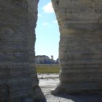
View from along the trail
If you’re coming from the main part of the park, take the Soda Lake Road to 7 Mile Road north of Soda Lake. Turn right and follow the road for 3 miles to Arrow Bear Trail. Turn right, and follow this road for 2.4 miles to Elkhorn Road. From here, turn right again and follow the road 2.3 miles to a small parking area on your left.
Alternatively, from US 1 (San Luis Obispo), drive approximately 9 miles north on US-101. Take Exit 211 to merge onto CA-58 East. Continue on CA-58 for 42 miles to 7 Mile Road. Turn left on this road and go 0.3 miles before taking first left onto Elkhorn Road. Take Elkhorn Road for 4 miles to a small parking area on your left.
***Important Note*** Google Maps and GPSs are notorious for getting these directions wrong, so be forewarned that there may be errors in their directions!

Close-up of the stream bed that moved
The parking area doesn’t inspire much confidence. It’s just this little dirt area with waving grass and uninteresting scenery around it. But don’t be fooled: you are actually on the verge of the San Andreas Fault. Pick up a self-guiding pamphlet from the box in the parking area; this will explain about the fault and what you are seeing here. (You can also print out the pamphlet at http://www.scec.org/wallacecreek/pdf/trailguide.pdf). Follow the fence along the trail that starts from the left (if your back is to the road) side of the parking area. You will follow the fence for about ¼ mile to the fault line itself. There are signs along the way that explain the geology of the area.
After the ¼ mile, the trail splits into three. If you want a good view of the fault and want to see how it’s taken a dry creek bed and given it a 90 degree turn, continue straight up a little hill (to stop 1 in the pamphlet). This is a slight scramble compared to the rest of the hike, but isn’t that steep as trails go. From the hillside, look over to your left. Here you can see how the plates have moved, creating a zigzag course for the stream. Apparently, in January of 1857 an earthquake shook the area and moved the creek a full 30 feet (9 meters) from its original course. I think my picture illustrates the different plates pretty well, and shows you what the plate movements did. On the left (the young lady in the red shirt on the path) is the Pacific Plate, while on the right (the girl in the pink shirt on the hillside) is the North American Plate. The San Andreas Fault Line separates the two down the middle of the creek bed.

A visualization of the shifted stream bed
After you get done looking at this, you can either return to your vehicle (you’ve seen the best from the hillside), or you can finish the trail and make it about 1.25 miles RT. If you want to walk the rest of the trail, I would suggest turning right after you come down from the hillside (that’s left if you are coming from the parking area; this will take you to stop 2 on the pamphlet). This short trail will take you to the other end of the 90 degree curve. It doesn’t look that impressive, but when you think about what happened here, it’s very impressive. (Are you sure there are no earthquakes in the forecast for today???)
When you’re done looking at the curve up close, retrace your steps and keep walking straight when you get to the trail junction (that would be turning left when coming down off of the hillside or right when coming from the parking area). This trail is slightly longer and takes you to stops 3, 4, and 5 on the pamphlet. Along the way you can see more evidence of the fault moving, including two parts of a drainage channel that have been moved away from each other along the fault line and a channel that appears to have no source except a steep hillside. As I said above, stop 1 is by far the best, but the others are interesting too, especially if you like geology and seismology (the study of earthquakes).

The Wallace Creek Trail
Return to your vehicle the way you came. Most of us think of earthquakes as being completely under the ground or as only being evident from the havoc they do to buildings. However, there are more subtle ways of seeing how earthquakes can affect the “seeable” parts of the earth, and Wallace Creek is a great place observe what the faults under the earth are doing when they crunch together in an earthquake.
Round Trip Trail Length: 0.5-1.25 miles
Facilities: Signs; other than that, none
Fees: None
Trail 
Road
Signs
Scenery
Would I go 100 miles out of my way for this?
Overall Rating:
This Week’s Featured Product!
From the coast to the mountains to the desert, this guide offers so many opportunities to hike in varied terrain and views.
I am constantly browsing online for ideas that can facilitate me. Thx!
I am planning our trip so for me this is really interesting.
Thank you a lot for sharing this with all of us you actually recognise what you are talking abtou! Bookmarked.
Pingback: 10 of the Best Free Historical Sites in America - Anne's Travels