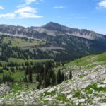
The Terrace Mountain Loop was a hike in Yellowstone that piqued my interest for no particular reason, similar to the Lamar River Trail. But I’m so glad we did it! The miles through meadows with fantastic views were worth the entire length of the loop, plus we had great views to the mountains near Mammoth and some cool rock formations in the “hoodoos” section of the trail. It’s definitely an overlooked gem of a hike that showcases a less geothermal side of Yellowstone National Park.
Quick Stats
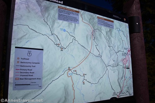
The loop is actually a collection of trails that circle Terrace Mountain – so you won’t be climbing the peak. I’m sure the views would be good from up there, but instead, you’ll get a slightly more intimate view of the surrounding scenery. The tree trails that make up the loop are the Fawn Pass Trail, the Snow Pass Trail, and the Hoodoos Trail.

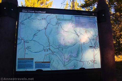
The parking area is technically the “Glen Creek Trailhead” and is also an overflow lot for the Bunson Peak Trailhead (which is almost directly across the road). It’s a relatively new and fairly large lot – I’d say it was put in as a staging area for roadwork, then converted into a trailhead. The large size means that it’s suitable for horse trailers as well as quite a few vehicles.
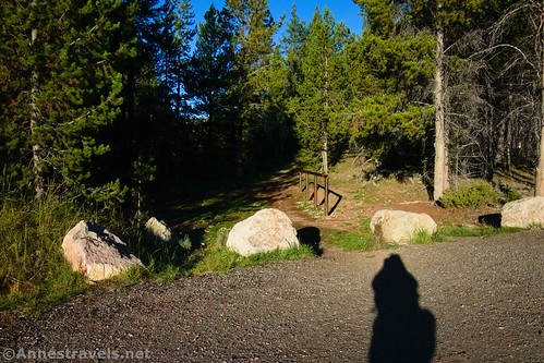
From the parking area, walk over to the southwest corner of the lot (left if your back is to the road). It’s a little difficult to find the trailhead, even if the trail itself is wide – look for the hitching rails. Walk left, down the trail, and you’ll fairly quickly come to the trail signs, marked as the Glen Creek Trailhead.

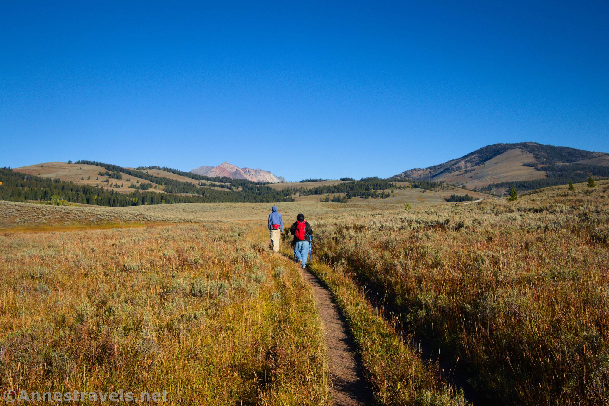
Just beyond this, the trees end in rolling, grassy plains – turn right on the trail through the grass (if you turned left, you’d pretty quickly come to the road). A short distance later, a trail goes off on the right – a sign points straight ahead for the Howard Eaton Trail. The unmarked trail on the right is the return of the loop (the Hoodoos Trail).

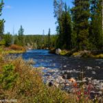
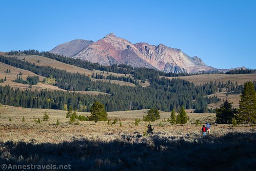
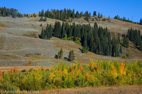
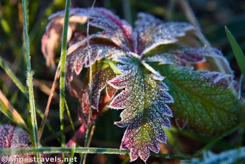
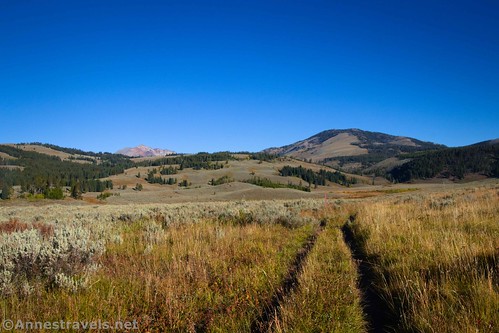
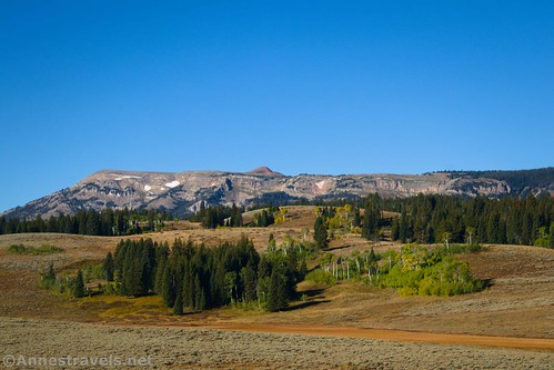
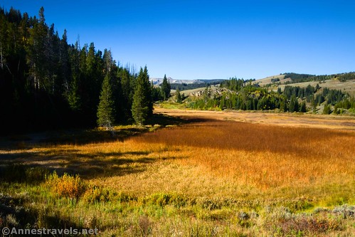
From here, the trail gently descends through the rolling prairie, covered in grass and sage brush. In the autumn, it was a spectacular place – alone, hemmed in by the mountains on three sides, the grass yellow-brown and nearby trees turning their fall colors. Incredible!
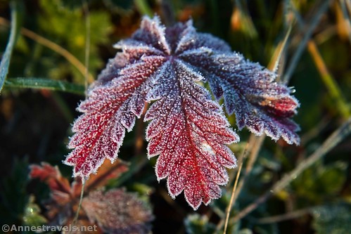
It was also very early morning, so the meadows were still frosty.
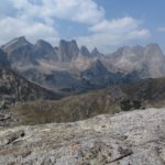
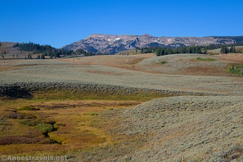
The trail turns around the shoulder of the hill of Terrace Mountain to descend into the valley. Electric Peak rises high above the other mountains, slowly disappearing behind Sepulcher Mountain as you hike deeper into the valley.

To me, this valley was the most beautiful part of the hike. Of course, I had the trees turning color and the golden meadows at Golden Hour, which probably helped.
At 2.1 miles, you’ll come to a trail that strikes off to the right – a sign marks this as the Snow Pass Junction. This is the cutoff trail to the Snow Creek Trail, so if you’re doing this as a loop, you’ll want to turn right here. I wanted to go on to the real junction (professional reasoning here), so I turned left toward Sepulcher Mountain and Sportsman Lake.
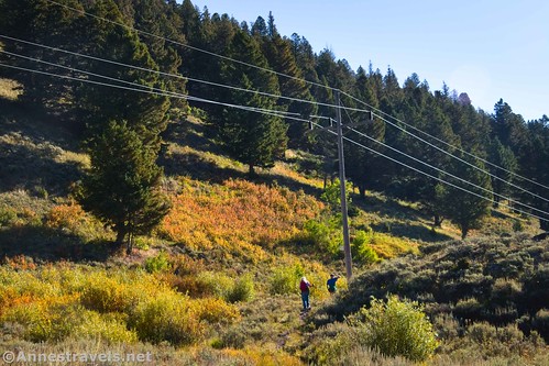
A quarter-mile later, you’ll come to a second junction. Turn right away from Cache Lake, Electric Pass, and Sportsman Lake. The trail works its way along the side of the hill and then up into Snow Pass along some powerlines.
At this point, you’re leaving behind the good views and also the easy trail. The climb up isn’t so bad. But going down the other side is very steep! And the worst part was that we knew we’d have to regain all of that elevation on the other side. As you pass through Snow Pass, Terrace Mountain will be to the south (right) and Clagett Butte will be to the north (left).
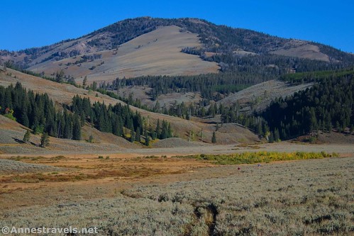
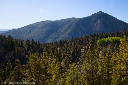
The Clagett Butte Trail strikes off left at mile 3.4 – just before the worst of the steepness. Keep walking downhill through the thick forest. A good view of Bunson Peak appears through the trees about 0.7 miles later.
The next junction is with the Howard Eaton Trail between Mammoth and the Golden Gate. If you kept walking straight (downhill) here, you’d come to the Snow Pass Trailhead. I did it for the sake of photos, but I didn’t take my GPS with me. You want to turn right (toward Golden Gate) to begin the ascent back up to the western slopes of Terrace Mountain.
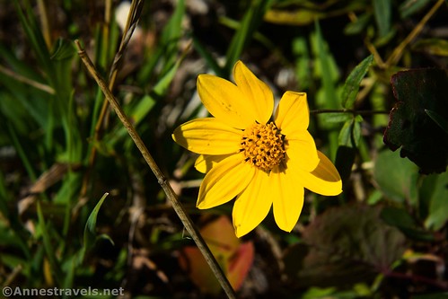
The trail climbs steadily if not as steeply as the path down from Snow Pass. Even better, the trees thin to reveal tree-studded meadows – which means you get views to the surrounding area. I also found several autumn wildflowers. The views improve of Bunson Peak and the mountains around Mammoth as you climb higher.
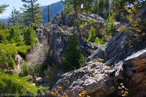
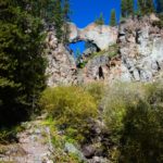
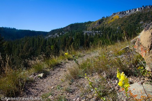
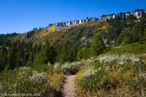
Without fanfare, and sometime after the 5 mile point, the trail suddenly enters the Hoodoos. This is not like Bryce Canyon; it’s cliffs up on the hillside (on top of Terrace Mountain) and a crazy jumble of rocks. But it’s also super cool! I had a great time walking through this area, which ends at mile 5.9 as the path reenters the forest.

As you walked through the Hoodoo section, you were above “Silver Gate” down on the main road. This was where the old road passed between huge boulders – it was later widened and straightened for easier driving. Looking back, you can see the road winding its way around where Silver Gate used to be.

You’ll also hike above Golden Gate, though you can’t see that from the trail. Either before or after your hike, you might want to stop and see Rustic Falls!

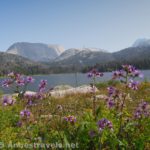
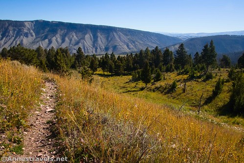
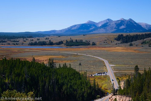
Possibly the best view on the entire loop is (almost) at mile 6.6. I call this “Swan Flat Overlook” since the unmarked viewpoint looks down on Swan Flat – and also to Swan Lake, Quadrant Peak, Bannock Peak, Dome Mountain, Mount Holmes, and beyond. It would be better in the summer than the autumn (because you’re looking south), but it was still pretty amazing on a mid-morning in September!
From here, it’s a quick (if not terribly steep) descent back to the Howard Eaton Trail at mile 7.1. Turn left to return to the parking area a tenth of a mile later.

For a little over 7 miles, it only took us the morning to do it! So while there are some steep grades, it’s also not a terribly difficult hike. (Though we’d also hiked about 75 miles in the week and a half previous, so that might have had something to do with my idea of an “easier” trail.) Plus, the views are awesome – and it’s unlikely that you’ll meet many people along the way. I call that a win-win!
Round Trip Trail Length: I went 7.25 miles
Elevation Gain: 1,134ft. (7,466ft. to 6,861ft.)
Facilities: None, not even restrooms
Fees: $35/vehicle, valid 7 days. America the Beautiful National Parks & Federal Lands Passes are accepted, as are Yellowstone National Park Annual Passes.

Trail Notes: The first half of the loop is fairly flat, while the second half is much steeper. Also, just going up to the Swan Flat Overlook would be worth the trek. And once you’re up there, you might want to continue to the Hoodoos area. So there are two ways to see part of the loop without the steepness of descending to the Snow Pass Trailhead. Of course, you’re also welcome to start at the Snow Pass Trailhead, since you more or less go right by it. The Snow Pass Trail and the Howard Eaton Trail to the Swan Flat Overlook are both signed for x-country skiers (mostly warning signs about steep grades, etc.) Most people who hike this are off to further destinations like Sepulcher Mountain, Fawn Pass, or various lakes – so it’s likely that you’ll have the trail to yourself. We saw maybe five people total in two groups, both of which were heading toward Sepulcher Mountain (not 100% sure of their final destination for the day).
Trail 
![]()
![]()
Road ![]()
Signs ![]()
Scenery
Would I go 100 miles out of my way for this? ![]()
Overall Rating: ![]()
GPS Coordinates for Terrace Mountain Loop
TH: 44.9337170°, -110.7302230° (44°56.02302′, -110°43.81338′ / 44°56’01.3812″, -110°43’48.8028″) (7,294ft.) (0.0)
Howard Eaton Junction (Fawn Pass Trail): 44.9335660°, -110.7317840° (44°56.01396′, -110°43.90704′ / 44°56’00.8376″, -110°43’54.4224″) (7,296ft.) (0.11)
Snow Pass Junction & Cutoff Trail: 44.9575960°, -110.7464090° (44°57.45576′, -110°44.78454′ / 44°57’27.3456″, -110°44’47.0724″) (7,399ft.) (2.10)
Trail Junction: 44.9596060°, -110.7479120° (44°57.57636′, -110°44.87472′ / 44°57’34.5816″, -110°44’52.4832″) (7,434ft.) (2.30)
Cutoff Comes In: 44.9602480°, -110.7436210° (44°57.61488′, -110°44.61726′ / 44°57’36.8928″, -110°44’37.0356″) (7,406ft.) (2.53)
Clagett Butte Trail Junction: 44.9608170°, -110.7280240° (44°57.64902′, -110°43.68144′ / 44°57’38.9412″, -110°43’40.8864″) (7,288ft.) (3.40)
Bunson Peak Viewpoint: 44.9594620°, -110.7164870° (44°57.56772′, -110°42.98922′ / 44°57’34.0632″, -110°42’59.3532″) (6,975ft.) (4.15)
Snow Pass/Howard Eaton-Mammoth-Golden Gate Junction: 44.9592280°, -110.7150870° (44°57.55368′, -110°42.90522′ / 44°57’33.2208″, -110°42’54.3132″) (6,872ft.) (4.35)
End of rock jumble: 44.9432430°, -110.7243700° (44°56.59458′, -110°43.46220′ / 44°56’35.6748″, -110°43’27.7320″) (7,291ft.) (5.97)
Swan Flat Viewpoint: 44.9361280°, -110.7237670° (44°56.16768′, -110°43.42602′ / 44°56’10.0608″, -110°43’25.5612″) (7,434ft.) (6.57)
Return to Howard Eaton Junction: 44.9335900°, -110.7317690° (44°56.01540′, -110°43.90614′ / 44°56’00.9240″, -110°43’54.3684″) (7,297ft.) (7.15)
End at TH: 44.9337280°, -110.7302490° (44°56.02368′, -110°43.81494′ / 44°56’01.4208″, -110°43’48.8964″) (7,294ft.) (7.26)

The gpx file for the Terrace Mountain Loop can be downloaded – please note that this and the GPS Coordinates are for reference only and should not be used as a sole resource when hiking this trail.
Download GPX File size: 103.8 KB Downloaded 102 times
(Note: I do my best to ensure that all downloads, the webpage, etc. are virus-free and accurate; however, I cannot be held responsible for any damage that might result, including but not limited to loss of data, damages to hardware, harm to users, from use of files, information, etc. from this website. Thanks!)
Getting to Terrace Mountain Loop Trailhead (Glen Creek Trailhead)
From Mammoth, drive south on US-89 for 4.8 miles. The Glen Creek Trailhead will be on the right just after exiting the Golden Gate and just before the Bunson Peak Trailhead on the left side of the road. Turn into the gravel lot and park.
From Norris Junction, drive north on US-89. After 16.2 miles, turn left into the Glen Creek Trailhead just after passing the Bunson Peak Trailhead on the right. The gravel lot is set just off the road.

Hike More Paths in Yellowstone!
Discover the places only the locals know with this book! Quiet trails, backcountry paths, and fascinating locations are all included within its pages. Buy your copy here!